WEB ENABLED OPEN SOURCE GIS
BASED TOURIST INFORMATION
SYSTEM FOR BHOPAL CITY
Sreejit S. Nair1,
M.Tech. Student
Remote Sensing and GIS Division, Department of Civil Engineering, Maulana Azad National Institute of Technology,Bhopal-51, M.P.,india
Dr. S.K. Katiyar
Associate Professor Department of Civil Engineering
Abstract: With GIS gaining its foot as a decision support system, its use is gaining relevance, but high cost of commercial GIS software hinders the growth. On the other hand the Free/Open Source Software (FOSS) has opened up a gateway for many budget restricted institutions & users to venture into GIS development. This research paper assesses the possibility of using Open Source GIS (OS GIS) based software’s to create a low cost GIS project and to publish the same over internet using free Web GIS software’s and services available. The project has been carried out to create a Tourist Information System model using OS GIS. It is found that OS GIS software like QGIS can provide practically all the GIS tools required for the GIS application like Tourist Information System. Mapserver and Google Map API can be used for web based GIS and query
Key Words : GIS ,Tourism, Open Source GIS, Google MAP API
1) Introduction:
“A geographic information system (GIS) is a computer-based tool for mapping and analyzing things that exist and events that happen on earth. GIS technology integrates common database operations such as query and statistical analysis with the unique visualization and geographic analysis benefits offered by maps.” ESRI. With the increase in use and application of GIS in diversified fields, the acceptance and need of GIS as a decision support system is gaining relevance in all possible fields imaginable. The impact of this technology in various fields is growing by the day and leading to easy management, processing, analysis and representation of Geographical data.
GIS operates on multiple levels, on the most basic level, GIS is used for computer based cartography, i.e. mapping, but the real potential of GIS comes from its ability of using spatial and statistical methods and data to analyze, process and depict geographic information. GIS can cope with larger amounts of data as it is capable of covering large study areas (even the entire world – as needed). GIS can manage unlimited layers of geographic data as well as attribute date (DBMS). Not only does it make the process of managing Geo-data faster and efficient, it also requires less manpower and expenses. This potential of GIS has already led to a fresh outlook to how big and small organizations manage and use their data. Within the last decade itself, the involvement of GIS as a key technology for management support and aid in almost all possible fields has led to GIS being a part of common mans lives , touching affecting and shaping it effectively. The application of GIS software in the every field has become very relevant in the recent times including its applicability in tourism.
2. Cost Effectiveness of GIS Software:
Due to this reason, the use of Open Source GIS is gaining relevance as they help in developing projects without adding on the cost and expenses.
2.1 Open Source GIS – the need of the hour:
A few years ago the use of GIS was restricted to researchers, planners and government workers, but now almost everybody can create customized maps or overlay GIS data. To ensure the continuous innovation and improvement of the GIS software, existence of diverse approaches to GIS software development is crucial. Open Source GIS (OS GIS) is one of the most innovative approaches in the field of GIS. The free software provides cost effectiveness and leads to new innovations in the field of GIS.
2.2 Concept of OS GIS
Open Source GIS consists of freely available GIS software and source code with limited licensing restrictions on distribution. It is a collaborative, community-based software development process. OS- GIS proactively engages software users with software developers and the internet provides the backbone for a virtual software development team.
Allowing programmers/ developers to read, redistribute, and modify the source code leads to the evolution of the software as the software errors (bugs) are fixed and capabilities expanded. With internet providing the backbone for these improvements and updates, the release of new updated versions happen at a fasters rate as compared to the pace of conventional software development.
3. OS GIS for developing and publishing a GIS project
With OS GIS gaining relevance with its advantages over proprietary GIS software, the need arises to find out whether the OS GIS can be really used by small & middle level organizations and individuals to develop cost effective GIS projects.
The main purpose of the research work is to explore the potential of using OS-GIS to create a web-based portal that can deliver all the facilities that a proprietary software based GIS can provide.
The research has been carried out to create and display GIS data for a field to set an example that can be replicated in whichever stream a user want to. The target is to create and display Tourist Information System through OS GIS with the following specific objectives:
1. To see whether all the needed spatial/non-spatial (SHAPE files) data that a tourist information system requires can be created and displayed using free GIS software.
2. To use free web-GIS software to display the created tourist information system through the portal. 3. To analyze the time, effort and cost effectiveness of OS GIS over commercial software to create a project.
4. Study Area and Data Collected
4.1 Study Area
The study are for the research is Bhopal, situated by the side of Malwa Plateau in the northeastern part of state, Bhopal is the capital city of Madhya Pradesh. The geographical location of the Bhopal City lies within Latitude: 23° 07 to 23° 54 N, Longitude: 77° 12 to 77° 40 E. The total Area is 3183988.25 Sqr Meters and the municipality covers 286 square kilometers. It is covered in SOI Topo Sheet number 55/E-7-E-8.
Data Collected:
Data comprised of collecting the spatial and attribute data of the target study area.
4.1.1 Spatial Data:
Google maps - Digitized maps form Google map database were collected. GPS data using Magellan Sport Track Pro Handheld GPS
4.1.2 Attribute data:
M.P. Tourism office and websites.
All relevant tourist data were collected from M.P. tourism office comprising of tourist data that is freely accessible.
Also freely available and accessible information through websites, flyers, brochures and free audio-visuals promoting tourist spots were collected.
Bhopal Gazetteer, Govt. Press, Bhopal.
Gazetteer is a M.P. Government publication that provides all statistical information about a particular district of M.P.
Bhopal Gazetteer data regarding statistical info, places to visit and their GPS locations were collected from Govt. Press, Bhopal
Central Library, Bhopal
Central Library of Bhopal has got a huge collection of books regarding the rich cultural heritage of Bhopal which was researched to collect the needed data.
Town and Country Planning, Bhopal
The current Bhopal maps and updated data were collected from Dept of Town andcountry planning, Bhopal. Google maps database
Database of google maps has got attribute data regarding the details of places and their name etc. This free to use information was accessed for the study
5. Methodology
The creation of Tourism Information System using OS GIS requires collecting, processing, analyzing and publishing data of geographical relevance (ex- road, tourist places, historical places; the distance between hotel and the center of city or airport, the capacity of hotels, etc and other spatial and attribute data) that can be viewed and queried by a user to access needed information.
5.1 Creation of GIS Database:
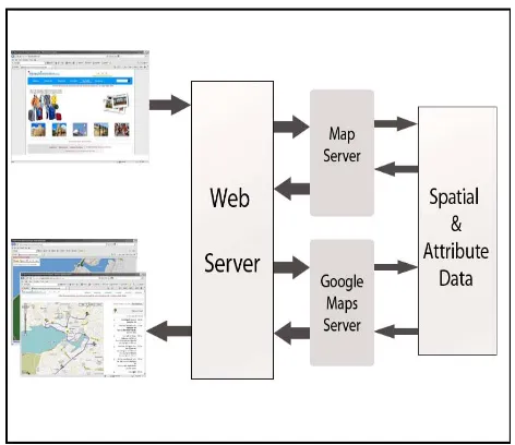
All methods are targeted at creating geospatially relevant data and creation of a web based geographic query model using Open Source GIS. Fig 1 shows the graphic representation of a geographic query model using GIS.
The user performs a request, which is transmitted to the integrated GIS system.
The GIS system queries the spatial database (which has been created and uploaded to a Web Site) to get the map data and to create a list of tourism objects which are located in the queried area and fulfill the criteria.
Each object returned will be completed with tourism data like historical places, scenic spots, hotels, travel facilities and required directions, etc.
Afterwards the transformation module converts the characteristics into the required graphic representation; maps etc according to the user query and need.
Figure 1: Functioning of a Web GIS based Query model
5.1.1 Collecting Data
The Primal step to be taken for building the tourist information system consisted of gathering the data related to the target area. This data was collected and categorized as:
Spatial data – related to the data that is in pictorial form and covers space related information of the target area.
Spatial Data Preparation:
Layers such as tourist spots, hotels and services are prepared as a point layer. Roads as line layer, and
Tourist spots, boundary etc as polygon layer.
Attribute data – the supporting data in the form of text and numbers that provides the factual information of the target area.
Data regarding all relevant spots were collected.
This data was assigned as attribute data to the spatial information.
5.1.2 Digitizing Data
The collected spatial and attribute data of the target area were processed using OS GIS software to digitize data and create shape files of multiple layers needed for the tourism information system.
5.1.3 Integrating and processing GIS Data and Setting up a Website
A web portal was created titled: www.bhopaltouristinfo.com.
The shape files created were uploaded to the site via mapserver application which was used to display the needed geographic area.
Google API program were also used to integrate the Google database and provide querying abilities to the website which are provided by Google for free.
Thus simplifying the GIS technology by integrating low cost and free GIS development tools to provide spatial / non-spatial data available to the end user. The integration and processing of the data has been done with the help of Open Source data to make the project on a low cost displaying the scope of OS GIS to make a Web-GIS Portal
5.2 Creation of GIS data in QGIS:
5.2.1 Geo-registration of Bhopal topographic sheets using QGIS
Quantum GIS V.1.5 has been used to register the topo-sheets and geo-reference the target area image. 5.2.2 Digitization and creating Shape files of the target area- Bhopal using QGIS
Quantum GIS V.1.5 has been used to create shape Files and digitize layers
5.3. Creating a website for publishing the GIS data on web
A website named www.bhopaltouristinfo.com has been created through which the GIS data is to be displayed. Adobe dream weaver has been used to develop the site.
Basic HTML pages and java scripting has been used in providing textual information of Bhopal.
5.4 Creation and Uploading MapServer data
Mapserver V- 5.6.5 has been used to export and instate the shape files to the website so that the layered data can be accessed via mapserver and displayed on the site.
5.5 Other free Web-GIS resources- Google Earth API
Google API source codes and applets have been used to enhance the user query capabilities for the Web GIS portal.
6. Results
6.1 GIS database created
All the Spatial and Attribute data were successfully collected and a GIS database was created with it required for the tourism information system.
6.1 1Creating GIS data using OS GIS
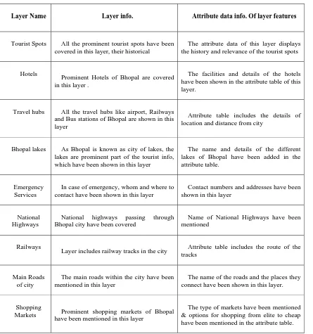
Table 1: Layers created for tourist information system
Layer Name Layer info. Attribute data info. Of layer features
Tourist Spots All the prominent tourist spots have been covered in this layer, their historical
The attribute data of this layer displays the history and relevance of the tourist spots
Hotels
Prominent Hotels of Bhopal are covered in this layer .
The facilities and details of the hotels have been shown in the attribute table of this layer.
Travel hubs All the travel hubs like airport, Railways and Bus stations of Bhopal are shown in this layer
Attribute table includes the details of location and distance from city
Bhopal lakes As Bhopal is known as city of lakes, the lakes are prominent part of the tourist info, which have been shown in this layer
The name and details of the different lakes of Bhopal have been added in the attribute table.
Emergency Services
In case of emergency, whom and where to contact have been shown in this layer
Contact numbers and addresses have been shown in this layer
National Highways
National highways passing through Bhopal city have been covered
Name of National Highways have been mentioned
Railways
Layer includes railway tracks in the city Attribute table includes the route of the tracks
Main Roads of city
The main roads within the city have been mentioned in this layer
The name of the roads and the places they connect have been shown in this layer.
Shopping
Markets Prominent shopping markets of Bhopal have been mentioned in this layer
The type of markets have been mentioned & options for shopping from elite to cheap have been mentioned in the attribute table.
6.2. Geo-referenced and digitized data:
QGIS was first used to digitize Cartosat Satellite Image (as mentioned in chapter 6) and then multiple Shapefiles were created with reference to it using GPS co-ordinates and Google earth data.
Based on the table 1, GIS data layers have been created.
The multiple layers together provide the information required for the tourist info.
These layers can be loaded together and viewed in respect to each other or loaded individually.
Figure 2: Geo-Referenced and digitized data in QGIS
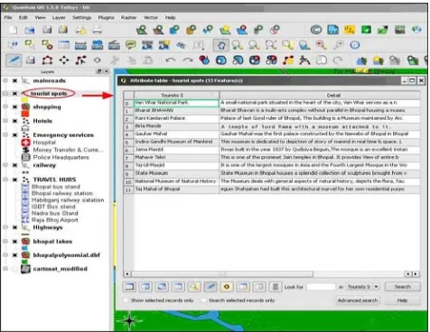
6.3 Attribute table in QGIS window.
All the layers have attribute layers attached with it which can be accessed/ seen by going to menu>layer>Open attribute table. Thus the attribute table for the layer opens up in QGIS. Fig.3 shows an example of an open attribute table for features in the layer -Tourist Spots layer, all attribute information of the tourist spots in Bhopal are visible in the table.
Figure 3: Attribute data created with QGIS
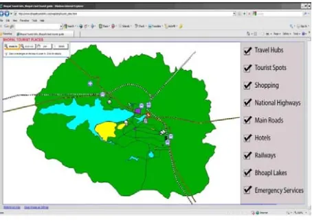
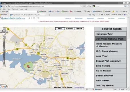
6.4 Cost Effective Web GIS Portal Created
Figure 4: Web-GIS enabled portal
6.5 OS GIS based GIS server used to display data
GIS data was uploaded on internet and using OS GIS based Mapserver, shapefiles were displayed on the internet for free which could be accessed by users. Figure 5 shows the uploaded shapefile displayed with the help of Mapserver. The data from the shapefiles are called by mapserver and displayed in the form of pictures on the web according to the user query. If the user checks on all the layers, the Website will show the all the layers together and if the particular layers are selected, only their data will be displayed on the site.
Fig 5: GIS data displayed in the website with the help of MAPserver.
6.6 Free Google Map resources were used to provide Geographical Query Support and directional
Support capabilities:
Web-GIS Features Provided:
1. Network Analysis and Directions:
Figure 6: Directions provided for tourist
The data called is used to perform network analysis and show route by creating a new layer overlaying the existing layers of spatial data.
It also accesses Google Map database and analyses the estimated time taken and directions to reach the destination.
2. Point of Interest locator :
It can also be used to search for tourist places, emergency service locator, location of hotels, finding more info about a point of interest etc.
Figure 7: Tourist spots and location finder
7) Conclusion:
1. For Tourist database, GIS is an efficient tool for the cost effective collection, storage and analysis tasks.
2. In any project, for the developing countries like India, cost is the primary consideration for the adaptability of GIS technology. Under these circumstances, QGIS Provides all the data storage and analysis for free
environment for the tourism industry. This can be very helpful in the promotion of tourism in India. As a tourist planning to visit a specific place can get all the details from the web based portal
4. Some other tools are also helpful in the customization of GIS functionalities, If required for a specific task. Ex – Google Image API. Offers a wide variety of modification and quey handling modules that can be incorporated into a WebGIS portal to increase its effect.
5. The Important point is that without investment, a person can use GIS with the help of OS GIS.
Suggestions and Future recommendations:
This project is just an example of how OS GIS can provide capabilities and features of Commercial GIS software and hoe a full fledged Project can be made using the capabilities of OS GIS
The methods and software used in this project along with other similar OS GIS software can be used to develop any project in any field at an ultra low cost
Thus the example set here can be taken as a guide to develop low cost GIS projects and promote the capabilities of GIS so that it can be accessible to the masses with a budget constraint.
The Importance and features of Open Source GIS should be promoted among the students and teachers.
Training and workshops to promote OS GIS capabilities can create awareness among the GIS community regarding OS GIS.
A consultancy or a core group can be set up that guides and assists GIS developers in using OS GIS thus generating revenue by providing consultancy and also leading to development of Low cost GIS projects and increasing profitability to the developers.
Providing low cost GIS means the permeability of the technology among the masses increases and this will lead to tapping up the capabilities of GIS to its full extent.
References:
[1] Ahmad Jamil,'Let’s dance with open source GIS'
[2] Ake Dan, ‘GIS and the Tourism Industry’, PPT for SEDA -Council of Governments, An Overview of Free and Open Source Desktop GIS (FOS-GIS):
[3] Buchanan Todd R., ‘Comparison Of Geographic Information System Software (Arcgis 9.0 And Grass 6.0): Implementation And Case Study’ A Thesis Presented to the Graduate Faculty of the Fort Hays State University.
[4] Cavallini, Paolo (2007). ‘Free GIS desktop and analyses: QuantumGIS, the easy way’. The Global Geospatial Magazine. [5] DeMers Michael N.,2009, "Gis For Dummies" Publication- WIley Publication, Inc.
[6] Gilberto Camara, Harlan Onssrud,.(2004),'Open Source GIS Software: Myths and Realities' [7] Guyette Wayne, ‘The State of Tourism/GIS Education and a Solution'
[8] Jakob Normark,(2008),'GIS-Using open source or commercial products' [9] Jayaraman Jaishankar, 'Business GIS-tourism industry-A study' [10] Longmatey Daniel et al., 2003, 'Management And Promotion Of Tourism'
[11] Mahmoud Refaat Nasr,(2007),'Open Source Software: The use of Opens Source GIS Software and its impact on organizations' [12] Ólafsdóttir et al.,2009 'A GIS Approach to Evaluating Ecological Sensitivity for Tourism Development in Fragile Environments.’ A
Case Study from SE Iceland',Scandinavian Journal of Hospitality and Tourism.
[13] Ramachandra T. V. et al.,(2004),'Geographic Resources Decision Support System – an Open Source GIS', Geospatial Today, September-October, 2004, Vol. 3(3), pp. 52-59, Hyderabad, India
[14] Ramsey Paul,(2007), ‘The State of Open Source GIS' [15] Shojaee Davod,'Using GIS And Application For Tourism',
[16] STEINIGER STEFAN and BOCHER ERWAN,(2008) 'An Overview on Current Free and Open Source Desktop GIS Developments' Publication - Int. J. of Geographical Information Science