Elements of Monsoon Circulation and its Behavior
Impact over Pakistan
ARIF ZUBAIR A.FARHAN KHAN MUHAMMAD UMER KHAN Department of Environmental Science Federal Urdu University of Arts, Sciences and Technology Karachi, Pakistan
Abstract:
This study explores the relationship of global and local elements of monsoon (pre detectors) such as Tibetan anticyclone over Himalayas, higher pressure over Indian ocean (IOHP), southern oscillation index (SOI), El Nino / southern oscillation (ESO), northward shifting of westerly sub-tropical Jet (STJ), tropical easterly jet (TEJ) etc. which significantly correlate with the Pakistan monsoon rainfall. The present paper will discuss the impact of monsoon from the normal or even slight deviations in the light of country economics, agricultural production, water availability, hydroelectric power generation, etc.
Key words: Monsoon, Pakistan, Dynamic, Prediction, Impact.
Introduction
The Arabic-origin word “mausam” refers to "weather" in Hindi, and several other North Indian languages. The definition includes major wind systems that change direction seasonally. This change of season is accompanied by a reversal of the prevailing wind direction and abrupt changes in rainfall patterns. In general, the term monsoon means a striking transformation in unrelenting wind path according to season. Major portion of the rainfall generally occurs during summer. Most summer rainfall is associated with synoptic disturbances that propagate throughout the region. However, these disturbances are grouped in periods lasting from 2 to 4 weeks. Such envelopes of disturbed weather and heavy rainfall are referred to as ‘active periods of the monsoon’. The intervening periods of mini drought are referred to as ‘monsoon breaks’.
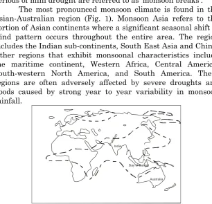
The most pronounced monsoon climate is found in the Asian-Australian region (Fig. 1). Monsoon Asia refers to the portion of Asian continents where a significant seasonal shift of wind pattern occurs throughout the entire area. The region includes the Indian sub-continents, South East Asia and China. Other regions that exhibit monsoonal characteristics include the maritime continent, Western Africa, Central America, South-western North America, and South America. These regions are often adversely affected by severe droughts and floods caused by strong year to year variability in monsoon rainfall.
Pak ista
n
India
Bay of Bangal
Australia
Asian Monsoon
The features of monsoon climate are the seasonal change of wind, the humid summer and the dry winter. In a world-wide context, there are many regions which have monsoon climate. It is known that the Indian monsoon region is more dominant than others. In the Asian region, summer monsoon starts to develop from mid-May and continues till September or October, and has much rainfall followed by lower winds. It develops as a result of the features of continental space structure, formation of low pressure gauge, convergence in lower layer due to the existence of lower atmospheric inflow from ocean, increase in humidity, with an increase in precipitation, during winter, and vice versa.
The Asian monsoons are broadly composed of three interlink components:
1. The East Asian, 2. The South Asian and
3. The South East Asian monsoon
Being a key element of the global system, the Asian monsoon influences most of the tropics and subtropics of the Eastern Hemispheres (Webster et al. 1998). There is also evidence that the monsoon may influence the atmosphere circulation in the extra tropics. The Asian summer monsoon displays a pronounced variability on a wide range of time scales from intra-seasonal to inter-annual and inter-decadal (Chang and Krishnamurti 1987; Fein and Stephens 1987; Webster et al. 1998). Joshi et al. (1988) noted the differential heating of the continents and the adjoining ocean to be the primary cause of the summer monsoon circulation over South Asia.
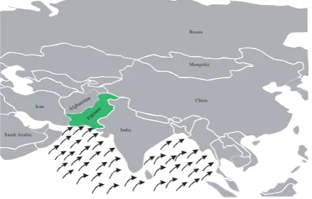
He et al. (1987) characterized the Asian summer monsoon by two successive monsoon onsets: i.e., middle May over Southeast Asia, and early June over Indian Sub-continents. Here we can say that generally there are two monsoon circulations (Fig. 2a and 2b):
a. Summer monsoon b. Winter monsoon
India
Paki stan
China Russia
Mongolia
Saudi Arabia
Iran Afghanista n
Fig. 2a: Winter monsoon of the region, northeasterly wind flow.
India
Paki stan
China Russia
Mongolia
Saudi Arabia
Iran Afghan istan
Fig. 2b: Summer monsoon of the region, southwesterly wind flow
Subsequent are major features in both winter and summer monsoon (Surfraz 2007):
The low-pressure area is typically formed as a belt-shaped zone, and is called the monsoon trough. Monsoon troughs are characteristically linked with low-level convergence and cyclonic vorticity, and cloudiness.
The wind speeds between the high-pressure area and the monsoon trough are frequently concentrated into a jet pattern. This is referred to as a monsoon jet, monsoon surge, a low-level jet, or a cross equatorial jet. Features associated with the jet typically have local characteristics.
The monsoonal circulation has vertical arrangement. The increasing air along the monsoon trough diverges out of a higher tropospheric anticyclone along an upper-level jet-like flow.
Taking into account these features, Ramage (1971) and Hastenrath (1994) define monsoonal indices to developed and determine which areas of the world actually experience monsoons. These indices typically estimate the monsoonal area on the basis of following parameters:
The prevailing wind direction changes by at least 1200 between January and July.
The average frequency of prevailing wind in January and July should exceed by 40%.
The mean resultant winds in at least one of the months should exceed 3 m/sec.
Fewer than one cyclone - anticyclone alteration should occur every two years in either month in 5° Latitude-longitude grids.
Pakistan lies in the southwest Asia with a lofty plateau to the north and the vast Arabian Sea to the south. The Tropic of Cancer passes immediately south of the country. The entirety of this region lies approximately between the terrestrial latitude 23.5 o N to 40 o N and longitude 60 o E to 80 o E. The plains of Pakistan, drained by the river Indus and its tributaries, are surrounded by many mountain ranges, scattered in the west and the southwest along the coast. The hilly terrain of Pakistan has an average height of 600m above the mean sea level. Politically, it is divided into four provinces
1. The Punjab 2. Sindh
3. Baluchistan, and 4. Khyber Pakhtunkhwa
The major part of the southern plains of Pakistan is almost arid, as reflected by the spatial distribution of mean annual rainfall, which varies from 50mm in the southwest to 500m in northern sub-mountainous areas. A rainfall of 1000 mm or more is received only over a small area in the north, along the famous Himalayan range, claiming the highest peaks in the world. The arid region and desert of Pakistan, together with the northwest of India, are considered as the eastern limit over South Asia of the word’s largest dry region, running from the Atlantic Ocean of China and Mongolia and covering portions of the two continents of Africa and Asia.
Apart from the aspect of aridity to semi-aridity, a large part of Pakistan is characterized by a large spatial and temporal variability in other climatic parameters too. In fact, the orographic features of Pakistan wield a great influence on its climate and there are peculiarities resulting from its geographical location. It lies on the western fringe of monsoon depression, on the northern edge of southwest monsoon current over the subcontinent, and forms the peripheral region of western disturbances, traveling from the far west. The western fringes of active monsoon depressions during the southwest season contribute considerably to the rainfall over the eastern plains, while the western disturbances and other circulation systems, mostly active in winter and in the transitions epoch of pre-monsoon, are the main sources of precipitation over western parts. The tropical cyclones in the Arabian Sea along the coast, which are not as frequent as those in the Bay of Bengal (lying in the east-south of the Pakistan-India subcontinent) often contribute to some rainfall in the southern parts of country (Pant and Kumar 1997).
Country coastal climate is confined to a narrow strip along the coast in the south, while the north is dominated by mountainous climate. In between, the climate is broadly of the typical sub-continental nature. In the central plains, the temperatures are very high. Jacobabad in Sindh province is credited with the highest recorded landmass air temperature of 52 o C in Asia, this being the next to the highest temperature in the world viz. 58 o C Azizia, Libya (NOAA 2008).
As far as large climate variations are concerned, there are indications that Pakistan has had its share in this. These are known to have taken place over northwest India in the past, during the Holecene (Bryson and Murray 1977). The spatial shifts in the rainfall pattern, the dominant component of climate variation, are associated with fluctuation in the general circulation of atmosphere in this region. Some of these fluctuations happen to be related to those in the mid-tropospheric circumpolar westerlies.
Trends of Monsoon
They confirmed it by the APT (Automatic Picture Transmission) data and TOVS (TIROS Operational vertical sounder) data. They further showed that most of the time the precipitation-inducing monsoon cloud systems are the outcome of the Bay of Bengal depressions, which move inland over India into the monsoon trough. Their direction of travel towards Pakistan depends on the blocking high over India. Such blocking high can be determined with TOVS 850, 700, and 500 hPa dry / moist geo-potential height charts. The chance of rain-bearing monsoon systems reaching Pakistan also depends on their intensity and the extent of low pressure over Pakistan.
The intensity is manifested on APT infrared images as whiteness, indicating the cloudiness of cloud top temperature. As monsoon systems are governed by tropical factors, the cloudiness of cloud tops is directly related to their thickness and height (Webster 1987), which is in turn indicative of their intensity and the precipitation they provide. Thus in an APT infrared image a deep white cloud during summer (April to October) over Pakistan invariably means precipitation (Haq et al. 1997). Further information confirming the cloud thickness may be obtained from the daytime APT visible images, wherein the cloud thickness is proportional to its whiteness (Haq et al., 1997).
Turkmenistan
Iran
Afghanistan
China
Jammu & Kashmir
Pakista n
India
Arabian Sea Karachi
(A)
(B)
(C)
Fig. 3: A Schematic presentation of monsoon flow in term of heavier and more frequent in Pakistan (A > B > C).
monsoonal systems coming from the east to Pakistan is along either of the following directions:
i. Bengal-Punjab-Kashmir-Khyber Pakhtunkhwa
ii. Orissa-Madhya Prdesh-Rajasthan to lower Punjab-upper Baluchistan-Khyber Pakhtunkhwa in Pakistan, and
iii. Orissa-Madhya Prdesh-Gujarat-Kutch to Sindh and Baluchistan.
iv. Other type of monsoon flow in Pakistan is also possible. Satellite study reported that if the intra-tropical convergence zone (ITCZ) moves northward to high latitude (above 15º N), may induce rain-bearing Arabian Sea depression off the coast of Kathiawar peninsula (in India). It is also observed that if the surface pressure over Sindh is low, such depression over Gujarat / Kathiwar almost always travel towards Sindh, causing heavily rainfall in eastern Sindh and some time even in Karachi. On subsiding to its normal lower latitude path, such high-latitude ITCZ during June can leave behind cyclonic systems (as happened in 1996) which can cause damage in the form of large rain and high waves reaching the northern Arabian Sea coast of Pakistan, India and Oman.
and channels rain-bearing systems towards Sindh and the lower Punjab in Pakistan.
Basic Driving Mechanism of Monsoon
Basic driving mechanisms of the monsoon, as stated by Ramage, 1971, are:
i. Heat difference between continents and oceans.
ii. Swirl introduced to the winds by the rotation of the earth.
iii. Role of water: energy release/absorption by phase change.
Also, besides several achievable causes that have already been suggested to explain the gruffness of the inception, the subsequent parameters may also play their function in developing monsoon season: dry/moist (conditional) symmetric instability of zonal monsoon flows (Krishna and Lau 1998); a switch from one dynamical regime to the other due to seasonally changeable sea surface temperature (SST) forcing (Yano and McBride 1998); the delay of the arrangement of a thermally direct circulation, due to geostrophic balance, and linked moist baroclinic instability (Xie and Saiki 1999), and a sort of subcritical instability from the equatorial trough flow regime to the monsoon trough flow regime (Chao 2000).
Monsoon onset Dynamic
The oceans plays a critical role in the physics of earth’s climate system (Pickard and Emery 1990). How does this come about? The global temperature fields, resulting largely from solar radiation, have a definitive role in determining regional circulation systems in that they are related to the key physical properties of oceans. They are wet, have a low albedo (Peixoto and Oort 1992), have a large heat capacity, and are a fluid (James 1994). Oceans provide a perfectly wet surface whose low albedo, when unfrozen (regions far from the Arctic and Atlantic circle), makes them an excellent absorber of solar radiation. The oceans receive more than half of the energy entering the climate system.
This makes them the primary source of water vapors and heat for the atmosphere. So the world ocean is the boiler which drives the global hydrologic cycle. It also provides the bulk of thermal inertia of climate system on time scales from week to centuries. The great capacity of the oceans to store heat reduces the magnitude of the seasonal cycle in surface temperature by storing heat in summer and releasing it in winter. As the seawater is a fluid, currents in the ocean can move water over great distances and carry heat and other ocean properties from one geographic spot to another. The equator to pole energy transport by the ocean is important in reducing the poll of equator temperature gradient. The horizontal and vertical transport of energy by the ocean can also alter the nature of regional climate by controlling the local sea surface temperature (SST).
monsoon rainfall and circulation anomalies responds to the imposed SST anomalies.
Systematic difference suggests, by World Climate Research Program, 1992, that the region of Indian Ocean is hard to model, maybe because of the strong seasonal SST gradient and as a result, of the spatially steep heating gradients. There is also huge dissimilarity in the manner in which each model simulates the mechanical and heating effects of Tibetan Plateau. Starting with different initial conditions, multiple runs by ECMWF (European Center for Medium-rang Weather Forecast) models also show dispersion in the mean seasonal precipitation (Sperber and Palmer 1996). This indicates the importance of the local monsoon instabilities (Webster et. al. 1998).
Elements of Summer Monsoon
The High-Pressure area over Indian Ocean (IOHP)
Southern hemispheric circulation of the monsoon region is dominated by anticyclonic circulation around a high-pressure region off the coast of Madagascar. More often a high-pressure area is located in the south Indian Ocean roughly along 500 ºE and 300 ºS during the summer monsoon. This is also known as Mascarene high and it has got a quite significant role in the cross- equatorial flow during northern summer. It gives way to low-level Jet (LLJ) with speed between 40 and 100kts, which is well marked off the African coast.
Heat low over landmass of Pakistan and Indian sub-continent with its elongated southeastward trough
pressure forms, standing from Somalia north words across Arabia into Pakistan. Heat low is well established at the end of May/early June over Pakistan and persists over the whole seasons starting from June till the mid of September whereas Arabian Sea, Bay of Bengal and surrounding area receive strong south westerly wind.
The monsoon trough extends from heat low over Pakistan, eastwards towards the head Bay of Bengal and further towards the west pacific across Southeast Asia. The entire low pressure system is almost east-west oriented with a semi permanent well marked heat low over north Pakistan. An intense trough in its normal position provides well distributed rainfall over India. Shifting of the trough northwards shifts the rainfall belt towards north (in Pakistan). In the beginning of summer i.e. in the month of April and May solar heating leads to scorching temperature especially in southern Pakistan (Sindh and Balochistan), rises the day temperature as high as up to +40 degree Celsius. The typical geographical features of Asian continental land mass give rise to extreme thermal contrast between sea in the south and land in the north, resulting monsoon (summer and winter) by the seasonal shifting thermally produce planetary belts of pressure and wind under continental influences, which is a special feature of this part of the world.
The Tibetan anti-cyclone at 200 hpa
The Tibetan High is a large warm anticyclone located at the Tibetan Plateau in the middle or upper troposphere during the summer monsoon season. Southward shift of this high from its normal position as a result of the protrusions of the mid-latitude westerlies is seen accompanied with reduction in monsoon activity over India and neighborhood.
Northward shifting of westerly sub-tropical jet (STJ)
sub tropical westerly Jet (STJ) to the north of Himalayas. The northward shifting of STJ gives way to the more penetration and advancement of monsoon towards higher latitudes.
The Tropical easterly Jet (TEJ)
The Tropical Easterly Jet is the meteorological term referring to an upper level easterly wind that starts in late June and continues until early September. This strong flow of air that develops in the upper atmosphere during the Asian monsoon is centered around 10°N, 50-80°E and extends from South-East Asia to Africa (Diedhiou et al. 1999). The strongest development of the jet is at about 15 km above the Earth's surface with wind speeds of up to 40 m/s over the Indian Ocean (Rao et al. 2008).
The Quasi-biennial Oscillation (QBO), being major features of equatorial stratosphere
The Ouasi-biennial Oscillation (QBO) in tropical stratospheric winds is defined as a reversal of the zonal wind directions over a fixed location from easterlies to westerlies. This reversal occurs with mean periods around 26-27 months, and a range of 23 to 30 months (McCreary 1959; Ebdon 1960; Reed, et al. 1961; Hastenrath 1994).
A Low Level Jet stream (LLJ)
Other than TEJ, there is another Jet flowing intermittently over Somali coast, Arabian Sea and peninsular India. This is named as low-level Jet–LLJ. LLJ is taken to represent a narrow current in the monsoon field in the lower levels of atmosphere with wind speeds above 40-60 kts. Joseph and Raman (1966) brought out the existence of LLJ over Indian peninsula.
ITCZ (Inter Tropical Convergence Zone)
because the weather that is associated with the ITCZ over east Africa is different from what is observed over western coast of Africa. Its fluctuation is maximum over the Indian region during monsoon season. The fluctuation of ITCZ over monsoonal region was studied by Sikka and Gadgil (1980) and Gadgil (1982). According to them there are two cloud zones between 70°E and 90°E; one is the continental in the monsoon zone north of 15°N and the other being the Oceanic over the equatorial regions. Active spell of one is generally associated with the weak spells of the other and vice-versa. According to Gadgil (1982), during the onset phase of the Southwest monsoon ITCZ shifts northwards leading to the establishment of the monsoon zone. It fluctuates with monsoon zone for a period of about four weeks.
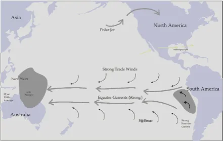
ENSO (El Nino/Southern Oscillation)
El Nino refers to much bigger semi periodic occurrence identified in full as “The El Nino/Southern Oscillation (or ENSO)”. The Southern Oscillation is a move in the relative sea surface pressure values between bigger areas of the eastern and western tropical southern pacific.
North America
South America Asia
Australia
Polar Jet
Subtropical Jet
Weak Trade Winds
Strong counter currents
Warm water
Weak Peruvian Current Pressure Decrease
Dryer Than Average
Pressure Decrease
Fig. 4a: El Nino
Opposite of an El Nino proceedings is called La Nina, and is characterized by a cooling event in the tropical eastern Pacific, resulting in the return of powerfully easterly trade wind, that flows from region of the higher to low pressure. These easterly trade winds deepened the original cooling in the eastern Pacific. La Nina occurs in sequence with a reduction in the western Pacific sea surface pressure and enhance in the Eastern Pacific sea surface pressure. This is the additional phase of the southern oscillation (Fig. 4b).
North America
South America Asia
Australia
Polar Jet
Subtropical Jet
Strong Trade Winds
Equator Currents (Strong)
Cool water
Strong Peruvian Current High Pressure
Dryer Than Average
Warm Water
Low Pressure
Fig. 4b: Normal Condition
Other features
Dr. J. Bjerknes suggests that the major drive for the Walker cell is the dissimilarity in temperatures of the Sea Surface (SST) between Indonesia (warm) and eastern Pacific Ocean (cold). Cold coastal waters off the Peru and Ecuador coasts are generated by the outpouring i.e. substitute of surface waters by colder water from greater depths. The warm SSTs at Indonesian sector persuade the better cloudiness which, in turn, cuts off the input from solar radiation, thereby reducing the drive behind Walker circulation (Das 1995). This weakening of the drive behind the Walker circulation causes the rise in SSTs at the eastern Pacific because of the lesser upwelling and resultantly the difference in western and eastern Pacific SST’s gets narrowed. Summer and winter monsoon of Asia being principal monsoon of the world appear to be dominated by the circulations that are either aligned in a north-south or east-west direction.
The performance of Asian summer monsoon is often determined by the relative importance of Hadley and Walker cells. Good monsoon appears to be associated with the more intense Hadley cell and relatively weak Walker cell, while on the other hand, poor monsoon occurs when Walker cell is strong and Hadley cell is weak.
Mid-Tropospheric Cyclones (MTC)
Offshore Vortices / Troughs
These are sub-synoptic scale systems with horizontal scale of 100-150 km and generally observed off the west coast of India during months of monsoon producing very heavy rainfall along west coast of India. Being very shallow system they are generally confined to levels below 850 hpa. They are detected by weak easterly/southerly winds at coastal stations. Offshore vortex formation takes place when southwest winds hitting the Western Ghats (mountain peaks) didn’t have enough energy to climb and tended to be deflected around mountain which results in the form of return current. Often the Offshore Trough and Offshore Vortex form off Kerala– Karnataka coast and move northward along the west coast of India. Moving northward sometimes up to northeast Arabian Sea they give birth to monsoon depression in the Arabian Sea. Southeastern coast of Pakistan’s Sindh province often receives very huge amount of rainfall with northward movement of offshore vortex/trough.
Elements of the Winter Monsoon
Surfraz 2007 characterized winter monsoon by the following quasi-permanent features:
The Siberian anti-cyclone / high pressure area
The occurrence of the Siberian Anticyclone is continuous from October until March in an area defined by longitude 90°-110°E and latitude 40°-55°N. From the point of view of central pressure, this anticyclone is much additional intense than the permanent anticyclones in the Atlantic and Pacific Oceans. For the period of the last 116 years there have been periods throughout which the anticyclone appeared stronger and periods when it appeared weaker. Since 1970 a continuous reduction in central pressure of the anticyclone is observed, and is linked to a continuous temperature rise of the 1000-500 hpa layer for the same time interval. Their association is found to be negative (Sahsamanoglou et al. 2007).
The quasi-continuous belt of low pressure lies between the subtropical high pressure belts of the Northern and Southern Hemispheres. This whole area is one of much harmonized air, perhaps the ideal barotropic region of the atmosphere. Yet humidity is so high that minor variations in steadiness cause major variations in weather. The position of the equatorial trough is fairly constant in the eastern portions of the Atlantic and Pacific, other than it varies significantly with season in the western portions of those oceans and in southern Asia and the Indian Ocean. It moves into or in the direction of the summer hemisphere. Consequently, the equatorial trough would be said to contain regions of doldrums; portions of it could be described as intertropical junction zones, and within it there might be detected intertropical fronts. Nevertheless, one flaw of this classification is that it alludes specifically and only to the survival of a trough of little pressure.
High pressure-cell over west Pacific and strong westerly sub-tropical Jet (STJ)
These jets, like the polar-front jets, are most excellent developed in winter and early spring. During summer, in the Northern Hemisphere, the subtropical jet weakens significantly, and it is only specialized in sporadic velocity streaks around the globe. Throughout winter, subtropical jets strengthen and can be found between 20° and 50° latitude. Their maximum speed approaches 300 knots, even though these higher wind speeds are associated with their combination with polar-front jets. The core is most often found between 35,000 and 40,000 feet. A subsidence movement accompanies subtropical jets and gives increase to mainly fair weather in areas they pass over. These jets are also amazingly determined from time to time, but they make change every day. From time to time they drift northward and combine with a polar-front jet. Over Asia in summer, the subtropical jet is replaced by the tropical easterly jet stream.
Most countries in Asia including Pakistan suffer from severe flood and / or droughts in summer because of the inter-annual and intra-seasonal variability of the Asian summer monsoon.
Efforts to predict the performance of the monsoon based on correlations of observed weather features have been pursued since the late 1800s. The general procedure for making these forecasts has consisted of finding suitable predictor parameters and developing regression equations based on the past data. These regression equations are then utilized to forecast the summer monsoon rainfall over India and its adjoining territory (Blanford 1884; Jagannathan 1960; Bannerjee et. al. 1978; Shukla and Paolino 1983; Shukla 1986a; Mooley and Pant 1986; Thapliyal 1987; Hastenrath 1994).
Hastenrath (1994) scheduled five major approaches in type of weather forecast:
1. The extrapolation of assumed periodicities obtainable within a data record.
2. The appraisal of statistical relations between local phenomena of interest (e.g., rainfall, pressure) and data at a few isolated phenomenons.
3. The association of the local precipitation earlier to the rainy season with precipitation at the climax of the rainy season.
4. All-inclusive analytical and experimental studies of climate and movement anomalies combined with statistical investigation, and
5. Mathematical modeling.
In addition to above following features, considered as being responsible in relation to summer monsoon rainfall are:
i. Lifecycle of the Southern Oscillation
iii. Western disturbance over western Himalaya iv. El-Nino-Southern Oscillation
In an assessment article on the inter yearly unpredictability of the Indian monsoon, Shukla (1987) recommended that the presentation of the seasonal mean monsoon determined through a statistical average of a multiplicity of independent small period fluctuations that are not linked to any seasonal or other low frequency forcing. He added that universal and planetary scale "forcing functions" that determine the inter-annual behavior of the seasonal mean monsoon circulation and rainfall, and the inter-annual variability of the small period fluctuations controlled by such large scale low frequency forcing. From this it infers those low frequency hydro dynamical instabilities of the monsoon circulations themselves that, on the one hand, apply control on the short term fluctuations described above and are, in turn, modified by the large-scale planetary controls.
There are few disagreements about the degree of predictability of the monsoons or whether they are predictable in any way. There are, actually two greatly differing schools of thought. Single assumption is that the variations of small latitude phenomena including the monsoons are the results of influences from slowly varying boundary conditions. Whereas subsequent school of thought consider that arithmetical and recreation experiments and statistical analyses of observations that anomalies in sea surface temperature and in ground albedo are competent of producing large variances. Here is slightly intense perspective that approximately something not joined straight "to the annual march of the seasons" is not predictable (Ramage 1971).
On the basis of two schools of thought, two different types of prediction can be distinguished with reference to climate and weather. Predictions of the first kind are initial value problems, exemplified by conventional weather forecast practice. Predictability of the first kind is therefore a measure of how reservations or errors in preliminary conditions intensify throughout the forecast period. By contrast, for predictions of the second kind, an effort is prepared to forecast how a system will respond to a prescribed change in one of its determining parameters. The response of climate to a doubling of carbon dioxide is an important example. Short and medium range monsoon forecasts are manifestly predictions of the first kind and are now made routinely by a number of groups around the world using state of the art numerical weather prediction models (Mohanty et al. 1994).
nonlinear dynamical system, then the two types of predictability become more intimately linked.
It is also desirable that statistical and empirical techniques for long range forecasting on monthly and seasonal scales be developed and continuously refined to produce operational long range forecasts. In fact, it is quite likely that a suitable combination of dynamical and statistical techniques would be the most appropriate way of producing operational long range forecasts.
Diagnostic studies of historical datasets have been traditionally very useful in suggesting empirical approaches to long range forecasting. Sometimes, the necessity of producing long range forecasts has compelled investigators to develop empirical relationships between different facets of the coupled atmosphere-ocean-land system, even if a plausible physical basis or such relationship is not understood. However, such empirical attempts have sometimes led to the discovery of important processes in atmosphere. A good example in this category is the work of Walker (1924), who was charged with the responsibility of producing long range forecast of monsoon rainfall over Indian sub continent. Based on some of the work of other investigators of that time and on his own intuition that the fluctuations of the Indian monsoon should be related to the world wide circulation features, he initiated a massive project of calculating correlating coefficients between monsoon rainfall and several other atmospheric circulation parameters at different locations over the world. A by-product of this effort was recognition of the extensive nature of the Southern Oscillation.
simulation of the atmosphere, represented by known physical relationships such as the equations of motion and thermodynamics etc.
Impact
The Asian summer monsoon has profound impact on social and economic activity of the south west countries and ultimately in Pakistan. The resulting impact of climate change has effect the country resources particularly agriculture, economy, water resources and energy sector, which are discuss below:
Impact of Monsoon on Agriculture
The Asian drought of 1987 was, in terms of temperature and precipitation anomalies, one of the worst of this century from Afghanistan to the Philippines. The drought was attributed to El Niño, which is statistically correlated with the type, location, and timing of the unusual weather patterns. As a result, below normal rainfall and high temperatures damaged crops and livestock throughout Asia. The International Food Policy Research Institute states in its 2009 report, “South Asia will be the most severely impacted by climate change”. By 2050 it could lose 50% of its wheat productivity (IUCN, 2009).
Pakistan is an agriculture dependent country, with over 47% of its population earning their livelihood from agriculture. It is dependant on the amount of monsoon rains, as a large part of the agricultural produce comes from the monsoon fed crops. Good monsoon always means a good harvest and brings in cheers all around country. A weak or bad monsoon is always considered as a big set back to country economy and always results in a big loss in the country GDP levels as this sector contributes 24% to GDP (IUCN, 2009). The country earns 70% of its foreign exchange from agriculture alone. Unless it maintains stable growth rates, its economy will suffer immensely.
ranking by Maplecroft of the UK (IUCN, 2009) places Pakistan the 28th amongst those that will be most severely affected. But since 22 of those countries are in Africa, Pakistan is ranked amongst the top ten outside Africa.
So, from above, it can be concluded that agriculture in the whole of the Indus Valley of Pakistan is under threat, resulting in direct and indirect impacts on agriculture that could cost billions of dollars. This threat translates into direct impacts to over 100 million people and indirect impacts to the entire burgeoning population of 180 million, which is projected to increase to 240 million by 2035 (IUCN, 2009).
Impact of Monsoon on Economy
Country might face serious economic crisis near future due to increase in population at a much faster pace than the total food grains production. A large part of the monsoon water which is currently unutilized should be held at suitable locations for irrigation and possible power generation. Pakistan economy is vitally linked with the monsoon because of its water resources.
Monsoon rains, which sustain Pakistan economy, dictate food prices of this country. Almost two-thirds of Pakistan population survive on rain-fueled farming. A poor monsoon season could kill the early opportunity for an economic revival. According to analysts, another good monsoon after last year’s record rains rainfall in 2009 would help maintain a healthy growth rate, with consumer demand remaining strong, investment picking up and manufacturers enhancing capacity. It is expected that the overall growth is going to be good because demand from the rural sector is going to be firm.
of essential items like sugar. All this coupled together will prove to have a bad impact for the Pakistan economy.
Another thing that is worrying Pakistanis is the hydro power production that will get impacted due to poor rains. Generation of hydroelectric power from monsoon rain water has been traced over the last few decades. While hydroelectric power constitutes less then 50 % (Abida and Musharaf 2004) of power from all sources, with proper surveys and planning additional hydroelectric power projects this percentage could, perhaps, be further substantially increased. The distinct advantage of hydroelectric power over all other types of power is that its source, i.e. monsoon water, is perennial, although it shows some fluctuations from year to year.
The drought of the year 2001 has been termed as one of the worst in the history of the country and can be judged from the fact that it was the major cause behind the low economic growth rate of 2.6 % of last year. According to the figures released by the Ministry of Finance, Government of Pakistan, the drought caused a loss of Rs. 25 billion to the national exchequer in the year 2000-2001 (UNDP, 2002). The position of GDP is going to be the same in the current year as the situation has not improved to any significant level due to the prevailing drought and the aftermath of September 11, 2001.
Impact of monsoon on water resource/water reservoir
In Asia, more than a billion people could be affected by a decline in the availability of freshwater, particularly in large river basins, by 2050 (Sharma and Sharma 2007). This could occur due to glacier melting in the Himalayas, which is projected to increase flooding and rock avalanches, and which will affect water resources in the next two to three decades.
According to a report by the Intergovernmental Panel on Climate Change (IPCC, 2001) looking at the threat from climate change to human development and the environment, “only the polar icecaps hold more fresh water than the Himalayan glaciers”: “If the current trends of climate change continue, by 2030 the size of the glaciers could be reduced by as much as 80 per cent” (“Up in Smoke -- Asia and the Pacific”) (Sharma and Sharma 2007).
The Indus river basin spans parts of four countries (Afghanistan, Pakistan, India and China) in an area that is more than 30% arid, and much drier than the nearby Ganges river basin (WRI 2003). The Indus River is critical for Pakistan’s 180 million people, and irrigates 80% of its million ha of agricultural land (Rizvi 2001) and is extremely sensitive to climate change due to the high portion of its flow derived from glaciers (WWF 2007). The Himalayan glaciers provide the Indus with 70-80% of its water (Kiani 2005), the highest proportion of any river in Asia. This is double the proportion of water that they provide the Ganges (30-40%). Himalayan glaciers provide 44.8% of the water in the Upper Indus in China alone (Yang and Zhenniang 1991).
This basin is already suffering from severe water scarcity due to over extraction for agriculture, causing salt water intrusion in the delta (WRI 2003). In 1995, the Indus River already supplied much less water per person than the minimum recommended by the United Nations (UN). By 2025, it is predicted to suffer even more severe water scarcity (Revenga et al. 2000).
Many Environmental and developmental problems in Asia will be exacerbated by climate change. Under climate change, predicted rainfall increases over most of Asia, particularly during the summer monsoon, could increase flood prone areas in East Asia, South Asia and Southeast Asia. In South Asia, crop yields are predicted to fall by up to 30 per cent (Sharma and Sharma 2007), creating a very high risk of hunger in several countries.
Using a century of weather observations and complex computer models, the international team of scientists led by the National Center for Atmospheric Research (NCAR) in the United States showed that even a small increase in the sun's energy can intensify wind and rainfall patterns.
The international impacts from a lack of sufficient power are often missed when debate swirls about the price of oil and gas, and the need to control emissions as part of an effort to change climate dynamics. The energy crisis with respect to demand and supply especially exist in third world countries for the last few years. This impacts countries such as Pakistan which currently has a gap of between 5,000 and 6,000 MW between what is needed and what is available. Pakistan is currently seeing both problems, a short term (though now over 48-hours) black out in most part of the country, because of torrential downpours due to the monsoon, and a longer term national shortage of more than 6,000 MW.
Part of the problem in this part of the world is that it relies on the rains of the monsoon season to provide hydroelectric power. Thus far, in Pakistan, the monsoon has not been strong to operate one of the hydroelectric plants, that at Mangla (Paktoon Khaw province) which is producing 220 MW.
In view of the shortfall of energy, the first knee-jerk reaction came from Punjab. The state banned the use of air-conditioners in government offices, boards and corporations – despite the sweltering heat – so that eight hours of uninterrupted power could be supplied to the farm sector.
With the monsoon season less of a deluge and more of a drip, Pakistan is about to suffer under a gigantic energy shortfall which threatens only to get worse unless the rains come back in force.
Conclusion
BIBLIOGRAPHY:
Abida, T., and A.T. Musharaf. 2004. “The economic value of water and the problem of water scarcity in Pakistan.” Proceedings of the seminar on Environmental, Social and cultural impact of water scarcity in Sindh, held on 15 & 16 January.
Bannerjee, A.K., P.N. Sen, and C.R.V. Raman. 1978. “On foreshadowing southwest monsoon rainfall over India with midtropospheric circulation anomaly of April.” Indian J.Met.Hydrol. Geophy. 29: 425-431.
Bharat. R. S., and S. Devesh. 2008. “Impact of Climate Change on Water Resources and Glacier Melt and Potential Adaptations for Indian Agriculture.” Keynote Address at 33rd Indian Agricultural Universities Association, Vice Chancellors’Annual Convention held on December; 4-5, 2008.
_____________________. 2008. “Climate Change and its Effect on Agriculture”, Proceedings Page 86-101, IAUA, NASC Complex, Pusa, New Delhi, India.
Blanford H.F. 1984. “On the connexion of the Himalaya snowfall with dry winds and seasons of drought in India.”
Proceedings of the Royal Society of London 37:1–23.
Bryson, R A, and T J Murray. 1977. Climates of Hunger: Mankind and the World’s Changing Weather. Madison: University of Wisconsin Press.
Budyko M.I. 1969. “The effect of solar radiation variation on the climate of earth.” Tellus 21: 611-619.
Chang, C.P, and T.N Krishnamurti (eds). 1987. Monsoon Meteorology. Oxford University Press: Oxford.
Chao W.C. 2000. “Multiple quasi equillibria of the ITCZ and the origin of monsoon onset.” J. Atmos. Sci. 57: 641–651.
Das P. K. 1995. The monsoons. 3rd ed. New Delhi: National Book Trust.
Diedhiou, A, S Janicot, A Viltard, P de Felice, and H.Laurent. 1999. “Easterly wave regimes and associated convection over West Africa and tropical Atlantic: results from the NCEP/NCAR and ECMWF reanalyses.” Climate Dynamics
Ebdon, R. A. 1960. “Notes on the wind flow at 50 mb in tropical and subtropical regions in January 1957 and January 1958.” Quart. J. Roy. Meteor. Soc. 86: 540-542.
Fein, J. S., and P. L. Stephens. Eds. 1987. Monsoons. Wiley: New York.
Gadgil, M. 1982. “Conservation of India's living resources through biosphere reserves. “Current Science” 51: 547-550.
Haq, B. U. and P. R. Vail. 1988. Hardenbol, J. and Van Wagoner, J.G., Reply to the comments by Haq et al., Science, 241, 596–597.
Hastenrath,S., 1994. Climate Dynamics of the Tropics: An Updated Edition of Climate and Circulation of the Tropics. Kluwer Academic Publishers: Norwell, 488.
He, H., J.W. McGinnis, Z. Song and M. Yanai. 1987. “Onset of the Asian monsoon in 1979 and the Effect of the Tibetan Plateau.” Mon. Wea. Rev.115: 1966–1995.
IPCC. 2001. Climate change, the scientific basis, contribution of working Group-I to the fourth assessment report of intergovernmental panel on Climate Change (IPCC). Cambridge University Press: Cambridge; 746.
IUCN. 2009. Proceeding, workshop on 'Stabilizing Climate Change in the Himalayas' held on 04 August 2009, Nepal.
Jagannathan P. 1960. “Seasonal forecasting in India, a review.” Indian Metrological Department, Special Publication, DGO.82/650.
James, I. N. 1994: Introduction to Circulating Atmospheres. Cambridge University Press, 422.
Joseph,P.V and P.L Raman. 1966. “Existence of low-level westerly jet stream over peninsular India during July.” Indian J. Meteorol and Geophys. 407(410)
Joshi P.C., B Simons, and P.S. Desai. 1988. “Atmospheric thermal change over the Indian region prior to the monsoon onst as observed by satellite sounding data” India & Climate 10: 49-56 (1990).
Kiani K.M. 2005. “Detecting business cycle asymmetries using artificial neural networks and time series models.”
Computational Economics 26(1): 65-89.
Krishna kumar V. and K.M. Lau. 1998. “Possible role of symmetric instability in the onset and abrupt transition of the Asian monsoon.” J. Meteor. Soc. Japan 76: 363–383.
McCreary F. E. 1959. “Stratospheric winds over the tropical Pacific ocean.” Bull. Amer. Meteor. Soc. 40(7): 370.
Minoura, D, R Kawamura, and T. Matsuura. 2003. “A mechanism of the onset of the South Asian summer monsoon.”
Journal of the Meteorological society of Japan 81(3): 563—580. Mohanty, U C, K J Ramesh, KN Mohan, and K V J Potty. 1994. Variability of the Indian summer monsoon in relation to oceanic heat budget over the Indian seas.” Dyn. Atmos. Oceans 21: 1-22.
Mooley and Pant G.B., 1986. “Relationship between all India summer monsoon rain fall and locations of ridge at 500-mb level along 75o.” East. J. climate Appl. Meteor. 25: 633-640.
Nigam, S. and R.S. Lindzen. 1989. “The Sensitivity of stationary waves to variations in the basic state zonal flow.” J. Atmos. Sci. 46: 1746-1768.
NOAA. 2008. “Global Measured Extremes of Temperature and Precipitation" National Climatic Data Center, United States National Oceanic and Atmospheric Administration (NOAA), accessed 3 December 2008.
Pant, G.B., and K. Rupa Kumar. 1997. Climates of South Asia. John Wiley & Sons, Chichester, 320 pp.
Peixoto, J. P., and A. H. Oort. 1992. Physics of Climate. American Institute of Physics, 520pp.
Pickard, G. L. and W. J. Emery. 1990. Descriptive Physical Oceanography. An Introduction 5th ed. Pergamon Press, 320 pp.
Ramage, C.S., 1971. Monsoon Meteorology. Academic Press, New York.
Reed R. J, W. J. Campbell, L. A. Rasmussen and D. G. Rogers. 1961. “Evidence of the downward propagating annual wind reversal in the equatorial stratosphere.” J. Geophys. Res. 66: 813– 818.
Revenga, Brunner C. J, N. Henninger, K. Kassem, and R.Payne. 2000. Pilot Analysis of Global Ecosystems (PAGE): Freshwater Systems. World Resource Institute. Washington DC. Rizvi, M., 2001. Forecasting Water Flows in Pakistan’s Indus River. 11 May 2005. International Development Research Council. Ottawa, Canada.
Sarfaraz, 2007. Monsoon Dynamics: Its Behavioral Impact in Pakistan’s Perspective.
Shamshad K., 1988. Predicting stream flow and sediment yield for mountainous areas in northern Pakistan. Ph.D. degree in Watershed Science, Utah State University.
Sahsamanoglou, H. S, T. J. Makrogiannis, P. P. Kallimopoulos. 2007. Some aspects of the basic characteristics of the Siberian anticyclone.
Shukla, J. 1987. Interannual variability of Monsoon, In
Monsoons, edited by J.S. Fein and P.L. Stephens, 399-464. John Wiley and sons.
Shukla, J and D.A. Paolino, 1983. “The southern oscillation and long range forecasting of the summer monsoon over India.” Monthly Weather Review 111: 1830–1837.
Shukla, 1986a. “Long range forecasting of monsoons”. In Monsoons, edited by Jay S. Fein and Pamela L. Stephens, 523-547.Wiley and sons.
Sikka, D.R. and S. Gadgil. 1980. “On the maximum cloud zone and the ITCZ over India longitudes during the Southwest monsoon.” Month. Weather Rev. 108: 1840– 1853.
Sperber, K. R., and T. N.Palmer. 1996. “Interannual tropical rainfall variability in general circulation model simulations associated with the atmospheric model intercomparison project.” J. Climate 9: 2727-2750
UNDP report 2002, no. 14, Operational activities for development of Pakistan-Droughts.
Walker, G. T., 1924. “Correlation in seasonal variations of weather, X. Mem. India.” Meteor. Dept. 24: 75-131.
Webster P.J, V.O. Magana, T.N. Palmer, J. Shukla, R.A. Tomas, M. Yanai, T. Yasunari. 1998. “Monsoons: Processes, predictability and the prospects for prediction.” Journal of Geophysical Research 103: 14 451–14 510.
WWF, 2007. World’s top 10 rivers at risk. WWF International. Gland, Switzerland.
Xie, S.P and N.Saiki. 1999. “Abrupt onset and slow seasonal evolution of summer monsoon in an idealized GCM simulation.” J. Meteor. Soc. Japan 77: 949-968.
Yang and Zhenniang.1991. China’s Glacier Water Resources (in Chinese). Gansu S&T Press: Lanzhou, China.
Yanai, M., and C. Li. 1994. “Mechanism of heating and the boundary layer over the Tibetan Plateau.” Mon. Weather Rev. 122: 305– 323.
Yano, J.I., and J.L. McBride. 1998. “An aquaplanet monsoon.” J. Atmos. Sci. 55: 1373–1399.
Zubair, A., Haq Nawaz, and Asif Huassain. 2009, “Hydrochemical Interpretation of Storm water Impact of Groundwater using Factor Analysis” Journal of Environmental Protection Science 3: 96-113.
Zubair, A., Asif Hussain and Haq Nawaz. 2010. “Impact of storm water on groundwater quality below retention / detention basins." Environmental Monitoring and Assessment
162(1): 427- 437.