Technology (IJRASET)
Driver Assistance System using Pothole Detection
and Warning Method
Sudam Pawar1, Sachita Kulkarni2, Mugdha Shah3, Shubham Admuthe4, Rahul Thengadi5
1,2,3,4,5
Computer Department, Savitribai Phule Pune University
Abstract: Especially in countries like India, the road conditions are worsening due to ignorance towards developing the road. The untimely rains is the major cause of road worsening. This results in road mishaps. The following paper aims at increasing the efficiency for betterment of the road conditions.
The platform used is IBM bluemix platform. IBM Bluemix is a cloud platform as a service (PaaS) developed by IBM. It supports several programming languages and services as well as integrated DevOps to build, run, deploy and manage applications on the cloud. DevOps is a set of tools to achieve automation. The main idea behind the system will be to develop a “pothole detection system” wherein the system will detect the potholes as well as temperature and pollution sensing and the irregularities on road and the collected data will be sent to the server. The server will be updated each time the vehicle pass through the potholes/ irregular surface. The repository will collect the data. Notification is also given to the user about the pothole arriving. Ultrasonic sensor is being used to sense the potholes. We propose a solution for overcoming the filthy road mishaps which endangers the lives of human.
Keywords: Pothole Detection, Warnings and Notifications, IBM Bluemix Platform, Security, Management.
I. INTRODUCTION
A well maintained road is must for the well-being and the development of a country. It results in safe travelling and hence helps in avoiding accidents. Injuries and deaths by road accidents is a major issue in India and becomes a great obstruction in development. The accidents mainly cause due to bad road conditions and potholes in the road.
In this paper we have introduced a system in which a driver can accurately determine the exact location of potholes on the road thus avoiding huge mishaps and life loss. The user will also be notified as and when the pothole is on the way. Also, the authorities responsible for the maintenance of roads find it simple to determine the site of work. This system will also assist user to determine the weather conditions of the area. There is a provision in the system that will provide pollution status of the area.
This system has been developed to save money and time. As we have been looking forward to find a solution for the betterment of the developing country, the system has been developed by considering the end user requirement and hence is cost effective so that any end user can use it as and when required. This would also help the user to find the best path and hence would save his time. This system has been developed by using the well-known IBM Bluemix platform which helps the developer to build, manage and deploy with much of less time and also with the great accuracy. This platform is basically a cloud based platform.
The paper goes as follows. Firstly, it shows about the related work carried out. Then further it tells us about the technical details and the components used in the system. Then it tells us about the implementation details and the desired conclusion and the future scope of our project.
II. RELATEDWORK
The accidents due to the mishaps on roads is been an intriguing topic among the researches and hence research is been done to solve the above problem. Following are the researches which have been done till date.
In this paper [1], a stereo vision based system which detects the pothole is proposed. Stereo vision can provide an information about the size of the pothole, without using the high cost specialized laser scanners. This paper deals with the disparity calculation algorithm which is basically used for map generation which helps in detection of potholes from the quadratic road surface. This system when put on a vehicle that patrols the roads, it will be possible for us to continuously detect and also evaluate the potholes.
Technology (IJRASET)
hence adversely affects vehicle which rides on it. The position of the system is kept at the right hand side of the desired vehicle so that all the 3 axis can be evaluated with an ease. The algorithms used are basically the data cleaning algorithm and also the pavement roughness level algorithm..
In this paper [3], Smartphones have become the basic necessity of almost every individual. It can play quiet a big role in this internetwork era. The sensing, computing and communicating capabilities of smart phones bring new possibilities for creating smart applications, including in-car mobile applications for smart cities. Using the advanced capabilities of smart phones, we refer from this paper a framework with built-in multimodal sensor analysis capability, and enables easy and rapid development of signal and image processing-based smart mobile applications. We can infer that as part of study, a sample mobile application is also developed to demonstrate the applicability of the framework. In this study, a multimodal sensor analysis framework is developed for in-car mobile applications for performing analysis on real-time synchronized sensor values. The mobile application developed within this framework detects the potholes and speed bumps on the road, and successfully extracts the image and video section corresponding to this road segment automatically. This extracted section is prepared for further image processing. The detection is shared over a central application with other drivers, which provides a quick awareness about traffic events. This application is used for detecting defects on the road, such as potholes and speed bumps, and it automatically extracts the video section and the image of the corresponding road segment containing the defect. Upon such critical hazard detection, the application instantly informs nearby users about the incident. In this paper [4], the acceleration sensor are used to identify potholes through changes in the vertical accelerometers readings and can also determine the variations in the car speed though change in horizontal acceleration. This is used in seven taxies running in the Boston area to build mobile network system called Pothole Patrol. In which each of the seven taxi needed running Linux, WiFi card for transmitting collected data, 3-axis accelerometer.
There are 3 general problem concerning the above system. First is the huge number of events such as unexpected swerves, doors being knocked, traffic jam. The second problem being the system can’t identify between the pothole and bump in the road. The third problem is that the values reported by sensors depend on the car’s speed and how the sensors are being mounted on the car.
Recently, the Jaguar and Land Rover automaker announced that they are researching a new connected vehicular technology, which allows a vehicle to spot dangerous potholes on the road and then share data in real time with other vehicles and road authorities.
III.TECHNICALDETAILS
The basic idea behind the designing of the system is to help the desired authorities in finding about the condition of the road and the maintaining it for the same. This system also helps in safe driving and hence avoiding the accidents. The driver can himself find the best path using which he can travel safely and can also save time of travelling using the road which has less number of potholes. This also becomes handy for the user and can use it anywhere and at any time.
The scope of the system is to basically develop a prototype application that includes 1. A Mobile application for the driver. 2. Easy Potholes Detection. 3. A notification in the form of warnings generated. 4. Updation of present condition of pothole on map.
IV.COMPONENTSUSEDINTHEPROPOSEDSYSTEM
The above solution proposed is a cost effective solution for detecting potholes on road. The components used in the proposed solution are as follows:
A. PIC16F877A Microcontroller B. HC-SR04 Ultrasonic Sensor C. HC-05 Bluetooth
Technology (IJRASET)
The data sensed by the sensor is collected and kept in the database. The sensors check if the potholes are present. The readings are taken after the vehicle passes through the potholes. The GPS locations are traced. The data is interpreted by the server and the data file is maintained. After this, the ETL process (software filter) is carried out following which again the data is updated. When a person logins to the application, the information regarding potholes is fetched from the server. The user gets the details on the application.
VI.ARCHITECTURALDETAILS
Development of front end is done on Android studio with Java language. We have used NetBeans for the server connectivity. The server we have worked on is Glassfish server. Here, backend is done using SQL. As the potholes are detected, the server gets the readings. The map is updated with locations after the detection.
The below are the screenshots of our application. It basically shows the pinned location of the potholes on map and also the data been received when the pothole is detected.
FIG:MAP SHOWING POTHOLES
Technology (IJRASET)
VII.EXPERIMENTALRESULTS
[image:5.612.196.418.131.295.2]The model is as shown in the figure below. The model has been tested in real time by fixing on bike. The tests was carried out in two phases. Firstly, the potholes are detected and the readings are updated on server and then the location of the pothole is pinned on the map. Then, the notification is been generated. This notification generated helps the user about the upcoming pothole.
Fig: Model of the Proposed System
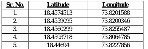
The below table depicts the information collected about the potholes. It basically shows the readings such as the longitude and latitude of the potholes detected ion the road. These further been updated as per the condition of the pothole.
Sr. No. Latitude Longitude
1. 18.4574513 73.8201588
2. 18.4559095 73.8200346
3. 18.4560299 73.8255487
4. 18.4593718 73.8064785
5. 18.44694 73.8227856
Table I: Information about the potholes collected in the simulated test environment.
VIII. CONCLUSION
This system, pothole detection and warning system is basically to detect the potholes on road and warn the user about the same. This also notifies the user about the upcoming pothole. This would also help the road management authorities to see where the pothole are and manage the road.
Further, we can also click images of potholes along with detecting of potholes. This project can be further expanded by using satellites for clicking pictures on the potholes and humps. Instead of using sensors, we can also use quadcopter for detection of irregularities and potholes on road.
REFERENCES
[1] “An Efficient Algorithm for Pothole Detection Using Stereo Vision”, Zhen Zhang, Xiao Ai, C. K. Chan and Naim Dahnoun, IEEE International Conference on Acoustic, Speech and Signal Processing, 2014
[2] “Road Condition Monitoring Using On-board Three axis Accelerometer and GPS Sensor”, Kongyang Chen, Mingming Lu, Xiaopeng Fan, Mingming Wei, and Jinwu Wu, 6th International ICST Conference on Communications and Networking in China, 2011
[3] “Automatic Detection and Notification of Potholes and Humps on Roads to Aid Drivers”, Rajeshwari Madli1, Santosh Hebbar2, Praveenraj Pattar3, G.V.Prasad4 Department of Computer Science and Engineering B.M.S. College of Engineering, Bangalore 560019, India.
[image:5.612.184.433.357.440.2]