Available Online at www.ijpret.com 1412
INTERNATIONAL JOURNAL OF PURE AND
APPLIED RESEARCH IN ENGINEERING AND
TECHNOLOGY
A PATH FOR HORIZING YOUR INNOVATIVE WORK
ROAD DETECTION AND TRACKING THROUGH PATH PLANNING FOR UAVS
MR V. R. RAUT, PROF Y. M. KURWADE, DR V. M .THAKARE
SGBAU, Amravati, India.
Accepted Date: 15/03/2016; Published Date: 01/05/2016
\
0
Abstract: An Unmanned Aerial vehicle (UAV) has many application in a variety of fields. Detection and tracking of a specific road in UAV videos play an important role in automatic UAVs navigation, traffic monitoring, and ground vehicle tracking etc. The task of UAV path planning in some cases be addressed using Sequential Monte Carlo (SMC) simulation. If sufficient a priori information about the objective and the environment is available, an assessment of the future state of the target is obtained by the SMC simulation. The assessment of path planning is also performed using S2 path planning algorithm which include “what-if” simulations to balance different alternative UAV paths. Simulated Annealing algorithm is also used for path planning, the objective of this algorithm is to find flight paths to allow UAVs to inspect numerous point of interest (POI) placed over a region considering that these points may belong to different kinds and should be inspected by specific type of UAV, which help to generate path planning for UAVs. In this paper, the proposed path planning algorithm is efficient for calculating specified path of road network through UAV videos and provide absolute path for tracking roads in UAVs navigation.
Keywords: S2 path planning, what if simulation, Simulated Annealing algorithm, TVFG, LVFG etc.
Corresponding Author: MR V. R. RAUT Access Online On:
www.ijpret.com
How to Cite This Article:
Available Online at www.ijpret.com 1413 INTRODUCTION
The Path planning for multiple unmanned air vehicles (UAVs) to cooperatively track ground targets is an important study topic with approaches varying from classical optimal trajectory planning to bio-inspired swarm behaviour. In this paper author has studied a novel UAV routing algorithm with an obstacle avoidance strategy. The algorithm combines the tangent vector field guidance (TVFG) path-planning approach with the Lyapunov vector field guidance (LVFG) algorithm to obtain a theoretically shortest path with UAV operational constraints given a target position and the current UAV dynamic state. This hybrid algorithm, called tangent-plus-Lyapunov vector field guidance (T+LVFG), has the advantage of the TVFG when UAV is outside the standoff circle and presents the ability to follow the path via the LVFG when inside the standoff circle .In this paper , two methods for path planning of a UAV were suggested and compared.
The two methods were:
Exhaustive Search and
Off-Line Simulation-aided search
Available Online at www.ijpret.com 1414 To prevent from such threats, author has consider a design, modeling, and evaluation of the cost-efficient UAS tracking system in a public space. The author has proposed to design a distributed sensor network (DSN) system for tracking UAS under a fixed budget. The system considers use of different types of sensors and test that combined use of heterogeneous sensors can enhance cost-efficiency and its performance. The system aims to track UAS flying over the crowd rather than those flying in vacant areas. Thus, aim to discover the cost-efficient configurations of sensors in a designated area that can track small UAS by laying more importance on performance at most informative areas. Agent-Based Modeling (ABM) is used to find best configurations with heterogeneous sensors that can qualify a certain requirements. This paper presents efficient and robust algorithms for ellipse detection, ellipse tracking, and single-circle-based position estimation. These algorithms are potentially applicable to a broad range of vision-based tasks such as takeoff and landing, target tracking, following visual serving and formation control as long as circles are used as the visual features. There are generally two approaches to image tracking: 1) filtering and data association and 2) target representation and localization. The first approach usually relies on Kalman or particle filtering techniques.
II) BACKGROUND
Available Online at www.ijpret.com 1415 is applied and a new set of simulations are started. In the study of UAVs path planning two possible strategies could be adopted while searching the shortest paths for the UAVs to carry the inspection. The Lucas Behnck et al. [3] has proposed the first strategy would be to specify that each UAV must check only the POI which he is better suited to. The POI type is represented by its color, and so do the UAVs. The resulting paths are in agreement with the enunciated strategy, the blue UAV visits all the blue POIs and the yellow UAV visits all the fair POI. In this strategy, it may happen that a UAV may flight to regions which are already going to be visited by another UAV. Another option would be to turn the matching between POI and UAV into a soft constraint. On this situation, a UAV would be allowed to eventually inspect one or more POI of a different nature if it results in a much smaller traveled distance. In this paper Sangmi Shin et al. [4] has consider two different types of radars in a sensor system for Agent Based Modeling(ABM) simulation this are : a) higher initial, operation, and maintenance cost with wider detection range and b) lower initial, operation, and maintenance cost with shorter detection range. These two kinds of radars are dispersed across the park. All radars have a network communication ability in order to track a target constantly when it flies through one detection region to the other. Ellipse detection has been extensively investigated based on Hough transform, ellipse fitting, is a very efficient method to find an ellipse for a given contour. However, ellipse fitting is not able to tell whether the fitted ellipse is a correct or a false detection. There are generally two approaches to image tracking: a) filtering and data association and b) target representation and localization. The first approach usually relies on Kalman or particle filtering techniques. In UAV applications, both the approach can give reliable tracking performance with the assistance of other motion sensors.
This paper introduces methods to obtain a the shortest path with UAV operational constraints given a target position and the current UAV dynamic state, this are Tangent vector field guidance (TVFG) path-planning approach ,Lyapunov vector field guidance (LVFG) , Exhaustive Search , Off-Line Simulation-aided search, Simulated Annealing solution and Agent Based Modelling (ABM). Section I Introduction. Section II discusses Background. Section III discusses previous work. Section IV discuss existing methodologies. Section V discusses attributes and parameters and how these are affected on images. Section VI anticipated method and outcome result possible. Finally section VII conclude this review paper.
III) PREVIOUS WORK DONE
Available Online at www.ijpret.com 1416 stable limit cycle centered around the target position. The UAV is implicit to be able to move freely but only in the direction of its orientation. In TVFG Hongda Chen et al. [1] has proposed a dynamic path-planning algorithm for a UAV that was tracking a ground target. A theoretically optimal path based on the TVFG was derived with UAV operational constraints given a target position and the current UAV kinematic state. The restriction of TVFG is that the UAV must be outside the standoff circle; otherwise, a departure line does not exist, and the TVFG cannot provide proper guidance for path planning.
The Farzad Kamrani et al. [2] has studied Simulation technique to use the geography of the road network, along with the latest estimation of the target’s location and the current location of the UAV. The best path is updated using the path chosen by “what-if” simulations. These changes affect only the path of the UAV after the UAV has reached the next check point. If there is no constraint on the path of the UAV, then the set of all possible paths through the area of responsibility is infinite and the problem is intractable in its general form. It is reasonable to assume that changing the path rapidly between different road segments worsen the overall performance and in general it is better to finish surveillance of a road segment before starting the surveillance of a new one. In the Simulated Annealing technique, the solutions are represented by arrays containing the POIs to be visited by each UAV. The order of these POI inside the array correspond to the order which the POI will be visited by the UAVs two initial paths are created by putting all the available POI into the corresponding UAV path, matching their types and specialty. At each iteration, a POI from a path may be moved into another path. This move has the objective to disrupt the homogeneity of the POIs, deliberately causing mismatches between POI and UAV. The other move is to simply swap two POI from one of the paths. The Lucas Behnck et al. [3] has proposed a move used in the Simulated Annealing algorithm applied for the classical TSP problem and has the goal to improve one traveller path decreasing the travelled distance.
Available Online at www.ijpret.com 1417 IV) EXISTING METHODOLOGIES
The author has studied various different method to find the path for UAV navigation this are Tangent vector field guidance (TVFG) path-planning approach ,Lyapunov vector field guidance (LVFG) , Exhaustive Search , Off-Line Simulation-aided search, Simulated Annealing solution and Agent Based Modelling (ABM). The algorithm of path planning using symbiotic simulation gives a road network, the initial location of the UAV , an a priori estimation of the location and velocity of the target, this algorithm runs “what if” simulations to determine which alternative path is the best one to be traversed in the next period.
S2 path planning algorithm
The main loop of the algorithm is repeated until the mission is ended as shown in algorithm 1. If the UAV is not at a check point, the if block is omitted. The estimation of the location of the target in one time unit later is predicted by using target’s movement model, i.e. using sampling stage in PF. The new location of the UAV is registered, sensors are read, and the estimation of the target’s location is updated using this new sensor information.
Available Online at www.ijpret.com 1418 Algorithm 1: S2 path planning algorithm
Collected and our picture of the state of the system is updated. The other part is a set of “what-if” simulations that are initiated and executed periodically and after reaching time check points. These simulations run faster than real-time and are executed in their own thread. Comparing these simulation outputs determines the best course of action.
“What if simulations” algorithm
The UAV can traverse the road segments in two directions. If the number of road segments in the area of responsibility is N, and each UAV path is combined of K road segments (in average), number of different paths is (2 * N)K, which grows exponentially in size of K. Another heuristic that decreases the size of the search space is that there is no use in starting the search from road segments with a low probability of existence of the target. Hence, it is sufficient to compare only the first one or two road segments of different paths and choose the best one.
Available Online at www.ijpret.com 1419 Algorithm 2 : "what-if" simulations
These simulations are run in the loop as shown in algo 2 to simulate the reality between time = check point and time = end of the mission.
V) ANALYSIS AND DISCUSSION
The TVFG and LVFG path planning simulation results using a point-mass approximation of the target predicted pdf and choosing a desired UAV location based on maximizing the probability of detecting the target. The two plots show the corresponding tracking results via the particle simulation strategy. In each planning step Hongda Chen et al. [1] has generate 100 particles for the predicted target location and select 50 destination candidates uniformly in the UAV’s reachable region. At each planning cycle select the UAV destination based on maximizing the probability of detecting the target. Finally, evaluate the obstacle-avoidance strategies in the dynamic path-planning algorithm. The optimal paths are plotted for different hypothetical target positions, where obstacles are successfully avoided in each planned path.
Available Online at www.ijpret.com 1420 In Simulated Annealing technique the Lucas Behnck et al. [3] has given a solutions that are represented by arrays containing the POIs to be visited by each UAV. The order of these POI inside the array correspond to the order which the POI will be visited by the UAVs, as represented on Equations 1 and 2, where xi and yi represents the POI belonging to each path and N1 and N2 represents the number of POIs on each path.
P1 = [x1 x2 xi ... xN1]... (1)
P2 = [y1 y2 yi ... yN2] ...(2)
The energy of each solution is given by Equation 3
Energy(P1, P2,m1,m2) =(m1_ + 1) N1−1 _i=1 dist(xi, xi+1) + (m2_ + 1) N2−1 _i=1 dist(yi, yi+1)... (3)
Where m1 and m2 represents the number of mismatches between POI and UAV in each path, is a penalty factor to be set before the optimization, dist(a, b) is the function which measures the distance between two POI .
Graph 1: Average solution energy and execution time for a scenario with 25pois employing 2 and 5 inspection UAVs.
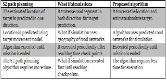
Available Online at www.ijpret.com 1421 Table 1: Comparisons between Algorithms
In this paper Sangmi Shin et al. [4] has studied the cost-efficient sensor configurations for detecting small UAS in a public place. The comparison between the algorithms is shown in Table 1 which shows the precision of this algorithm for path calculations. The simulation was designed that 1) the budget cannot cover the whole surveillance area and 2) penalties are given when the UAS above the densely populated area is not detected. The ABM method enabled modeling the nonlinear flight patterns of recreational UAS and heterogeneous types of sensors in the simulation.
The efficiency of the algorithms has been tested on laptop. The Shiyu Zhao et al. [5] has proposed the computational capability of the laptop is similar to the onboard vision computer. The proposed algorithms are used to process 100 consecutive images captured by the onboard camera in the competition. The size of each image is 640 × 480 pixels.
VI) PROPOSED METHODOLOGY
Available Online at www.ijpret.com 1422 Flowchart 1: Road path planning Flowchart for UAVs
Road tracking and planning is performed for the best path that can be derived from road detection phase. In path planning approach predicted road location is identified and processed to get the path for autonomous navigation. Each road location is classified according to incoming road predictions i.e. strait path , slightly curved path ,semi curved path and full curved path etc.
Available Online at www.ijpret.com 1423 Algorithm 3: Path planning algorithm
OUTCOME POSSIBLE RESULT
The path planning approach, gives us a final path alignment for absolute road identification in UAV navigation. Each frame is identified from video dataset to get the path for every strait path, slightly curved path, semi curved path and full curved path etc. This approach will increases the efficiency of UAV for road tracking using absolute path navigation which help for autonomous navigation of UAVs in future.
VII) CONCLUSION:
Available Online at www.ijpret.com 1424 to the suggested symbiotic simulation path planning is to employ this method in more complex scenarios involving more than one target and/or more than one UAV. Another interesting problem arises if the scenario is more dynamic, e.g. if the target reacts depending on the chosen UAV path. The proposed path planning algorithm provides absolute path, so that the chosen UAV now reacts in correct way then the symbiotic path planning approach.
VIII) FUTURE SCOPE:
From Observation, the focus is on the collaboration of multiple UAVs in a multiple target environment for future work, the propose algorithm are more suitable for providing absolute path for UAV navigation which can also help for multiple UAVs path planning and tracking.
REFERENCES:
1. Hongda Chen, Kuochu Chang and Craig S. Agate “UAV Path Planning with Tangent-plus-Lyapunov Vector Field Guidance and Obstacle Avoidance” IEEE Transactions on Aerospace And Electronic Systems, Vol. 49, No. 2, April 2013.
2. Farzad Kamrani and Rassul Ayani “Using On-line Simulation for Adaptive Path Planning of UAVs” IEEE Symposium on Distributed Simulation and Real-Time Applications, VOL. 10, NO. 9, PP. 1550-6525, September 2012.
3. Lucas P. Behnck, Dionisio Doering, Carlos Eduardo Pereira and Achim Rettberg “A Modified Simulated Annealing Algorithm for SUAVs Path Planning” International Federation of Automatic Control, VOL. 48, NO. 10, PP. 63-68, August 2015.