PARTICIPATORY DEVELOPMENT OF THE HAMLET KIRCHBÜHL,
SWITZERLAND
Melanie LIENHARD
Lucerne University of Applied Sciences and Arts (HSLU), Institute of Business and Regional Economics, SWITZERLAND [email protected]
Stefan KUNZ
Lucerne University of Applied Sciences and Arts (HSLU), Institute of Architecture, SWITZERLAND [email protected]
Stephan KÄPPELI
Lucerne University of Applied Sciences and Arts (HSLU), Institute of Business and Regional Economics, SWITZERLAND [email protected]
DOI: http://doi.org/10.23740/TID220182
ABSTRACT
The traditional settlement structure of many Swiss regions was typically characterised by dispersed small settlements, providing an important basis for agriculture. As industrialisation and structural change have accelerated, these hamlets are increasingly losing their original purpose. However, many of them are of high value in terms of their building culture and heritage. Trying to preserve them adequately presents both architectural and socio-economic challenges. In order to address these difficulties, we developed a new strategy for the hamlet of Kirchbühl, in the town of Sempach. By bringing together experts’ viewpoints and the viewpoints of the key stakeholders in a participatory process, we aimed to identify potential conflicts between the different views and address them early on in the development of new guidelines. For each work-package, the goals were defined with the aim of formulating a set of principles and recommendations for planners, builders and the public authorities. The results of the participatory elements have shown that it was possible to integrate the local viewpoints continuously into the ongoing process and the guidelines. A clear line of conflict emerged between the practical vision of the owners and inhabitants and a more preservationist vision of some authorities. Thus, a more direct dialogue between the local stakeholders and the experts should be aimed for in future projects. The ex-post process reflection has also shown that the process needs to be tightened financially and temporally, to be able to carry it out in other municipalities.
Keywords: participatory development, hamlet, stakeholders, property owners, inhabitants, heritage
INTRODUCTION
A tendency, which has continued over the last decade. Consequently, many hamlets are increasingly losing their original purpose and have seen their use altered or have been abandoned.
However, many of these hamlets are of extremely high value in terms of their building culture and heritage. Trying to preserve them adequately presents a challenge, not only on an architectural level, but also on a socio-economic level. As agricultural uses are no longer economically viable, barns are derived of their original purpose and are often left empty. Finding conversion possibilities and new uses that are in line with planning and preservation laws and offer a useful, as well as profitable alternative, presents a strong challenge. Similarly, the original farmhouses, which can be found in the hamlets, are considered beautiful by residents and visitors alike, but mostly they do not conform to modern living requirements. For historical reasons, such as the technical building possibilities at the time, the windows are often very small, allowing very little natural daylight to reach the rooms and the room-sizes are considerably smaller than in modern-day buildings. All of this makes it hard to sell or rent out these houses. Furthermore, pursuing renovations or a new-building involves numerous restrictions and long negotiation processes with heritage agencies, ensuring for example that the choice of the new building materials is appropriate (Hasche, 2006), all of which raises the costs incurred, meaning that many owners are reluctant to take action. Lastly, on a national level, urban planning challenges arise, as dispersed settlement structures do not conform to the modern day efforts of trying to promote urban intensification.
All of this makes it increasingly difficult to open up possibilities that allow the inhabitants and property owners to keep the original hamlet structures alive, while at the same time preserving their heritage. In order to solve this apparent dilemma, we developed a new strategy for the hamlet of Kirchbühl, in the town of Sempach, in Central Switzerland (see Figures 1-2).
Figure 1: Location of Sempach Figure 2: The hamlet of Kirchbühl in Switzerland and its surroundings Source: Own map based on vector data, 2017 Source: Own map based on data from the official cadastral survey, 2017
It is one of the most prestigious hamlets in Central Switzerland, in terms of its cultural heritage value. The heart of the hamlet is formed by the Church of St. Martin, which dates back to late Roman times in the 12th and 13th century. Furthermore, many old farmhouses and three barns
Figure 3: The hamlet of Kirchbühl and surrounding landscape
Source: Timo Walker, HSLU, 2017
Figure 4: Traditional farmhouse in Kirchbühl
Source: Timo Walker, HSLU, 2017
Figure 5: The church of St. Martin in Kirchbühl
Source: Timo Walker, HSLU, 2017
involved as well as a description of the participatory elements of the process. In the section results and discussion, we show the whole process in a summarised form and then outline the results of the participatory elements in detail, giving the local stakeholders’ responses and comments, as well as discussing how these were integrated into the project results. In this section, we also present the results of an ex-post process evaluation carried out with the various stakeholders that were involved in the process, as well as within the project team itself. We conclude by reflecting the need for participatory aspects, the transferability of the process and by giving a general outlook on the next steps.
THEORETICAL FRAMEWORK
Building on the discourses of Lefebvre’s “The Production of Space” (1991), scholars such as Ronneberger (2008) and Rolshoven (2012) have suggested that space ought to be considered as a triad, where the built environment is one dimension, but where representational space and experienced space are equal dimensions. Representational space refers to the historical attributions and experienced space refers to an individual’s perceptions of and everyday actions in space. All three dimensions exist together and make up space as we experience it. Thus, our modern understanding of space calls for a more participatory approach to spatial development, in order to account for all three dimensions of the triad. This is also the approach that has been taken in this project and which underlies our methodology outlined in the following section. As García (2018) puts it, “[t]o allow for change, and perhaps even to accommodate it, contemporary planners seek to engage and understand community members and make policies with local interests in mind” (p. 522). This paradigm change raises very practical questions for planners, policy makers, and local authorities as to how local interests can and should be determined, who ought to be engaged, and how to go about it. And, perhaps even more crucially, how the engagement is reflected in the final, binding plans, documents or policies. Stephenson (2010) argues very strongly that there should be “an integrative approach” in planning, “to fill the theoretical void in the treatment of people–place relations”, and to “account […] for both the rational and non-rational qualities of place/landscape across both insider and outsider value sets” (p. 19).
(2018) even points out that the heritage label is often (mis)used to marginalize and displace historic communities. All the while, scholars have long pointed to the fact that “heritage is […] subjective in its nature, representing the values of a certain group of people at a certain period of time” and that it “can easily be manipulated to favour particular interests” (Haselsberger, 2011, p. 158). The questions of “who defines what should be protected, and who decides which artefacts are to be remembered or forgotten over the years?” (Haselsberger, 2011, p. 159) are therefore critical.
Mualam & Alterman (2018) propose an interesting conceptual framework, which suggests that “there are two points of view addressing the question of heritage policy and its social impact” and that “both their implications can be recognized in decision-making processes” (p. 484). They show how heritage policy is described as “socially supportive” by some scholars and as “socially regressive” by others (p. 485). By analysing numerous cases of heritage appeals in the Greater London Area they find that “the prominence of social considerations in heritage debates suggests that heritage policies can (and do) shape the social fabric” and that “planners should be more cognizant of the potentially regressive aspects of heritage policy as it relates to society. Reliance on largely architectural discourse is no longer tenable and is likely to be challenged politically or legally” (p. 495). They state that both the socially supportive and socially regressive arguments should be taken into consideration.
Looking therefore at the wealth of theoretical groundwork and empirical findings, which suggest that our built environment is not limited simply to its physical manifestations and that built heritage is in fact a highly dynamic good, which is closely interwoven with social dimensions, we chose to develop a methodology that would allow us to both expand the understanding of the place as such, and reflect the social impacts of future development options for the locality. In order to highlight this side of the project, the paper focuses particularly on the participatory aspects, discussing the role that these have played in the spatial development process for the hamlet of Kirchbühl.
METHODOLOGY
Figure 6: Methodology for the Kirchbühl project
Work-packages constituting the methodology
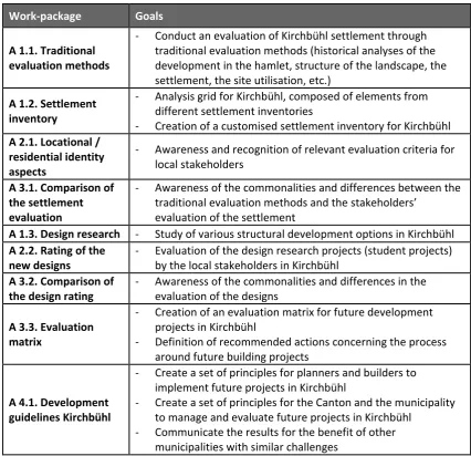
Table 1 shows the various work-packages (A 1.1. to A 4.1.) that make up the methodology of the project. For each work-package, specific goals were defined, with the aim of ultimately being able to formulate a set of principles and recommendations for both planners and builders and the public authorities, as well as extracting lessons, which could be of use for similar processes in other localities. The sequence of the work-packages is defined by chronological factors and the logic of “embedded design research”, according to which “design[s] […] are presented as arguments for interpretation by their intended audience, forming a critical triad of discourse” (Faste & Faste, 2012, p. 6).
Table 1: Project work-packages and associated goals
Work-package Goals
A 1.1. Traditional evaluation methods
- Conduct an evaluation of Kirchbühl settlement through traditional evaluation methods (historical analyses of the development in the hamlet, structure of the landscape, the settlement, the site utilisation, etc.)
A 1.2. Settlement inventory
- Analysis grid for Kirchbühl, composed of elements from different settlement inventories
- Creation of a customised settlement inventory for Kirchbühl A 2.1. Locational /
residential identity aspects
- Awareness and recognition of relevant evaluation criteria for local stakeholders
A 3.1. Comparison of the settlement evaluation
- Awareness of the commonalities and differences between the traditional evaluation methods and the stakeholders’
evaluation of the settlement
A 1.3. Design research - Study of various structural development options in Kirchbühl A 2.2. Rating of the
new designs - Evaluation of the design research projects (student projects) by the local stakeholders in Kirchbühl A 3.2. Comparison of
the design rating - Awareness of the commonalities and differences in the evaluation of the designs A 3.3. Evaluation
matrix
- Creation of an evaluation matrix for future development projects in Kirchbühl
- Definition of recommended actions concerning the process around future building projects
A 4.1. Development guidelines Kirchbühl
- Create a set of principles for planners and builders to implement future projects in Kirchbühl
- Create a set of principles for the Canton and the municipality to manage and evaluate future projects in Kirchbühl
- Communicate the results for the benefit of other municipalities with similar challenges
Involved stakeholder groups
Steering group
The project steering group was composed of a town councillor of the city of Sempach, a member of the cantonal heritage agency (Denkmalpflege und Archäologie), and a member of the cantonal urban planning department (Raum und Wirtschaft), as well as the project team from the Lucerne University of Applied Sciences and Arts (HSLU).
Property owners and inhabitants of Kirchbühl
The property owners as well as the inhabitants of Kirchbühl were involved in a number of ways, which we shall focus on later in the paper. The hamlet of Kirchbühl has around 60 inhabitants in total, including the children. Around 15 of these are also owners of a property and / or land. Hence, the absolute number of people to be included in the participatory process was relatively modest.
Further stakeholder groups
Next to the main stakeholder groups listed above, some stakeholders were involved selectively through talks or meetings. This included a local planning office which regularly consults the town of Sempach, the old-town commission (Altstadtkommission) of the city of Sempach – an expert body, which acts as an advisory committee for the town council for all questions relating to architecture and construction, the town council (Stadtrat), and the architecture students of the University of Applied Sciences and Arts. They were tasked with developing designs for the hamlet of Kirchbühl and in particular for a currently unused barn, which is in the possession of the town.
Workshops and interviews with the property owners and inhabitants of Kirchbühl
As can be seen from Figure 6 and Table 1, the participatory aspects of the project concern particularly work packages A 2.1. “Locational / residential identity aspects” and A 2.2. “Rating of the new designs”. Even though they comprise the smaller part of the whole project, they involved a number of steps, which shall be outlined in the following section. Specifically two workshops, as well as telephone interviews, which were carried out between March and September 2017. The results were continuously integrated into the remaining work-packages (A 3.1. – 4.1.).
Workshop 1
The first workshop was carried out in March 2017 and was attended by 30 people. The main goal of the first workshop was to determine the principal elements that the property owners and the inhabitants of Kirchbühl deem relevant for the character and the identity of the hamlet. After an introduction into the project and the goals, the following questions were discussed with the participants in detail, in three smaller groups:1
- What represents Kirchbühl for you?
- What do you think about when talking about Kirchbühl (including social, natural / environmental and built aspects)?
- What does “keeping Kirchbühl alive” mean for you?
The participants were initially asked to write down important elements on large post-it notes by themselves. Later, the notes were collected and discussed in the groups.
In the second part of the workshop, the participants were asked to individually rate the importance of the following statements on a scale of 1 to 5, “1” being the highest priority and “5” the lowest:
- The use of built elements in the surroundings and interventions to the terrain level are to be kept minimal;
- New builds, conversions, and extensions should adopt existing styles, inclinations, and materials for the roofs;
- Paved areas are to be reduced to a minimum, matched to the terrain, and not sealed; - The buildings should have clearly structured timber facades, made from local timber in
brown or grey tones;
- Parking spaces should be integrated into the buildings;
- The arrangement of the windows should follow the (local) context through a steady and uniform collocation;
- New builds, conversions, and extensions follow the local context in terms of scale and form;
- For old buildings, balconies are avoided, for new builds they are integrated into the building;
- The block foundation is solid and built with mineral materials (natural stone, concrete, plaster).
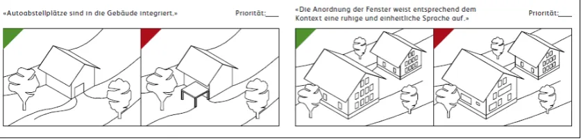
In order to clarify some of the specific architectural vocabulary the statements were accompanied by illustrations, showing which ways of building would conform or not conform to the respective statements. Figure 7 shows an extract of the rating sheet that was distributed to the participants. At the top, the statement was spelled out, on the right side a blank was placed for attributing the personal priority rating and below illustrations showed good and bad practice according to the statement.
Figure 7: Extract from the rating sheet distributed to participants of the first workshop
Source: HSLU
Telephone interviews with the property owners in Kirchbühl
After a short introduction of the interviewer and the project, the following questions were asked:
- How long have you been a property owner in Kirchbühl? How long have you lived in Kirchbühl?
- In your view, what are the strengths of the locality? (e.g. good location, views, green spaces, ….)
- In your view, what are the weaknesses of the locality? (e.g. noise from the motorway, no public transport connection, empty barns, …)
- Do you have development plans for your property in the coming years? If yes, what are they aiming at? (e.g. Conversion? Extension? Residential use? Commercial use? What time frame are you aiming for, for the completion?)
- What is your personal focus for your property?
o Maintenance and repair (without an improvement / gain in quality) o Renewal, repair or extension (with improvement / gain in quality) o Keeping the property as a capital investment
o No plans (maybe selling or moving out)
- If you currently have no development plans, what about the long-term (the next 10-15 years)?
- Do you have any further concerns, which you think must be considered for the further development of Kirchbühl, so that the current qualities can be maintained?
The results of the first workshop and the telephone interviews were incorporated into the elaboration of the development guidelines for Kirchbühl (A 4.1. “Development guidelines Kirchbühl”), and were used as indicative information for the task assignment for students’ projects (A 1.3. “Design research”).
Workshop 2
The second workshop took place in September 2017 and was attended by 18 people. The main goals were to determine in which direction the development principles for the hamlet should go, ranging from more general considerations about the scale and types of uses to more concrete regulation questions regarding traffic and parking in the hamlet. In the first part of the workshop, a target image was presented, with four different sections, concerning the positioning of the hamlet as a living environment, the architectural development, and the use of formerly agricultural buildings, such as the barns. Furthermore, it contained elements outlining a target for the population development and the townscape of the hamlet. The participants were asked to read the sections for themselves and write down on posters the comments they had. Subsequently, an open discussion was initiated to deepen the comments brought up by the participants.
In the second part of the workshop, the following questions were discussed with the participants, and rated individually by them on large posters:
- Which population scenario do you prefer for Kirchbühl?
o Status Quo (60 inhabitants) o Moderate growth (80 inhabitants) o Doubling (120 inhabitants)
- Which type of use do you see the most for the barns in the hamlet?
o Agricultural o Commercial o Residential
o Agricultural and commercial o Agricultural and residential o Residential and commercial
o Agricultural and commercial and residential
- Could you imagine the following use for the barns in Kirchbühl?
o Parking
o Infrastructure in combination with another use
- Should the current ban on driving through Kirchbühl be enforced more severely? - Would you approve of the introduction of a 20 km/h zone?
- Should future parking spaces in the hamlet be organised centrally or in a decentralised manner?
- Should there be a future restriction on the number of parking spaces per dwelling unit? - How important is it to you to have centrally organised guest parking at the entrance to the
hamlet?
- How important is it to you to have a mobility concept for Kirchbühl? - How do you rate the following ideas?
o Regeneration of the fountain square
o Community space that can be rented out, for example for wedding receptions.
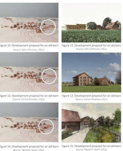
At this stage of the project, architecture students of the Lucerne University of Applied Sciences and Arts had designed a number of projects showing how the hamlet as a whole could develop and how one of the old barns, belonging to the town of Sempach, could be converted for a new use or be replaced by new buildings (see Figures 8-15).
Figure 8. Development proposal for an old barn
Source: Mario Huser, HSLU
Figure 9. Development proposal for an old barn
Figure 10. Development proposal for an old barn
Source: Selin Zihlmann, HSLU
Figure 11. Development proposal for an old barn
Source: Selin Zihlmann, HSLU
Figure 12. Development proposal for an old barn
Source: Carine Amacker, HSLU Figure 13. Development proposal for an old barnSource: Carine Amacker, HSLU
Figure 14. Development proposal for an old barn
Source: Qendrim Gashi, HSLU
Figure 15. Development proposal for an old barn
Source: Qendrim Gashi, HSLU
The aim behind the student projects was to show possibilities, rather than developing a concrete project. Hence, the designs were not, as had originally been planned, rated as part of the formal workshop, but the inhabitants and property owners of Kirchbühl had the possibility to look at the designs comprised of plans, visualisations, and 3D-models and leave their comments in writing for each of them.
RESULTS AND DISCUSSION
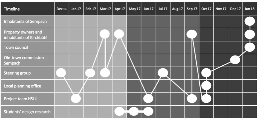
Figure 16 shows the project process in a summarised form. On the horizontal axis, we show the timeline of the project with the corresponding date of each step at the top. The vertical axis shows the involved stakeholders (inhabitants, property owners, steering group, planning office, old-town commission, etc.) and the activity of the project actors (project team, students). As the figure demonstrates, the process involved a continuous exchange and development of results between different actors and stakeholders.
Figure 16: Summarising graph of the project process and steps
Source: HSLU
Results of the participatory elements
The following section will present a summarised form of the results obtained from the participatory elements described above, and reflect upon the reception of the process among the stakeholders, as well as the integration of the results in the overall project results.
Key elements for the inhabitants and property owners
In terms of natural and environmental aspects, the close connections to nature and the views on the lake of Sempach and the nearby mountains are particularly valued. The close connection to the original agricultural activities taking place in and around the hamlet are also valued by many, though awareness of the difficulty of keeping these activities going, due to the ongoing structural change is high. In that light, it was often mentioned that it would be desirable to keep the original agricultural uses alive wherever possible, but that there is a need to remain realistic at the same time. The negatives mentioned were mostly connected to traffic. This concerns the traffic going through the hamlet on the one hand, and the noise emissions from the nearby motorway, which runs directly below the hamlet further down the hillside, on the other. Additionally, the fact that the hamlet is not served by public transport is perceived as an impediment.
Finally, in terms of aspects that concern the built environment, the historic setting is welcomed and appreciated. The Church of St. Martin as well as the old farmhouses and barns are perceived as intact and beautiful, with unique elements that make up a fitting ensemble. However, it also became clear that the inhabitants and property owners are confronted with challenges when it comes to living in these houses, or wanting to renovate them. Among the difficulties mentioned were the building features (e.g. small windows, low ceilings) and the challenges involved in renovating them, particularly dealing with constraints and obligations from the cantonal heritage agency and the longer timelines for approval, as well as the associated costs for renovations or new builds.
The evaluation of the results obtained from the rating sheet (see Fig. 7) showed that the aspects that were perceived as most important by the inhabitants and property owners were: “New builds, conversions and extensions follow the local context in terms of scale and form” and “New builds, conversions and extensions should adopt existing styles, inclinations and materials for the roofs”. This was followed by: “The block foundation is solid and built with mineral materials (natural stone, concrete, plaster)”, “The buildings should have clearly structured timber facades made from local timber in brown or grey tones” and “The use of built elements in the surroundings and interventions to the terrain level are to be kept minimal”. All other aspects, such as integrating parking spaces into the buildings, or choosing a uniform arrangement of windows were not deemed particularly important by the inhabitants and property owners of Kirchbühl.
Concerning the question of development possibilities for the barns, there was also a wider spectrum of viewpoints among the different property owners. Some stressed that new residential uses, conforming to modern living requirements, should be possible in these buildings. While others stressed, that residential uses are a possibility, but should not be exclusively applied as the sole option. Concerning the barns, it was pointed out that they pose particular challenges in being repurposed, as they usually have a very large footprint and very large roofs, which are difficult to subdivide. Additionally, the fact that the barns are disused means that they generally face structural problems more rapidly, for example as the timber frames become affected by woodworms.
In the second workshop, the inhabitants and property owners commented on a draft target image. The changes arising from the comments (in bold) were the following:
• The hamlet positions itself as a place of residence, which is attractive for different generations, instead of mainly for families.2
• New builds, which replace old buildings, have to be of high quality, and should respect the character as well as integrate the typical local elements in a contemporary form. • The types of uses that are envisioned should be primarily related to agricultural or
residential uses.3 In the first draft, possible examples of such uses were given; these
were removed, as some of them were contested. Furthermore, it was added that the uses should be compatible for the hamlet, in particular regarding the emissions and traffic they generate.
• Instead of speaking more generally of a moderate increase in population, it was defined in concrete numerical terms; i.e.: “A population increase from 60 to around 80 inhabitants is possible.”
• For the continued advancement of local relations in the hamlet, jointly used areas (e.g. multi-purpose room) are supported, instead of speaking of infrastructures.
• The section previously named townscape was changed to town- and landscape, to reflect the importance of the natural landscape for the character of the hamlet.
Additionally, the participants were asked to give their rating on a set of different questions, as outlined above (see pp. 39-40). In total, there were 18 participants, though not all chose to mark their vote on each question, hence the total number of respondents per question is sometimes below 18.
Figures 17 to 21 show the outcomes of this rating process.
2 The explicit distinction between “families” and “different generations” was crucial to the inhabitants of
Kirchbühl. They emphasised that different generations is a more inclusive term, as it encompasses, for example, young, single inhabitants or elderly inhabitants.
3 The relation to agricultural uses was understood quite broadly to include commercial activities such as
Figure 17: Results of the question on the preferred population scenario for Kirchbühl
The preferred population scenario with moderate growth from 60 to around 80 inhabitants (11 out of 15 votes) was integrated into the target image.
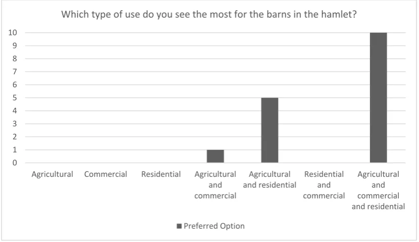
Figure 18: Results of the question on the preferred type of use for barns in Kirchbühl
For the type of use envisaged for the barns in the hamlet, there was a clear preference (10 out of 16 votes) for a mix of agricultural, commercial and residential uses.
0 1 2 3 4 5 6 7 8 9 10 11
Status Quo
(60 inhabitants) Moderate growth(80 inhabitants) (120 inhabitants)Doubling Reduction
Which population scenario do you prefer for Kirchbühl?
Preferred Option
0 1 2 3 4 5 6 7 8 9 10
Agricultural Commercial Residential Agricultural
and commercial
Agricultural
and residential Residentialand
commercial
Agricultural and commercial and residential Which type of use do you see the most for the barns in the hamlet?
Figure 19: Results of development proposals for the hamlet
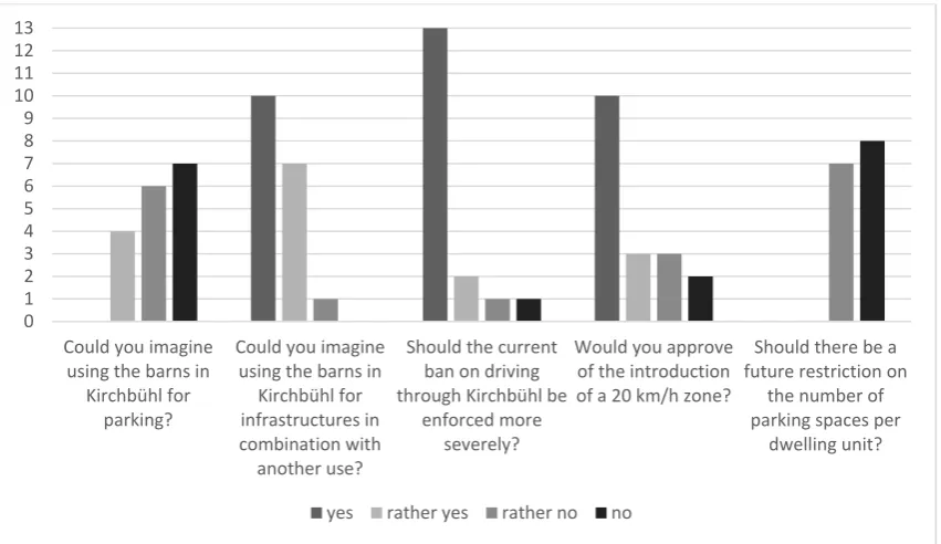
For a number of questions, the participants had to mark how much they agreed or disagreed with certain development proposals. Asked if they could imagine using the barns for parking, the majority voted “rather no” or “no” (13 out of 17). Using the barns for communal infrastructure in combination with other uses was favoured, with 17 out of 18 voting “yes” or “rather yes”. A more forceful enforcement of the current driving ban through the hamlet was approved (15 out of 17 “yes” or “rather yes”). The introduction of a 20 km/h zone was also rated mostly positively (13 out of 18 “yes” or “rather yes”). A future restriction on the number of parking spaces per dwelling unit was very clearly rejected (15 out of 15 “no” or “rather no”). Finally, the participants were asked to rate how important certain issues were to them personally, with a scale comprising the options “important”, “quite important”, “rather unimportant” and “unimportant” (see Fig. 21). The availability of centrally organised guest parking was regarded as “important” for 16 out 17 respondents. The creation of a mobility concept for Kirchbühl was contested, with 8 out of 17 perceiving it as “important” or “quite important”, and 9 out of 17 regarding it as “rather unimportant”. Similarly, the idea of a communal space which could also be rented out to external people (for e.g. for wedding receptions) was “important” or “quite important” to 11 out of 17 people, while 6 out of 17 regarded it as “rather unimportant”. Finally, 15 out of 18 people rated a regeneration of the fountain square as “important” or “quite important”.
0 1 2 3 4 5 6 7 8 9 10 11 12 13
Could you imagine using the barns in
Kirchbühl for parking?
Could you imagine using the barns in
Kirchbühl for infrastructures in combination with another use?
Should the current ban on driving through Kirchbühl be
enforced more severely?
Would you approve of the introduction of a 20 km/h zone?
Should there be a future restriction on
the number of parking spaces per
dwelling unit?
Figure 20: Results of the question on centralised versus decentralised parking solutions
The question of whether future parking spaces in the hamlet should be organised centrally, or in a decentralised manner was rather contested, with 8 out of 17 favouring a “rather centralised” solution, and 9 out 17 favouring a “rather decentralised” solution.
Figure 21: Results on the importance of different development options
0 1 2 3 4 5 6 7 8 9
Centralised Rather centralised Rather decentralised Decentralised
Should future parking spaces in the hamlet be organised centrally or in a decentralised manner?
Preferred Option
0 1 2 3 4 5 6 7 8 9 10 11 12 13 14 15 16
Availability of centrally organised guest parking at
the entrance to the hamlet
Existance of a mobility
concept for Kirchbühl Existance of a communityspace that can be rented out (e.g. for wedding
receptions)
Regeneration of the fountain square in
Kirchbühl
Commonalities and lines of conflict
We aimed to gather commonalities and potential lines of conflict between the viewpoints of the local stakeholders, such as the inhabitants, and those of the experts from the fields of planning and heritage preservation. Thus, we devised our methodology (see Fig. 6) with two parallel project strands, which come together at multiple points. Overall, highlighting commonalities and lines of conflict between the different stakeholder groups was not possible to the extent to which we originally envisaged it. This was mainly because the experts involved in the process showed little interest in attending the workshops with the inhabitants and property owners. Thus, the discussion could not be facilitated immediately, but rather had to be channelled through the project team. Nevertheless, commonalities as well as lines of conflict were noticeable and taken into account while developing the details in each step of the process and the development of the final guidelines.
Particularly the first workshop demonstrated that the inhabitants have a great appreciation for the particularity of the buildings they inhabit and own. In the rating of the important aspects to consider for renovations or new builds (see Fig. 7), we see that they consider general scale and form of the buildings, the styles, colours, and materials used, and minimising the intervention on the terrain to be essential in order to preserve the character of the hamlet. A line of conflict with the experts’ views, such as those of the cantonal heritage agency (Denkmalpflege und Archäologie), however, concerned more practical aspects, such as allowing covered external parking or balconies that stick out of the main building frame. Similarly, it became clear from the interviews with the property owners that specifications and restrictions for the interior of the buildings are less apprehended, especially in light of the fact that the hamlet should be preserved as a living space. The strong preservationist stance taken by the cantonal entity thus presented a line of conflict throughout the project.
Integration of the participatory elements in the project results
As a final project step, we elaborated so-called development guidelines (“Leitlinien für die Entwicklung”) for the hamlet of Kirchbühl. They reproduce the results of the participatory process in a consolidated form and serve as a basis for the municipality, builders, and the heritage agency in determining future development within the hamlet. In order to bring the contents of these guidelines into an official planning document and make them binding, the municipality of Sempach decided to include its contents in a structure plan for the hamlet (“Richtplan Weiler Kirchbühl”).4
The development guidelines are divided into two main sections, the first dealing with the development of the hamlet as a whole, and the second focusing on the development practices for individual buildings within the hamlet.
In the first section, the target image outlines the main directions of impact. The comments of the inhabitants and property owners on the target image, collected during the second workshop, were directly integrated as described above. Next to the target image, the first section contains indications on the development of the local building fabric in certain perimeters, indications of possible usage types for the barns, and recommendations for mobility
4 Spatial planning instruments at the municipal level include the zoning plan and the associated zoning
management. The possible usage types for the barns, as well as the recommendations on mobility are also a direct result of the discussions and feedback during the participatory process. The second section contains a process sequence for building projects, planning principles and planning recommendations. The process sequence for building projects was elaborated with the municipality by determining their existing procedures and putting them on paper in order to make them transparent to the building owners. While the planning principles were discussed with and rated by the inhabitants and property owners (Fig. 7), the priorities stated were ultimately not taken into account in the final document. Instead, all of the planning principles have been kept. Finally, the planning recommendations give some added detail on the specifications made in the planning principles.
Ex-post process reflection
After completion of the participatory process, and the elaboration of the guidelines, we carried out an ex-post analysis of the project, reflecting on the original goals internally within the project team, as well as externally with the involved stakeholders.
Project team HSLU
In order to reflect on the process that was carried out, and the potential for improvement, the project team of the Lucerne University of Applied Sciences and Arts (HSLU) held an internal workshop. A selection of the key points that were raised are described here briefly, focusing on the aspects that concern the participatory elements of the process.
The number of stakeholders involved was deemed as generally adequate; however, in hindsight, it would have been helpful to start with a comprehensive stakeholder map at the beginning of the process. This would have allowed to show dependencies between the stakeholders and delineate which stakeholders are or are not going to be actively involved in the process. Both the project team and the steering group also deemed it desirable to have workshops together with the planning and building experts. This would likely allow to better see the lines of conflict between their views and the views of the inhabitants, and potentially find solutions to these through discussion. Generally, it was found that conflicting points need to be highlighted more and raised more offensively in future processes, in order to avoid that they continue to exist subliminally and are not tackled. The fact that the process and its outcomes were strictly open-ended could also have been highlighted better.
Including the students’ projects in order to produce designs enabled the realisation of very detailed designs, which could be discussed tangibly with the various stakeholder groups. The disadvantage was that the interplay with the inhabitants and property owners, while developing the designs, was very limited. In a follow-up project, we aim to produce certain design elements, such as volumetric studies directly through the project team, so that they can be developed in cooperation with the inhabitants.
Finally, the hamlet of Kirchbühl proved to be very manageable concerning both the size of the settlement and the number of relevant stakeholders that needed to be addressed. If future projects focus on larger spatial areas, the participation methods will have to be adjusted. In light of this, a targeted, group-related process gains additional importance.
Property owners and inhabitants of Kirchbühl
At the end of the final workshop, the participants were asked to fill out a questionnaire to give feedback on how they perceived the process. While 32 people took part in the first workshop and 21 in the second, only 10 feedback forms were received at the final workshop. Hence, not all the local stakeholders’ feedback could be collected as desired.
The feedback form consisted of two parts: In the first part, seven items had to be rated on a rating scale of 1 to 5, 5 corresponding to “applicable/correct”, and 1 corresponding to “not applicable/ not correct”. In the second part, there was the possibility to comment freely in the form of written text.
Figure 22 shows the distribution of the results of the questionnaire.
Figure 22: Results of the questionnaire distributed to participants of the final workshop
In a summarised form, the results of the questionnaire made visible that points 1-3, as well as point 5 show mostly positive feedback. Hence, no direct need for action was derived from these points. Point 4 showed some slightly more negative feedback. Inside of the project team, we thus discussed options, which would allow inhabitants to voice their concerns in a less public setting. While the property owners had the possibility to do so through the interviews that were carried out with them, the inhabitants were constrained to the public workshops. Options that were discussed include a digital, anonymous questionnaire. The feedback concerning point 6 was generally more split across the rating scale. The conclusions drawn are that the results will
0 1 2 3 4 5 6
1. the process was meaningful and
necessary
2. the process was transparent
3. the concerns of my stakeholder group were collected in an
appropriate manner
4. I was able to voice my personal concerns
5. the result unites the
different interests in an
acceptable compromise
6. the guidelines bring clarity
7. it was worth taking part in
the process I am of the opinion, that ...
have to be presented in a way that focuses more on the various target groups. For example, aspects that concern property owners who want to renovate or do a rebuild could have been highlighted more clearly.
Project steering group
The members of the steering group were asked about their evaluation of the process in separate interviews. For the interviews, a questionnaire was prepared, with the following questions:
1. How did you experience the process? (short general assessment)
2. To what extent are you satisfied with the result? To what extent are you not satisfied? 3. In your view, what are the strengths of the process?
4. In your view, what are the weaknesses of the process? 5. What would you change?
6. In which cases is it worth carrying out such a process?
7. To what extent can you make use of the results in your daily practice? 8. In your opinion, which findings can be transferred on to other hamlets?
Additionally, they were also asked to complete the same feedback form as the inhabitants of Kirchbühl. The results are not shown graphically due to the lower number of respondents. Instead, the results are given in a summarised form below.
The main feedback from the steering group was that the process enabled the creation of sustainable and actionable guidelines, based on a comprehensive analysis. On the negative side, it was mentioned that the questions concerning the handling of the disused barns and the handling of hamlets in the Canton in general could not be answered as extensively as they would have liked. The extensive analyses, the inclusion of the stakeholders, as well as the design research through the architecture students were all named as strengths of the process. The weaknesses mentioned were that there had been different expectations from different stakeholders, which could not all be fulfilled, and that the communication with the local inhabitants and property owners did not manage to achieve full acceptance and understanding for the rules which limit the building possibilities within the hamlet. Furthermore, it was mentioned that the perimeter of the analyses could have been extended further.
Possible changes that were suggested concerned the continued improvement of communication and including direct contact of expert members of the steering group with the local inhabitants and stakeholders. Overall, it was also mentioned that the process could be tightened with a view of reducing time and effort. In light of this, it was mentioned that it is particularly worth carrying out such a process in settings of high heritage value and with good locational qualities, or where general development questions surrounding the locality need to be clarified, with the aim of achieving a higher settlement quality.
CONCLUSIONS
“[T]oday the processes of community engagement have come to be seen, not just as ancillary functions or even best practices, but as the very foundation of […] planning ethics. The virtual necessity of engagement today, however, has not yet produced standards for engagement practices or techniques that could be seen as universalizing or ubiquitous […]; much of the field is constrained to the art and craft of engagement, and not a rigid methodology or science” García (2018, p. 534).
Though there seems to be growing consensus on the importance of public engagement in spatial development (see above), in practice, we still find very few planning documents that thoroughly consider the role that territorial identity and “people-place connections” (Stephenson, 2010) play. Also the question of how territorial identity can be strengthened to support spatial development processes remains very limited (Stephenson, 2010). With the project in the hamlet of Kirchbühl, we aimed to address this gap.
While the aim of achieving a universal methodology or practice is somehow contrary to the iterative nature of participatory processes, where the results of each round of engagement inform the actions and the design of the next step, there is nevertheless a need to make such processes comprehensible and manageable for public entities if we want them to be applied more widely. In view of this, the aim of our applied research project was to develop a method that would make the process we carried out in Kirchbühl applicable to other municipalities, by making the elements within the larger frame customizable to the specific setting of each locality. In this article, we have seen that the main challenge arising for the Swiss traditional settlement form of the hamlet is structural change. The decrease in agricultural activity renders barns obsolete, and questions the right to existence of settlements outside the building zones in times when urban intensification is being promoted. The heritage value of many of the old farmhouses and barns goes unquestioned, yet difficulties in upkeep and long, expensive processes for maintenance and renovations pose a threat to their continued existence.
We have seen that by expanding our traditional understanding of space as a merely physical space to a multidimensional space, which includes historical attributions and individual perceptions, the need for a local perspective on space and identity is apparent. In keeping with the ideas and arguments that many scholars have put forward, we have attempted to integrate professional as well as local value sets in our methodology. The methodology combines two strands, which come together at multiple points in the process to identify potential commonalities and lines of conflict, which can also occur among experts of different disciplines or among the inhabitants. The experience of Kirchbühl has allowed us to define three rough phases which can function as a framework for applying the process of Kirchbühl to other localities. The three phases have been defined as:
• Phase 1 - Understanding comprehensively • Phase 2 - Developing collectively
• Phase 3 - Implementing qualitatively
possible and locally desired development options makes up the basis for the following steps (Fig. 6: Work-packages A 1.3, A 2.2 & A 3.2). Finally, in Phase 3, development guidelines are drafted and discussed with different stakeholders (Fig. 6: Work-packages A 3.3 & A 4.1). They provide a set of principles for planners, builders, and the local authorities.
The results of the participatory elements have shown that it was possible to integrate the local viewpoints continuously into the ongoing process, and consider the preferences that resonated with a large part of the community in the elaboration of the guidelines. Some lines of conflict with the experts’ views, such as those of the cantonal heritage agency could not be discussed in the depth that we had hoped for. Hence, the development guidelines reflect the feedback obtained from the local stakeholders to a large part, with exception of the planning principles. From the ex-post process reflection, we have seen that the process still needs to be tightened, so that it becomes feasible to carry out a similar process with less financial resources, and in a shorter time frame. In terms of the participatory aspects, a more direct dialogue between the local stakeholders and the experts should be aimed for in future projects, as well as adjusting the participation methods more to certain target groups, especially in view of potential projects that cover larger spatial areas and thus a greater number of stakeholders.
Outlook
We are now carrying out a similar process to the one in Kirchbühl for a dispersed settlement in the municipality of Giswil, Canton Obwalden. The cultural and building heritage as well as the characteristic landscape are also of high importance in this dispersed settlement. Simultaneously, we are trying to apply this framework to the scale of whole municipalities in other places around Switzerland, aiming to coordinate it with local spatial planning processes. The methodology used may be applied to other localities aiming to bring forward spatial development processes with a participatory approach. Certainly, the greatest challenge in the attempt to create a more widely applicable methodology for spatial development processes is that each locality still needs to be considered in its uniqueness, and the engagement of local stakeholder groups needs to be adjusted accordingly. Hence, the execution of the process in its “art and craft” is much more vital than the framework applied. Nevertheless, more experiences through further applied research can be gained on customisable elements for development processes in areas with high heritage value, urban intensification processes, or municipal development in general.
Acknowledgements
REFERENCES
FASTE, H., & FASTE, T. (2012). Demystifying “Design Research”: Design Is Not Research, Research Is Not Design. IDSA
Education Symposium 2012, Boston, Retrieved August 16 2018, from http://www.idsa.org/sites/default/files/Faste.pdf
FEDERAL STATISTICAL OFFICE (FSO) (2007). Schweizer Landwirtschaft Taschenstatistik 2007, Retrieved October 31
2018, from https://www.bfs.admin.ch/bfs/de/home/statistiken/kataloge-datenbanken/publikationen.assetdetail.343657.html
FEDERAL STATISTICAL OFFICE (FSO) (2018). Betriebe in der Landwirtschaft 1905 (Map-ID: 8433) & Betriebe und
Nutzfläche in der Landwirtschaft 2005 (Map-ID: 8421). Landwirtschaftliche Betriebszählung 2008. Retrieved
August 2 2018, from Statistischer Atlas der Schweiz https://www.atlas.bfs.admin.ch/maps/13/map/mapIdOnly/0_de.html
GARCÍA, I. (2018). Community Participation as a Tool for Conservation Planning and Historic Preservation: The Case
of “Community as a Campus” (CAAC). Journal of Housing and the Built Environment, 33(3), 519-537,
https://doi.org/10.1007/s10901-018-9615-4
HASCHE, K. (2006). Risiko-Objekt oder Liebhaberstück? Neue Zürcher Zeitung, March 3 2006.
HASELSBERGER, B. (2011). Setting the Scene for Future Planning: Reflections of a Young Planning Scholar. Planning
Theory & Practice, 12(1), 157-160, https://doi.org/10.1080/14649357.2011.550488
LEFEBVRE, H. (1991). The Production of Space. Malden, Oxford, Victoria: Blackwell Publishing.
MESKELL, L. (2018). Heritage, Gentrification, Participation: Remaking Urban Landscapes in the Name of Culture and
Historic Preservation. International Journal of Heritage Studies,
https://doi.org/10.1080/13527258.2018.1542334
MUALAM, N., & ALTERMAN, R. (2018). Social Dilemmas in Built-Heritage Policy: The Role of Social Considerations in
Decisions of Planning Inspectors. Journal of Housing and the Built Environment, 33(3), 481-499,
https://doi.org/10.1007/s10901-018-9610-9
POLLICE, F. (2003). The Role of Territorial Identity in Local Development Processes. Proceedings of the Conference
“The Cultural Turn in Geography”, 18-20th September 2003, Gorizia Campus. Part II: Landscape Construction
and Cultural Identity (pp. 107-117). Edizioni Università di Trieste, Retrieved August 16 2018, from
http://hdl.handle.net/10077/841
ROLSHOVEN, J. (2012). Zwischen den Dingen: der Raum. Das dynamische Raumverständnis der empirischen
Kulturwissenschaft. Schweizerisches Archiv für Volkskunde, 108, 156-169, Retrieved January 25 2017, from
https://static.uni-graz.at/fileadmin/_Persoenliche_Webseite/rolshoven_johanna/Dokumente/jr_raumverstaendnis.PDF RONNEBERGER, K. (2008). Henri Lefebvre and Urban Everyday Life – In Search of the Possible. In: Goonewardena, K.,
Kipfer, S., Milgrom, R., & Schmid, C. (eds.), Space, Difference, Everyday Life – Reading Henri Lefebvre (pp.
134-146). New York, London: Routledge.
SCHWICK, C., JAEGER, J., BERTILLER, R., & KIENAST, F. (2010). Zersiedelung der Schweiz – unaufhaltsam? Quantitative
Analyse 1935 bis 2002 und Folgerungen für die Raumplanung. Zürich: Bristol-Stiftung; Bern, Stuttgart, Vienna:
Haupt.
STEPHENSON, J. (2010). People and Place. Planning Theory & Practice, 11(1), 9-21,