This title is nowind~ed in Scopus
PLANNING MALAYSIA
Geospatial Analysis in Urban Planning Volume II (2013), Page 57 -74
FIRM DYNAMIC ANALYSIS FOR URBAN LAND USE AND ECONOMIC GROWTH MODELLING
Noordini Che' Man1, Soheil Sabri2, Nafisa Hosni3 & Harry Timmermans4
1
'2&3Centrefor Innovative Planning and Development (CiPD) UNIVERSITI TEKNOLOGI MALAYSIA
4
EINDHOVEN UNIVERSITY OF TECHNOLOGY, THE NETHERLANDS
Abstract
In urban growth processes, urbanisation is highly influenced by economic growth which triggers the dynamics of economic agents and land uses. This is consisted of complex subsystems which need sophisticated methods like agent-based modelling and simulation to understand the pattern, behaviour and scale of multiple actors. The objective of this paper is to identify the behaviour, pattern and the scale of impact of firms on market in the region in order to foster an accurate agent-based modelling. The Geographic Information System is utilized to geocode the entrance and exit of firms to the market in Greater Kuala Lumpur region. This study has also carried out a temporal analysis considering 18 years performances of the firms from 1990 to 2007. The findings in this paper show sector 9 (i.e. Financing) has highest percentage of establishment with 35.1 %. In addition, Sector 3 (i.e. Mining) and Sector 5 (i.e. Electricity) have the lowest percentage of establishment with 0.3 %. The result of this study will be a foundation to facilitate developing an agent-based modelling and simulation which helps town planners and decision makers to understand the relationship and interaction between economic growth and dynamic land use patterns in their region.
Keywords: Regional Economic Growth, Geographical Information System, Urban Sprawl, Firm Demography.
1
Senior Lecturer at Department of Urban and Regional Planning, Faculty of Built Environment, Universiti Teknologi Malaysia. Email: [email protected] (Corresponding Author)
Noordini Che' Man, Sohei/ Sabri, Najisa Hosni & Hany Ti111111er111a11s Firm Dynamic Analysis/or Urban Land Use and Economic Growth Modelling
INTRODUCTION
Urban planning and transportation modelling have in common a long history of modelling urban dynamics. These disciplines have however used to some extent different modelling approaches. The integrated land use transportation models have been dominant in transpo11ation research. The core of this modelling approach is a transportation demand model that is applied to a given spatial configuration of land uses. It results in a distribution of traffic, travel times and perhaps congestion. These travel times are then used as input to measure accessibility. Land use change is then modelled as a function of changing accessibility, and iteratively urban dynamics are then simulated.
It may be argued that the integrated land use transpo11ation models include a richer set of behavioural principles. However, the location decisions of firms which are mainly based on the concept of accessibility do little justice to the results of empirical studies in regional science and economic geography. This suggest that the location decisions of firms are part of their overall business model and influenced by a larger set of considerations, some of which are related to preferences, others to constraints. To avoid these problems, multi-agent models have been advocated as an alternative to these dominant modelling approaches. An agent in this context represents a decision maker that makes location decisions, party independently, partly in reaction to the location decisions of other agents. The philosophy behind this modelling approach is that urban growth patterns emerge as the cumulative effects of these individual decisions. In that sense, multi-agent models are assumed to better allow investigating urban land use as a complex system. Models are built in order to understand urban dynamics since these tools, in mimicking part of the urban system, can provide valuable information on the system's behaviour to planners. Despite the potential of agent-based models to simulate urban dynamics, very little progress has been made, especially if ignoring those models claiming to be multi-agent models but which in reality stay very close to conventional integrated land-use transpo11ation models. This is possibly the result of the lack of basis for identifying the characteristics of multiple actors. This paper therefore, prepares a foundation for an agent-based modelling and simulation of urban dynamics while understanding the pattern, behaviour and scale of multiple actors. The paper considers firms entrance and exit in Greater Kuala Lumpur, Malaysia, where the economic growth and urbanisation trend is rapid and attracted a great number of literature (Morshidi 2000).
In achieving sustainable development in Malaysia, urban planning activities have changed from simple objectives to a more complex exercise improving comfort living conditions. This is due to the government initiative to
PLANNING MALAYSIA
Geospatial Analysis in Urban Planning
introduce development programs to accelerate economic growth and elevate income levels to improve the quality of life of people. Furthermore, with the new trends of economic regional development in Malaysia, it may be relevant to
develop a model which simulates growth within the region. Economic growth can be described as changes or increments in the level of production of goods and services in the economy of a country over a period of time. To the extent that economic growth is reflected in urban growth, it is often manifested in changes in
land use patterns. In general, some amount of growth can be captured in the
existing building stock and associated land use patterns, but increasing growth tends to induce land use change. The problem and difficulty is how to incorporate economic growth in agent-based models. This paper aims to answer this question in the following sections.
URBAN LAND USE AND ECONOMIC GROWTH MODEL
Understanding Urban Land Use
Understanding urban and regional growth is important in order to model it since it involves several actors with different patterns of behaviour (Cheng 2003). Urban growth can be defined as the process of growth and decline of urban areas. These urbanization processes tend to be strongly linked to economic development
processes. The pattern of concentration of economic activity and its evolution has been found to be an important determinant of the structure of cities, the organization of economic activity, and national economic growth. Yet, urban
growth affects the efficiency of production and economic growth, and the way
agents interact and live in cities. Urban growth is related to land use in cities. In order to understand these land use pattern, models have been built to make these
relationships explicit.
Early urban models were formulated in the 1950s. However the first
operational model of urban land use is widely considered to be developed by
Lowry (1964) and is known as "Model of Metropolis". This model was the first generation of models that is based on theories of spatial interaction. The spatial
interaction models framework was continued to be developed through the early 1960s to the mid-1980s when they became mainly replaced by models grounded on random utility theory and an econometrics framework (Iacono et al. 2008). This shift also meant a changing focus from aggregate, spatial analysis to
disaggregate non-spatial analysis. Starting in the early 1990s, researchers have
dedicated their effort to develop comprehensive urban micro-simulation models,
and cell based models which reflect the dynamics of change in urban environments. These modern era models backed with advances in computing
Noordini Che· Man. Soheil Sabri, Naflsa l-losni & /-!any Timmermans Firm Dynamic Analysis for Urban Land Use and Economic Growth Modelling
technology and efficiency, allow researchers to undertake a more complex series of model development, for instance, through the integration of new technology such as GTS to create a new generation of models. Figure 1 shows the chronological development of land use and transportation models.
Early Models
1950 1960
. E I
Intermediate ra Models
1 Modern Era Models
LAND USE AND TRANSPORTATION MODELS
Spatial Interaction
Models
1980
I :
Agent-based Models
Cell-based Models
Micro-simulation
Models
Econometric Models
2000 Present
Time
Figure I: Chronological Development of Urban Land Use and Transportation Models
Source: Modified from Iacono el al. 2008
How to Incorporate Economic Growth?
To address the issues of incorporating economic growth in land use change model, several cellular automata and agent-based models have been develop (Batty & Xie 1994; Yeh & Li 200 L; Li & Liu 2008). Although there are differences between models, integrated land use transpo1tation and cellular automata models typically first estimate a model of economic growth such as a spatial input-output model, sometimes linked to assumptions or a model of external urban growth. These models then predict the impact of change in the economy in one sector or region on other sectors in other regions. This change is assumed to reflect a changing demand for land use. Finally, this additional demand is allocated across locations as a function of accessibility and suitability. The mechanism of including economic growth into these models is hierarchical and aggregate and far removed
PLANNING MALAYSIA Geospatial Analysis in Urban Planning
from the premise of agent-based modelling of behavioural realism. The question
then is what alternative approach may be employed?
Based on the notion that location decisions are part of their business model and its inherent dynamics, it has been argued that perhaps the demography of firms or firm demography may be valuable approach (van Wissen 2002). This concept focuses on the demographic transformation of firms in the region and its
correlation with land use changes. Firm demography can be defined in terms of the lifecycles of a firm which are similar to human lifecycles that consist of birth, death, and changes in the number of employees of the firm. Seminal work on this concept goes back to David Birch's study on 'job generating processes' in the
USA (Birch 1979). He advocates that the economic development of a region
consists of birth, death, and migration of firms which can be considered as the
basic components of development (Van Dijk & Pellenbarg 2000b ). In recent years, firm demography has caught some attention in organisational sociology (Carroll &
Hannan 2000), economics and economic geography (van Wissen 2002), industrial
organization (Geroski 1995; Audretsch et al. 1997); (Caves 1998), regional
science (Van Dijk & Pellenbarg 2000a) and transportation (Moeckel 2005). This
study decided to use the concept of firm demography, but the concept probably needs some elaboration. Existing models have basically used the concept only to have an accounting system that predicts the future number of firms in particular
segments and their size as a function of births, deaths and relocations. To the
extent these drivers of change are predicted, often again the well-known aggregate models are used. This remains far from a richer theoretical framework. Hence, the
challenge is how to model decisions about growth/decline, start and closure and
relocations as a function of external factors. Identifying the special links between
firm dynamics and urban dynamics will give firm demography the connotation of
an intermediate concept linked with economic growth.
Malaysia's Urban Planning System and Economic Growth
Urban planning activities in Malaysia has evolved from the simple objective of
improving living conditions to a more complex exercise of facilitating the achievement of sustainable development in the country. This is due to the intensity of development activities that require determining issues such as those relating to location, size and patterns of land utilization.
Table l shows Malaysia's Vision and National Planning System from the
year 1947 until now. The vision is the revolutionize government development. The
national planning development plan is a written policy document that includes
supportive statistical data to define Malaysia's terms of development and that sets
the agenda for socio economic change (Bruton 2007). This vision and
Noordini Che' Man, Soheil Sabri, Nafisa Hosni & Hany Timmermans
Firm Dynamic Analysis for Urban Land Use and Economic Growrh Modelling
development plan emphasise Malaysia planning strategies for generating sustained
economic growth to ensure that the benefits of growth can be shared among all Malaysians in an equitable manner.
T bi a e I MI a aysia . ' s y·. 1s1on an d N at. 1ona I L eve I PI anning
s
•YS em tPlan 1947-1957 1958-1970 1971-1990 1991-2000 2001-2010
Content
Vision British Old I.New I. New National
Colonial Economic Economic Economic Vision Policy Policy Policy Policy
2.0utlinc 2. Outline Perspectiv Perspectives es Plan I Plan 2
Planning Plans for Plans for Development Development Development
at Economic Economic Plans Plans Plans
National Development Development Plans 1-5 Plans 6-7 Malaysia
Level Plans 8-9
National Physical Plan
Source: Modified from Bruton (2007)
The Malaysian economy has generated an average Gross Domestic Product (GDP) of 6.2 % per annum from I 991 to 2005 and was expected to grow at a healthy rate of 8.5 % a year between 2006 until 20 I 0 (Parliament of Malaysia 2006). With the previous and cunent economic situation in the country, it explains the relation to firm performance in a later part of the paper. Although this research
is not directly related to an economic study, the economic indicators and government policy need to be taken into consideration because firm demography is influenced by these.
GIS AND ABM INTEGRATION
Currently, the employment of [nformation and Communication Technology (ICT)
is seen as an evolving approach to improve urban governance. GIS is a tool for decision making and for providing planning information. GJS tools have the ability to build complex and interesting spatial models that represent patterns of urban development, although that may take some effort as their script languages are not necessary the best in this regard. At the very least, however, geographic
information systems are highly appropriate for spatial data handling and visualization of model output (Davis 200 I). Geo-reference is the most important feature of GIS and this functionality is very useful for spatial modelling.
Applications based on spatial reference will create better agent-based models
PLANNING MALA YSlA Geosparial Analysis in Urban Planning
(Benenson & Torrens 2004). Meanwhile, agent-based model have the capability to represent the processes underlying a particular phenomenon or activities.
According to Cheng (2003), agent-based modelling (ABM) can be defined as a collection of interacting autonomous agents, each with their own capacities and goals but related to a common environment that can involve communication, such as passing of information from one agent and environment to another. He
also claims that agent-based simulation is ideally suited to explore the implications
of nonlinearity in system behaviour and also lends itself to models that are readily
scalable in scope and level. In urban systems, Multi Agents are also a useful tool
for representing mobile entities in urban environments such as people, households
and vehicles (Benenson & Torrens 2004). They have been used in urban contexts
to simulate pedestrian movement in urban environments (Kerridge et al. 2001) and
relocate households (Benenson 1998). It is unlikely that a model of urban evolution will need that level of detail, but in any case these examples of agent
-based model do indicate that these systems are more appropriate to include a wide
variety of behavioural principles and co-evolutionary decision strategies. Therefore, the relation and interaction of firm dynamic and land use changes can
be simply detected using agent-based modelling.
GIS technologies are very useful for this study because GIS allow agent-based modellers to relate agents to actual geographic locations. Therefore, the integration of GIS and ABM will enhance the capability of urban simulation
techniques (Brown et al. 2005; Parker 2005, Torrens & Benenson 2005). The
integration of ABM and GIS enables exploring how heterogeneous individual
decisions of agents translate it into aggregate rates of a phenomenon (Mathur
2007).
Integration of GIS and ABM in the urban dynamics domain has been studied before in several aspects. Gorn;alves et al. (2004) for example,
recommended a conceptual environment for coupling GIS and ABM simulation tools. Their ABM -GIS model was used to study the impact of a particular policy by modelling the behaviour of industrials under certain circumstances. A Shell for
Simulated Agent Systems (SeSAM) was developed as a tool that provides a
generic environment for modelling and experimenting in agent-based simulation
(Schille et al. 2004).
The integration of GIS and ABM would allow the simulation of urban dynamic development and has potential to simulate, display, analyze and present data using a common platform. Multi-agent models have the potential advantage that simulations can be more based on the behavioural of the actors as opposed to statistical data related to spatial units of observation. Relatively, it also will help
Noordi11i Che' Man, So/1eil Sobri, Najisa Hosni & I !any Timmermans Firm Dynamic A11c1/ysisfor Urban Land Use and Eco110111ic Growth Modelling
urban development actors (policy makers and urban planner) and other
professionals and administrators that are involved in the whole process of
implementation to understand and make a clear decision in urban planning
development.
STUDY AREA
The development of economic regions is one of the forms of the national mission
in Vision 2020 motivated by Malaysia's former Prime Minister Dr. Mahathir. The
initiative of economic development areas was inspired by the successful Klang
Valley region development which is known as the heartland of Malaysia's industry
and commerce. With diverse development concepts, it aims to achieve the goal of accelerating economic growth and development, and improving the quality of life
for the people in these regions. Five new economic development corridors
throughout the country were initiated and are being developed since 2005:
lskandar Development Region (IDR), North Corridor Economic Region (NCER),
East Corridor Economic Region (ECER) Sabah Development Corridor (SDC) and
the most recent The Sarawak Corridor of Renewable Energy (SCORE). Thus, with
these economic development regions, it is realistic to develop a model that
simulates growth within these regions. Yet, after considering data availability, it
was decided to focus on the Klang Valley region and specifically on Kuala
Lumpur as the study area.
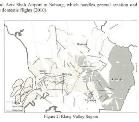
location
Klang Valley is a region in Malaysia which is comprised of Kuala Lumpur and its
fringes and neighbouring cities and towns in the state of Selangor. Klang Valley
has no official boundary, yet it is currently comprised of six districts which are
Kuala Lumpur, Putrajaya, Gombak, I-lulu Langat, Klang and Petaling (Figure 2).
The physical site of the area was encouraged by the development of commercial,
industrial and residential activities which made Klang Valley grow rapidly. With a
population of 5.78 million people (Department of Statistics Malaysia, 2008) and
areas covering up to 2,826 km2, Klang Valley has the most urbane transportation
hierarchy in Malaysia. Rather than a road system, integrated rail transport which
consists of monorail, electrified commuter, light rail transit (LRT) and Express
Rail Link (ERL) are built for Klang Valley's residents and workers to commute within the region which make it the most important region in Malaysia. This
region is also served by two airports: the Kuala Lumpur international Airport
(KUA) in Sepang, which is the main international airport for Malaysia, and Sultan
PLANNING MALAYSIA
Geospatial Analysis in Urban Planning
Abdul Aziz Shah Airport in Subang, which handles general aviation and turbo -prop domestic flights (2010).
Figure 2: Klang Valley Region
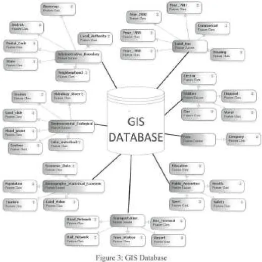
GIS DATABASE DESIGN AND DEVELOPMENT
Data Source
This study will utilize data from various sources, including GIS spatial and attribute data. The land use data of Klang Valley is obtained from Klang Valley Federal Territory (KVFT), demographic data from the Department of Statistics Malaysia and firm data which consist of companies registered in Malaysia are acquired from Company Commission of Malaysia (CCM). Other data to support the application such as transportation, administration and physical data are obtained from KVFT. The data are collected by visiting the targeted agency. In order to get accurate and precise data, every single spatial data is required to have
a standard geo-reference. Thus, the data needs to be edited and manipulated.
Attribute data were collected from various sources such as compilation of scientific reports, collections from site surveys, various digital forms data in multiple formats such as database, spreadsheet tables, and internet as well as raw
data. All these data were adapted to a standard format and stored in a relational database management system which has the ability to relate to other databases.
Noordini Che' Man, Soheil Sabri, Nafisa 1-fosni & 1-fany Timmermans Firm Dynamic Analysis for Urban Land Use and Economic Growth Modelling
Data Classification
The structure of the GIS database for this study is focused on the needs of this
study: land use development. For this study, there are several data layers in the database (Figure 3).
~
=
Ckn
=)
\(lendJNdC
Fu1 .... C.n
~~
:}\
(~~.
;)
=)
\
\
Locaf~uthortty :::Year_1999
Fuu .. aau Ft1it1nCSm
~rattve_Jlound11ry
,..,.,..D_,~
HMltok>Qy _River :::
f'•.-i.nebu
\
Elwlronmental.Jcok)olcal
, ... o.i.wt
Lelcc_wotcrbodi ~ Fut-.nebn
\
-- --
-~GIS
l
DATABASE
Yc:ar_t981
f'e1111ndm
firm
, • ....,.0111.ntl:
=)
=)
. G
~.-an,
.,..,,.oM(
~
w
.......
am-i
~!.
,
~
_
-
_
i::-
-,..
....
_··
_
·
-<
if
"::!~.
lkd_Termlnal
ft-~dus
Figure 3: GIS Database
FIRM DATA ANALYSIS
=)
=)
=)
The first stage of firm data analysis was conducted for the years 1990 until 2007. This preliminary analysis served as a guide to decide on the method that will be used for later periods of firm data.
Geocoding Firm Addresses
PLANNING MALAYSIA
Geospatial Analysis in Urban Planning
The firm data which were obtained from CCM were in spread sheet format. In
order to display firm locations in spatial environments, geocoding was used. Geocoding or address matching is the process of assigning a location, usually in the form of coordinate values, to an address by comparing the descriptive location
elements in the address to those present in the reference material (ESRl 2003). Based on the data, addresses come from common address formats of a company premise number followed by the street name, postal zone and area. Geocoding the address is based on a linear interpolation of an address based on the street segment in a reference of street file. In this study we geocode 62,605 firm addresses in the database. Addresses were geocode to the street name and assigned longitude and longitude coordinate using Kuala Lumpur street address locator which was created
using ArcGIS software version 9.2. To geocode addresses, company data were the input and road information were the key field for matching the address. Addresses were matched using a minimum score of 10, spelling sensitivity of l 0 and side offset of 10. With ArcGIS, the result of unmatched geocoding can be rechecked by using interactive re-matching function where the address can be reviewed and
corrected on a case by case basis. Results with a match rate of greater or equal (>=) were positively accurate.
Result
From the 62,605 firm in the database, a match rate of 86 % (n
=
53,626) match with score 80 to 100, 14 % (n = 8,979) match candidate with score not more than(<) 80 were discovered. From the overall matching process, 17 % (n
=
10,394) arematched with candidate ties. In general, it can be concluded that most of the geocoded address fall close to the reference data locations.
FIRM DYNAMIC AND PRODUCTIVITY
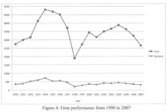
This analysis covers firms in the Kuala Lumpur area between 1990 and 2007.
Figure 4 shows the dynamic performance of firms operating between 1990 and 2007. In total, there are 62,605 firms including unknown type of firms in the
Kuala Lumpur area. An unknown type firm in this study is described as a firm which is not adequately define by CCM. As can be seen in Figure 4, there were three peak years of firm growth: 1995, 2000 and 2004. From year 1995 onwards,
the growth of new firms started to decline especially from 1997 to 1999 due to the
global financial crisis. Unknown type firms have shown a rise and decline
similarly to the trends observed for new firm's birth.
Noordini Che' Man, Solieil Sabri, Nafisa Hosni & /-/any Timmermans Firm Dynamic Analysis/or Urban Land Use and Economic Grow/Ii Modelling
5000
I
4500
4000
3500
3000
2000
1500
1000
[
00
=9~ ~92 1993 1994 1995 1996 1997 1998 1999 2000 2001 2002 2003 2004 2005 2006 2007
year
Figure 4: Firm performance from 1990 to 2007
~Firm
-+-Sectorl
The trade sector including firms, playing a role in generating output, income,
employment and foreign exchange earnings which contributed to excellent economic performance. As shown in Figure 4, from the year 1990 until 2007, the
number of births of firms increased every year in the study area. The increases of
new firms are in line with Malaysia's Business Cycle Turns between 1990 and
2007 as shown in Figure 5. The business cycle is influenced by cyclical
fluctuations in economic activities or processes, whereby these economic activities
or processes can have widely conflicting temporal relationships to the business
cycle (Department of Statistics Malaysia 2009).
PLANNING MALA YSL4 Geospatial Analysis in Urban Planning
lndeks p T p T
lnde._'X _ _ _ _ _ _ _ _ _ ._12'._97 SIO_B _ _ 3I0_1
2/02
- - -
-
-
-
-
- -
-.
140 ···--···-·--·-··-···-··· ---··-··120 ···-···--- ·---
----60
40 ---·-···---
-20 ···
··---llO 01 02 03 04 05 06 07 08 00 00 01 02 03 04 OS 06 07 08 00 Tahun
Kawasan berlorek ialah kemelesetan kitaran pemiagaan.
Shaded ;reas are business cyde recessions. P T Kawah!Trough Puncak/ Pear
y
-Figure 5: The Coincident Index and Malaysia Business Cycle Turns 1990-2009.
Source : Department of Statistics Malaysia 2009
From 1990 to 2007, Malaysian economic development was under The Sixth to Ninth Malaysia Plan and Second Outline Perspective Plan. The trade sector including firms, playing a role in generating output, income, employment and foreign exchange earnings which contributed to excellent economic perfonnance.
From Figure 6, it can be seen that sector 9 (Financing, Insurance, Real
Estate, Investment and Business Services) encompasses the largest share of new
firms (35.1 %) which provided the impetus for economic growth during 1990 to 2007, followed by sector 7 (Wholesale and Retail trade, Restaurant and Hotel)
with 30.1 %, sector 10 (Community, Social and Personal Services) with 6.6 %,
sector 6 (Construction) with 6.3 %, sector 4 (Manufacturing) with 4.3 %, sector 8
(Transportation and Communication) with 4.5 % and sector 2 (Agriculture,
Hunting, Forestry and Fishing) with 0.5 %.
Sectors 9 and 7 which make up the service sector cover 65 % of firms,
which are more than two-thirds of overall firm births in Kuala Lumpur. The rapid
expansion of these sectors was due to the growth of four service industry groups in
Malaysia-finance, insurance, real estate and business services; estate and
business services; wholesale and retail trade, hotels and restaurant; and transport,
storage and communications- which accounted for more than 60 % of all new
jobs in Kuala Lumpm (Morshidi 2000). Firm births in Sector 3 (Mining and
Quarrying) and sector 5 (Electricity, Gas and Water) shows a very modest growth
Noordini Che' Man. Soheil Sabri, Najisa 1-fosni & 1-fany Timmermans Firm Dynamic Analysis/or Urban Land Use and Economic Gro1Vth Modelling
in this period of only 0.3 %. Although firm births in sector 5 are small, it is the country's engine of growth. Other sectors, especially sector 2, remain significant and an important component of the Malaysian economy.
~
-
-200?_ I 2006
I I
2~ I I
2004
I I
-
•Sector!2003
I
2002
-I
2~ I
• Sector 2
• Sector 3 2000
-
I"' ~ I
.,
> 1998
-
I19~
• Sector4 •Sectors • Sector6
~ I • Sector7
1995_
I
1994 • Sectors
··
-.illL Sector 9
19_2L I • Sector 10
1991 I
1990
-0 1000 2000 3000 4000 5000 6000
~
-Figure 6: Firm Performance by Sector ( 1990-1997)
CONCLUSION AND DISCUSSION
This study is carried out with the objective of preparing a foundation for an a
gent-based modelling and simulation of urban dynamics while understanding the
pattern, behaviour and scale of multiple actors. Using the findings of this study,
the model will be developed using data of the Greater Kuala Lumpur. Jn general,
the success of multi-agent model will among other factors depend on data
availability and richness of behavioural concepts. In the early stage of
development, there are needs to explore these issues and make strategic decisions. This paper documents this process by discussing some general literature, database
development and initial analysis of the available data. The existing literature suggest that agent-based modelling is a reliable alternative to more commonly
used cellular automata models and integrated land use transportation models in the sense that in principle they allow for richer behavioural principles and the
treatment of interdependent location strategies of multiple actors and stakeholders.
For this study, the use of GJS tools assisted in data handling and
visualization, while the trend of developing planning support systems based on
G IS technology can also be supported. The very integration of G1S and ABM will
have great impact on the process. A main problem of developing this system, the
PLANNING MALAYSIA Geosparial Analysis in Urban Planning
modelling of economic development as a bottom-up development process has been emphasised. It is not immediately clear how this problem may be solved in a
non-traditional way, but perhaps the concept of firm demography may provide the
key to a solution. Finally, model opportunities are limited to data availability. The data sources collected from different authorities and the data fusions described and planned, however, suggest that for the present study area, an interesting set of
(temporal) data is available.
Acknowledgment
The authors would like to thank the Klang Valley Federal Teffitory, Universiti Teknologi Malaysia and Department of Statistics Malaysia for their permission to use the data for this research paper.
Noordini Che' Man, Soheil Sabri, Nafisa 1-/osni & /-/any Timmermans
Finn Dynamic Analysis for Urban Land Use and Economic Growth Modelling
REFERENCES
Audretsch, D. B., Houweling, P., & Thurik, A. R. (1997). New Firm Survival: Industry versus Firm Effects. 97-06313. Tinbergen Institute. Tinbergen
Institute Discussion Papers.
Ref Type: Serial (Book,Monograph)
Batty, M. and Y. Xie. (1994). From Cells to Cities. Environment and Planning B:
Planning and Design, 21, 31-48.
Benenson, L & Torrens, P. M. (2004). Geosimulation: Automata-based Modelling
of Urban Phenomena. Tel Aviv University, Israel and University of Utah,
USA ..
Benenson, I. (1998). Multi-agent Simulations of Residential dynamics in the City.
Computers, Environment and Urban Systems, 22, 25-42.
Birch, D. L. (1979). The Job Generation Process. MIT Program on Neighborhood
and Regional Change, Cambridge, MA.
Brown, D. G., Riolo, R., Robinson, D. T., North, M., & Rand, W. (2005). Spatial
Process and Data Models: Toward Integration of Agent-based Models and GJS. Journal of Geographical Systems, 7, 25-47.
Bruton, M. J. (2007). Malaysia : The Planning of a Nation. PERSAD A Malaysia.
Carroll, G. & Hannan, T. M. (2000). The Demography of Organizations and Industries. Princeton: Princeton U. Press.
Caves, R. E. (1998). Industrial Organization and New Findings on the Turnover
and Mobility ofFirms. Journal of Economic Literature, 36, 1947-1982.
Cheng, J. (2003). Modeling Spatial & Temporal Urban Growth. International Institute for Geo-information Science and Earth Observation, Enschede
Netherlands.
Davis, B. E. (200 I). GIS : A Visual Approach. Canada: Onword Press.
Depa1tment of Statistics Malaysia. (2008). Vital Statistics Malaysia 2008 Depa1tment of Statistics Malaysia.
Depa1trnent of Statistics Malaysia. (2009). Malaysia Economic Indicators:
Leading, Coincident and Lagging Indices Year 2009. Department of
Statistics Malaysia.
Geroski, P. A. (1995). What do we know about entry? International Journal of
Industrial Organization, 13, 421-440.
Gon9alves, A. S., Rodrigues, A. and Correia, L. (2004). Multi-Agent Simulation
within Geographic Information Systems. fn 5th Workshop on Agent-Based
Simulation, ABS04.
Iacono, M., Levinson, D., and El-Geneidy, A. (2008). Models of Transportation
and Land Use Change: A Guide to the Territory. Journal of Planning
Literature, 1-18.
PLANNING MALA YSTA Geospatial Analysis in Urban Planning
Karadimas, N. V., Rigopoulos, G. and Bardis, N. (2006). Coupling Multiagent Simulation and GIS - An Application in Waste Management. WSEAS Transactions on Systems, 5, 2367-2371.
Keffidge, J., Hine, J. and Wigan, M. (2001). Agent-based Modelling of Pedestrian Movements: the Questions that Need to be Asked and Answered.
Environment and Planning B: Planning and Design, 28, 327-341.
Li, X. and Liu, X. (2008). Embedding Sustainable Development Strategies in Agent-based Models for Use as a Planning Tool. International Journal of
Geographical Information Science, 22(1 ), 21-45.
Lowry, I. S. (1964). A Model of Metropolis. Santa Monica: CA: Rand Corporation. Mathur, P. (2007). Agent-based Modeling of Urban Phenomena in GIS.
Moeckel, R. (2005). Microsimulation of Firm Location Decision. In 9th International Conference on Computers in Urban Planning and Urban
Management (CUPUM) London.
Morshidi, S. (2000). Globalising Kuala Lumpur and the Strategic Role of the
Producer Services Sector, Urban Studies, 37 (12), p.2217-2240.
Parker, D. C. (2005). Integration of Geographic Information Systems and
Agent-Based Models of Land Use: Challenges and Prospects. In D.Maguire, M. Goodchild, & M. Batty (Eds.), G!S, Spatial Analysis and Modeling (pp.
403-422). ESRI press, Redlands, CA.
Schille, M., Heffler, R. and Kliigl, F. (2004). Coupling GIS and Multi-agent
Simulation - Towards Infrastructure for Realistic Simulation. In
J.G.Carbonell & J.Siekmann (Eds.), Multiagent System Technologies:
Second German Conference, MATES 2004, Er.furt, Germany, September 29-30, 2004. Proceedings (pp. 228-242). Springer Berlin I Heidelberg.
Toffens, P. M. and Benenson, I. (2005). Geographic Automata Systems.
International Journal of Geographical Information Science, 19, 385-412. Van Dijk, J. and Pellenbarg, P. H. (2000a). Spatial Perspectives on Firm
Demography. Regional Science, 79, 107-110.
Van Dijk, J. & Pellenbarg, P. H. (2000b). The Demography of Firms: An Introduction. In P.H.Pellenbarg & J. Van Dijk (Eds.), Demography of Firms: Spatial Dynamics of Firm Behaviour. Netherlands Geographical Studies No 262.
Van Dijk, J. and Pellenbarg, P. H. (2000c). The Demography of Fi1ms: Progress
and Problems in Empirical Research. In P.H.Pellenbarg & J. Van Dijk
(Eds.), Demography of Firms: Spatial Dynamics of Firm Behaviour.
Netherlands Geographical Studies No. 262.
van Wissen, L. J. G. (2002). Demography of the Firm: A Useful Metaphor? European Journal of Population, 18, 263-279.
Yeh, A.G.O. and X. Li (2001). A Constrained CA Model for the Simulation and Planning of Sustainable Urban Forms by using GIS. Environment and Planning B: Planning and Design, 28, 733-753.
Noordini Che' Man, Soheil Sabri, Nafisa Hosni & Harry Timmermans Firm Dynamic Analysis for Urban Land U.~e and Eco110111ic Grow1h Modelling
Internet Source:
ESRI. (2003). ArcGIS 9 Geocoding Rule Base Developer Guide.
webhel p.esri.com/arcgisdesktop/9 .2/pdf/Geocoding_ Rule_ Base_ Dev elope
r_Guide.pdf [On-line]. Available:
http://webhelp.esri.com/arcgisdesktop/9.2/pdf/Geocoding Rule Base De veloper Guide.pdf
Parliament of Malaysia. (2006). Speech by the Prime Minister Yab Dato' Seri
Abdullah Bin Haji Ahmad Badawi: Introducing The Motion To Table,
The Ninth Malaysia Plan, 2006-2010, In The Dewan Rakyat, 31 March
2006. parlimen.gov.my/news/eng-ucapan _ rmk9 .pdf [On-line]. Available: www.parlimen.gov. my/news/eng-ucapan rmk9 .pdf
Sultan Abdul Aziz Shah Airport. (2010). Wikipedia [On-line]. Available:
http://en.wikipedia.org/wiki/Sultan Abdul Aziz Shah Airport