Geographic Information Systems
The Wave of the Future for Information Analysis
What is GIS?A Geographic Information System, or GIS, as it is better known, is an electronic information system that analyzes, integrates, and displays information based on its location. GIS systems have powerful visual display capabilities that present the results of analysis on maps on a wide variety of scales. GIS is an excellent technology to
understand and solve problems associated with data whose common attributes are related to place and geography.
In its simplest form, GIS can be used to create a map for the user on demand; in its more complex form, it becomes a database with millions of pieces of data that are related geographically and can be displayed in a user-friendly format to make multifaceted interrelationships visually understandable.
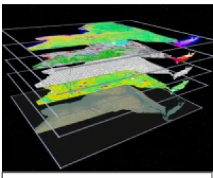
GIS - Linking Maps and Data
Although GIS is often thought of as computerized mapping, it is much more. The picture above shows digital photography with parcel boundary data outlined on top of it. The parcel data (depicted to the right) can be accessed, using GIS, by simply selecting the parcel.
Why Is GIS Important?
GIS is no longer viewed as a complicated, expensive tool for geographers and
cartographers to plot out maps. It has tremendous potential to affect a wide variety of fields, from community planning and economic development to political district mapping and criminal investigations.
In recent years, the use of GIS has grown rapidly in both the public and private sectors. While traditionally relegated to remote portions of an organization, more recently, with the advent of new products, GIS are rapidly becoming integrated into basic business applications. In other words, managers are using GIS in their day-to-day activities. Interest in GIS outside of the technology community is growing rapidly. The legal
profession should also be aware of how influential this tool is, with its capacity to provide powerful visual depiction of data.
This image was provided by the Department of Transportation to the Attorney General’s Office for use in defense of a major wrongful death case pending in the New York State Court of Claims. The image combines an aerial photograph draped over a 3D model of the land surface to provide a highly realistic depiction of the accident location, which occurred near the junction of a highway (shown in red) and the town line (in yellow). The Hudson River is in the foreground in this scene looking southwest towards Storm King Mountain.
The State of New York has taken a proactive role in recognizing the potential of GIS and working to coordinate GIS development and implementation. The State has established a framework for GIS use and collaboration not only among State agencies, but also with federal and local governments, other states, not-for-profit organizations, academia, and the private sector.
As GIS technology develops further, there are many issues that will need to be addressed, including defining how GIS data will be used, who will regulate it, and who will pay for it. As GIS is used more frequently in federal, State and local government, the public sector legal community will need to become aware of the implications of GIS use as it deals with licensing issues, cost and ownership rights, privacy, and confidentiality concerns.
How is GIS used?
The combinations of uses are only limited by the kinds of questions that need to be answered and the kind of spatial data (data that can be referenced to a street address, a census block, a highway mile marker or geographic coordinate, to name but a few methods of defining a position on the earth) that is available to answer them.
Engineers, planners, and cartographers have traditionally used GIS programs to analyze transportation systems, real property data and utility lines. Purchasing a GIS system often meant spending thousands of dollars on high-end workstations and complex software as well as training to use them. However, in the last few years, the development of PC-based and Internet GIS programs has begun to offer powerful analytical and mapping tools that are easier to use and come close to matching the sophistication of high-end tools at a fraction of the price. Program managers are starting to use these tools to analyze data and create presentations that meet their needs. Program managers around the country are recognizing GIS as a valuable tool to provide efficient and easy ways to represent, understand and solve complex problems.
Graphic created by the Visualization Program, Center for Theory and Simulation in Science and Engineering at Cornell University.
One of the most useful features of a GIS is its ability to overlay on a map a wide variety of disparate information in order to see how these different datasets combine to answer questions and solve problems. A GIS can be used to attract new businesses by locating the most favorable sites across the State. It can show the distribution of children under age five, within the city limits, along with the location of day care providers for preschoolers. It can show the distribution of agency service centers in relationship to shifts in the population that they serve.
In the past, data had to be specifically modified for GIS applications. However, due to the emerging trend of storing data in large integrated computer systems (data warehouses), the major GIS vendors are focusing on developing GIS software that will access this data without time consuming modifications. This will allow users to perform spatial analysis of existing datasets previously maintained for applications totally unrelated to GIS, thereby maximizing the value of these resources. More importantly, it provides managers with the opportunity to analyze this information using GIS tools and display it in a much more understandable visual medium.
Examples of GIS Use
GIS is recognized for its ability to assist governments in economic development, tax assessment, infrastructure management, emergency management, delivery of health and human services, planning and zoning, environmental management, transportation studies and crime analysis. The private sector is using GIS for such areas as market analysis, transportation routing, and insurance analysis.
In this past year, New York State’s use of GIS for health studies and emergency management has received a great deal of attention. For the first time, the Department of Health provided GIS data on cancer cases on its website. Later in the year, DOH used GIS to respond to the outbreak of encephalitis in the New York City metropolitan region.
There are almost limitless applications for GIS. Some examples are:
Economic Development. GIS offers enormous potential to support economic development. These systems can analyze locations for business expansion opportunities and can support the development and evaluation of public policies to guide expansion. A GIS can identify sites, locate
customers and suppliers, and help minimize transportation and shipping costs. It can also identify workforce characteristics, educational resources, and other quality of life elements that are important to business developers. Some communities use GIS to highlight assets and attract businesses to pre-selected sites in the community using the Internet.
Environment and Natural Resources Management. Geographic information analysis allows planners and policy makers to understand the environmental effects of their policy choices. Since environmental concerns do not stop at the county line, the information needed to assess them must be shared among different jurisdictions and agencies. GIS is used in New York to support such environmental management activities as managing forests, watersheds, wildlife habitats and wetlands, as well as monitoring various sources of pollution.
Education. Schools can use GIS for such things as forecasting
enrollments, optimizing bus routing and other planning needs. The box on State income tax forms that asks for a school district code is used by a GIS to help ensure that State school aid goes to the appropriate school district.
Infrastructure Management. The State's infrastructure--highways,
During 1999, GIS was used in Hurricane Floyd to locate facilities affected by power outages and flooding as well as to locate emergency generators with the closest proximity to those facilities. This capability was enhanced in preparation for potential Y2K issues.
railways, waterways, water and sewer systems, and electric, gas, telephone, and telecommunications systems--is the foundation of the State's economic development potential. The planning, design, construction, operation and maintenance of this infrastructure can be managed effectively through the use of GIS applications. For example, GIS is used in some communities to analyze the relationship between major employers, low income housing, and day care services to insure that mass transit is routed properly to service these citizens. GIS is also
utilized to analyze flood zones to determine which structures are within the 100 year flood plain and which are not. This type of information could result in a reduction of citizens’ bills for costly flood insurance.
Comprehensive Planning and Zoning. Comprehensive planning and zoning are used to determine the appropriate types, intensities and locations of future developments for a community. Economic development can be balanced in this process with environmental
protection, by developing strategies for the wise use and conservation of natural resources. GIS is an important tool for community planning by using inventory and analytical data of a community to simulate different program and policy scenarios in order to achieve community goals.
Real Property Records Management. Property information is the basis for maintaining, protecting and taxing property, and for planning, zoning, new infrastructure development, and the distribution of many municipal services. GIS can make property data readily accessible for economic development; allow property data to be the information base for many other uses; and can allow access to property data for such interested parties as banks, insurance agencies, real estate brokers and investors, title companies, and multiple listing services. GIS is used in some
communities to provide assessors with the tools to respond to inquires quickly over the telephone, allowing assessors to save time and provide better service to citizens.
Public Health and Safety. GIS applications for public health include epidemiology, facilities siting, and health needs assessments. Public safety applications include police and fire protection and disaster mitigation. GIS also is used in some communities to review crime incidents to determine more effective routing of police patrols or
relationships between the residences of past offenders and similar types of crimes. Communities are also using GIS to determine sites of recurring personal injuries and potential solutions to those problematic areas. In addition, GIS, in conjunction with E911 systems, can help determine the most effective routing to respond to emergency services.
Barriers to GIS Use
Despite the tremendous potential for this exciting new technology, there have historically been significant barriers to its widespread use. These barriers included the lack of user-friendly software, the high cost of the software (~$10,000), and availability of the data. Nevertheless, in the last few years we have witnessed a number of developments that have positioned GIS to become a fast growing technology:
The increase in computing power has resulted in software moving to a desktop application and no longer requiring expensive work stations to run on.
Software designers have developed new applications geared for managers not just for high-end users.
The New York State Temporary Geographic Information Systems Council was formed pursuant to Chapter 564 of the Laws of 1994. Its purpose was to “examine various technical and public policy issues relating to GIS and geographic information systems and analysis; to identify the structure, functions and powers of a state-level geographic information systems coordinating body; and to examine the role a state-level body could play in assisting in the development and implementation of local government geographic information systems.”
Under the statute, the Temporary Council was required to issue a report to the Governor and the Legislature that examined these issues and provided recommendations. That report was issued by the Council in March 1996. The Council’s report cited a project undertaken by the Center for Technology in Government (CTG) to investigate the benefits and barriers to developing cooperative GIS efforts. CTG’s report, "Sharing the Costs, Sharing the Benefits: The NYS GIS Cooperative Project" identified seven management and policy factors which hinder the sharing of spatial data:
• Lack of awareness of existing data sets;
• Lack of or inadequate metadata (information about data);
• Lack of uniform policies on access, cost recovery, revenue generation, and pricing;
• Lack of uniform policies regarding data ownership, maintenance, and liability;
• Lack of incentives for sharing;
• Absence of tools and guidelines for sharing; and
• Absence of state-level leadership.
The New York State Office for Technology (OFT), then functioning as the Governor’s Task Force on Information Resource Management, was assigned the task of
implementing the recommendations provided in the report. OFT’s approach to problem solving was predicated on a philosophy of collaboration, not control. It was committed to fast-paced, but purposeful change and believed that program needs drive technology, and not the reverse. (For more information about OFT, visit its website at
http://www.irm.state.ny.us.) Because up to 80 percent of the cost of a GIS system is associated with the development and maintenance of data, OFT concentrated on the sharing and redistribution of existing GIS data as a means to have the most cost-effective impact on statewide GIS implementation.
Private State Local COORDINATING BODY Legal Data Coordination &
Standards Education Finance
Clearinghouse & Communications
Advisory Groups
Work Groups
GIS Coordination Program
GIS Coordination Program
NYS Office for
NYS Office for
Technology
Technology
Digital Orthos
GIS Clearinghouse
GIS Data Sharing Cooperative
OFT began the process of coordinating a statewide GIS effort by meeting with representatives from local government, State agencies and the private sector. These groups made recommendations on a GIS Coordination Program that were incorporated into Technology Policy 96-18 (http://www.irm.state.ny.us/policy/tp_9618.htm). This policy not only established the statewide GIS Coordination Program, but also directed the development of a State policy for the easy transfer of digital GIS data at minimum or no cost.
The GIS Coordination Program is composed of various work groups of volunteer representatives from federal, State, and local governments, as well as the private sector, and started meeting in November 1996. By the first quarter of 1997, the Coordinating Body, which oversees the workgroups, had established the State’s first GIS
Clearinghouse (http://www.nysl.nysed.gov/gis), and developed a concept for data sharing unique in the country. By the summer of 1997, the Clearinghouse had been totally redesigned and expanded. A new technology policy, Technology Policy 97-7,
(http://www.irm.state.ny.us/policy/tp_976.htm) required State agencies to begin sharing GIS data between themselves and with local governments through a framework known as the NYS GIS Data Sharing Cooperative.
Building Bridges of
Communication
NYS GIS Data Sharing Framework
NYS GIS Data Sharing Framework
Local Gov. State Agency State Agency Local Gov. Local Gov. Local Gov. Local Gov. Local Gov. GIS GIS Clearinghouse Clearinghouse & Cooperative & CooperativeDevelopment of the Cooperative
In the first few months of the NYS GIS Coordination Program, both the Data
Coordination and the Legal Work Groups examined data sharing issues to arrive at a methodology acceptable to the majority of the parties involved. At that time, some State agencies used specific licensing agreements to regulate GIS data and its distribution while others distributed it upon request. Those who used licenses wanted to continue that practice, while those without licenses saw little need for it. In addition, local
governments with datasets were extremely reluctant to approach this issue without the protection that licensing offered them. At the time, the New York State Department of Transportation (DOT) had the most standard license. Nevertheless, licenses took several months to negotiate with agencies wishing to share data.
As depicted below, State agencies had to negotiate licenses between themselves and local government, therefore having to sign multiple agreements. Not only was that model cumbersome to operate within, it also was extremely time-consuming as each agency had its own nuances in each agreement.
In 1998, the NYS GIS Clearinghouse, combined with the Data Sharing Cooperative, was awarded the Exemplary Systems in Government Award in the National Spatial Data Infrastructure-Data
Partnerships category by the Urban & Regional Information Systems Association (URISA).
Typical GIS Licensing
Local Government DEC DOH ORPS DOS DOT Other AgenciesEnter the Cooperative Concept
After a number of very constructive meetings, a work group composed of the major State and local government GIS data holders developed a framework through which they all could agree to share data. This framework provided rules for open GIS data sharing within an entity known as the NYS GIS Data Sharing Cooperative (Cooperative), but allowed each member the ability to distribute its GIS data outside the Cooperative in a manner in which it saw fit. Joining the Cooperative was made easy by the use of one standard Agreement.
The rules of the Cooperative are as follows:
− The Cooperative is open to all levels of government and not-for-profit corporations;
− There are no fees to join the Cooperative;
− Ownership of GIS data is not necessary to belong;
− Members can borrow GIS data from any member for no more than the cost of distribution;
− The owner of the data is free to distribute its data outside the Cooperative;
− Members sign one standard data sharing agreement to join;
− Unless required by law, members cannot redistribute another member's data without the owner's permission;
− Members borrowing data are required to forward a copy of any improvements which they make to borrowed data back to the owner; and
− If a member is not satisfied with the Cooperative, the member simply returns the borrowed data and terminates the Agreement unilaterally.
With those simple rules, the Coordinating Body was able to obtain approval of the major State data holders as well as those at the local government level. The advantages of the
− Establishes a mechanism for GIS data sharing at all levels of government and eliminates the need for additional data sharing arrangements to be made;
− Provides easy access to and borrowing of GIS data;
− Avoids duplication of data development;
− Improves existing datasets; and,
− Saves money, reduces project time, and saves limited staff resources for local governments.
Success in the Cooperative
In establishing the Cooperative, membership began with State agencies utilizing a standard Agreement.
In March 1998, a second version of the Agreement was released for local governments and not-for-profits. (A sample of the local government Agreement is available on the GIS Clearinghouse at: http://www.nysl.nysed.gov/gis/coop/locldata.htm.) Later, similar versions were created and used for federal agencies and other states wishing to join. Growth in the Cooperative has been steady and currently, there are over 215 members. Members include:
– 80 State Agencies (includes 12 SUNY Campuses) – 82 Local Governments (includes 25 counties) – 7 Federal Agencies
– 2 States (VT & NJ)
– 48 Not-for-profits (includes 3 colleges)
Growth In Cooperative Membership
0 50 100 150 200 250 Oc t-97 Dec-9 7 Fe b-98 Apr -98 Ju n-98 Aug -98 Oc t-98 D ec-98 Fe b-99 Ap r-99 Jun-9 9 Au g-99 Oct -99 Dec-9 9 N u m b er o f M e m b ers
More important than the number of members is the ability of this simple framework and the GIS Clearinghouse to serve as a mechanism for easy data exchange. Currently, there are over 900 datasets available to members. Of those, more than 500 are available on-line seven days a week, twenty-four hours a day to anyone across the State.
Through the first eight months of operation in 1998, 8,500 datasets (valued at over $2,000,000) were exchanged through the Cooperative, or more than 10 times the amount that occurred in previous years. Through the first six months in 1999, more than 40,000 datasets (valued at over $3,500,000) were accessed from the GIS Clearinghouse over the Internet.
Increases In Data Sharing
0 5000 10000 15000 20000 25000 30000 35000 40000 45000 Dec-9 6 Mar -97 Ju n-97 Se p-97 Dec-9 7 M ar-98 Ju n-98 Se p-98 De c-98 Ma r-99 Ju n-99 Data Downloads Conclusion
As we move forward, the use of technology to provide solutions for government and improve business processes will increase significantly. GIS will become even more integrated into the public and private sectors as a means to improve services and save money. GIS has the potential for a wide impact across public and private sectors. There are many different parties that have a stake in GIS, and any guidelines or rules
established should address the needs of all involved. By working collaboratively, the technology and legal communities can succeed in making GIS a powerful tool.
James G. Natoli, Director of State Operations and Chair of NYS Office for Technology The author recognizes the assistance of:
BIBLIOGRAPHY
Center for Technology in Government, Sharing the Costs, Sharing the Benefits: The NYS GIS Cooperative Project, 1995
New York State Office for Technology GIS Clearinghouse, Executive Briefing, 1996 New York State Office for Technology, Technology Policy 96-18, Geographic Information Systems, 1996
New York State Office for Technology, Technology Policy 97-6, GIS Data Sharing, 1997 New York State Office for Technology Web Site: http://www.oft.state.ny.us
New York State Temporary Geographic Information Systems Council, Geographic Information Systems: Key to Competitiveness, 1996
New York State Office for Technology, NYS Lowers the Barriers to GIS, 1999
Visuals:
Cornell University, Center for Theory and Simulation in Science and Engineering NYS Department of Health
NYS Department of State
NYS Department of Transportation
James G. Natoli Director of State Operations
James G. Natoli is Director of State Operations. He was appointed Director of State Operations on January 1, 1995. As Director of State Operations, Mr. Natoli is responsible for the day-to-day direction of all State Departments and Agencies. Mr. Natoli serves as Chairman of the Governor’s Office for Technology.