Analysis of Bogota's
Bus
Rapid
Transit
System
and
its
Impact
on
Land
Development
Recent experiences in Latin
American
cities supporting world-classpublic transportation systemshaveresultedin the creation oflivablespaces with asignificantpotentialtospur landdevelopment. In cities like Bogota, Colombia,
and
Curitiba. Brazil, bus rapidtransit (BRT) has re-emergedas acost-effective transportation alternativefor satisfying
growing
demands
forurban
mobility.Bogota's
BRT
system has allowedfor a 32percent reduction inaverage traveltimesand
significantreduction in accident
and
air pollution levels along thebusway
corridors.Although
previousresearch suggests that the impacts
of
access toBRT
facilities on the nearby landvalueand
usehave been minor,
new
BRT
systems like the one in Bogota feature intensive infrastructurefacilitiesand
their effects in termsof
accessibilityand
mobility have been impressive. Thispaper
providesfirst-hand empirical evidence
on
the evaluationof
how
theBRT
system is related toland
development outcomes such as land values. FutureBRT
extensions will havea
large potential toinfluence future land development
and
induce desirable urban formsand
landusesaround
stationsand busway
corridors.Felipe
Taiga
and
Daniel A.Rodriguez
Introduction
Urbantransportationinfrastructure,inaddition
to serving its explicit goal ofproviding mobility,
historicallyhas served as
means
ofattracting andstimulating urban development.
By
effectivelyaltering
where
people live, work, andhow
theytravel, transportation systems
have
played asignificant roleinreshapingthe locationofactivities,
patterns
of
interaction, andgrowth
of cities.Mimicking
the experience ofcities in developedcountries, auto-centered transportation policies
prevailed in
most
20th-century cities in thedeveloping world. However, recent experiences
inurbanareasthatsupportworld-class publictransit
systems
suggest that rather than relyingon
automobile policies that reinforce patterns ofseclusion and isolation, policiessupporting
mass
transportationsystemsandfavoringnon-motorized
transportation alternatives have resulted in the
creation of livable spaces
and
the collectiveappropriation of these systems as images and
symbols ofthe public.
Althoughinitiallydecriedbymultilateral lenders,
this quietrevolution is
now
heralded by plannersand
elected officials as an agentof urban
redevelopment andsustainability.One
elementofthisrevolution istheprovisionofhigh qualitybus
transit service.
With
several successful casesFelipe Targa.
a
nativeof
Bogota. Columbia,receiveda
Master of
RegionalPlanning from
the University
of
North Carolina at Chapel Hillin 2003. This article is
based on
his mastersproject, which received the top
award
from thefrom
theDepartment
of
Cityand
Regional
Planning.
He
is currentlypursuinga
doctorateat the University
of Maryland
- College Park.worldwide,bus transit servicehas rc-cmcrged as a cost-effective transportation alternative for
satisfyinggrowingdemandsforurbanmobilitywhile hopefullystimulating landdevelopmentandlivable
spaces. This
new
concept for delivering busservice,
known
asBus
Rapid Transit systems(BRTs), is revolutionizing bus transit provision
around theworld, particularlyin Latin
American
cities.
BRTs
liketheones inCuritiba, Brazil,andBogota,
Colombia,
aresystems
with lanesdesignated for exclusive use by large-capacity
buses,andspecializedbusstationswith pre-board
ticketingand fastboarding. These characteristics
have drastically improved the level ofservice of
bus-basedtransitsystemsincludingaveragespeeds,
reliability,andcapacity.
However,despite theresurgenceofbustransit
services andthe success ofseveral
BRTs
aroundtheworld,thereis limitedresearchexaminingthe
relationshipbetween
BRT
and landdevelopment.The
paucity exists despite the fact that a carefulexamination of
BRT
impacts is critical for thetransportation
planning
process. Potentialmisperceptions of these impacts can lead to
significantfacilityredesign,construction delays,or
compensationtoaffectedparties,allofwhich
may
amount
to millions ofdollars. Furthermore, the successofinnovativeinfrastructurefinancingtools,such as value-capture, hinges on understanding
whetherornot positive infrastructureimpacts are
capitalizedintolandvalues.
This
paper
presents anexamination
ofBogota's
BRT
systemand its developmentas partof an integrated
urban
mobilityand
land development strategy. Additionally, the paperinvestigates the extenttowhichaccessibilitytothe
BRT
systemiscapitalizedintoresidentialpropertyrents as ameasure ofland values. Results from
hedonic pricemodelssuggest apositiveelasticity
of
local accessibility toBRT
stations aftercontrollingforproximity-relatedeffects tothe
BRT
right-of-way, structural,
and
neighborhood
attributes. This empirical evidence has a widerangeofpractical applications, fromdetermining the usefulness of innovative land-based tax instruments that hinge on the capitalization of
positive effects oftransportation investments, to
informing policy-makers aboutthelanddevelopment
consequences of transportation infrastructure
alternatives.
Bogota's
Urban
Mobility StrategyBogota,
the capitalof
Colombia,
hasapproximately 6.4 million inhabitants occupying
28,153 hectares(69,566 acres) ofurbanized area
(DAPD,
2000). Thismakes
Bogota one of themostdensecitiesintheworld,with approximately
230people perhectare. Despitea 1999percapita
GDP
ofUS
S2.300, 15 percent higher than thenational average, Bogota'sautomobile ownership
rate (130 cars per 1,000 inhabitants) is
low
comparedtocitiesinSouth
America
ofsimilarsize.Notwithstandingthislowmotorizationrate,thecity
is greatly affected by severe mobility problems,
partially due to the high population density.
By
1999, the average speed during thepeak houronthemainroadsdeclinedto lessthan 12kilometers
perhour(7.45mph).
With approximately 70 percent ofmotorized
tripstakenby busandothertransit
modes
such asparatransit, Bogota's quasi-deregulated and
free-enterprise transit system had one ofthe largest
percapitapublic transportationfleets intheworld
by 1996 (JICA, 1996).
The
excess ofvehiclecapacityandthelackofregulation resultedinlow transit vehicle occupation levels, inferior to the
minimum
requiredtomake
the service profitableand
efficient.The
transitsystem
was
alsocomplemented
byillegalbus operationsandintcr-munieipal
services that originate in areassurroundingthemetropolitanregion.
Although
many
studies diagnosing Bogota's mobilityproblemswere
conductedduringthelastdecade , a long-term plan to achieve a desirable
urban form and to promote its co-existence with an efficient and equitable transportation system
was
offtheagenda oflocaladministrations. Thischangedduringthelast
two
administrationsofthecity(1998-2001and2001-2004),
when
a sustainablestrategy forthe transportation system ofthe city
was
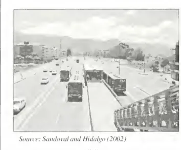
developed and implemented. In addition toFigure 1. TransMilenio
BRT
Caracas Corridortransportation options,thisstrategy,called"mobility
strategy,"
was
designed toachieve largersocietalobjectives such as
enhancing
public spaces,improvingsocialintegration,anddevelopingasense
ofownership andpridearoundredeveloped urban form.
A
cornerstoneoftheadministration'smobilitystrategy
was
theimplementationofahigh levelofservice,
BRT
system.This requiredtherevampingofa priorinitiativeimplemented between 1988and
1992,
which
provided exclusive lanes for busoperations.
The
16kms
(9.94mi) oflanestraversedthecity's
CBD
and connectedthesouthand northparts oftown.
More
than anetwork ofbus lanes,the Troncal Caracas acted as a high capacity
collector fed by routes needing to cross the city
rapidly(Ardilaand Rodriguez. 2000). Passenger
flows exceeded 36,000 passengers per houron a
givendirectionduringthepeakperiod (Ardilaand Rodriguez, 2000), but the
system
lacked anoperations
management
plan, allowing free entrytooperatorsmeetingspecificbussizerequirements
(Rodriguez andArdila,2002).
The
infrastructureitself
and
the bus stopswere
not adequatelymaintained,trafficlightswerenotsynchronizedand
gridlock
was
common
in several streets crossingthe
busway
(Ardilaand Rodriguez,
2000).Nevertheless, average bus speeds in 1999 were
24 kilometers per hour (14.9 mph), significantly higher thanthe citywide average.
Concerned
with anoversupply
of
the transitsenice,poor environmental and
safety conditions,
and
decreasing vehicle speeds, the
Bogota
citygovernment
decided
toupgrade
mass
transportationbyembarking on
extensive
investments
tosupport a
BRT
system.The
uniqueness of Bogota's case
liesinthetransformationofits
old system into an integrated system.
The
Caracas corridor (Figure 1) revolutionized anundesirable mobility system
(e.g.,aestheticallydispleasing,
with high noise and diesel exhaust levels) into a
new
BRT
system with significantly lower traveltimes, lower noise and fewer
greenhouse
gasemission levels(Rodriguez andTarga,2003).
The
BRT
isnow
a sourceoflocal pride.Complementary Urban
PoliciesThe
BRT
system is part ofa comprehensivestrategythatincludesrestrainingtheuseofprivate
cars, improving air quality, providing urban and
natural spaces for individual recreation and fare,
andtheprovisionofpublicspaceandnon-motorized
transport facilities. At a glance, ancillary policy
measuresinclude:
•
A
partial ban on peak-hourauto use.Thislicenseplate-basedprivate vehicleban
applies to
40
percentofthevehicle fleetduringpeakhourson weekdays. Thereis
also an annual car-free weekday.
•
The
reclamationofpublicuse ofspaces previously appropriatedbyautomobiles (suchassidewalks)orneglectedbyformercityauthorities(suchasparksandplazas).
•
The
implementationofa350-km
bikewaynetwork,one ofthelargest intheworld.
Bogota's strategy
was
designed not only toISyHsW
UJUIB1
K
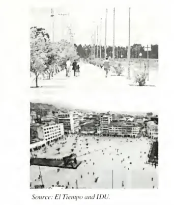
Source: £7TiempoandIDU.
Figure2. PublicSpaces
mobility,but alsotoachievelarger societalobjectives suchasenhancingpublic spaces,improvingsocial
integration, and developing a sense ownership
aroundredeveloped urban form. Inthe
words
ofits former mayor, Enrique Pefialosa,
who
left hisofficewith a record approval rating, the strategy
consisted ofcreating a "city environment
where
themajorityof peoplewillbeashappyas possible"
(Penalosa,2002).
He
visualizedthatpeoplewould
be happierinhealthier, safer,and
more
enjoyableplacesin
which
tolive,work, shop,andsocialize.One
ofthemeans
toachievethisobjectivewas
totransformthe transportationsystem,andtoreverse the trend towards an increasingly auto-oriented
transportation system (Penalosa, 2002). Perhaps
forthisreason.42.5percentofthecity'sinvestment
budget
(USS
1.8 billion for the three-year term)was
devoted to the ancillary policymeasures
describedabove(ArdilaandMenckhoff,2002).
One
ofthe most polemic policies, but at thesame
time one ofthe most emblematic ones ofthatadministration,
was
thereclamationofpublicuse ofspaces. Consistent with several planning
conceptshingingonurban designandcityformas
aninputtocomfortable, navigable,andparticipatory
urban public spaces (Whytc, 1988; Lynch, 1985;
Jacobs, 1961), the former Bogota
mayor
thoughtthat a quickerand
more
effectiveway
toachievequality oflife
was
to invest in public spaces.To
accomplishthis, the reclamation ofpublic use of
spaces includedthereconstructionof1,123 parks,
theimplementationofacar-free streetinthehistoric
CBD,
the construction of wide and continuouspedestrian sidewalks, including a1
7-km
pedestriangreenwaythroughpoorneighborhoods (Figure2,
top), and theredevelopment ofa 20-hectarepark
in a crime-ridden area (Figure 2, bottom) by demolishing
more
than 600 deteriorated houses (ArdilaandMenckhoff, 2002).Another key
project for the city is theimplementation ofone ofthe largest permanent
bicyclenetworkintheworld(Figure3),
a350-km
bikewaynetwork, intendedto capture 30percent
ofthetotaldailytrips inthecity. Thistravel
mode
shareissimilartotheoneinCopenhagen,wherea
300-km
network captures 34 percent ofthe total dailytrips. Consideringtheyear-round mildclimate,the flat valley where the city is located, and the
high urban density that
makes
most ofthe tripsbeing relatively short, the
demand
has currentlyrespondedwithincreasesontheproportionof non-motorizedtrips.
More
than providing alternativeandsustainable transportationoptionstomobility,
the assembling of the
bikeway network and
extensivewidesidewalks werealso conceived as
measures to improving pedestrian and bicycle
v
• J5i «££ I
Source: ElTiempo.
Source:SandovalamiHidalgo 12002
1
Figure4. TransMilenio
BRT
Stationsaccessibilityto
BRT
stationsand swaying peopleto leave theircars at home. Anecdotal evidence
suggests that approximately 10 percent ofthe
regular
BRT
system riders have switched fromprivate cars to TransMilenio, Bogota's mobility
strategy.
Bogota's
BRT
System
The
masstransitpolicyelement TransMilenio,isa
BRT
systemresultingfroma successfulpublic-private partnership, with the
government
fundingtheinfrastructureand overseeing long-term planning
functions, and private contractors bidding forthe
operationofahandful of
BRT
linesonacost-plusbasis (Rodriguez and Targa, 2003).
The
systemcomprises specialized infrastructure, including exclusivelanesforhigh-capacityarticulatedbuses
privatelyoperatedwith an off-boardfarecollection
system.
The
firstphaseofthesystemoperates with62stations.
470
articulated buses, and300
feederbuses.
The
vehiclesoperateinthe central lanesofurbanroads,andarclongitudinallysegregatedfrom generaltraffic. Stations are locatedinthemedian, approximately every 500 meters, with pedestrian
access
provided by
overpasses, tunnels, orsignalized intersections (Figure 4).
Walkways,
plazas,andsidewalksare alsoconstructedtosupply
pedestrian and bicycle access (Sandoval and
Hidalgo.2002).
With a flat fare of 1.000
Colombian
pesos(USS0.33), revenues
arc sufficient for theparticipatingprivatebuscompaniestobeprofitable.
Simultaneously, anew public authorityforplanning,
developingandcontrolling thesystem
was
created(TransMilenio
S.A.).TransMilenio began
operations in
December
2000.The
systemmoves
approximately 800,000dailytripsover 42,4
km
(26.2 miles)of busways,andcarriesmore
travelersthanentire mass transit systems in
many
other citiesaroundtheworld(I
EA,
2002). Figure5shows
thefirstphaseofthesystem(38 kilometers;23.6miles),
which
includes three corridors:Caracas, Callc 80(80thstreet),andAutopistaNorte(northhighway).
The
firstphaseofthesystemcostaroundUSS5
million perkilometer
(USS8.1
millionpermile),anditsneteconomicbenefitsaccountedfor
USS
1.2billion with a social rate of return of
60.9%
(CONPES,
2000). Similar to any transportationproject, themostsignificant impactofthe system
for its users has
been
travel time savings.Commercial
speeds increased from 12 kilometersperhour(7.5
mph
)to26.7kilometersperhour(16.6mph)
intheCallc 80and Caracas corridors. This©
TransMilenioPhase1
Busway
»
AUTOPISTA—-CALLE30
==CARACAS
WairR'.c Netv.rk
increase in bus speeds allowed for a 32 percent reduction in average trip times for users ofthe system (SandovalandHidalgo.2002). Additionally,
comparisons
between
before and after systemimplementationhave
shown
a significantreductioninaccidentandairpollutionlevels.
Between
1999 and2001, fatalitiesintheBRT
corridors resultingfromtrafficaccidentswerereducedby 89percent.
Similarly, injuriesandthe
number
ofcollisionswerereduced
by 75and
79 percent, respectively (SandovalandHidalgo,2002). Contaminationandemissionssuchassulfur dioxide, nitrogenoxides,
andparticulatematterwerereducedby43, 18,and
12 percent respectively (Sandoval and Hidalgo, 2002).
Extensionsareplanned overthenext 13years,
when
a 388-kilometer (241 miles)BRT
networkw
illbe completed. Thisnetwork systemwillcover80%
ofthe dailytransit trips inthecity (5 milliontrips perday), with a capital investment of
more
than
USS2.9
billion.The
infrastructurecomponent
ofthe project(USS1.9billion)isbeing financedby
localandnationalpublic funds.
The
citycovers 33 percent ofthe total cost via local fuel taxes, andthe national
government
is contributing theremaining67percent.
Althoughthere are several operationaland
cost-efficiencyqualitiesofthesystem, one ofthemost
important characteristics
was
its impressiveimplementation time. In lessthanthree years,the
firstphase ofthe
BRT
systemwas
planned, built,andinaugurated. Additionally, theimplementation
process did not suffer any significant change in
designorconstruction delays. Thisspeed has
come
atacost,though. Forexample, boththe beneficial
and deleterious impacts
upon
the neighborhoodsand property owners that have resulted from the
system
were
neglected in the evaluation and planning process.Anecdotal evidence
alsosuggests that there
was
littlecommunity
participationand poorqualitycontrol intheplanningprocess.
As
aresult,the firstphase ofthesystemwas
successfullyimplemented
withoutany
substantial compensation toaffectedparties.
Another
apparently neglected aspect ofBogota's
BRT
system is its potential tospur landdevelopment. Although theplanning ofthe
BRT
system took into account the location of major activitynodes,thereverse relationship,
how
BRT
can promoteadditional dense development along
its corridors
was
neglected. This omission issomewhat
surprising ifone considers that landdevelopmentinducedby
BRT
was
thecornerstoneofCuritiba'ssuccess. InBogota'scase,expediency
and practicality dominated the discourse around
the
BRT
station. Furthennore,asidefromCuritiba,thereisscantevidenceofthe relationshipbetween
BRT
anditslanddevelopment potential.From
theperspectiveofplanning,itisinterestingtoperforma posthoc evaluation of
how
theBRT
system is relatedto land development outcomes
such as land uses
and
values. Transportationplannersandpolicymakershavereliedonthenotion
that transportation
improvements
enhance
accessibility, and by doing so increase the valuesofthe nearby properties. However,the extent of
theseimpactsforBRTs, andthedifferentiationwith
proximity-related impacts, arc largely unsubstantiated by empirical evidence. It is this
lack of existing research, and the increasing
relevance of
BRT
systems as transportationmobility solutionsforseveralcitiesaroundtheworld,
thatmotivatedtheempiricalanalysisconductedin
thispaper.
An
evaluationofaccessibilityimpactsprovides first-hand empirical evidence ofthe importanceoftransportationpolicy alternativeson
land use. This information will strengthen the planning processforurbantransitsystemsandwill bevaluableforunderstandingthelocalconditions
forwhich innovative land-basedtax instruments,
suchasvalue-capture, will bemostuseful.
Valuation of Access to
TransMilenio
As
inseveralotherstudies,we
adoptahedonicprice
model
approach toempirically evaluatethecapitalization ofaccessibility effects of Bogota's
BRT
onresidential propertyrents asameasure ofland values. Based on the theory ofthe market
forheterogeneousgoods(Rosen, 1974), thehedonic
technique allow ustoestimatepricesofgoodsthat
arenotexplicitlyexchangedinobservablemarket
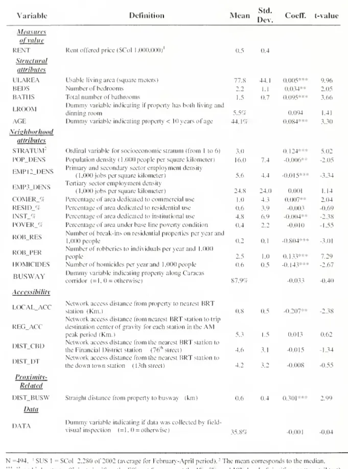
Variable Definition
Mean
Std.Dev. Coeff. t-value
Measures ofvalue I'l \l Structural attributes
ULAREA
BEDS
BATHS
LROOM
AGE
Seiahborliood attributesSTRATUM
: POPDENS
o
o
EMP12_DENS
too
EMP3_DENS
ccCOMER_%
RESID_% [NST_%POVFR
<7r -J 2: o:o
CD§
Q.ROB_RES
ROB_PER
HOMICIDES
BUSWAY
Accessibility|
O
CCLOCAL,
ACC
o
REG_ACC
DIST.CBD DIST.DT Proximity-Related I)1ST_BUSW DataRentoffered price($CoI1,000,000)' 0.5 0.4
IIsablelivingarea(squaremetersI
Numberofbedrooms
Totalnumberofbathrooms
Dummy
variable indicatingifproperty hasbothlivinganddinningroom
Dummy
variable indicatingproperly< lOyears of ageOrdinalvariable forsocioeconomicstratum(from 1 to6) 3.0
Populationdensity(1.000 people per square kilometer) 16.0 7.4
Primary andsecondary sectoremploymentdensity
(1,000jobs per square kilometer) 5.6 4.4
Tertiary sectoremploymentdensity
(1,000 jobs persquare kilometer)
Percentageofareadedicatedtocommercialuse Percentageofareadedicatedto residentialuse
Percentage ofareadedicatedtoinstitutionaluse Percentageofareaunder baselinepoverty condition
Numberof break-insonresidential propertiesperyearand
1.000people
Numberof robberiestoindividuals peryearand 1.000 people
Numberofhomicides peryearand 1.000 people
Dummy
variable indicating propertyalongCaracascorridor (=1.0 =otherwise)
77.8 44.1 0.005 9.96
2 2 1.1 0.034** 2.05
1.5 0.7 0.095*** 3.66
5.5ri 0.094 1.41
44.1% 0.084*** 3.30
0.124*** -0.006** -0.015*** 87.9% 0.8 0.5 -0.033 -0.207**
DATA
5.02 -2.05 -3.3424.S 24.0 0.00
1
1.14
1.0 4.3 0.007** 2.04
0.6 3.9 -0.003 -0.69 4.S 6.9 -0.004** -2.3S 0.4 2 i -0.010 -1.55
0.2 0.1 -0.804*** -3.01 2.5 1.0 0.133*** 7.29 0.6 0.5 -0.143*** -2.67
-0.40
-2.38
5.3 1.5 0.013 0.62
4.6 3.1 -0.015 -1.34
4.2 3.2 0.008 -0.55
Networkaccessdistancefrom propertytonearest
BRT
station (Km.)
Networkaccessdistancefromnearest
BRT
stationto tripdestinationcenterofgravity foreachstation inthe
AM
peakperiod (Km.
)
Networkaccessdistancefromthenearest
BRT
stationtothe FinancialDistrictstation (76lhstreet)
Networkaccessdistancefromthenearest
BRT
stationtothedowntownstation (13thstreet)
Straightdistancefrompropertytobusway (km) 0.6 0.4 0.301*** 2.99
Dummy
variable indicatingifdatawascollectedbyfield-visual inspection (=1. =otherwise) 35.8% -0.001 -0.04
N
=494. 'SUS 1 =SCol 2.280of2002(averageforFebruary-April period).;
Themeancorrespondstothemedian.
"*. ",and'
denotecoefficient significantly differentfromzeroatthe l°o.
5V
and 10%levelofsignificance (two-tailtest)respectively. Interceptisequalto-1.820(t-value=-8.09).R:
isequal to0.74. SeeNotes,facing page.
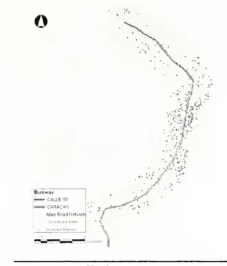
o
Busway
=5=5=CALLESO
ssCARACAS
MainRoadNetwork
i54-m But*«Surer RetKxnulPicpeitei
statisticsofthedata
employed
inthispaper.In order to specify and evaluate the hedonic
price function,ourempiricalexaminationrequires
an estimateofland values,as wellas information
on structural and neighborhoodcharacteristics of
residential properties.
As
aresult,we
undertookaprimarydata collectioneffort.
The
data collection processbeganwiththe selectionofa 1.5kilometer(0.93 mile) buffer areaaroundthe two
BRT
lines(Caracas and Calle 80 corridors). Information
regarding residential advertised rent prices and structural attributes
was
collectedforallpropertiesavailableforrentwithinthisbufferarea.
The
finaldatasetconsists on asample of
494
multi-familyresidential properties surveyed from February to
Aprilof
2002
(Figure6).Figure6. Areaof Study
systems.
The
basic empirical relationship to be evaluated under this approach is the equilibriumimplicit rent ofthe property as a function ofits
attributes:
r> ~ i ft
V
Structural , ft \r NeighborhoodP
i
=c +
p
sX
i+p
N
X
ij_
R
V
Accessibility , /?y
Proximitx , *+
P,\A
i
+
Pp
A
i+£
twhere Pi is the rental price ofthe ith residential
property. Xij isthejthattribute fortheithproperty,
,
p
s , Ph ,Pa an d Prare vectors with coefficientestimatesfor structural,neighborhood,accessibility,
andproximity-related effects orattributes (implicit
empirical marginal price for each attribute), c is
the intercept constantterm, and ei is the
random
errorterm fortheithproperty. Table 1 presents a
description of the variables and the
summary
o
™3
"-Accessibilityf
Figure 7. Accessibility'
&
ProximityTable 1.Notes:
a)32missing values (6.5%)from
ULAREA
werefilledbybest-subsetregression(imputed). Similarly, the2? missing values (4.7%)fromthedummyAGE
variablewereset tothemedian.Foreach ofthesetwovariablesdummyvariables are usedinthemodelstocapturethe effectoftheseimputedobservations.
b)Rentoffered priceandstructural attributeswerecollectedbetweenFebruaryandAprilof 2002.Socioeconomic
variablessuchaspopulationandemploymentdata arefrom 1998.while crimedata arefrom 2001.
c)Neighborhoodattributes,exceptStratumand Busway, wereweight-assignedfromTAZ-levelto250-meter
Local access distance to
BRT
stationswas
measured based on the shortest roadway-basedpath fromeach residentialproperty tothe nearest
BRT
station,ratherthanamere
Euclideandistance(Figure 7). In addition to accessibility to
BRT
stations. Euclidean distance from the residential
property to the
BRT
right-of-waywas
used as ameasure ofnuisanceproximity-relatedeffectssuch asnoise and air pollution (Figure 7). Structural
attributes include usable living area (in square
meters),
number
of bedrooms, totalnumber
ofbathrooms (including half baths), and
dummy
variablesforlivinganddining
room
area,andiftheproperty islessthan 10 yearsold.
Neighborhood
attributes include
socioeconomic
stratum,populationand
employment
density,percentageofurbanized area dedicated to retail, residential, or
office uses,andcrimedatasuchas homiciderates
androbberies.
Results from the semi-logarithmic hedonic
pricefunctional formusing
OLS
regressionsuggestthatthecurrentvaluationoflocalaccesstoBogota's
BRT
systemis capitalized intoaskingrent prices.Particularly, the parameter estimated suggests a
monthly
rental discount of1.87%
for everyadditional0.1
km
(328 feet)fromaBRT
station,allelse being equal. Evaluated at the
mean
rentalasking price (Table 1 ), this translates into an
elasticityof-0.16.
By
determining the capitalizationofpositiveBRT
effects (local access toBRT
stations), thelocalizedevidence fromthisstudyprovides,onthe
one hand, tools for exploring the usefulness of innovative land-based tax instruments. For example, a value capture tax that theoretically
should hinge on the capitalization of positive
benefits
on
land valuesfrom
infrastructureimprovements
is validatedfrom
the empiricalevidence
presentedon
this paper.Local
governments andlocal transitagenciescouldjustifythenatureandmagnitude ofcharges derivedfrom
value capture,
known
as valorizacion , toparcelsnearby transportation
improvements
ornew
constructionfacilities.
On
theotherhand,thecapitalizationofaccessonland rents alsosuggeststhatthereisa potential
forfuture landdevelopment. SimilartoCuritiba's
experience,
where complementing
land-use initiatives weretakenin orderto inducedesirable urban formsand landusesaroundBRT
stationsor along corridors. Bogota's futureBRT
extensionshave a large potential to influence future land
development and urban growth. For example, a
worldofunexplored proactive land use planning
foraworkabletransit-landusenexus,thathasbeen
absentfromtheplanningprocess,should bein the
agenda of Bogota's transit and urban planners. Local officials could take advantage ofthe land
market
(e.g., fostering fasterand
more
concentrated urban development) as a response
to the capitalization effects from access to
BRT
stations.
Finally,there arc threemainlimitationsofthis
studythatshouldbe underscored. First, theuseof
cross-sectional datalimitstheabsoluteattribution
ofthe
premium
found on asking rental prices tothe presence ofthe
BRT,
instead it is an actualmeasureor valuation ofaccess. Further research
(e.g.,usingtime-seriesdatafora beforeand after
study)
may
determineifthepremium
detectedcanbeattributedtothepresenceofthe
BRT.
Second,the use ofasking rental prices, instead ofactual
prices,
may
bias the results if there isany
systematic bias in the difference between asking
and
market
rental price associated withunobservable characteristics on the study.
And
third,furtherresearchshould focuson commercial
andofficelandvaluesinordertoevaluate the other
parts
of
theexpected
relationshipbetween
accessibilityandtheland market.
Conclusions
Rather thanrelyingonautomobilepoliciesthat
reinforce patternsofseclusionandisolation,recent
experiences in Latin
American
cities supportingworld-class public transportation systems have
resulted in the creation of livable spaces with a
significantpotentialtospurlanddevelopment and
future urban growth. In cities like Bogota and
Curitiba, bus transit
sen
ice has re-emerged as acost-effective transportation alternative for
example, Bogota's
BRT
has allowed for a 32pereent reduction inaveragetraveltimes forusers ofthesysteminadditiontosignificantreductionin
aecidentandairpollutionlevelsalongthe
busway
corridors. Inadditiontoservingitsexplicitgoalof
providingmobility,thisrevolutionforprovisionof
high quality bus transit service has
shown
itspotential for stimulating land development and
livable spaces. DespitecaseslikeCuritiba,
where
BRTs
haveplayedanintegralroleinthesuccessfularticulationofanintegratedlanduseandtransport
strategy,thereisscantevidenceofthe relationship
between
BRT
and its landdevelopmentpotential.Thispaper providesfirst-handempiricalevidence
onthe evaluationof
how
theBRT
systemisrelatedtolanddevelopment outcomessuchaslandvalues.
Previous research suggests that the impacts
ofaccessto
BRT
facilitiesonthenearby land valueand use have been minor. However,
new
BRT
systems like the one in Bogota feature intensiveinfrastructure facilities and their effects in terms
ofaccessibilityandmobilityhave beenimpressive.
Based on this previous premise, this paper finds evidencethatthe current valueofaccessibilityto Bogota's
BRT
are capitalized into residential propertyrentalprices. Giventheempiricalhousingrent-landvaluerelationship,these results suggest
that property rental prices are a theoretical
representation of the land value for
housing
services.
To
the degree that the results fromthis study can begeneralized,thisevidence hasawiderangeofpractical applications, from determining the
usefulnessofinnovativeland-basedtaxinstruments
that hinge on the capitalization ofpositive
BRT
effects, toinformingpolicymakersaboutthe land
development consequences
of transportationinfrastructure alternatives. Recent studies about
incentive taxation have
shown
that value capturerepresents an alternative approach to capital cost
recovery that has not been fully explored and examined inthe tax policy context. Bart (2001
)
noted
how
only afew
studies, if any,have
recognizedthe relationshipbetweentransportation,
land use,andtaxation. However,there is
enough
evidence fromstudiesthat
show
themeritsof value-capture as an instrument ofpublic infrastructurefinance (Allen, 1987; Ccrvero, 1994;Johnson and
Hoel, 1985).
In addition to being an efficient
method
forpublic funding of transit infrastructure, value-capture also encourages faster and denser urban
development in areas in close proximity to
BRT
lines,
assuming
that density caps are not aconstrainingfactor. Giventhehigherrentsonland
valuesinlocationswith
good
access,itisexpectedthatlandownerswill try torecovertheirinvestments
rather than hold
them
for speculative gain (e.g.,BRT
fosters fasterand
more
concentrated
development). This is always a desired
outcome
for policy
makers
regarding transit-orienteddevelopments because it has implications forthe
viabilityoftransitoperation. However,to ensure
thisurbandevelopment
outcome
itisnecessarytocomplement
thistaxationpolicywithmechanisms
such as higher density caps and mixed-use land-use zoning.
The
extenttowhichpositiveeffectsof Bogota'sBRT
system are capitalized into property valuesprovides apromising approachforpublicinstitutions
to fund
BRT
extensionsand
general transitinfrastructure. With extensions planned over the
next 13 years, issues relatedtoboth itsbeneficial
and deleterious impacts
may
become
ofgrowingconcern to boththe affected public andto transit
planners.
When
completed. 85percentofBogota'spopulation will be located in a 500-meterarea of
influenceofthe
BRT
system,where
positive andnegative impactsareexpectedtoinfluence property valuesand future landdevelopment.
Acknowledgments
We
are gratefultoAngelicaCastroandDarioHidalgofrom TransMilenioS.A.andVivianBarrios
for their invaluable data collection assistance.
Financial support
was
provided in part by theReferences
Lynch,k„
1985GoodCitv Form.MIT
Press.Allen, B., 1987 "ValueCapture inTransit,"Journal of
theTransportationResearch Forum,Vol.28: pp.50-57.
Ardila,A.and Rodriguez.DA.,2000."Ilow ChaosBuilds Ridership:Operationsofan Exclusive BusvvayCam.ing Over 35,000 Passengers Per Hour per Direction,"
TransportationResearchRecord,No. 1726.
ArdilaA.,MenckhofTG.,2002"TransportationPolicies
in Bogota: Building a Transportation System for the
People".Paper presentedattheTransportationResearch Board 81thAnnual Meeting. Washington, D.C. Paper
01041,
CDROM.
Pefialosa E., 2002 "Urban Transport and Urban
Development:
A
DifferentModel". Speech conductedintheCenterforLatinAmericanStudies,Universityof
California,Berkeley.
Rosen,U.S.. 1974"Iledonic PricesandImplicitMarkets:
Product Differentiation inPure Competition,"Journal
oj PoliticalEconomy,Vol. 82, pp. 34-55.
Sandoval, E. and Hidalgo,D., 2002 "TransMilenio:
A
high capacity - low cost bus rapid transit system
developedforBogota, Colombia."Unpublishedmimeo,
TransMilenioS.A., Bosiota,Colombia.
Batt, W.II., 2001 "Value Capture as a Policy Tool in
Transportation Economics:
An
exploration in publicfinance in the tradition ofHenry George," American
JournalofEconomicsandSociology;Vol. 60,No. 1,pp.
195-228.
Cervero.R., 1994"RailTransitandJointDevelopment:
LandMarketImpactsinWashington,
DC
andAtlanta,"Journal oftheAmerican PlanningAssociation,Vol. 60,
No. 1,pp.83-94.
CONPES
(Consejo Nacional de PoliticaEconomicay Social), 2000"Sistema de Servicio Publico Llrbano deTransporte
Masivo
de Pasajeros de Bogota-Seguimiento-."DepartamentoNacional de Planeacion.
DocumentoNo.3093.
Smolka,M.and Amborski,D.,2000"Value Capturefor
Urban Development:
An
Inter-AmericanComparison." Lincoln Institute of Land Policy, Working Paper. Cambridge,MA.
Rodriguez, D. and Ardila, A., 2002 "An Empirical
ExplorationofBusTravelTimesand DwellTimesina
Highly Competitive Exclusive Busvvay," Journal of
PublicTransportation, Vol. 5,No. 1,pp.39-60.
Rodriguez. D. and Targa, F.. 2003 "The value of
accessibility to Bogota's bus rapid transit system,"
TransportReviews,(forthcoming).
Whyte,W., 1988City: RediscoveringtheCenter,
New
York: Doubledav.DAPD
- AlcaldiaMayor
de Bogota, 2000, Plan deOrdenamiento Territorial de Santa fe de Bogota
-DocumentoTecnico de Soporte. DecretoNo.l110 del
28 deDie.de2000. Alcaldia
Mayor
de Bogota. Bogota, Colombia.IEA(InternationalEnergy Agency),2002 "Bus Systems
for the Future; Achieving Sustainable Transport
Worldwide,"IEAPublications,France.
Jacobs,J., 1961 TheDeath andLifeofGreatAmerican
Cities,
Random
1louse.New
York.JICA-ChodaiCo. Ltd.. 1996 EstudiodelPlan Maestro
del Transporte Urbano de Santa Fe de Bogota en la
Republicade Colombia.IDU.Bogota.
Johnson,G,and1loel,L.A., 1985"AnInventoryof Value Capture Techniques forTransportation," University of