Learning from the Experts: Enabling and Studying DIY
Development of Location-based Visitor Experiences
Ben Bedwell, Peter Slack, Chris Greenhalgh
The University of Nottingham
Nottingham, United Kingdom
{
benjamin.bedwell, peter.slack, chris.greenhalgh
}@nottingham.ac.uk
ABSTRACT
In this paper we show how – with the aid of enabling tech-nology – creative Location Based Experiences can be devel-oped for visitors by non-technical professionals from the cul-tural heritage sector. We look at how these “Place Experts” approach and adopt web technologies to create and publish experiences including the roles they take on, the processes they adopt, and the way they appropriate the technology. We describe our short and long-term research engagements with the cultural heritage sector over the last three years and intro-duce Wander Anywhere, the website developed to enable this research. We find that place experts typically follow a four stage process in their engagement with location-based expe-riences, moving from comprehension to translation, develop-ment and finally approval. We suggest implications for the processes and technologies that might be employed by others seeking to support a similar type of engagement.
Author Keywords
Location; location based experience; mobile; cultural heritage; authoring; user studies
ACM Classification Keywords
H.5.m. Information Interfaces and Presentation (e.g. HCI): Miscellaneous
INTRODUCTION
Over the past three years we have engaged in collaborative re-search on location-based technologies with partner organisa-tions and professionals from the cultural heritage sector. We enabled this research by developing a website that allowed our partners to create, test and deploy Location Based Expe-riences (LBEs) for visitors. Our aim was to learn from the way they approached and adopted this technology.
Since Cyberguide [27] almost two decades ago, the HCI com-munity has developed a significant body of work exploring the opportunities for LBEs in tourism, heritage and culture, or more generally in relation tovisiting, e.g. [12, 1, 4, 19]. Our
Paste the appropriate copyright statement here. ACM now supports three different copyright statements:
•ACM copyright: ACM holds the copyright on the work. This is the historical ap-proach.
•License: The author(s) retain copyright, but ACM receives an exclusive publication license.
•Open Access: The author(s) wish to pay for the work to be open access. The addi-tional fee must be paid to ACM.
This text field is large enough to hold the appropriate release statement assuming it is single spaced.
Every submission will be assigned their own unique DOI string to be included here.
own previous research in this area – and that of our close col-leagues – has involved playing a pivotal technical role in de-ployments of location-specific experiences. Acting in this ca-pacity has revealed technical implications for location-based technologies, and enabled us to explore new applications of LBEs. However, we recognise technical challenges that limit exploration of LBEs by communities such as the cultural her-itage sector.
Reflecting on the current state of mobile technologies partic-ularly the ubiquity of “smart” mobile devices, the emergence of HTML5 with benefits such as offline, and geolocation sup-port and the increasing accessibility of mobile wireless broad-band [29], there is now an opportunity for the research com-munity to createenabling technologies that allow the man-agers, experts and volunteers at tourist sites “place experts” to author web content and deliver it to the location-aware web-browsers in many of their visitors’ mobile devices. We in-troduce the culture and heritage sector in this paper and note that place experts often have experience of designing outdoor visitor activities, but have yet to adopt mobile technologies as a means of delivering visitor offerings, perceiving certain barriers to doing so.
To explore the potential for enabling technologies, we de-veloped a technical artefact – a website – that allows non-technical users to attempt “do-it-yourself” (DIY) authoring, deployment and iteration of LBEs. This was achieved by leveraging ubiquitous web software, resulting in interfaces that aremundaneand allowing users (both authors and vis-itors) to interact usingtheir owncomputers and mobiles. We position the website as a novel technical artefact for the cul-tural heritage community. In contrast to previous work that sought to validate support tools in the confines of research sessions, e.g. [17, 26, 15, 32], we have worked with the cul-tural heritage sector to support and study their use of Wander Anywhere “in the wild”. Specifically, we sought to support place experts in the different roles they take during the pro-cess of understanding, developing and releasing LBEs. Our relationship with partners has taken a variety of forms, rang-ing from prototyprang-ing workshops to full iterative development processes resulting in real-world public releases.
themes, from the collaborative activities with our partners. Taking a retrospective view of this long-term process of col-laborative research, we also present the typical four stage pro-cess that the place experts went through, along with the im-plications for processes and technologies that we believe can facilitate effective engagement by place experts with LBEs.
CONTEXT
The research described in this paper was triggered by our previous engagements as technical researchers with practic-ing artists and the cultural heritage sector. We have been involved in several streams of research exploring new roles for mobile technologies in location-specific performance, art and heritage offerings. We have worked closely with “place experts”, i.e. experts on the locations for which LBEs are designed, such as local historians [11, 34], local government authorities [20], local businesses [3] and local residents [35]. These efforts have resulted in a range of real-world deploy-ments of novel technological artefacts, including location-specific games (e.g.[6, 5, 20]) and guides (e.g. [35, 3, 11, 34]).
In each of these cases, researchers have arguably played as much the role of technical developer as researcher. Develop-ing a novel technology is a means to an end; in most cases the research aim was to explore the applicationsenabled bythe technology although in doing so, implications for the tech-nology are revealed. Enabling a novel experience involving remote and in situ users revealed the value of self-reported positioning over GPS in urban environments [6]. The expe-rience of touring such expeexpe-riences demonstrated how design-ers of LBEs might benefit from tools that revealed “seams” in wireless infrastructures, leveraging them as design fea-tures [5]. Co-designing visual markers with non-technical experts demonstrated the need to be able to explain – in non-technical terms – the computer vision rules at play [28]. Be-cause the underpinning technologies here are novel, a signif-icant amount of technical skill is required in bringing them together in a timely fashion to allow the research to happen. Indeed, toolkits such as EQUIP2 [21], DART [18], and Dey et al.’s Context Toolkit [16], have been built to make this pro-cess more rapid.
Reflecting on Cyberguide, we question whether we have moved on. On the one hand, we have explored a range of new applications of location-based technologies; on the other, the technologies are still bespoke, sophisticated and hardly ubiquitous, thus perpetuating the siloing of LBE expertise (as noted in [33]) to research institutes and software labs. In-stead, we believe that we can gain valuable new insights by sharing responsibility for more aspects of the development and deployment process with our partners. We have made small steps here before. In [3], we considered how technolo-gies can enable place experts to orchestrate LBEs; in [31] we see how place experts adapt and use tools developed by re-searchers to refine an LBE. However, by handing over the entire process – by enabling place experts to develop LBEs from concept to public release – new use cases and examples may also proliferate, providing a fruitful area for research. Hull et al. pose the analogy of the democratisation of web
publishing, whereby easy-to-use, freely available tools allow almost anyone to create web-sites, spurring on our collective understanding of what it is possible to produce [23]. Weise et al. argue that place experts (including local residents)should
be more involved in the development of LBEs and ubiquitous infrastructure that they are built on, as a means of maintaining control over their localities [39].
Enabling the Development of LBEs
Researchers have already sought to contribute technologies to encourage the development and evaluation of LBEs by non-technical experts. iCAP simplifies the conditional program-ming of context-based experiences (including LBEs) through a visual interface [15]. Mediascapes [23], StoryPlace.Me [7] and LoMAK [17] (as well as commercial systems such as 7scenes1) allow authors to visually geo-fence trigger loca-tions and link these to locative media. Topiary applies a visual story-board metaphor to the design of LBEs [26].
These tools have demonstrated variable success. Bentley et al. describe how older users were able to use the Serendipi-tous Family Stories authoring tool with ease to carry out sim-ple authoring tasks [8]. However, Hull et al. describe the difficulties experienced by authors in coming to terms with programming concepts that spilled over into the Mediascapes authoring tools [23], while Li et al.’s user study shows how the complexity of LBEs can be difficult for authors to model in their simple desktop GUI [26]. Hull et al. describe such systems as “programming in the small” [23], highlighting the emphasis these systems place on being at the desk during the authoring process. Researchers studying such systems often note mismatches between the intentions of the LBE authors and their experience in the real world [38, 14]. Place experts using LoMAK found it difficult to predict what mobile users might be able to see while walking [17], while the effect of GPS “errors” surprised authors using Mediascapes [23]. In general, the effects of the outdoors – including lighting and ambient noise – can make the mobile experience of media radically different from the desktop [2], and difficult to eval-uate using traditional techniques [10].
To address this, tools that allow place experts to author and
evaluate LBEs “in the wild” have also emerged. Urban
Tapestries provided locals with a mobile app to create con-tent “on location” and contribute this to a public collection of locative media [25]; this project highlighted the importance of being on location as a means of understanding how locative media might be interpreted in situ. The Tidy City project pro-vides both mobile and web-based authoring tools that allow an author to walk an environment to produce a rough draft of their LBE then refine the design at a desktop [40]. This notion of refinement is also adopted by CASTOR [32].
These examples show that it is possible to hand over the pro-cess of authoring an initial design of an LBE to non-technical users. By learning new easy-to-use tools, place experts are also able to experience how their design translates to the real world. However, these tools do not support place experts in progressing an LBE beyond the initial prototype stage. In
fact, we have seen little evidence of research that demon-strates how place experts can be actively included initerating,
deployingor in runninguser testsof their designs. The recent PLACE framework [9] considers LBE design as an involved iterative process, encouraging designers to move from con-cept development to evaluating their designs with real end-users, in real social configurations, with their own devices. This framework appears to be aimed at researchers, rather than place experts. We question whether place experts might take on responsibility for more roles in this longer term pro-cess of LBE development, thus allowing us to focus on learn-ing from their efforts “in the wild”.
The Cultural Heritage Sector as a User Community
The cultural heritage sector, i.e. organisations and individu-als who work to preserve monuments, natural environments, historical records, art and cultural practices, represents an ob-vious potential user community for technologies that support the creation of LBEs. Over the past three years, we have part-nered with a range of place experts from cultural heritage or-ganisations around the UK.
In late 2012 – at the start of this research – we convened a meeting of 14 heritage site managers from the UK. To judge the expectations of this community, we presented a range of the location-specific experiences developed by the research community. A representative response from a manager of an independent local heritage site suggests a gulf in expectation:
“these are inspiring – really fantastic – butwayout of our league! We’d settle for some gentle steps, you know, translat-ing the outdoor activities we currently offer to mobile phones and see how this opens new doors”.
We focused on understanding why the attendees were not taking the “gentle steps” towards exploring mobile location-based experiences. Out of the resulting discussion, the fol-lowing factors were suggested asthree key barriers: cost of outsourcing development, risk of paying for an unsuitable product, and lack of familiarity with the developer commu-nity. More generally, these barriers arise from a need to hand-over control for the development of mobile experiences to ex-ternal agents. The attendees were not used to doing this dur-ing the development of other sorts of visitor experience. This quote from the regional director of one of the UK’s largest conservation charities conveys the group’s consensus: “we happily leave our experts to invent really wonderful activities for our visitors, but with mobile we have to hand over ideas to the digitals (design agencies). We can’t just try and work it out for ourselves”.
RESEARCH METHODOLOGY
Shaped by the meeting in 2012, our research methodology involved the long term engagement of our user community – cultural heritage organisations and professionals – via the release ofWander Anywhere, a website that allows users to author, deploy and review the use of LBEs2. For our user
community, this was a novel technological artefact, and we refer to the concept oftechnology probesto explain our aims in developing it. A primary aim with technology probes is
2See http://wanderanywhere.com/
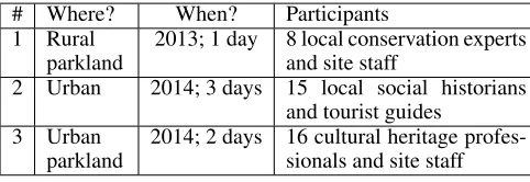
# Where? When? Participants
1 Rural
parkland
2013; 1 day 8 local conservation experts and site staff
2 Urban 2014; 3 days 15 local social historians
and tourist guides
3 Urban
parkland
[image:3.612.321.562.61.144.2]2014; 2 days 16 cultural heritage profes-sionals and site staff Table 1. Wander Anywhere make-and-do workshops
to get them out, into “the wild”, to allow patterns of use and disruptions to emerge: they are “not a prototype, but a tool to help determine which kinds of technologies would be inter-esting to design in the future” [24]. Technology probes are de-ployed into real situations with real users [37]. As a research tool, we expect probes to cause changes in the behaviour of the user community, but also for the user community to adapt and extend the tools to suit their needs.
At one end of a spectrum, probes might be a component of “breaching experiments” [13], provoking unexpected new practices in entirely new contexts of use. Our aims were less radical. In our case, long-term processes exist within the cul-tural heritage sector for developing and evaluating visitor ac-tivities; we deployed Wander Anywhere as tool to explore how these existing practices, the roles of experts, and the ex-pectations of mobile technologies might change. We do not see this as a breaching experiment; instead we have carried out bothshortand relativelylong-termresearch interventions, to observe the impact of the artifact on theexpectations of the communityand thedevelopment practices of the community
respectively. We describe these two styles of research engage-ment in more detail below.
Short engagements: “make-and-do” workshops
During our research we have conducted three “make-and-do” workshops, bringing together place experts from our target community for up to three days (depending on availability of the experts) of rapid LBE creation and iteration at an outdoor location with interesting heritage. We invite participants from a variety of organisations in our target community to attend (see Table 1). Attendees almost exclusively claim no skills in developing mobile experiences: two of the guides who at-tended workshop #2 had experimented with native apps to create walking tours, and one attendee to workshop #3 had experience of creating content for audio-guide apps.
# Where? When? What? End-users
1 Urban
parkland
2012; 3 months
Concept to
public tests
21 experts
2 Rural
parkland
2012-3; 1 year
Concept to 6-week public release
98 visitors
3 Urban
parkland
2013; 9 months
Concept to 1-month public release
57 visitors
4 Urban
and rural
2014; 6 months
Concept to
public tests
51 visitors
5 Urban 2014; 2
months
Concept to
public tests
18 visitors
6 Urban
parkland
2015; 1 month
Concept to
public tests
[image:4.612.61.290.60.236.2]19 experts
Table 2. Long-term Wander Anywhere design engagements
Long-term engagements: participatory design
Beyond prototypes and disposable test experiences, the web-site has been used by partners in the cultural heritage sector to implement 6 LBEs. We have conducted these engagements in the spirit of participatory design [36]: introducing our part-ners to Wander Anywhere, observing their use of the artefact, and – based on direct feedback and observations – making necessary refinements to Wander Anywhere’s design to solve basic usability, performance and operational issues. Table 2 presents an overview of the design engagements. These pro-cesses all started with a stage of concept design, but ended at different stages, some going only so far as tests with other place experts (engagements #1,6), some to the point of visitor tests (#4-5), and some to “general release” (#2-3).
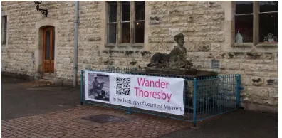
The nature of the experiences varied, including a tour of a country estate “in the footsteps” of an artist who painted scenes of estate life (engagement #2), locative art exhibitions (engagement #1 and #3), history tours (engagement #4-5) and an arts-oriented treasure hunt (engagement #6). The figures cited in the final column of Table 2 refer to the final stage of each engagement, and do not include earlier organised or ad-hoc tests. In addition, these figures do not report “false starts”, i.e. users who started to use the mobile client but stopped before finding any locative media.
Researchers carried out short semi-structured interviews with partners during the early stages of development, attended all organised tests (the final stages of engagements #1 and #4-6) and were present for regular full days of the public releases (in engagements #2-3). At organised tests, researchers carried out rapid feedback sessions, keeping field-logs, while during public releases researchers conducted semi-structured inter-views with consenting visitors, and a small number of walk-alongs (recording using video-capture glasses).
WANDER ANYWHERE
As an enabling technology for research with our target com-munity we developed a website that serves as a single point for authoring LBEs, accessing them (either via a desktop computer or via a location-aware mobile device), and review-inglogs of visitor’s experiences. The emphasis in designing
the website has been on ensuring that it is simple and – where possible – familiar, to encourage its use without our interven-tion.
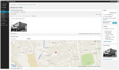
WordPress as authoring tool
The Wander Anywhere website3is based on the open source
WordPresscontent-management system (CMS), extended to allow authors to create both standard blog posts and geo-tagged blog posts via astandard web browser(see Figure 1).
Figure 1. Wander Anywhere authoring with geotagging functionality
By building on the most widely used web CMS4we ensure
that some potential authors arealready familiarwith the au-thoring interface. In our research engagements with 101 place experts who have used the website in the last three years, just over 20% had previously used their own or someone else’s WordPress CMS to create web content. For those without previous experience, the UI bore resemblance to other CMSes they had used (e.g. “to update our website at work”), or at worst allowed familiar operations such as the ability to copy-and-paste content into the visual WYSIWYG editor, and ap-ply formatting in a manner similar to familiar word process-ing software. The website allows authors to review the con-tent they have created, either in a familiar “blog” view or on a map.
HTML5 Mobile Client
Away from the desk, authors and end-users can experience the locative web content by pointing their own mobile devices at the same website and using the HTML5 mobile-friendly version. This mobile web client allows mobile users first to choose an LBE from a list of all those created through Wander Anywhere. Authors had the opportunity to advertise URLs that linked directly to specific LBEs: we discuss emergent strategies for using these URLs later in the paper. The mobile site then helps the user navigate to the nearest piece of geo-tagged content, offering a choice of three styles of navigation. Users could use a map, viewing their current location and that of the nearest piece. Alternatively users could request a com-pass bearing and distance to the nearest piece. Finally, users could view a “solar compass” that showed the direction of the
3
http://wanderanywhere.com/
4
[image:4.612.320.565.178.323.2]nearest piece in relation to the position of the sun (Figure 2, left). When the user reaches a trigger location, the mobile site reveals the content tagged with that location (Figure 2, right).
Figure 2. Wander Anywhere navigation between pieces of content
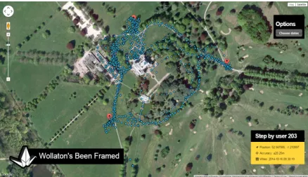
Data Logging and Review
[image:5.612.66.285.423.549.2]Taking inspiration from work such as [30, 5] that argued the benefits of revealing the work of infrastructure in LBEs, we added a simple analytic component to the website. While a visitor hunts for locative content using the mobile website, their location is logged, typically every 10 seconds, in order to update the directions presented by the mobile website. These traces are accessible in anonymised form to authors who may view them plotted on a map in relation to the locative media they have created (Figure 3).
Figure 3. Traces from mobile clients, plotted over locative media
FINDINGS FROM “THE WILD”
Having conducted our extended period of research with the cultural heritage sector, we are now in a position to draw out
recurring themesfrom our observations. These themes have emerged from analyses of qualitative data: researcher field-logs, recorded interviews and surveys collected from partic-ipants after design workshops. After significant collections of data (e.g. after workshops, and after periods of observa-tion during design engagements), members of the research team coded data. One researcher coded all data over the three years, while others contributed during shorter periods. In each case, researchers began with the set of codes used in
the previous coding session, introducing new codes as nec-essary, comparing codes and removing synonyms where pos-sible. Our focus over the course of the coding sessions has been to identify codes that recurred across workshops and design engagements. We present these recurring findings as themes. As data collection was often opportunistic and cod-ing was conducted over a long period, the results are illus-trative, rather than rigorously representative. We use quotes from the data to illustrate themes, attributing these to specific partners and research activities where appropriate.
Author expectations: what can we make?
Our place experts initial expectations came from their past experience of creating visitor offerings.
Our partners tended to quickly pick up the concept of the Wander Anywhere mobile client – “you only had to try it once to get that it’s like a sat-nav for web pages” [work-shop #1] – and there was a general expectation to create a
trailof content to discover and follow. Initial attempts were sometimes described confirmational (e.g. Figure 4) or indeed
boring: “I’m not sure why I put a photo of the locationat the location– it seemed like the obvious thing to try” [work-shop #1], but served the purpose of confirming that authors knew what they were doing. Partners in our design engage-ments enjoyed this familiar model:“we deal in linear routes; it helps us manage visitors and keep surprises to a minimum” [author, engagement #4]. On the other hand, some authors complained that Wander Anywhere tended to produce a par-ticular type of experience: “whatever you make, it ends up feeling similar. Now that I know what I’m doing, I can’t re-ally push the model beyond the ‘walk, find something, walk, find something else’ thing ...” [author, engagement #3]
Figure 4. Attendee testing an unsurprising LBE during workshop #3
[image:5.612.339.540.432.580.2]who went completely the wrong way” [author, engagement #3]. Others saw this as a risk: “two of us walked the same walk and got different triggers. We laughed, but it would be no good if we gave it out to real visitors” [workshop #3].
Some authors noted that the concept of hunting for content evoked a game-like feel: “it’s different to a guide book be-cause you can’t just flick to a page, and you don’t know what you’re heading towards; it’s definitely more like a game” [workshop #2]. Others designed their experienceas a game:
“ours is a story, but in the style of an adventure game: we want users to make choices outside by the way they move. We want them to feel like they could ‘go the wrong way’ and end up in a sticky situation” [workshop #3].
It should be noted that some also drew inspiration from the other LBEs posted on the Wander Anywhere website. This was particularly evident during the workshops, where au-thors had to quickly develop a concept –“it kick-started our brainstorm, but we had to be careful not to copy their ideas” [workshop #2]– but less so in the design engagements where the partners placed an emphasis on creating their own distinc-tive LBE:“I had fun looking at this other stuff, but I’ve got my own clear idea” [author, engagement #2].
The ever-present issue of mobile navigation
All three of the navigation styles offered by the mobile client were used extensively by the workshop participants and users during deployments. Observation of the design engagements suggests that users tend to choose the map view initially, try-ing other styles only after ensurtry-ing that they understood the map style. Visitors suggested that maps were familiar ways of navigating on mobiles: “it’s an obvious choice isn’t it? I use Google Maps almost everyday to drive, and I use it when I go somewhere unfamiliar” [visitor, engagement #2]. Hav-ing become familiar with one style, users tended to stick to that preferred option, although some visitors switched for fun:
“I tried the sun and compass modes for a laugh; I walked around in circles for a while – don’t judge me – but did feel like I’d really earned it when I found something!” [visitor, engagement #6]In two of the design engagements, our part-ners were keen for visitors to avoid the map, feeling that it
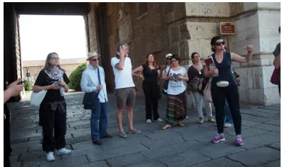
harmedthe experience:“I want paths toemergein response to the environment, not for visitors to just plot a route using the map” [author, engagement #3],“we’re all about the out-doors – we teach orienteering and ecology – I want visitors to learn something about using a compass through the expe-rience” [author, engagement #2]. In fact, in engagement #5 the authors preferred that visitors avoided looking at the mo-biles between trigger areas, as they were led on a predefined walk by an experienced tour guide (Figure 5).
Benefits and problems of “bring your own”
[image:6.612.343.541.61.178.2]Over the three years we have noted the spread of smart mobile devices. In workshop #1 and engagement #1 we had to lend suitable mobile phones to users regularly; since then we have been surprised by the range of devices that users have brought to workshops, or used as visitors during engagements. Cost was a benefit cited by our engagement partners:“it’s perfect
Figure 5. Predefined walk by expert tour guide, engagement #5
that visitors bring their own tech – we couldn’t countenance buying in handsets to give out” [author, engagement #3]
Despite many of these devices being compatible with the mo-bile website, the sheer variety has revealed issues. One such issue emerged during engagement #2. The LBE designed in this engagement was extensive: users who attempted to find all content typically spent over an hour walking the lo-cation. A significant minority of these users brought tablets, and found it difficult to carry and use them for this length of time:“I really enjoyed finding the early things, but my arms got really tired. I should’ve used a phone I suppose, but I thought it would be better on a tablet” [visitor, engagement #2].
In workshops #2-3 we rarely lent devices and participants tended to prefer forming groups to share each other’s de-vices instead. During engagements, partners had no dede-vices to lend, and so our understanding of the visitors’ devices is more anecdotal, but staff managing engagement #2 suggested that“I think it would be a mistake to give out mobiles to visi-tors who didn’t have them: what if something went wrong out in the estate? They wouldn’t know how to fix some random phone they’ve been given” [author, engagement #2]. It is worth noting that all workshop participants that had suitable smart devices also had a mobile contract with data allowance, and were happy to use this. Partners were keen to warn vis-itors in public tests and releases about mobile data usage to avoid issues later on:“I’m cautious about anything that might come back and bite us, since it’ll be me that has to deal with it. Our signage reminds visitors that this is the same as any other web browsing” [author, engagement #2].
Understanding mobile infrastructure
Figure 6. Video watching as another waits for buffering, workshop #3
Authors learnt about the impact of the physical environment on GPS both by testing their own LBEs and querying the an-alytical visualisations provided by Wander Anywhere. In ur-ban locations, authors noted obvious black-spots: “this lot laugh at me, but I didn’t know GPS didn’t work underground – trying to put content in the tunnel is a no-go then ...” [work-shop #2]In rural areas, the visualisations of visitors’ traces
revealed some surprises for authors: “we had some
com-plaints about some particular pieces – it’s only after we had a few traces on here that it becomes really obvious that the trees are causing an issue. Who knew?” [author, engagement #3]Authors learnt to anticipate and respond to environmental features: “weneedthe walkers to go down that street – it’s where the view is – but GPS is going to be bad. The buildings are very tall. I made the trigger area really large, so they’ll definitely hit it somewhere” [author, engagement #5].
In design engagements our partners also noted apparent ef-fects of weather on both positioning and data. Staff manag-ing engagement #2 recalled,“when it’s really hot and humid – when we get the most visitors walking out into the park – the phones seem to play up more than usual. Oddly, fresher days seem to give more reliability. I’m probably reading into it too much ...”. Other researchers have also noted the effects of the weather on mobile service [22].
Emerging local practice
Our design engagements revealed the way that place experts applied and adapted existing practices for the development of visitor activities. In particular we noted a common strategy for testing, with authors first testing a prototype themselves, then including colleagues, then members of the public. Only if a design passed these stages did the place experts deem it safe for “public release”.
Testing often had to fit around day-to-day work on locations. Initially, authors in engagement #2 attempted to conduct or-chestratedtest sessions with colleagues, helping them to use their mobiles to find Wander Anywhere and then the LBE, and noting issues as the testers “spoke aloud” their user expe-rience. As we attempted to observe these sessions we found that they became increasinglyad-hoc, as described by this member of staff: “because we’re spread around the Estate it’s actually damn nigh impossible to know when we might be able to get a group together. We can’t just shuffle our schedules around – we’re all busy. Sometimes it just hap-pens though, and it’s been so useful to say: just get your phone out and try this ...” [author, engagement #2]. The
ease with which the content could be edited supported this ad-hoc approach, with staff making immediate changes post-test: “I don’t carry a pad and pen around with me all the time, so if I didn’t go and fix something straight away I’d probably forget!” [author, engagement #2]. In engagements #2 and #3, initial authors saw internal tests as a way to en-thuse colleagues:“it’s always the way – everyone’s a skeptic until you actually show them something, then they suddenly want a piece of the action” [author, engagement #6].
Public testing was a familiar activity for some of our part-ners, who were used to evaluating new public engagement activities. After leading tests in engagement #4, one author explained,“we always have to demonstrate the value of new activities to justify ourselves to our funders – we have a struc-ture for evaluations that we know well, and it has worked fine for these walks”. This was echoed by partners in engagement #3: “I know what [a funder] wants to hear, so I’m used to asking particular questions during tests”. Indeed, some of our partners had user groups on hand to test new activities, and drew on these groups during the design engagements:“I can mobilise representative subjects quickly – they’ve tried enough of our ideas to be critical, but at the same time get where we’re trying to go and be constructive” [author, en-gagement #2].
Making first contact happen
We saw evidence that getting access to an LBE for the first time via the mobile website could prove difficult for some users. This was less true in the workshops, where the re-searchers demonstrated how to use the mobile website at the start of the session. In the long-term design engagements, our partners were responsible for making their LBEs accessible to visitors – it became evident that this was not trivial in early tests. Location staff in engagement #2 conducted facilitated trials with “friendly” groups of visitors (i.e. staff family and friends), and helped each tester launch the browser on their mobile, enter the toolkit’s URL and find the correct LBE in the mobile client. During these trials, staff noted that the sim-ple step of navigating to a URL in the mobile web-browser, which they had learnt quickly and carried out hundreds of times since, was problematic for many visitors. One frus-trated staff facilitator related his findings to us:“we didn’t re-ally think about it, but people tend to Google for web-pages – they aren’t used to typing in an address. If what they’re look-ing for isn’t top of the search results, they get stuck. ‘Type in a URL’ just doesn’t compute” [author, engagement #2]. In other engagements, it was noted that if visitors did attempt to find a specific LBE via the list in the mobile client, they might be tempted to try one of the others instead:“it’s distracting – we reckon some people are getting lost before they even find our content” [author, engagement #3].
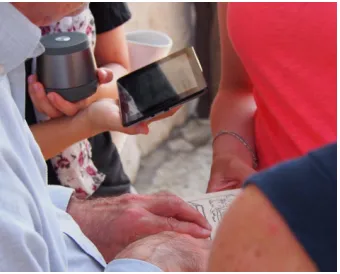
In response to these difficulties, our partners were quick to experiment with ways of avoiding or simplifying the process of accessing an LBE. In engagements #2 and #4-6, the URL for specific LBEs were encoded in QR codes and tested (e.g. Figure 7).
Figure 7. QR code as an access point for the LBE, engagement #2
a barcode app, they sort of understood what the purpose was and wanted to find out what it did. We saw parents encour-aging kids to get an app to scan it” [author, engagement #2], and seemed pleased that“it’s point-and-shoot – really easy – as long as they’ve got the right app” [author, engagement #2]. Authors also explored alternative schemes that were more in keeping with their location. There were some con-cerns voiced by staff and visitors about the aesthetics of QR codes, and their impact on the local environment; one visitor to the location stated that“it sticks out like a sore thumb here next to these lovely old buildings; I’d rather it wasn’t here on full view” [visitor, engagement #2]. In workshop #2 and en-gagement #6 authors testedAestheticodes[28] as an scheme that provides creative freedom and the opportunity to make the code “invisible”: “QR codes are plain ugly – and don’t give any hint at what they do – the sign should reflect what you’re about to set in motion” [workshop #2].
Spreading the LBE
Building on the earlier aesthetic concerns, staff in engage-ment #2 refused to consider putting out advertising for the experience into the parkland. Instead, opportunities to hide adverts for the experience and use other visitors as the vector were explored, inspired by some of the staff’s knowledge of
geocaching. Caches of small paper tokens were placed in the parkland at two locations that were used in the LBE. The LBE drew visitors to these hidden caches, where they were encour-aged to leave a thought in the paper logbook in the cache, take a ream of tokens, and pass them on to other visitors. The to-kens included the URL for Wander Anywhere and – depend-ing on the design – the QR code for the LBE. The caches grew as visitors decided to leave more than simply a thought, depositing objects they had found on their walk as well as geocaching coins. One interviewed visitor commented on the effect of the cache:“I didn’t know there was such a thing as geocaching, but it’s a great idea. I really want other people to go and find that collection of thoughts, particularly now I’ve added to it. It turns these stickers [the tokens] into more than just a piece of stealth promotion. More like I’m inviting someone in ...” [visitor, engagement #2]
In engagement #3, our observations of mobile users revealed a number of casual interactions occurring between visitors out on location. Mobile users’ interactions with their de-vices drew attention and sometimes conversation: “I think they wondered why I was laughing at my phone and trying to climb into the bushes. I had to explain that I was trying
to find hidden stuff, just to prove I wasn’t crazy” [visitor, en-gagement #3]. This conversation sometimes led to sharing:
“I think people don’t want to be left out. I could see their kids trying to see what I was looking it, so I told their parents how to find the website” [visitor, engagement #3].
Digital footprints and design heuristics
Wander Anywhere’s analytic visualisation was a source of in-terest during workshops and design engagements. In shops, participants liked the graphical way in which the work-ings of mobile technology were revealed. They could clearly see the accuracy of GPS positioning and its effect on their ability to discover map posts, and make inferences about the way in which other participants had moved during explo-rations: “even if I didn’t know where the paths were in the park, I could sketch them based on these dots” [workshop #1]. Authors noted how points in the visualisation clustered at the start of experiences:“the shopping centre is so obvious – all these points are from us all standing around waiting for our phones to kick in” [workshop #2]. One attendee at work-shop #3 - an expert employed at a country estate popular with visitors - stated“one of our biggest issues is trying to spread visitors more evenly around the estate, particularly out into the park: we design activities to change the flow of visitors”. The same participant suggested that understanding the flow of visitors would be highly valuable when redeploying assets such as signage and cafes, or targeting conservation efforts.
Authors went as far as to suggest that these “digital foot-prints” might also make a compelling visitor experience. Af-ter prompting by early workshop participants, we developed a live visualisation of traces for workshop #3: this provoked discussion around its“game-like feel”. A similar visualisa-tion was developed during engagement #2, and displayed as an projected installation in the location’s visitor centre. Staff commented that,“the projection seemed to get more atten-tion than the experience itself! It definitely encouraged some visitors to try out the [LBE], I think because it showed them where they should go”. Place experts also suggested that the footprints might make goodsouvenirs:“I think we could sell a personalised map based on their data – visitors could see what they missed, and come back again to do the other bits of a site” [author, engagement #6].
loca-tions. We ended up filling in long distances with ‘filler’ con-tent just to maintain atcon-tention”.
Appropriation and creativity
[image:9.612.92.262.336.473.2]Authors made unexpected uses of the capabilities of Wan-der Anywhere, pushing the system beyond the simple multi-media model introduced at the start of workshops. Authors quickly began to experiment with embedded media and wid-gets to overcome the lack of options for interactivity in the basic Wander Anywhere editor. In workshops #2-3, partic-ipants embedded Twitter streams in geotagged posts, along with instructions for users to tweet a message with a particu-lar hashtag. This allowed mobile users to leave messages for other users to find, on location. Authors experimented with widgets from other popular social media and user-generated content services, looking for suitable widgets to allow photos to be uploaded and viewed: “it’s fun to explore all the op-tions – most of them don’t quite work in the mobile site – they seem to break the layout or be a bit clunky, but it shows you what is possible” [workshop #2]. The link with social media was seen as key:“Twitter and Facebook are our lifeline right now – they’re how we get to younger visitors, so getting in-tegration with them into this experience is really beneficial” [author, engagement #4].
Figure 8. Using wireless speakers and relief sketches, engagement #5
Our partners also experimented with ways of using other tools alongside the mobile device. In engagement #2, a set of real compasses and paper maps were provided for visitors to use with the mobile website as a means of making the compass bearing style of navigation more appealing:“on one hand it makes the compass points easier for people who don’t really do bearings; on the other it gives everyone in a family some-thing to hold and contribute – we had a lot of fun!” [vis-itor, engagement #2]In engagement #5, a core aim of the design was to cater for visitors with limited vision: the au-thors catered for this by providing Bluetooth speakers so that groups could all hear locative audio content, and paper 3D reliefs of the locative images so that visitors could “feel” the images displayed by the mobiles (see Figure 8).
DISCUSSION AND IMPLICATIONS
Through three workshops and six longer-term design re-lationships we have observed how place experts have ap-proached the creation of LBEs. We have observed four com-mon stages in this process of enquiry, and over the three
years we have refined our own processes and tools to sup-port this engagement by place experts with LBEs. Through these commons stages of equiry we draw together our ob-servations and resulting implications for both processes and technologies (labelled Pnand Tn, respectively).
1. Comprehension
In this first stage place experts with no experience of develop-ing location-based mobile experiences sought to answer ques-tions such as“what is it?”,“what can it do?” and“should I spend more time learning how to use it?”. The “make-and-do” workshops facilitated this initial enquiry, allowing place experts to develop a basic understanding of the nature of LBEs and how they can be created. This initial stage typi-cally involved creating mobile equivalents of familiar visiting experiences, e.g. guided information walks.
P1: Prefer facilitated discovery over information delivery for initial comprehension. We found that guided hands-on “trial-and-error”, especially on a site where place experts will encounter design obstacles, gives place experts rapid insights into LBE design and technology limitations, and also em-beds the habit of real-world testing into their emerging design practice. Exploration alongside other place experts – includ-ing peer critique – accelerates this process of discovery.
T1: Provide a familiar and immediate interface for ini-tial use. At this stage it is important that the tools minimise barriers to initial use. Ideally place experts should be able to use their own computers and mobiles. It should be as fast as possible to get started. The interface should use familiar metaphors and interaction, e.g. WYSIWYG editing. And “one click” publishing should allow place experts to deploy a first design within minutes.
2. Translation
At the end of a workshop place experts typically progressed to questions such as“will this work just as well when I try it at home?” and“can I really do this on my own?”. The workshops were conducted on sites that could be considered as generic tourist locations but differed significantly from the specific sites managed by the attendees, so that place experts now had totranslatetheir initial discoveries and understand-ing to their own “place”. This typically involved a period of self-led experimentation with little or no involvement from colleagues or visitors, which had to be fitted around existing demands on their time.
P2: Provide clear and actionable prompts for follow-up activities.Simple structured tasks such as rebuilding experi-ences developed in workshops on their own site enable place experts to begin to relate their knowledge of their own site to their growing understanding of LBEs. Often place experts will also need continued support in this process.
T2: Support exploratory prototyping anywhere, anytime.
3. Development
Place experts often moved on to ask questions such as“what will be useful for our site?”,“who needs to be involved in de-velopment?”and“which of our visitors are able and willing to use the LBE?”. This reflected a general shift from self-directed experimentation towards more rigorous testing and refinement of their LBEs. This ranged from ad-hoc testing and demonstration to other stakeholders within the place ex-perts’ organisations to more formal tests with visitors.
P3: Encourage the progression from exploration to rigour. Place experts and their organisations often have ex-isting protocols for trialling visitor activities. But researchers can also contribute valuable insights into conducting field tri-als with technology, as well as the common challenges and opportunities of LBEs.
T3: Support collaborative development. It is important that the original place expert can involve other people in the development process. They are becoming experienced LBE authors, but colleagues and other stakeholders will almost al-ways have valuable or even essential contributions to make.
T4: Support trials and evaluation.To develop a good LBE it is important to do regular tests and trials, including with po-tential end-users (visitors). Authoring and development tools should make it easy to run trials, and also to review and anal-yse the results of those trials, e.g. through suitable visual-isations. These tools may also explicitly reveal predictable effects – GPS shadows, etc. – that were, in stages 1-2, left for place experts to discover.
T5: Support integration with the visiting ecosystem. The LBE in development is almost never the only activity at that site. The tools should allow for the LBE to be tailored and integrated with the other apps, technologies and experiences that visitors will engage with on the same site and visit.
4. Approval and Public Release
Finally the place expert – or their organisation – may ask“is this good enough for public release?”. An established site will not launch and promote a LBE to a large proportion of its visitors unless it is confident that it will work reliably, re-flect positively on the site or organisation and not undermine the experience of those or other visitors. This reflects a sig-nificant transition from prototype to “production”.
P4: Respect the approval processes.In many organisations there will be established processes for managing this kind of transition. Many of the considerations are non-technical, for example cost and projected use. There are also a range of non-functional characteristics of the LBE that will often be pre-requisites for making this transition, in particular relia-bility, availarelia-bility, branding, security and in some cases the ability to monetise the experience.
T6: Support the transition from development to product.
If the system that was used to design the LBE is also to de-liver the public experience then it will need to satisfy various specific non-functional requirements as noted above. Alter-natively a different system or technology may be used for the public version of the experience, in which case the tools used
in the earlier stages should allow assets and ideally the com-plete design to be exported to the production system.
Reflecting on Wander Anywhere, we have seen the website develop to effectively support stages one to three of this pro-cess. The choice to use web for authoring and experience, and in particular the well-known WordPress CMS, creates a familiar and immediate first encounter (T1), allowing place experts to use their own laptops and mobiles to create, de-ploy and test their first LBE within 30 minutes. By being able to take their devices back to their own sites and continue to access the same web tools, place experts are then able to translate their initial learning (T2). We saw sustained periods of development supported by: the ability for place experts to addnewauthors and collaborators (T3), the data logging and review component (T4), and the ability to integrate other web services, e.g. through social media widgets (T5).
Many attendees of our workshops sought simply to under-stand LBE technologies, and a full public release was never a goal:“it’ll be years before we can actually get to this, but we now know what “it” is” [workshop #2]. The place ex-perts in the two long term engagements (#2-3) thatdidreach public release had relaxed requirements about the branding of the final experience, content protection or monetisation. But other place experts did not consider Wander Anywhere to be suitable as the delivery platform for a production LBE, for ex-ample because it did not support extensive customisation of the look-and-feel of the mobile client, and the communal na-ture of the site means that it is difficult to make LBE content or design private from other place experts. Some place ex-perts also disliked the user experience provided by a mobile web client: “it’s a great prototype [...] but it’s not got the polish we need” [author, engagement #4]. However, Wander Anywhere does provide both an API that can serve locative media to 3rd-party clients as well as export content for use in a more suitable production client (T6).
CONCLUSION
Working with place experts through a series of workshops and longer-term engagements we have found that their explo-ration of LBEs typically progresses through four stages: com-prehension, translation, development and approval for public release, each of which has distinct implications for the pro-cesses and technologies that support it. We conjecture that a similar pattern may be seen with other ubicomp technologies. We have found that Wander Anywhere, partly as a result of its use of web technologies, has effectively supported the first three of these stages. However it has limitations as a solution for the fourth stage, public release, and a transition to other technologies and platforms may be more appropriate at this stage. Our next steps in development are to improve support for the development stage, in particular providing additional insight in the data logging and review component, e.g. high-lighting common paths (T4).
ACKNOWLEDGEMENTS
REFERENCES
1. Ballagas, R. A., Kratz, S. G., Borchers, J., Yu, E., Walz, S. P., Fuhr, C. O., Hovestadt, L., and Tann, M.
Rexplorer: A mobile, pervasive spell-casting game for tourists. InCHI ’07 Extended Abstracts on Human Factors in Computing Systems, CHI EA ’07, ACM (New York, NY, USA, 2007), 1929–1934.
2. Barnard, L., Yi, J. S., Jacko, J. A., and Sears, A. Capturing the effects of context on human performance in mobile computing systems.Personal Ubiquitous Comput. 11, 2 (Jan. 2007), 81–96.
3. Bedwell, B., Schn¨adelbach, H., Benford, S., Rodden, T., and Koleva, B. In support of city exploration. In
Proceedings of the SIGCHI Conference on Human Factors in Computing Systems, CHI ’09 (2009), 1171–1180.
4. Bellotti, V., Begole, B., Chi, E. H., Ducheneaut, N., Fang, J., Isaacs, E., King, T., Newman, M. W., Partridge, K., Price, B., Rasmussen, P., Roberts, M., Schiano, D. J., and Walendowski, A. Activity-based serendipitous recommendations with the magitti mobile leisure guide. InProceedings of the SIGCHI Conference on Human Factors in Computing Systems, CHI ’08 (2008), 1157–1166.
5. Benford, S., Crabtree, A., Flintham, M., Drozd, A., Anastasi, R., Paxton, M., Tandavanitj, N., Adams, M., and Row-Farr, J. Can you see me now?ACM Trans. Comput.-Hum. Interact. 13, 1 (Mar. 2006), 100–133.
6. Benford, S., Seager, W., Flintham, M., Anastasi, R., Rowland, D., Humble, J., Stanton, D., Bowers, J., Tandavanitj, N., Adams, M., Farr, J., Oldroyd, A., and Sutton, J. The error of our ways: The experience of self-reported position in a location-based game. In
UbiComp 2004: Ubiquitous Computing, N. Davies, E. Mynatt, and I. Siio, Eds., vol. 3205 ofLecture Notes in Computer Science. 2004, 70–87.
7. Bentley, F., and Basapur, S. Storyplace.me: The path from studying elder communication to a public location-based video service. InCHI ’12 Extended Abstracts on Human Factors in Computing Systems, CHI EA ’12, ACM (New York, NY, USA, 2012), 777–792.
8. Bentley, F. R., Basapur, S., and Chowdhury, S. K. Promoting intergenerational communication through location-based asynchronous video communication. In
Proceedings of the 13th International Conference on Ubiquitous Computing, UbiComp ’11, ACM (New York, NY, USA, 2011), 31–40.
9. Bowser, A. E., Hansen, D. L., Raphael, J., Reid, M., Gamett, R. J., He, Y. R., Rotman, D., and Preece, J. J. Prototyping in place: A scalable approach to developing location-based apps and games. InProceedings of the SIGCHI Conference on Human Factors in Computing Systems, CHI ’13 (2013), 1519–1528.
10. Buchenau, M., and Suri, J. F. Experience prototyping. In
Proceedings of the 3rd Conference on Designing Interactive Systems: Processes, Practices, Methods, and Techniques, DIS ’00 (2000), 424–433.
11. Chamberlain, A., Crabtree, A., Davies, M., Glover, K., Reeves, S., Tolmie, P., and Jones, M. Placebooks: Participation, community, design, and ubiquitous data aggregation ‘in the wild’. InProceedings of the 15th International Conference on Human Interface and the Management of Information: Information and Interaction Design - Volume Part I, HCI International’13 (2013), 411–420.
12. Cheverst, K., Davies, N., Mitchell, K., and Friday, A. Experiences of developing and deploying a
context-aware tourist guide: The guide project. In
Proceedings of the 6th Annual International Conference on Mobile Computing and Networking, MobiCom ’00 (2000), 20–31.
13. Crabtree, A. Design in the absence of practice: Breaching experiments. InProceedings of the 5th Conference on Designing Interactive Systems:
Processes, Practices, Methods, and Techniques, DIS ’04 (2004), 59–68.
14. de S´a, M., and Carric¸o, L. Lessons from early stages design of mobile applications. InProceedings of the 10th International Conference on Human Computer Interaction with Mobile Devices and Services, MobileHCI ’08 (2008), 127–136.
15. Dey, A., Sohn, T., Streng, S., and Kodama, J. icap: Interactive prototyping of context-aware applications. In
Pervasive Computing, K. Fishkin, B. Schiele, P. Nixon, and A. Quigley, Eds., vol. 3968 ofLecture Notes in Computer Science. 2006, 254–271.
16. Dey, A. K., Abowd, G. D., and Salber, D. A conceptual framework and a toolkit for supporting the rapid prototyping of context-aware applications.
Hum.-Comput. Interact. 16, 2 (Dec. 2001), 97–166.
17. Do, T. V., Cheverst, K., and Gregory, I. Lomak: A framework for generating locative media apps from kml files. InProceedings of the 2014 ACM SIGCHI
Symposium on Engineering Interactive Computing Systems, EICS ’14 (2014), 211–216.
18. Dow, S., MacIntyre, B., Lee, J., Oezbek, C., Bolter, J. D., and Gandy, M. Wizard of oz support throughout an iterative design process.IEEE Pervasive Computing 4, 4 (Oct. 2005), 18–26.
19. Durrant, A., Rowland, D., Kirk, D. S., Benford, S., Fischer, J. E., and McAuley, D. Automics: Souvenir generating photoware for theme parks. InProceedings of the SIGCHI Conference on Human Factors in
Computing Systems, CHI ’11 (2011), 1767–1776.
20. Flintham, M., Greenhalgh, C., Lodge, T., Chamberlain, A., Paxton, M., Jacobs, R., Watkins, M., and Shackford, R. A case study of exploding places, a mobile
21. Greenhalgh, C., Benford, S., Drozd, A., Flintham, M., Hampshire, A., Oppermann, L., Smith, K., and von Tycowicz, C. Addressing mobile phone diversity in
ubicomp experience development. InUbiComp 2007:
Ubiquitous Computing, J. Krumm, G. Abowd,
A. Seneviratne, and T. Strang, Eds., vol. 4717 ofLecture Notes in Computer Science. 2007, 447–464.
22. Han, D., Han, J., Im, Y., Kwak, M., Kwon, T. T., and Choi, Y. Maserati: Mobile adaptive streaming based on environmental and contextual information. In
Proceedings of the 8th ACM International Workshop on Wireless Network Testbeds, Experimental Evaluation & Characterization, WiNTECH ’13 (2013), 33–40.
23. Hull, R., Clayton, B., and Melamed, T. Rapid authoring of mediascapes. InUbiComp 2004: Ubiquitous Computing, N. Davies, E. Mynatt, and I. Siio, Eds., vol. 3205 ofLecture Notes in Computer Science. 2004, 125–142.
24. Hutchinson, H., Mackay, W., Westerlund, B., Bederson, B. B., Druin, A., Plaisant, C., Beaudouin-Lafon, M., Conversy, S., Evans, H., Hansen, H., Roussel, N., and Eiderb¨ack, B. Technology probes: Inspiring design for and with families. InProceedings of the SIGCHI Conference on Human Factors in Computing Systems, CHI ’03 (2003), 17–24.
25. Lane, G. Urban tapestries: Public authoring, place & mobility. Tech. rep., Proboscis, 2006.
26. Li, Y., Hong, J. I., and Landay, J. A. Topiary: A tool for prototyping location-enhanced applications. In
Proceedings of the 17th Annual ACM Symposium on User Interface Software and Technology, UIST ’04 (2004), 217–226.
27. Long, S., Kooper, R., Abowd, G. D., and Atkeson, C. G. Rapid prototyping of mobile context-aware applications: The cyberguide case study. InProceedings of the 2Nd Annual International Conference on Mobile Computing and Networking, MobiCom ’96 (1996), 97–107.
28. Meese, R., Ali, S., Thorne, E.-C., Benford, S. D., Quinn, A., Mortier, R., Koleva, B. N., Pridmore, T., and
Baurley, S. L. From codes to patterns: Designing interactive decoration for tableware. InProceedings of the SIGCHI Conference on Human Factors in
Computing Systems, CHI ’13 (2013), 931–940.
29. OECD.Measuring the Digital Economy. OECD
Publishing, 2014, ch. Investing in smart infrastructure.
30. Oppermann, L., Broll, G., Capra, M., and Benford, S. Extending authoring tools for location-aware
applications with an infrastructure visualization layer. In
Proceedings of the 8th International Conference on Ubiquitous Computing, UbiComp’06 (2006), 52–68.
31. Oppermann, L., Flintham, M., Reeves, S., Benford, S., Greenhalgh, C., Marshall, J., Adams, M., Farr, J. R., and Tandavanitj, N. Lessons from touring a location-based experience. InProceedings of the 9th International Conference on Pervasive Computing, Pervasive’11 (2011), 232–249.
32. Pittarello, F., and Bertani, L. A software infrastructure for managing the lifecycle of context-aware stories. In
Proceedings of the 12th International Conference on Interaction Design and Children, IDC ’13 (2013), 523–526.
33. Raper, J., Gartner, G., Karimi, H., and Rizos, C. Applications of location-based services: A selected review.J. Locat. Based Serv. 1, 2 (June 2007), 89–111.
34. Rennick-Egglestone, S., Roussou, M., Brundell, P., Chaffardon, C., Kourtis, V., Koleva, B., and Benford, S. Indoors and outdoors: designing mobile experiences for cit´e de l’espace.Proc. NODEM(2013), 89–97.
35. Schn¨adelbach, H., Hale, J., Dorner, W., Bedwell, B., Benford, S., and Mardell, J. Future garden. In
Technologies for Interactive Digital Storytelling and Entertainment, S. G¨obel, R. Malkewitz, and I. Iurgel, Eds., vol. 4326 ofLecture Notes in Computer Science. 2006, 346–351.
36. Schuler, D., and Namioka, A., Eds.Participatory Design: Principles and Practices. L. Erlbaum Associates Inc., 1993.
37. Taylor, N., Cheverst, K., Fitton, D., Race, N. J. P., Rouncefield, M., and Graham, C. Probing communities: Study of a village photo display. InProceedings of the 19th Australasian Conference on Computer-Human Interaction: Entertaining User Interfaces, OZCHI ’07 (2007), 17–24.
38. Weal, M. J., Hornecker, E., Cruickshank, D. G., Michaelides, D. T., Millard, D. E., Halloran, J., De Roure, D. C., and Fitzpatrick, G. Requirements for in-situ authoring of location based experiences. In
Proceedings of the 8th Conference on Human-computer Interaction with Mobile Devices and Services,
MobileHCI ’06 (2006), 121–128.
39. Weise, S., Hardy, J., Agarwal, P., Coulton, P., Friday, A., and Chiasson, M. Democratizing ubiquitous computing: A right for locality. InProceedings of the 2012 ACM Conference on Ubiquitous Computing, UbiComp ’12 (2012), 521–530.
40. Wetzel, R., Blum, L., and Oppermann, L. Tidy city: A location-based game supported by in-situ and web-based authoring tools to enable user-created content. In