The soil-terrain modelling has been widely de-veloped in the last few decades. Topography is one of the main pedogenetic factors identified by many soil scientists (Dokuchaev 1892; Jenny 1941; Gerrard 1981). The McBratney’s Scorpan model (2003) has been together with other methods as geostatistics, a background for pedometrical methods development. Pedometrics represents a large set of quantitative tools, models, and ap-proaches describing soil variation, heterogeneity, and behaviour in landscape.
Quantitative information on the relief is often used in the soil studies including modelling and prediction of the soil properties (Moore et al.
1993), whose range is relatively wide. The properties most often investigated are: thickness of horizons (McKenzie & Ryan 1999; Florinsky et al. 2002), soil depth (Odeh et al. 1995; Penížek & Borůvka 2006), particle size distribution (Odeh et al. 1995), the amount of skeleton, humus content (McKenzie & Ryan 1999), moisture or hydromorphic features (Mummery et al. 1999). The terrain attributes can be directly used for studying the relationship with the soil properties, another possibility is to use the terrain units based on the classification and integration of the terrain characteristics.
Quantitative topographic data have been used in the form of digital terrain models (DTMs) for the
Supported by the Ministry of Education, Youth and Sports, Project No. MSM6046070901 and by Czech Science Foundation, Project No. 526/06/1182.
Soil-terrain Modelling and Erosion Analysis at Field Scale
Level, a Case Study
Tereza ZádoRová, Lukáš BRodSký and Marcela Rohošková
department of Soil Science and Soil Protection, Faculty of Agrobiology, Food and
Natural Resources, Czech University of Life Sciences in Prague, Prague, Czech Republic
Abstract: Pedometrical methods and digital soil mapping represent a progressive approach to the evaluation of various terrain-related soil processes. A detailed digital terrain model was used for the analysis of erosion – sedimentation situation and description of specific soil properties at meso-relief scale. A study plot in Central Bohemia (area 4 ha) with highly diversified geological conditions was chosen for the study combining digital modelling with a detailed terrain survey and laboratory analysis. The curvature and topographic wetness index values were the main features for the accumulation and soil loss areas evaluation. The terrain survey and DTM results corresponded in the case of the soil cover structure and soil depth, showing a vast impact of acceler-ated water erosion and direct tillage erosion on the soil redistribution. In the concave and base slope positions, colluvial soils were identified, while Regosols with A–C profile stratigraphy form in the upper convex parts of the study plot. Particular soil properties distribution (pH, organic carbon content, texture) is, besides erosion, significantly influenced by parent rock variation and the relation to the terrain characteristics is less distinctive. The study showed a significant impact of the terrain properties on the general material redistribution and the possibility of soil cover structure prediction in areas with complicated geological conditions.
past two decades (Moore et al. 1993; McBratney et al. 2003). DTM considers both simple elevation data and many variables (Wilson & Gallant 2000) – primary terrain attributes (slope, curvature, aspect, specific catchment area) and secondary (derived) ones (TWI – topographic wetness index as the most common).
One of the most extended practical applications concerning the terrain modelling is the utilisation of DTM in pedological studies on soil erosion and its prediction (e.g. Moore et al. 1993; McBrat-ney et al. 2003). DTM is widely used mostly in the prediction of erosion vulnerability of an area. Thus, DTM is often a part of the model of the soil loss by erosion (Wischmeier & Smith 1978; Odeh et al. 1995; Martínez-Casasnovas et al. 2002). Recently, it has been applied in studies regarding the statistical dependence of the soils properties changes on the terrain characteristics (McKenzie & Ryan 1999; Florisky et al. 2002; De Gryze et al. 2008). The slope, curvature, and TWI are the most frequent predictors derived from the auxiliary data, all greatly influencing the surface runoff (Pennock 2003; Wilkinson & Humphreys 2006; Zádorová et al. 2008).
Besides the water erosion, the tillage erosion is a process that significantly influences the soil mass translocation. The tillage erosion has been studied for last two decades (Van Oost et al. 2005). In last years, a few simulation models were created focused on the connection between the tillage erosion and topography. The most relevant are SORET (De Alba 2003) and WATEM (Van Oost et al. 2005), all based on the algorithms derived from DTM.
This paper is focused on complex terrain analysis and soil characterisation by means of pedometrical methods for the study of erosion and sedimentation processes on the selected field with a long-term tillage practice.
MAtEriAL And MEthodS
Study area
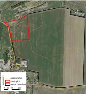
A detailed research was carried out on the study plot (strip part of an agricultural site, area 4 ha) in Chrášťany cadaster (Figure 1). The terrain on the relatively small study plot is highly fragmented. The main slope is divided by two main lateral
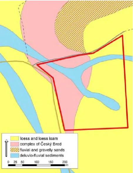
[image:2.595.66.368.428.756.2]leys representing the lines of concentrated runoff emptying into a wide colluvial fan. Geologically, three main units neighbour on the study plot (Basic geological map of the Czech Republic 1:25 000). The eastern part of the plot is formed by loess and loess loam, while the Paleozoic complex of Český Brod (schist, claystone, conglomerate, chert) emerge in the western part. The two side chan-nels are composed of delluvio-fluvial gravel and sand (Figure 2). The elevation between the side branches is formed on quaternary alluvial terrace. The soil unit variation corresponds to various par-ent rocks. Haplic Luvisol and Chernozem, eroded on the steeper slopes, are the dominant soil types. The parcel is under long-term tillage.
Methods
The plot was investigated by soil sampling based on irregular networks of borings (80 borings, depth 1 m, gouge auger Eijkelkamp). Each boring was lo-cated by DGPS device. In the field, the samples were analysed for the following morphologic features: soil profile stratigraphy, soil type, soil depth, humic horizon depth, soil colour (according to Munsell
charts), physical characteristics (texture evalua-tion, soil skeleton %). From each core, soil samples were taken for analysis. The samples were analysed for the grain size distribution, organic C content, carbonates content, and pH in calcium chloride (Sparks 1996). In the representative slope posi-tions, three pits were digged up to a depth of 1.2 m. The samples from each horizon were analysed, in addition to the characteristics above also for CEC and percent base saturation (Sparks 1996).
The terrain properties were obtained from the digital terrain model (DTM). The DTM was derived by ordinary kriging interpolation procedure from dense DGPS measurements. 150 DGPS measure-ments in centimetre vertical resolution were col-lected. The digital terrain model and its derivations (slope, curvature, hydrological indexes) were calcu-lated using integrated algorithms implemented in the ArcGIS 9.2 software, and by dedicated scripts in Ilwis 3.2. software (Hengl et al. 2003).
rESuLtS And diSCuSSion
Detailed analyses of the soil properties distribu-tion and erosion – sedimentadistribu-tion situadistribu-tion on the study plot using digital terrrain model were car-ried out. In addition to the relief factor, extremely various geological conditions on the site and the considerable impact of tillage erosion must be taken into account when discussing the results.
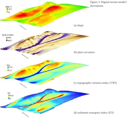
[image:3.595.64.291.441.736.2]Using the digital terrain modelling, the lines of concentrated runoff and parts of slope pre-disposed for the soil loss and accumulation were evaluated. For the determination of erosion and sedimentantion relations within the slope system, the following morphometrical properties were investigated (Figure 3): slope, plan and profile curvature, topographic wetness index (TWI), stream power index (SPI), sediment transport index (STI) (Florinsky et al. 2002; Hengl 2003). Especially the hydrologic properties, represent-ing the water and particles movements, relatively clearly delimitated the potential area of the mate-rial loss and accumulation. The areas of increased accumulation, delineated especially by high values of TWI in combination with the negative plan curvature (Penížek & Borůvka 2006; Seidel & Mäckel 2007; Zádorová & Penížek 2008) are concentrated in the concave lateral valleys and in the deluvial cone in the slope base (Figure 4). It was proved that the upper slopes showed a high
erosional vulnerability due to the higher slope and convex curvature. Increases of the soil depth and other characteristics (Corg content, pH, clay content) are an expected feature proved in other studies (Florinsky et al. 2002; Papiernik et al. 2008; Zádorová et al. 2008).
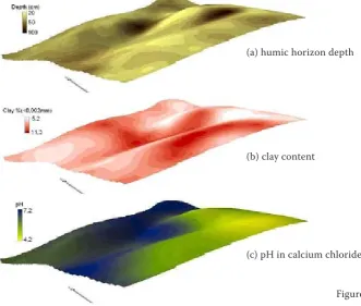
The terrain sampling and analyses results showed several facts corresponding relatively well with the predictive model. In Figure 5, the soil properties distributions (humic horizon depth, Corg, clay content, pH) interpolated by ordinary kriging method are presented. The soil depth obviously increases in concave parts of the slope, especially in the lateral valleys where the humic horizon depth reaches up to 1 m and the accumulated Chernozems and colluvial soils develop (Figure 4). An intensive accumulation in side valleys, caused mostly by a decrease of the runoff power with the change of slope, has been noted in several studies
(Lal 2001); Shmidt & Rodzik 2006; Zádorová et al. 2008). In the parts with convex curvature and a higher slope, the soil profile is influenced by accelerated erosion which results in A–C profile (Regosols) development (Figure 5a).
Considering the clay content changes within the slope, a high increase is reported at the nection spot of two lateral valleys. On the con-trary, at the colluvial cone on the slope base, a clay content decrease is evident (Figure 5b). The fan surface is visibly covered with a thin layer of mineral material (silt), accumulated after inten-sive rainfall episodes. Terhorst (2000) identifies similar colluvial layers on the valley floors in the south-west Germany loess region. In addition, this fact results in a relatively low organic carbon content in lower parts of the slope.
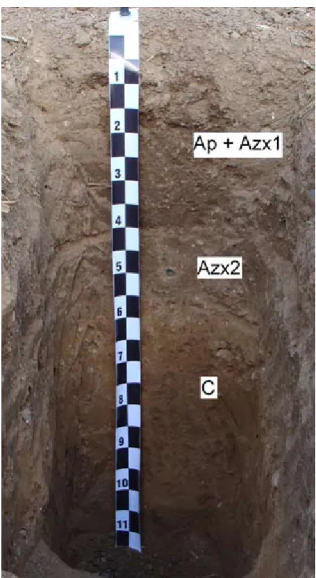
[image:4.595.64.505.82.490.2]A sudden accumulation episode of the mineral material in history is clearly visible in the profile
Figure 3. Digital terrain model (DTM) derivations
(a) slope
(b) plan curvature
(c) topographic wetness index (TWI)
stratigraphy of pit 3, where two humic horizons are separated by 5 cm thick layer of sand (Figure 6). The layer has not been interfused into the plough layer which means that the material can have been accumulated before the start of the tillage prac-tices. Upon this stratum, which probably buries the original humic horizon, a humic colluvial layer
[image:5.595.68.346.89.339.2](depth 0.4 m) has developped due to an intensive water and tillage erosion. The distribution of pH results from both soil loss and geological variation of the parent material (Figure 5c). In the upper parts, the subsoil is exposed and soil pH varies in the dependence on parent rock acidity (Papiernik et al. 2008).
Figure 4. Material redistribution prediction and humic horizon depth relation
Figure 5. Soil properties distribution (a) humic horizon depth
(b) clay content
[image:5.595.64.396.481.762.2]ConCLuSionS
Modern pedometrical methods were used for the description of the soil cover structure and properties variation on a study plot with extremely complicated geological and pedological conditions. Three different types of parent rock and intensive erosion caused by long-term tillage practices resulted in a high soil unit diversity. Using digital terrain modelling, the areas of potential soil accumulation and soil loss were evaluated. The storage areas are concentrated in the concave lateral valleys and colluvial cone at the slope base. The terrain sampling and laboratory analyses confirmed the results of DTM analysis as the deepest humic horizons (70–100 cm) were found in the above mentioned parts of the study plot. The character of the accumulated material differs significantly. In the side valleys, the particle size distribution moves
towards a finer textural composition, while the base part of the slope is overlaid by a thin layer of coarse material, probably accumulated after intensive rainfall events. The intensity of human-caused erosion is evident from the profile stratigrafy of the base slope colluvial soil, where the original soil is buried under a 40 cm deep colluvial horizon. The distribution of the soil properties, such as organic carbon content, pH, and texture is, besides erosion, highly influenced by geological conditions of the site.
The observed profile stratigraphy and soil depth correspond with DTM analysis results, while the prediction of specific soil properties is more com-plicated, especially due to a high impact of diferent parent materials. In this particular case study, the research based on the combination of the digital terrain modelling and detailed terrain sampling analysis showed that even in the case of very vari-able geological conditions, the prediction of the soil cover structure as influenced by the relief and water erosion is possible.
Acknowledgements. Authors wish to thank O.Jakšík, A.Klement, J.Kratina, M.Fér and A.Nikodem for their help with field and laboratory work.
references
De Alba S. (2003): Simulating long-term soil redistri-bution generated by different patterns of mouldboard ploughing in landscapes of complex topography. Soil & Tillage Research, 71: 71–86.
De Gryze S., Bossuyt H., Van Oost K., Merckx R. (2008): The relationship between landform and the distribution of soil C, N and P under conventional and minimum tillage. Geoderma, 144: 180–188.
Dokuchaev V.V. (1892): Our Steppes – At One Time and Now. Yevdokimoff Press, St. Petersburg.
Florinsky I.V., Eilers R.G., Manning G.R., Fuller L.G. (2002): Prediction of soil properties by digital terrain modelling. Environmental Modelling & Soft-ware, 17: 295–311.
Gerrard A.J. (1981): Soils and Landforms. An Integra-tion of Geomorphology and Pedology. George Allen and Unwin, London.
Hengl T., Gruber S., Shrestha D.P. (2003): Digital Terrain Analysis in ILWIS, Lecture Notes and Users’ Guide. International Institute for Geo-Information Science & Earth Observation (ITC), Enschede. Jenny H. (1941): Factors of Soil Formation. McGraw,
[image:6.595.63.291.80.496.2]Lal R. (2001): Soil degradation by erosion. Land Degra-dation and Development, 12: 519–539.
Martínez-Casasnovas J., Ramos J., Ribes-Dasi M. (2002): Soil erosion caused by extreme rainfall events: mapping and quantification in agricultural plots from very detailed digital elevation models. Geoderma,
105: 125–140.
McBratney A.B., Santos M.L.M., Minasny B. (2003): On digital soil mapping. Geoderma, 117: 3–52. McKenzie N.J., Ryan P.J. (1999): Spatial prediction
of soil properties using environmental correlation. Geoderma, 89: 67–94.
Moore I.D., Gessler P.E., Nielsen G.A., Peterson G.A. (1993): Soil attribute prediction using terrain analysis. Soil Science Society of America Journal, 57: 443–452.
Mummery D., Battaglia M., Beadle C.L., Turnbull C.R.A., McLeod R. (1999): An application of terrain and environmental modelling in a large-scale forestry experiment. Forest Ecology and Management, 118: 149–159.
Odeh I.O.A., McBratney A.B., Chittleborough (1995): Further results on prediction of soil properti-es from terrain attributproperti-es: heterotopic cokriging and regression-kriging. Geoderma, 67: 215–226.
Papiernik S.K., Schumacher T.E., Lobb D.A., Lind-strom M.J., Lieser M.L., Eynard A., Schumacher J.A. (2009): Soil properties and productivity as affected by topsoil movement within an eroded landform. Soil and Tillage Research, 102:66–77.
Penížek V., Borůvka L. (2006): Soil depth prediction supported by primary terrain attributes: a comparison of methods. Plant, Soil and Environment, 52: 424–430. Pennock d.j. (2003): Terrain attributes, landform
seg-mentation, and soil redistribution. Soil and Tillage Research, 69: 15–26.
Seidel J., Mäckel R. (2007): Holocene sediment budgets in two river catchments in the Southern Upper Rhine Valley, Germany. Geomorphology, 92: 198–207.
Schmitt A., Rodzik J. (2006): Time and scale of gully erosion in the Jedliczny Dol gully system, south-east Poland. Catena, 68: 124–132.
Sparks D.L. (1996): Methods of Soil Analysis. SSSA Book Series No. 5, Part 3, Chemical Methods. SSSA Inc., ASA Inc.
Terhorst B. (2000): The influence of Pleistocene landforms on soil-forming processes and soil distri-bution in a loess landscape of Baden-Wurttemberg. Catena, 41: 165–179.
Van Oost K., Govers G., Cerdan O., Thauré D., Van Rompaey A., Steegen A., Nachtergaele J., Takken I., Poesen J. (2005): Spatially distributed data for erosion model calibration and validation: The Ganspoel and Kinderveld datasets. Catena, 61: 105–121.
Wilkinson M., Humphreys G. (2006): Slope aspect, slope length and slope inclination controls of shal-low soils vegetated by sclerophyllous heath-links to long-term landscape evolution. Geomorphology, 76: 347–362.
Wilson J.P., Gallant J.C. (2000): Terrain Analysis: Principles and Applications. John Wiley & Sons, Inc., New York.
Wischmeier W.H., Smith D.D. (1978): Predicting Rainfall Erosion Losses. A Guide to Conservation Planning. USDA Agricultural Handbook No. 537, Washington, D.C.
Zádorová T., Penížek V. (2008): Spatial delineation of Colluvial soils in Chernozem region by digital mapping. In: Sborník konference Pedologické dny 2008. ČZU, Praha, 157–163.
Zádorová T., Chuman T., Šefrna L. (2008): A method proposal for colluvisol delineation in Chernozem´s region. Soil and Water Research, 3: 215–222.
Received for publication November 13, 2008 Accepted after correction February 13, 2009
Corresponding author:
Mgr. Tereza Zádorová, Česká zemědělská univerzita v Praze, Fakulta agrobiologie, potravinových