04 August 2020
POLITECNICO DI TORINO
Repository ISTITUZIONALE
GNSSonly Collaborative Positioning Among Connected Vehicles / Minetto, Alex; Nardin, Andrea; Dovis, Fabio. -ELETTRONICO. - (2019), pp. 37-42. ((Intervento presentato al convegno MobiHoc Mobile and Ad Hoc Networking and Computing tenutosi a Catania (Italy) nel July 2, 2019.
Original
GNSS-only Collaborative Positioning Among Connected Vehicles
acm_proc Publisher: Published DOI:10.1145/3331054.3331552 Terms of use: openAccess Publisher copyright
© {Owner/Author | ACM} {Year}. This is the author's version of the work. It is posted here for your personal use. Not for redistribution. The definitive Version of Record was published in {Source Publication}, http://dx.doi.org/10.1145/{number}
(Article begins on next page)
This article is made available under terms and conditions as specified in the corresponding bibliographic description in the repository
Availability:
This version is available at: 11583/2733262 since: 2019-07-11T15:46:31Z
GNSS-only Collaborative Positioning Among
Connected Vehicles
Alex Minetto
Politecnico di Torino
[email protected]
Andrea Nardin
Politecnico di Torino
[email protected]
Fabio Dovis
Politecnico di Torino
[email protected]
ABSTRACT
Cooperative positioning is considered a key strategy for the improvement of localization and navigation perfor-mance in harsh contexts such as urban areas. Modern communication paradigms can support the exchange of inter-vehicle ranges measured from on-board sensors or obtained through Global Satellite Navigation System (GNSS) measurements. The paper presents an overview of the GNSS-only collaborative localization in the con-text of cooperative connected cars. It provides an exper-imental example along with new results about the tight integration of collaboratively-generated inter-vehicle rela-tive measurements collected by a target vehicle by means of a double differentiation w.r.t. to a set of five aiding vehicles. An average improvement of the positioning accu-racy of about 11% motivates the research effort towards multi-agent connected positioning systems.
CCS CONCEPTS
•Information systems→Geographic information sys-tems; Global positioning systems; Data exchange; Lo-cation based services; • Networks → Location based services;
ACM Reference Format:
Alex Minetto, Andrea Nardin, and Fabio Dovis. 2019. GNSS-only Collaborative Positioning Among Connected Vehicles. InTOP-Cars’19 ’19: 1st ACM Workshop on Technologies, mOdels, and Protocols for Cooperative Connected Cars, July 2, 2019, Catania, Italy.ACM, New York, NY, USA, 6 pages. https://doi.org/10.1145/3331054.3331552
Permission to make digital or hard copies of all or part of this work for personal or classroom use is granted without fee provided that copies are not made or distributed for profit or commercial advantage and that copies bear this notice and the full citation on the first page. Copyrights for components of this work owned by others than ACM must be honored. Abstracting with credit is permitted. To copy otherwise, or republish, to post on servers or to redistribute to lists, requires prior specific permission and/or a fee. Request permissions from [email protected].
TOP-Cars’19 ’19, July 2, 2019, Catania, Italy
© 2019 Association for Computing Machinery. ACM ISBN 978-1-4503-6807-0/19/07. . . $15.00 https://doi.org/10.1145/3331054.3331552
1
INTRODUCTION
Navigation for urban traffic is needed mainly by con-sumer users, private vehicles and pedestrians. Therefore, the navigation systems have to be small, effortless to use as well as have reasonable low levels of power consump-tion and price. At present, navigaconsump-tion is mainly based on the use of Global Navigation Satellite Systems (GNSS), providing good performance in open outdoor environ-ments. However, in urban canyons GNSS is significantly degraded or unavailable. In order to tackle the afore-mentioned navigation challenges, research has been very active in recent years for finding a suitable set of other methods for augmenting or replacing the use of GNSS in positioning for urban traffic. Due to such limitations in harsh environments, the hybridization of GNSS with other sensors, in particular with Inertial Navigation Sys-tems (INS) has been investigated in positioning and nav-igation systems for the road environment since decades. However, nowadays, the scenario for the road applica-tions either of GNSS or GNSS+INS has changed, and it is evolving at fast pace. Competitive and complemen-tary positioning technologies are fast developing opening new frontiers for hybridized positioning. The scope of such an integration is not only to improve the accuracy and the precision of the solution, but also to provide a means to increase the robustness and the reliability of the positioning procedure to threats typical of the urban environment, such as signal obscuring, multipath and radio-frequency interference. Additionally to INS, GNSS-based navigation and positioning have benefited from the integration of diverse complementary sensors such as visual navigation system (i.e. Visual Odometers, Visual Gyroscopes) and ranging sensors (UWB, LIDAR, Sonar) [6]. The former are often classified as proprio-ceptive sensorswhich are capable to provide additional information about the state of the vehicle (i.e. position, heading, speed, acceleration), instead the latter are re-sponsible for the sensing of the surrounding environment, namelyexteroceptive sensors [9]. Exteroceptive sensors can be hence exploited to determine distances between objects with a centimeter-level accuracy [2]. Such tech-nologies can guarantee high-quality measurements as well as highly accurate and precise relative positioning
TOP-Cars’19 ’19, July 2, 2019, Catania, Italy A. Minetto, A. Nardin, F.Dovis
data. Unfortunately, ranging capabilities are mostly lim-ited by the Line-of-Sight (LOS) constraint. Indeed, they are typically employed in localizing close external ob-jects (e.g. pedestrian detection) for proximity awareness applications (e.g. automatic/collaborative cruise control, collision avoidance, park assistance) but they are un-suitable in presence of occlusions. Moreover, most of the mentioned passive exteroceptive sensors are based on application-specific hardware and signal processing architectures for echo detection and they have to be supported by high-computational complexity algorithms to distinguish and recognize the nature of sensed ob-jects. Such demand of complexity can be overcome by exploiting a preexisting network or ad hoc connectivity solutions among different vehicles. Modern communica-tion systems are indeed an enabling technology for the cooperation among navigating units which are thus able to share the additional ranging information. This relative measurements might be then integrated in a hybridized absolute positioning algorithm according to acooperative positioningparadigm [5] (Figure 1). Nevertheless, a large set of applications are expected to exploit relative NLOS range measurements and fast recognition of the objects to provide ready-to-use information about traffic forecast, road user charging, journey planning and dissemination of road statistics [15]. An advantage in this sense is again provided by the proposed cooperative paradigm, which fulfils a NLOS constraint exploitingGNSS-based cooper-ative ranging methods. In fact, by relying only on GNSS observables and network connectivity, it is possible to ex-tract an auxiliary inter-vehicular range even in a NLOS condition of the cooperating agents. This paper discusses such a GNSS-based cooperative approach according to which the networked positioning systems of the vehicles exchange some or all of their GNSS measurements and navigation state estimates in order to retrieve additional ranging information. Connected vehicles might there-fore help themselves and the other cooperating agents to achieve better or more reliable navigation solutions. In the next section an overview on cooperative posi-tioning is presented, in Section 3 cooperative ranging and integration methods are introduced by recalling the relevant related literature, followed by some results (Sec-tion 4) derived from an implementa(Sec-tion of the discusses concepts.
2
COOPERATIVE POSITIONING
In the context of vehicular navigation, it is possible to implement cooperative positioning algorithms relying on the exchange of data among connected vehicles and on technologies already available. The exploitation of range
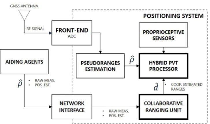
Figure 1:High-level block scheme of a networked positioning system including a collaborative ranging module.
measurements of proximity such as the ones obtained from exteroceptive sensors, does not allow an effective exploitation of spatial diversity of the vehicles. There-fore, an extension of the communication availability can be provided through ad hoc DSRC or cellular network. Direct Short Range Communication (DSRC) has been deeply investigated to support collaborative positioning for the exchange of GNSS data. In this case, the com-munication is provided throughout WLAN connectivity and is limited to operational range of the physical layers foreseen by 802.11 standards. Despite this limitation the communication latency is typically contained, thus guaranteeing adequate time-consistency among the ex-changed data. Vehicles communicating through DSRC are likely to be in Line-of-Sight, thus high-quality rela-tive positioning information (i.e. inter-vehicle distances) can be easily obtained through the aforementioned exte-roceptive sensors. Several protocols integrate messages for cooperative navigation of the vehicles but until to-day, the improvement of the absolute positioning has not been yet addressed in the standards. Differently, according to the paradigm of the C-V2X, the commu-nication provided through the cellular network involves other nodes of the network infrastructure, thus increas-ing the operational latency. However, the communication based on the cellular network can easily overcome the physical constraint of NLOS scenarios. By relying on the presented paradigms, a further distinction has to be considered also about the usage of the exchanged infor-mation. The data can be processed in a centralized or quasi-centralized fashion in which the data from groups of cooperating vehicles is processed at a central node and then re-distributed to the members [10, 14]. Alter-natively, data can be spread and processed at each node in a distributed fashion whereby each vehicle utilizes the generated range constraints independently [1, 16, 17].
Distributed cooperative positioning based on the inte-gration of hybrid navigation data has been investigated in the field of robotics and an extension to Intelligent Transportation Systems (ITS) is appealing in the rise of smart cities. Regardless of the approach selected or the technologies used to achieve it, the inclusion of coop-erative positioning should result in the triple benefit of improving absolute positioning accuracy, improving rela-tive positioning accuracy, while also providing improved situational awareness of the other vehicles operating in proximity to each other, making the task of navigating in an urban environment both more accurate and safer for all cooperating users.
2.1
GNSS-based cooperative navigation
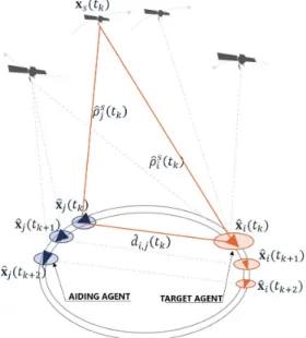
2.1.1 GNSS-based cooperative ranging methods. Accord-ing to what described so far, the computation of inter-vehicular ranges is of prominent importance for cooper-ative positioning of swarms of vehicles, since it can be used as an auxiliary information to mutually improve localization performance. To this aim, a set of techniques [3] [18] have been studied in the field to determine the distance between cooperating agents by exchanging their GNSS raw measurements and navigation data. These GNSS-based methods allow to extract a terrestrial col-laborative range measurement whenever the agents share the LOS visibility of a number of common satellites [18], as described in Figure 2. These techniques are based on the evaluation of the modulus of a three-dimensional displacement vector between pairs of cooperating agents. Given that Euclidean distance between the standalone GNSS estimations cannot provide additional informa-tion on the estimainforma-tions themselves, the most relevant algorithms require three or more equation thus, three or more shared satellites. This condition cannot always be satisfied in dense urban scenarios and a less demanding collaborative strategy has also been proposed by the authors to overcome the limited availability of shareable satellites [11] [12].
2.1.2 Cooperative positioning based on collaborative range measurements.When inter-vehicular ranges are integrated in hybrid localization algorithms, the quality of such ad-ditional measurements directly affects the quality of the positioning information. Effective implementation of GNSS-based cooperative navigation supported by DSRC showed a remarkable performance improvements w.r.t. non-cooperative positioning solutions [8]. The au-thors showed that cooperative positioning can benefits from the integration of DD-based inter-vehicles ranges thus guaranteeing remarkable improvements in different environments. Similarly, performance improvement in
Figure 2:Two communicating agents are able to extract an inter-vehicular range from their GNSS observables.
terms of continuity have been shown in [13] by exploit-ing an Inter-Agent Range tight integration based on a hybridized Extended Kalman Filter (EKF).
3
METHODOLOGY
In this section we describe a methodology for the coop-erative navigation of connected vehicles, when they rely just on GNSS observables. A general algorithm for the collaborative extraction of GNSS-based inter-vehicular ranges among networked vehicles is recalled, along with benefits and limitations of this implementation, enabling the successive integration of these auxiliary measure-ments in the positioning algorithm.
3.1
GNSS positioning basics
A positioning system based on GNSS achieves the po-sition estimation ^x𝑖 (︀ 𝑡𝑘 )︀ = [︀ ^ 𝑥𝑖 (︀ 𝑡𝑘 )︀ ^ 𝑦𝑖 (︀ 𝑡𝑘 )︀ ^ 𝑧𝑖 (︀ 𝑡𝑘 )︀]︀ for the user 𝑖 by means of a trilateration operation on a sufficient number of ranges between the user and the satellites [7]. The structure of a GNSS signal and the signal processing architecture of the receiver allow to extract this range information along with a spatial offset 𝑏𝑖 due to the presence of a user clock bias. This estimate
is calledpseudorange and is commonly defined by: ^ 𝜌𝑠𝑖(︀ 𝑡𝑘)︀ =||x^𝑖(︀𝑡𝑘 )︀ −x^𝑠(︀𝑡𝑘 )︀ ||+^𝑏𝑖(︀𝑡𝑘 )︀ . (1)
Each pseudorange is a measure of the distance between the positions of a satellite 𝑠 and a user 𝑖 used along with the estimated satellite position ^x𝑠 to determine an
TOP-Cars’19 ’19, July 2, 2019, Catania, Italy A. Minetto, A. Nardin, F.Dovis
Once the satellites positions are known with a proper uncertainty, a set composed by at least four equations in the form of (1) provides a solution for the four scalar unknowns related to position of the user𝑖(^x𝑖 and ^𝑏𝑖).
Furthermore, the measurements of the doppler shift w.r.t. the known carrier frequency of the received signals can be used to determine the speed of the receiver. In a GNSS receiver the whole process, commonly referred to as Position, Time and Velocity (PVT) estimation, is performed through methods which exploit lineariza-tion of the satellite-to-user range informalineariza-tion such as least square routines and EKF, or alternatively by using Particle Filters (PF), according to the dynamics of the application [7]. Eventually, in order to obtain an esti-mate of x𝑖, a measurement collection ^𝜌𝑖 containing a
set of pseudoranges𝜌𝑠𝑖 is needed, along with the set of positions of the respective anchor points (the satellites) toward which the ranges are defined.
3.2
GNSS-based cooperative positioning
A communication infrastructure among vehicles allows to enrich the set of available range measurements, by merging terrestrial and satellite ones. In this cooperative framework, the additional ranges are an estimate ^𝑑𝑖𝑗 ofthe distance𝑑𝑖𝑗 between the user𝑖and an aiding agent
𝑗 included in the swarm of cooperative vehicles: ^
𝑑𝑖𝑗(︀𝑡𝑘)︀=||x^𝑖(︀𝑡𝑘)︀−x^𝑗(︀𝑡𝑘)︀||. (2)
A set ^d𝑖 of auxiliary cooperative ranges ^𝑑𝑖𝑗 is merged
with the set of pseudoranges building a hybrid measure-ment setz𝑖, such that
z𝑖(︀𝑡𝑘)︀= [︁ ^ 𝜌𝑖(︀𝑡𝑘)︀|d^𝑖(︀𝑡𝑘)︀ ]︁ . (3)
The enhanced observables set is then integrated in an hybrid PVT solution, which merges GNSS observables and cooperatively-obtained information to extract an enhanced position estimation, as described by Figure 1.
Being an extension of the legacy PVT operation, the hybrid PVT block integrates range measurements of dif-ferent nature and, as a consequence, it is adapted to reflect the ranging equations that relate those measure-ments to the position unknowns, such as (2) for what concerns cooperative ranges and (1) for pseudoranges [13]. Nevertheless, the auxiliary ranges obtained through cooperation must be then associated with the positions of the anchors, as done for the pseudoranges. A conver-gent hybrid PVT solution requires therefore an estimate of the aiding agent’s position for each aiding vehicle𝑗, in addition to satellites positions. This aspect of the cooperative paradigm discloses a privacy issue, which
could be mitigated exploiting pseudonymization or even neutralized through a virtual landmark approach [11].
3.2.1 Cooperative ranging algorithm.The collaborative paradigm discussed in this paper requires just GNSS hardware in addition to the network connectivity, thus only GNSS observables (pseudoranges) are exchanged on the communication link, along with the information about the location of the anchors. As mentioned in sec-tion 2.1.1 there are several GNSS-based cooperative ranging methods, which differ mainly in the number of GNSS observables required to obtain a single inter-vehicular range [18]. However, their range estimation procedures can be described by a generalized algorithm, here presented assuming a generalized Vehicle-to-Vehicle (V2V) communication.
Algorithm 1Cooperative range extraction.
1: 𝑖computes the pseudoranges from the set of visible satellites𝒮𝑖
2: 𝑖sends an help request including the unique identi-fiers (PRNs) of its visible satellites set𝒮𝑖
3: 𝑗 replies with: the set of necessary pseudoranges measurements 𝜌𝑠𝑗 with 𝑠 ∈ {𝒮𝑖∩ 𝒮𝑗}; its position
estimate ^x𝑗;
4: 𝑖computes the inter-vehicular range exploiting the collected pseudoranges.
Recalling the relevance of a precise clock for GNSS positioning, even in presence of high-quality oscillators it should be highlighted that the PVT solutions of collabo-rating receivers are not synchronous. This means that the shared measurements might not be consistent between the two agents, leading to a wrong inter-vehicular range estimation [13]. A correction must be applied in order to ensure consistency, provided that a timing informa-tion is associated to each measurement [4]. Nevertheless, communication latency must be also taken into account and an estimate of the network Round Trip Time (RTT) should be considered as well when performing the cor-rection. Therefore, besides the pseudoranges measured by the collaborative agents𝑗 and its position estimate ^
x𝑗, each shared measurement must be received with a
timestamp.
Moreover, some hybrid PVT algorithms may require a statistical model of cooperative ranges to optimize the integration [13]. In this case a statistical informa-tion associated to shared pseudoranges is required in the reply of the aiding agents in order to let the user 𝑖 build those models. When the user 𝑖 completes the procedure described in Algorithm 1, an auxiliary range is added to the measurement set (3). The hybrid PVT
routine is then performed to obtain an estimate of x𝑖.
This procedure can be easily adapted to a centralized paradigm, provided that the additional latency caused by a potential multi-hop communication will produce a negligible effect on measurement’s consistency. Although increasing the delay, a centralized approach would fa-vor the selectivity of cooperative data. The user𝑖 could therefore receive a selected set of pseudoranges from a subset of potential aiding agents, arranged in order to optimize its hybrid positioning performance in terms of accuracy and precision [13]. In fact, since for GNSS-based cooperative methods no LOS is required, a great number of cooperative candidates may be available for a connected swarm of vehicles, allowing a great selective capability.
4
RESULTS
This section shows a set of new results about the im-proved positioning accuracy of a given target vehicle ob-tained by tightly integrating collaborative inter-vehicular ranges w.r.t. a set of aiding vehicles. All the measure-ments involved are obtained through a fully GNSS soft-ware receiver processing digitalized realistic GNSS sig-nals generated in turn by an IFEN NavX simulator and acquired by Universal Software Radio Peripherals (USRP) N210. The sample application includes a set of aiding agents moving in the two directions of a circular trajectory of 200 m of radius, according to the simple scheme in Figure 2. During a timespan of 3600 s the agents perform several laps according to their different starting location thus considering a high dynamics of their relative distances. Furthermore, the tangent speed of each vehicle spans from 0 to 30 m/s within the first lap while it is kept constant in the following ones. A set of inter-vehicle ranges are computed w.r.t. five available aiding agents providing their time-stamped pseudorange measurements w.r.t. a reduced set of GPS satellites (i.e. PRN7, PRN3, PRN12, PRN11) as well as their estimated location.
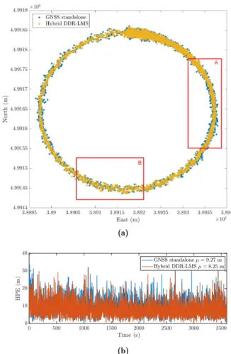
In Figure 3, an example of inter-vehicle distance is re-ported about target agent and a randomly chosen aiding vehicle. Each additional range is obtained by means of double differentiation of pseudorange measurements [8]. Thanks to the aforementioned compensation of time mis-alignment between measurements, the estimation error is kept with a 3-𝜎 value of about 5 meters. The inter-vehicle ranges are integrated in a Least Mean Square (LMS) solution according to the procedure described in Section 3. Figure 4a compares the horizontal positioning solutions for a GNSS standalone PVT and for the collab-orative approach, according to a North-East reference
Figure 3: Experimental range measurement and related range error obtained through double differencing.
frame. RegionsA andBidentify two examples in which remarkable benefits are provided by integrating double difference ranging and in which no relevant advantages are introduced through the technique, respectively.
(a)
(b)
Figure 4: Example of cooperative range integration. Esti-mated position for non cooperative and cooperative PVT solu-tions (4a) and absolute Horizontal Position Error (HPE) (4b).
TOP-Cars’19 ’19, July 2, 2019, Catania, Italy A. Minetto, A. Nardin, F.Dovis
Figure 4b shows the behavior of the absolute Horizon-tal Position Error (HPE) over the whole timespan of the experiment. In spite of a remarkable bias for both the solutions, one can notice that the time-averaged accuracy of the Hybrid LMS based on Double Difference Ranging (DDR) outperforms the standalone GNSS solution. The mean errors are indeed 8.25 m and 9.27 m respectively.
5
CONCLUSIONS
This work provides an overview about GNSS absolute positioning and navigation in urban context by target-ing the benefits of GNSS-only cooperative positiontarget-ing. This approach, inspired by previous works in the field of the robotics, can be enabled by modern communication networks, especially in urban areas. The paper presents new results about a LMS-based tight integration of col-laboratively generated inter-agent range measurements by means of double differentiation. The experimental results about a multi-agent environment along a circu-lar trajectory showed an average improvement of the accuracy of 1.02 m, thus an improvement of the position accuracy of about 11% w.r.t. the estimation error of a standalone GNSS PVT. Further works will extend the presented approach to advanced positioning algorithms (i.e. EKF, particle filter) as well as face the redistribution of collaborative positioning solution within the agents network.
REFERENCES
[1] M. A. Caceres, F. Penna, H. Wymeersch, and R. Garello. 2011. Hybrid Cooperative Positioning Based on Distributed
Belief Propagation.IEEE Journal on Selected Areas in
Com-munications 29, 10 (December 2011), 1948–1958. https:
//doi.org/10.1109/JSAC.2011.111205
[2] F. De Ponte Müller. 2017. Survey on Ranging Sensors and Cooperative Techniques for Relative Positioning of Vehicles.
Sensors17, 2 (2017). https://doi.org/10.3390/s17020271
[3] F. de Ponte Müller, E. M. Diaz, B. Kloiber, and T. Strang. 2014. Bayesian cooperative relative vehicle positioning using
pseudorange differences. In 2014 IEEE/ION Position,
Lo-cation and Navigation Symposium - PLANS 2014. 434–444.
https://doi.org/10.1109/PLANS.2014.6851401
[4] F. De Ponte Müller, A. Steingass, and T. Strang. 2013. Zero-Baseline Measurements for Relative Positioning in Vehicular
Environments. In6th European Workshop on GNSS Signals
and Signal Processing. https://elib.dlr.de/86457/
[5] F. Dovis, C. Chiasserini, L. Musumeci, and C. Borgiattino. 2014. Context-aware peer-to-peer and cooperative positioning. InInternational Conference on Localization and GNSS 2014 (ICL-GNSS 2014). 1–6. https://doi.org/10.1109/ICL-GNSS.
2014.6934166
[6] D. A. Grejner-Brzezinska, C. K. Toth, T. Moore, J. F. Raquet, M. M. Miller, and A. Kealy. 2016. Multisensor Navigation
Systems: A Remedy for GNSS Vulnerabilities? Proc. IEEE
104, 6 (June 2016), 1339–1353. https://doi.org/10.1109/
JPROC.2016.2528538
[7] E. D. Kaplan and C. Hegarty. 2017. Understanding
GPS/GNSS: Principles and applications. Artech House.
[8] K. Liu, H. B. Lim, E. Frazzoli, H. Ji, and V. C. S. Lee. 2014. Improving Positioning Accuracy Using GPS Pseudorange
Measurements for Cooperative Vehicular Localization.IEEE
Transactions on Vehicular Technology63, 6 (July 2014), 2544–
2556. https://doi.org/10.1109/TVT.2013.2296071
[9] A. Martinelli, F. Pont, and R. Siegwart. 2005. Multi-Robot
Localization Using Relative Observations. InProceedings of
the 2005 IEEE International Conference on Robotics and Automation. 2797–2802. https://doi.org/10.1109/ROBOT.
2005.1570537
[10] C. Mensing and J. J. Nielsen. 2010. Centralized coopera-tive positioning and tracking with realistic communications
constraints. In2010 7th Workshop on Positioning,
Naviga-tion and CommunicaNaviga-tion. 215–223. https://doi.org/10.1109/
WPNC.2010.5651897
[11] A. Minetto, C. Cristodaro, and F. Dovis. 2017. A collabora-tive method for positioning based on GNSS inter agent range
estimation. In2017 25th European Signal Processing
Con-ference (EUSIPCO). 2714–2718. https://doi.org/10.23919/
EUSIPCO.2017.8081704
[12] A. Minetto and F. Dovis. 2018. A theoretical framework for collaborative estimation of distances among GNSS users. In
2018 IEEE/ION Position, Location and Navigation Sympo-sium (PLANS). 1492–1501. https://doi.org/10.1109/PLANS.
2018.8373543
[13] A. Minetto, A. Nardin, and F. Dovis. 2018. Tight Integration of GNSS Measurements and GNSS-based Collaborative
Vir-tual Ranging. In31st International Technical Meeting of the
Satellite Division of The Institute of Navigation (ION GNSS+ 2018). 2399–2413. https://doi.org/10.33012/2018.15955
[14] E. D. Nerurkar and S. I. Roumeliotis. 2010.
Asynchro-nous Multi-Centralized Cooperative Localization. In2010
IEEE/RSJ International Conference on Intelligent Robots and Systems. 4352–4359. https://doi.org/10.1109/IROS.2010.
5650133
[15] P. Papadimitratos, A. D. La Fortelle, K. Evenssen, R. Brignolo, and S. Cosenza. 2009. Vehicular communication systems: Enabling technologies, applications, and future outlook on
intelligent transportation.IEEE Communications Magazine
47, 11 (November 2009), 84–95. https://doi.org/10.1109/ MCOM.2009.5307471
[16] M. Rohani, D. Gingras, V. Vigneron, and D. Gruyer. 2015. A New Decentralized Bayesian Approach for Cooperative Vehicle Localization Based on Fusion of GPS and VANET
Based Inter-Vehicle Distance Measurement.IEEE Intelligent
Transportation Systems Magazine7, 2 (Summer 2015), 85–95.
https://doi.org/10.1109/MITS.2015.2408171
[17] S. I. Roumeliotis and G. A. Bekey. 2000. Collective lo-calization: a distributed Kalman filter approach to
local-ization of groups of mobile robots. In Proceedings 2000
ICRA. Millennium Conference. IEEE International Con-ference on Robotics and Automation. Symposia Proceed-ings (Cat. No.00CH37065), Vol. 3. 2958–2965 vol.3. https:
//doi.org/10.1109/ROBOT.2000.846477
[18] M. Tahir, S. S. Afzal, M. S. Chughtai, and K. Ali. 2019. On the Accuracy of Inter-Vehicular Range Measurements
Using GNSS Observables in a Cooperative Framework.IEEE
Transactions on Intelligent Transportation Systems20, 2 (Feb