PLYMOUTH COMPREHENSIVE PLAN
Chapter 1
Introduction
Chapter 2
Community Background
Chapter 3
Land Use
Chapter 4
Housing
Chapter 5
Surface Water
Chapter 6
Transportation
Chapter 8
Water Supply
Chapter 7
Parks,Trails & Open Space
Chapter 10
Public Facilities
Chapter 9
CHAPTER 1
Introduction
Adopted
Chapter 1
INTRODUCTION
A
AUTHORITY AND PROCESS
The City of Plymouth has prepared this update of its Comprehensive Plan to guide community development and improvements over the next 20 years. State law authorizes a municipality to prepare a comprehensive plan. State law also requires that a municipality within the seven-county metropolitan area review, and if necessary revise, its comprehensive plan every ten years.
State law requires that a municipality undertake a public process to gain citizen input as part of the preparation of a comprehensive plan. The City of Plymouth undertook an extensive public process as part of this plan update. The process began in the summer of 2005 with the determination that the City would initially focus on the largely undeveloped northwest area. Input gathered through numerous workshops and open houses during the following year helped shape the land use plan for Northwest Plymouth.
At the beginning of 2007, the City shifted focus to the existing urbanized area of the city and to each of the functional plans for housing, parks, streets and utilities. Over the following nine-month period, the City held additional workshops and public meetings to discuss and obtain feedback on these individual plans.
The overall Comprehensive Plan replaces the last major plan update, which the City adopted in August 2000, and all amendments to that plan. Since 2000, Plymouth has moved closer to becoming a fully developed community with an increasingly limited supply of undeveloped land and an emerging need for redevelopment.
The Comprehensive Plan is contained in two books. Book 1 contains the body of the plan. Book 2 includes all appendices. Book 1 begins with community background information and the vision statements that guided all elements of the plan. Chapters
on land use, housing, surface water management, transportation, parks, trails recreation and open space, water supply and distribution, sanitary sewer and public facilities follow. Each of these chapters includes goals and policies, plans that reflect the policy direction, and an implementation plan. Book 2 contains technical
appendices for most of the chapters.
B
IMPLEMENTATION
The purpose of addressing implementation in the Comprehensive Plan is to set forth the actions that the City will take to ensure that the plans, programs and policies set forth in the plan will be carried out by the decisions that the City makes on a daily basis. The implementation section in each chapter provides guidance to policy-makers and staff for the timing and priority of a wide range of strategies
recommended to carry out the plan. Some implementation strategies are on-going City activities that will be continued and others are new initiatives.
Implementation activities fall into the following general categories:
Future studies and planning activities – additional planning or research that must occur before a specific course of action may be recommended. For example, completing a fire services study would precede any planning for a fourth fire station.
Ordinance/ City Code amendments – amendments to the “official controls,” including the zoning and subdivision regulations, that the City uses to regulate land use and establish standards for development. Amendments to official controls may include amendments to the text of the Zoning Ordinance that affect the city as a whole, or may affect specific areas of the community; for example, a zoning map amendment to ensure consistency with the land use guide plan.
Intergovernmental cooperation – working with another community or agency to address mutual needs or issues. Examples of intergovernmental cooperation would include sharing park facilities with a school district, or connecting to a sewer line in an adjacent community.
Capital improvements – financing and building the physical facilities (roads, buildings, utilities, etc.) needed to meet the needs of new development and to maintain the City’s infrastructure. The City updates its five-year capital
improvement program (CIP) on an annual basis. The CIP is part of this plan. Only projects expected to be needed in the next five years are included in the CIP.
Other strategies – actions to be carried out through other policies, programs or
initiatives of the City. These strategies may include policy directives or statements of positions that will be taken when the City is confronted with a particular issue or request.
The general time frame within which the City intends to carry out each activity is indicated for each implementation strategy. Some strategies represent programs or activities already in place that the City plans to continue – those are listed as
“ongoing.” The timing and priority of the strategies will regularly be reevaluated as part of the City Council’s priority-setting and work planning process. For capital improvements, project timing is based on when the project will be included in the City’s CIP. The City re-evaluates the timing, cost and funding source for each project and updates the CIP every year. Timing is indicated as follows:
Implementation Strategy Timing:
Ongoing Continuous or existing effort
Short 1 to 5 years; included in 5-year Capital Improvements Program (CIP) Medium 5 to 10 years, or needed to serve the City’s 2030 urban area
Long May not be needed until next time the City updates its plan The implementation plan is not intended to be all-inclusive of the planning and policy efforts that the City will undertake to fulfill the goals of the Comprehensive Plan. It is intended to identify the major initiatives and those that represent significant new direction or require significant efforts by the Council, staff and the City’s advisory boards and commissions. The City is constantly reviewing its operations (such as services, facilities and personnel requirements) for improvements to meet the changing needs of the City. These types of efforts are not included in the implementation sections of the individual chapters.
The entire Comprehensive Plan will be re-evaluated, at a minimum, every ten years as required by law. The implementation activities identified as “long term” will be re-evaluated at such time as the City undertakes its next Comprehensive Plan update.
C
ACKNOWLEDGEMENTS
The City acknowledges the work of the following individuals in the preparation of this comprehensive plan:
Plymouth City Council
Kelli Slavik, Mayor
Judy Johnson, Ward 1* Kathleen Murdock, Ward 2
Bob Stein, Ward 3 Ginny Black, Ward 4
Jim Willis, At-Large *Sandy Hewitt until January 1, 2009
Tim Bildsoe, At-Large
Plymouth Planning Commission*
James Holmes, Chair, Ward 3
Jim Davis, Ward 1 Terri Jaffoni, Ward 2
Frank Weir, Ward 4 Karl Neset, At-Large
Erik Aamoth, At-Large John Cooney, At-Large
Plymouth Parks and Recreation Advisory Commission*
Ronald Fiemann, Chair, Ward 2
Greg Anderson, Ward 1 Ellie Singer, Ward 3
Richard Krahulec, Ward 4 Patrick Knight, At-Large
Seth Pederson, At-Large Michael Smith, At-Large
Plymouth Advisory Committee on Transit (PACT)*
Terry Cheng, Chair
Patricia Doten Mary Paprocki Carmen Pehler Vivian Honer Sylvia Gustafson Terry Bliss
Environmental Quality Committee*
Kathleen Osborne, Chair, Ward 1
Carlos Gutierrez, Ward 2 Terrie Christian, Ward 3
Sally Strand, Ward 4 John Berrigan, Jr., At-Large
David Pellinger, At-Large Laura Brinkman, At-Large
City Staff
Laurie Ahrens, City Manager
Steve Juetten, Community Development Director Doran Cote , Public Works Director
Eric Blank, Parks and Recreation Director Mike Goldstein, Police Chief
Barbara Senness, Land Use Convener Rick Kline, Fire Chief
Jim Barnes, Housing Convener Bob Moberg, Transportation Convener
Josh Doty, Public Facilities Convener Shawn Drill, Water/Sewer Convener
Derek Asche, Surface Water Convener Diane Evans, Parks Convener
Helen LaFave, Communications Manager
Consultants
Resource Strategies Corp. SEH, Inc.
SRF Consulting Group, Inc. * City Council and Commission Members as of January 1, 2007
PLYMOUTH COMPREHENSIVE PLAN
Chapter 1
Introduction
Chapter 2
Community Background
Chapter 3
Land Use
Chapter 4
Housing
Chapter 5
Surface Water
Chapter 6
Transportation
Chapter 8
Water Supply
Chapter 7
Parks,Trails & Open Space
Chapter 10
Public Facilities
Chapter 9
CHAPTER 2
Community Background
Adopted
TABLE OF CONTENTS
A CHAPTER PURPOSE ... 1
B PLANNING AREA DESIGNATION ... 1
C GROWTH FORECASTS AND TRENDS ... 1
D PHYSICAL SETTING ... 2
E VISION STATEMENTS ... 6
LIST OF TABLES
2-1 Household, Population and Employment Forecasts ... 22-2 Population Characteristics ... 2
2-3 2006 Existing Land Use ... 5
FIGURE
2-1 Existing Land Use ... 3Chapter 2
Community Background
A
CHAPTER PURPOSE
The Community Background chapter sets the stage for the rest of the City’s
Comprehensive Plan. It: 1) identifies the City’s planning area designation within the larger region; 2) includes growth forecasts and major trends; 3) provides an overview of the physical setting; and 4) presents the City’s vision statements.
B
PLANNING AREA DESIGNATION
The Metropolitan Council classifies Plymouth as a “developing” community, based on the amount of undeveloped land in Northwest Plymouth. However, the City is approaching a developed status, which is defined as a community with more than 85 percent of the land area developed. As Plymouth approaches full development, the City will increasingly face issues of maintenance and redevelopment rather than those associated with new development.
C
GROWTH FORECASTS AND TRENDS
The anticipated change in population, households and employment affects all parts of the Comprehensive Plan. For example, the number of households and workers in the city drives the need for services and infrastructure. The number of anticipated new households relates to the need for new housing and additional parks, open space and other City services. Table 2-1 summarizes the City’s 2030 forecasts.
TABLE 2-1
HOUSEHOLD, POPULATION AND EMPLOYMENT FORECASTS
2006 Estimate 2030 Forecast Percent Change
Households 27,771 33,500 +20%
Population 70,676 78,500 +11%
Employment 51,043 64,500 +26%
Source: Metropolitan Council
Plymouth’s population is anticipated to increase 11 percent between 2006 and 2030. During this same period, the region’s population is expected to increase nearly 28 percent.
Although population growth is expected to slow, the city can still expect to see substantial household and employment growth in coming years. However, Table 2-2 indicates that the make-up of the population will be different than in decades past. In the future, the city can expect that the population will be older and more diverse. This will affect the type of housing and services that residents’ demand.
TABLE 2-2
POPULATION CHARACTERISTICS
1990 Percent of Total Population 2000 Percent of Total Population Population 60+ years 3,721 7.3% 7,331 11.1% Median age (in years) 31.9 36.1Non-white population 2,259 4.4% 5,694 9.1%
Source: U.S. Census
D
PHYSICAL SETTING
Plymouth is largely developed except for the northwest corner of the city that until now has remained outside the metropolitan urban service area. The City expects to see the most change in the northwest area between now and 2030. Existing land use as of January 2006 is illustrated in Table 2-3 and Figure 2-1.
1 7 2 0 0 I N L A N D 1 7 1 0 0 H O L L Y 1 7 0 0 0 G A R L A N D 1 7 3 0 0 J E W E L 1 7 4 0 0 K IM B E R L Y 1 9 1 0 0 B R O C K T O N 1 7 5 0 0 L A W N D A L E 1 7 6 0 0 M E R R IM A C 1 7 7 0 0 N A R C IS S U S 1 7 8 0 0 O L IV E 1 7 9 0 0 P E O N Y 1 8 0 0 0 Q U E E N S L A N D 1 8 1 0 0 R A N IE R 1 8 2 0 0 S H A D Y V IE W 1 8 3 0 0 T R O Y 1 8 4 0 0 U R B A N D A L E 1 8 5 0 0 V A G A B O N D 1 8 7 0 0 X A N T H U S 1 8 6 0 0 W A L N U T G R O V E 1 8 8 0 0 Y E L L O W S T O N E 1 8 9 0 0 Z IR C O N 1 9 0 0 0 A L V A R A D O 1 4 9 0 0 L A N E W O O D 1 4 8 0 0 K IN G S V IE W 1 5 0 0 0 M IN N E S O T A 1 5 1 0 0 N IA G A R A 1 5 3 0 0 P O L A R IS 1 5 2 0 0 O R C H ID 1 5 4 0 0 Q U A N T IC O 1 5 5 0 0 R A N C H V IE W 1 5 6 0 0 S H E N A N D O A H 1 5 7 0 0 T E R R A C E V IE W 1 5 8 0 0 U P L A N D 1 6 0 0 0 W E S T O N 1 5 9 0 0 V IC K S B U R G 1 6 2 0 0 Y U M A 1 6 1 0 0 X E N E 1 6 4 0 0 A R C H E R 1 6 3 0 0 Z A N Z IB A R 1 6 5 0 0 B L A C K O A K S 1 6 6 0 0 C O M S T O C K 1 6 8 0 0 E V E R E S T 1 6 9 0 0 F O U N T A IN 1 6 7 0 0 D U N K IR K 1 2 6 0 0 O A K V IE W 1 2 8 0 0 Q U IN W O O D 1 3 0 0 0 S Y C A M O R E 1 2 9 0 0 R O S E W O O D 1 3 3 0 0 V IN E W O O D 1 3 2 0 0 U N D E R W O O D 1 3 4 0 0 W E D G E W O O D 1 3 1 0 0 T E A K W O O D 1 2 7 0 0 P IN E V IE W 1 3 7 0 0 Z IN N IA 1 3 6 0 0 Y U C C A 1 3 8 0 0 A N N A P O L IS 1 3 5 0 0 X E N IU M 1 3 9 0 0 B E R K S H IR E 1 4 0 0 0 C H E S H IR E 1 4 1 0 0 D A L L A S 1 4 2 0 0 E M P IR E 1 4 3 0 0 F E R N B R O O K 1 4 4 0 0 G L A C IE R 1 4 5 0 0 H A R B O R 1 4 7 0 0 J U N E A U 1 4 6 0 0 I T H A C A 5TH AVE. 10TH AVE. RIDGEMOUNT AVE. 15TH AVE. 20TH AVE. 25TH AVE. 30TH AVE. 35TH AVE. 40TH AVE. 45TH AVE. 50TH AVE. 55TH AVE. 1 0 3 0 0 R E V E R E 1 0 4 0 0 S A R A T O G A 1 0 6 0 0 U N IO N T E R R A C E 1 0 5 0 0 T R E N T O N 1 0 8 0 0 W E L L IN G T O N 1 0 7 0 0 V A L L E Y F O R G E 1 0 9 0 0 X IM IN E S 11 0 0 0 Y O R K T O W N 11 1 0 0 Z A C H A R Y 11 2 0 0 A R R O W O O D 11 3 0 0 B A L S A M 11 4 0 0 C O T T O N W O O D 11 6 0 0 E V E R G R E E N 11 5 0 0 D E E R W O O D 11 8 0 0 G O L D E N R O D 11 7 0 0 F O R E S T V IE W 1 2 0 0 0 I V E S 11 9 0 0 H E M L O C K 1 2 2 0 0 K IR K W O O D 1 2 1 0 0 J O N Q U IL 1 2 3 0 0 L A R C H 1 2 4 0 0 M A G N O L IA 1 2 5 0 0 N O R W O O D 9 6 0 0 K IL M E R 9 5 0 0 T .H . 1 6 9 9 7 0 0 L A N C A S T E R 9 8 0 0 M O N T IC E L L O 9 9 0 0 N A T H A N 1 0 0 0 0 O R L E A N S 1 0 2 0 0 Q U A K E R 1 0 1 0 0 P IL G R IM 60TH AVE. 1 4 0 0 0 C H E S 1 7 5 0 0 L A W N 1 9 0 0 0 A L V A R 1 8 8 0 0 Y E L L O 1 8 6 0 0 W A L N 1 8 5 0 0 V A G A 1 8 4 0 0 U R B A 1 8 2 0 0 S H A D 1 8 0 0 0 Q U E E 1 7 7 0 0 N A R C 1 7 6 0 0 M E R R 1 9 1 0 0 B R O C 1 8 9 0 0 Z IR C O 1 8 7 0 0 X A N T 1 7 9 0 0 P E O N 1 8 3 0 0 T R O Y 1 8 1 0 0 R A N IE 1 7 8 0 0 O L IV E 1 5 7 0 0 T E R R 1 6 6 0 0 C O M S 1 6 5 0 0 B L A C 1 5 9 0 0 V IC K 1 7 4 0 0 K IM B 1 7 0 0 0 G A R L 1 7 3 0 0 J E W E 1 7 1 0 0 H O L L 1 7 2 0 0 IN L A N 1 6 7 0 0 D U N K 1 6 9 0 0 F O U N 1 6 8 0 0 E V E R 1 6 3 0 0 Z A N Z 1 6 4 0 0 A R C H 1 6 2 0 0 Y U M A 1 6 1 0 0 X E N E 1 6 0 0 0 W E S T 1 5 8 0 0 U P L A 1 4 3 0 0 F E R N 1 5 6 0 0 S H E N 1 5 5 0 0 R A N C 1 5 4 0 0 Q U A N 1 5 0 0 0 M IN N 1 4 8 0 0 K IN G 1 4 9 0 0 L A N E 1 5 3 0 0 P O L A 1 5 2 0 0 O R C H 1 5 1 0 0 N IA G 1 4 4 0 0 G L A C 1 4 6 0 0 IT H A 1 4 7 0 0 J U N E 1 4 5 0 0 H A R B 1 4 2 0 0 E M P 1 4 1 0 0 D A L L 1 2 2 0 0 K IR K 1 2 5 0 0 N O R 1 2 4 0 0 M A G 1 3 9 0 0 B E R K 1 3 8 0 0 A N N A 1 3 1 0 0 T E A K 1 3 4 0 0 W E D 1 3 2 0 0 U N D 1 3 3 0 0 V IN E 1 2 9 0 0 R O S 1 3 0 0 0 S Y C A 1 2 8 0 0 Q U IN 1 3 5 0 0 X E N IU 1 3 6 0 0 Y U C C 1 3 7 0 0 Z IN N 1 2 7 0 0 P IN E 1 2 3 0 0 L A R C 1 2 6 0 0 O A K 11 7 0 0 F O R 11 8 0 0 G O L 11 5 0 0 D E E 11 6 0 0 E V E R 11 4 0 0 C O T 11 2 0 0 A R R 11 0 0 0 Y O R 1 0 7 0 0 V A L L 1 0 8 0 0 W E L 1 0 6 0 0 U N IO 11 3 0 0 B A L S 1 2 1 0 0 J O N Q 11 9 0 0 H E M 1 2 0 0 0 IV E S 1 0 9 0 0 X IM IN 11 1 0 0 Z A C H 1 0 5 0 0 T R E 9 8 0 0 M O N 9 7 0 0 L A N C 1 0 4 0 0 S A R 9 6 0 0 K IL M 1 0 0 0 0 O R L 1 0 1 0 0 P IL G 1 0 2 0 0 Q U A 1 0 3 0 0 R E V 9 9 0 0 N A T H 9 5 0 0 T .H . 1 RIDGEMOUNT AVE. 5TH AVE. 10TH AVE. 20TH AVE. 15TH AVE. 25TH AVE. 35TH AVE. 30TH AVE. 40TH AVE. 45TH AVE. 50TH AVE. 55TH AVE. 60TH AVE. V IC K S B U R G L A CO RD NO 6 IN T ER S TA T E HW Y N O 49 4 C O R D N O 1 0 1 INT ER ST AT E H WY NO . 49 4 CO R D N O 2 4 C O R D N O 1 0 1 IN TE R ST AT E HW Y N O 4 9 4 CO RD NO 6 CO RD NO 47 BASS LAKE RD BASS LAK E RD STAT E HW Y NO 55 STA TE H IGH W AY N O 55 S TA TE HW Y NO 55 STATE HW Y N O 55 S T A T E H W Y N O 1 6 9 S T A T E H W Y N O 1 6 9 STA TE H IGH W AY N O 55 S T A T E H W Y N O 1 6 9 S T A T E H W Y N O 1 6 9 ROCK FORD RD ROCKFORD RD S T A T E H W Y N O 1 6 9 CO RD NO 47 CO RD NO 47 CO R D 47 CO RD NO 4 7 BASS LAKE RD C O R D N O 1 0 1 CO RD NO 24 CO RD NO 6 CO RD NO 6 C O R D N O 1 0 1 STAT E HW Y N O 55 CO RD NO 15 Hidden Lake Medicine Lake Lost Lake Schmidt Lake Bass Lake Pike Lake Lake Camelot Pomerleau Lake Curtis Lake Turtle Lake Parkers Lake Cavanaugh Lake Gleason Lake Hadley Lake Mooney Lake Snyder Lake Kreatz Lake City of Medicine Lake
City of
FIGURE 2-1
Existing
Land Use
0 0.25 0.5 1 1.5 2 MilesTHIS REPRESENTS A COMPILATION OF INFORMATION AND DATA FROM CITY, COUNTY, STATE AND OTHER SOURCES THAT HAS NOT BEEN FIELD VERIFIED. INFORMATION SHOULD BE FIELD
VERIFIED AND COMPARED WITH ORINGIAL SOURCE DOCUMENTS.
K
Legend
City Limits Lakes
SINGLE FAMILY DEVELOPMENT TOWN HOME (2 or more attached units)
MULTIPLE FAMILY RESIDENTIAL (apartments & condos) COMMERCIAL INDUSTRIAL PUBLIC CHURCH SCHOOL PARKS/OPEN SPACE RAILROAD UTILITY VACANT
As of January 1, 2006
TABLE 2-2
2006 EXISTING LAND USE
Land Use Acres Units Percent of Total
Single Family 8447.17 15,997 46.7% Townhomes (2 or more attached units) 293.03 3,632 1.6% Multiple Family (apartments & condos) 852.48 10,197 4.7%
Commercial 1153.16 6.4%
Industrial 1520.88 8.4%
Public Land & Buildings 276.80 1.5%
Church 212.41 1.2% School 538.56 3.0% Parks/Open Space 3363.07 18.6% Railroads 108.87 0.6% Utility Property 23.50 0.1% Vacant 1277.22 7.1% Total 18067.15 29,286 100.0%
Source: City of Plymouth
During the drafting of this plan, the City of Plymouth contracted with Hennepin County to conduct land cover classification mapping and natural areas assessment for the entire city. The goal of this project was to classify all land into land cover types, assess the ecological quality of the remaining natural areas and recommend potential natural/open space corridors.
Within the developed portion of Plymouth, the “conceptual greenway corridors” identified in the inventory are by and large either under public ownership or are wetlands protected under the Wetland Conservation Act. The same holds true for portions of the corridor identified in Northwest Plymouth. The City will use the
Natural Resources Inventory to help guide development decisions affecting identified
corridors in this part of the city. Findings of the inventory were integral to developing several Comprehensive Plan chapters and will be valuable as future decisions are made.
E
VISION STATEMENTS
The community vision statements were first developed in a community forum held during the preparation of the City’s 2000 Comprehensive Plan. The vision
statements were updated in a City Council/Planning Commission workshop in 2005.
1
Maintain a safe and secure community.
Plymouth values the safe and secure environment currently found in the community. Safety and security are reflected in the low crime rate and superior police protection, quality fire protection and response time and the availability of health and
community services. Residents value the involvement of individuals, families and neighborhoods in creating a safe environment.
2
Protect and enhance the natural environment.
Plymouth values the natural resources in the community, including lakes, ponds, streams, wetlands and the rolling and wooded terrain and consequently, the preservation and maintenance of these resources. A healthy environment is
important to people, and the existing natural resources contribute to the livability of the community.
3
Support high quality education.
Plymouth values education, supports the public and private schools in the community and places an emphasis on educating the youth of the community. There is pride in the quality of school facilities, the safety of school buildings and grounds and the quality of school programs.
4
Maintain and enhance housing quality and diversity.
Plymouth values housing that is attractive, well constructed and maintained to ensure quality of life for all residents. Plymouth also values diverse housing opportunities in neighborhoods throughout the community, including affordable housing, renter and owner-occupied housing, senior housing and life-cycle housing.
5
Protect and enhance convenience and mobility.
Plymouth values the convenience and mobility provided by the community’s strategic geographic location in the metropolitan area. Three regional highways run through the community, providing direct access to the rest of the region. The layout of the community affords convenient access to goods and services within the community. The trail system and public transportation provide valuable alternative modes of transportation. The mix of housing and business within the community allows residents to live near their place of employment. Moving forward, investment in all modes of transportation is essential to realizing the City’s vision.6
Promote and strengthen economic vitality.
Plymouth values the strong economy and diverse tax base within the community, which includes high quality commercial and industrial development to complement the residential development. The diversity of development within the community results in a balanced tax base, maintenance of high property values and a wide variety of employment opportunities. Plymouth recognizes, however, that as the community ages, maintenance of its assets as well as redevelopment will be necessary
components of the community’s economic vitality. Therefore, Plymouth supports both maintenance programs (e.g. code enforcement) and redevelopment as tools to sustain economic health.
7
Provide high quality City services and facilities.
Plymouth values both the facilities and services the City provides. The park and trail systems as well as special programs such as those for seniors contribute to the quality of life within the community. Other City facilities and services, such as public safety, public works, recycling and long-term planning also contribute to a high quality of life. The many resident volunteers that supplement the work of City staff represent an important contribution for which the City is rightfully proud. The City is well-governed and well-managed, and both residents and businesses look forward to a continued high level of community-based services. The community will continue to be responsive to the emerging trends and changing needs of its residents and businesses.
8
Enhance and strengthen the sense of community.
Plymouth values its sense of community. People are connected to the community, want to continue to strengthen this sense of place, are involved in community life (government, religious institutions, schools, libraries, recreation, arts and volunteer efforts) and are able to bridge physical barriers to come together. There is a pride in the community that will be made stronger as the community matures.
CHAPTER 3
Land Use Plan
Adopted
TABLE OF CONTENTS
A CHAPTER PURPOSE ... 1 B GOALS AND POLICIES ... 1
C
DEVELOPMENT APPROACH ...
1 NORTHWEST PLYMOUTH ...
a Rural-to-Urban Land Use Classifications ...
b Northwest Plymouth Development Forecast and Density ...
c Northwest Plymouth Performance Standards ...
(1) Clustering and Custom Lot Grading ...
(2) Architectural Standards...
(3) Non-sequential Utility Staging and Assessment Deferrals ...
(4) Northwest Greenway Implementation ...
2 EXISTING URBAN AREA ...
a City Center……. ...
b Four Seasons Shopping Center ...
c Northwest Corner of Rockford Road and Highway 55 ...
d Southwest Corner of County Road 101 and Highway 55 ...
e Industrial Area Southeast of Medicine Lake ...
f Highway 55 Corridor ... 3 MIXED USE………... 4 HISTORIC PRESERVATION ... 5 SOLAR PROTECTION ... 4 4 7 7 8 8 9 9 9 10 10 11 12 12 12 13 13 13 14 D
LAND USE CLASSIFICATIONS ...
1 RESIDENTIAL LAND USES ...
2 COMMERCIAL LAND USES ...
3 INDUSTRIAL LAND USES ...
4 PUBLIC/SEMI-PUBLIC/INSTITUTIONAL LAND USES ...
5 MIXED USE ... 14 15 16 16 17 17 E 2030 CITYWIDE DEVELOPMENT ... 18 F CONSISTENCY WITH OFFICIAL CONTROLS ... 20
G IMPLEMENTATION ... 20
TABLE OF CONTENTS
continued
LIST OF TABLES
3-1 Northwest Plymouth Development Forecast/Density ... 8
3-2 Future Land Use ... 14
3-3 Land Use in 5-Year Stages ... 19
LIST OF FIGURES
3-1 2030 Land Use Plan ... 5
3-2 Northwest Greenway ... 9
3-3 City Center ... 11
LIST OF APPENDICES
3A PUBLIC PARTICIPATION PROCESS
3B ENVIRONMENTAL PROTECTION/TRANSITIONS
3C LAND USE CLASSIFICATIONS
3D COMPREHENSIVE PLAN AMENDMENT PROCEDURES
Chapter 3
Land Use Plan
A
CHAPTER PURPOSE
The land use plan is the basic building block in a community’s comprehensive plan. The plan identifies where people will live, shop, work and play. Development and redevelopment anticipated in the plan drives the need for all types of infrastructure – sewer, water, roads, parks and more. In addition, the land use plan helps the
Planning Commission and City Council make decisions on individual development requests.
The purpose of the land use plan is to identify appropriate locations for all types of land use, including where different land use types can be located in proximity to one another. It also provides critical background data for infrastructure planning. The land use plan appendix specifies criteria for determining the appropriate location for a specific land use and identifies strategies to ensure that different types of uses exist together harmoniously.
B
GOALS AND POLICIES
1
Establish and maintain a land use pattern that reflects the
community’s desire to provide for a variety of land uses,
including residential neighborhoods of varying densities,
retail commercial and office areas, industrial developments,
civic uses and parks and open space.
a Encourage the mixing of complementary uses to enhance
convenience and accessibility and decrease traffic.
b Facilitate clustering of new development to preserve natural communities identified in the 2006 Natural Resources Inventory.
c Support the needs of an aging population for shopping, passive and active recreation, including walking and biking trails, and other support services within easy access.
d Support further subdivision within existing single family
neighborhoods when it is consistent with the density and intensity of the neighborhood and meets the standards and intent of the
Subdivision Regulations.
e Encourage preservation of outlots that were created for open space in return for smaller lot sizes in the adjacent neighborhoods.
f Require vegetative screening and other types of buffers to provide transitions between neighborhoods and incompatible land uses. g Promote green building in all new developments and
redevelopments.
h Support redevelopment of obsolete, underutilized and deteriorated uses.
i Promote development of well-designed commercial and industrial uses to maintain the community’s diversified tax base and provide varied employment opportunities.
j Support existing Plymouth businesses.
k As Northwest Plymouth develops, respect the many natural features that reflect the character of the area.
2
Achieve a balance among: 1) efficient delivery of public
services; 2) preservation of natural and cultural resources;
and 3) respect for individual property rights.
a Provide public services and facilities in a cost-effective manner. b Support an orderly and efficient staging of infrastructure and
utilities.
c Apply development standards that protect the environment and advance community values while allowing sound use of private property.
d Encourage resource preservation in areas where parks and open spaces are planned and in areas of high erosion potential (steep slopes and bluffs).
e Promote solar access protection.
f Support preservation of resources (sites and structures) that are historically significant to Plymouth.
3
Encourage that all areas of Plymouth be visually appealing,
vital and continually maintained.
a Apply development standards that produce quality design, aesthetic appeal and compatibility in building height and mass between existing properties and adjacent new development.
b Establish regulations that ensure all types of residential, commercial and industrial structures and properties are maintained.
c Construct and maintain high quality, attractive public facilities.
4
Support efforts that strengthen community identity,
contribute to a high quality of life and enhance the image of
Plymouth as a desirable place to live, work and play.
a Strengthen City Center as a community-wide focal point.
b Provide non-motorized connections across major physical barriers at key locations where feasible.
c Encourage new development to integrate pedestrian and bicycle facilities—both within and connecting to adjacent development – and transit facilities where feasible.
d Enhance major entrances to the community with signage, landscaping or other improvements that identify Plymouth.
e Encourage development or redevelopment, where needed or
appropriate, of high profile buildings with high quality finishes at major entrances to the community.
C
DEVELOPMENT APPROACH
Due to rapid residential development in the region from the late 1990s through 2005, Plymouth re-evaluated development opportunities and staging in the areas of
Northwest Plymouth not served with public utilities. The City Council authorized an extensive public participation process to update the land use plan for Northwest Plymouth in the spring of 2005 (see Appendix 3A). The result of this process is that all land within Plymouth is included in the metropolitan urban service area (MUSA) for the first time.
In contrast to Northwest Plymouth, some areas of the city have reached a point where, for a variety of reasons, redevelopment may occur within the timeframe of this comprehensive plan. To address this, the City Council conducted a public process to identify areas that may redevelop between now and 2030. The Land Use Plan reflects these potential changes.
1
NORTHWEST PLYMOUTH
The 2030 Land Use Plan is illustrated in Figure 3-1. The area that comprises Northwest Plymouth is outlined in red. In this area, the City anticipates gradual urbanization that respects the existing character and natural features. To achieve this,
1 7 2 0 0 I N L A N D 1 7 1 0 0 H O L LY 1 7 0 0 0 G A R L A N D 1 7 3 0 0 J E W E L 1 7 4 0 0 K IM B E R L Y 1 9 1 0 0 B R O C K T O N 1 7 5 0 0 L A W N D A L E 1 7 6 0 0 M E R R IM A C 1 7 7 0 0 N A R C IS S U S 1 7 8 0 0 O L IV E 1 7 9 0 0 P E O N Y 1 8 0 0 0 Q U E E N S L A N D 1 8 1 0 0 R A N IE R 1 8 2 0 0 S H A D Y V IE W 1 8 3 0 0 T R O Y 1 8 4 0 0 U R B A N D A L E 1 8 5 0 0 V A G A B O N D 1 8 7 0 0 X A N T H U S 1 8 6 0 0 W A L N U T G R O V E 1 8 8 0 0 Y E L L O W S T O N E 1 8 9 0 0 Z IR C O N 1 9 0 0 0 A LV A R A D O 1 4 9 0 0 L A N E W O O D 1 4 8 0 0 K IN G S V IE W 1 5 0 0 0 M IN N E S O T A 1 5 1 0 0 N IA G A R A 1 5 3 0 0 P O L A R IS 1 5 2 0 0 O R C H ID 1 5 4 0 0 Q U A N T IC O 1 5 5 0 0 R A N C H V IE W 1 5 6 0 0 S H E N A N D O A H 1 5 7 0 0 T E R R A C E V IE W 1 5 8 0 0 U P L A N D 1 6 0 0 0 W E S T O N 1 5 9 0 0 V IC K S B U R G 1 6 2 0 0 Y U M A 1 6 1 0 0 X E N E 1 6 4 0 0 A R C H E R 1 6 3 0 0 Z A N Z IB A R 1 6 5 0 0 B L A C K O A K S 1 6 6 0 0 C O M S T O C K 1 6 8 0 0 E V E R E S T 1 6 9 0 0 F O U N T A IN 1 6 7 0 0 D U N K IR K 1 2 6 0 0 O A K V IE W 1 2 8 0 0 Q U IN W O O D 1 3 0 0 0 S Y C A M O R E 1 2 9 0 0 R O S E W O O D 1 3 3 0 0 V IN E W O O D 1 3 2 0 0 U N D E R W O O D 1 3 4 0 0 W E D G E W O O D 1 3 1 0 0 T E A K W O O D 1 2 7 0 0 P IN E V IE W 1 3 7 0 0 Z IN N IA 1 3 6 0 0 Y U C C A 1 3 8 0 0 A N N A P O L IS 1 3 5 0 0 X E N IU M 1 3 9 0 0 B E R K S H IR E 1 4 0 0 0 C H E S H IR E 1 4 1 0 0 D A L L A S 1 4 2 0 0 E M P IR E 1 4 3 0 0 F E R N B R O O K 1 4 4 0 0 G L A C IE R 1 4 5 0 0 H A R B O R 1 4 7 0 0 J U N E A U 1 4 6 0 0 I T H A C A 5TH AVE. 10TH AVE. RIDGEMOUNT AVE. 15TH AVE. 20TH AVE. 25TH AVE. 30TH AVE. 35TH AVE. 40TH AVE. 45TH AVE. 50TH AVE. 55TH AVE. 1 0 3 0 0 R E V E R E 1 0 4 0 0 S A R A T O G A 1 0 6 0 0 U N IO N T E R R A C E 1 0 5 0 0 T R E N T O N 1 0 8 0 0 W E L L IN G T O N 1 0 7 0 0 V A L L E Y F O R G E 1 0 9 0 0 X IM IN E S 11 0 0 0 Y O R K T O W N 11 1 0 0 Z A C H A R Y 11 2 0 0 A R R O W O O D 11 3 0 0 B A L S A M 11 4 0 0 C O T T O N W O O D 11 6 0 0 E V E R G R E E N 11 5 0 0 D E E R W O O D 11 8 0 0 G O L D E N R O D 11 7 0 0 F O R E S T V IE W 1 2 0 0 0 I V E S 11 9 0 0 H E M L O C K 1 2 2 0 0 K IR K W O O D 1 2 1 0 0 J O N Q U IL 1 2 3 0 0 L A R C H 1 2 4 0 0 M A G N O L IA 1 2 5 0 0 N O R W O O D 9 6 0 0 K IL M E R 9 5 0 0 T .H . 1 6 9 9 7 0 0 L A N C A S T E R 9 8 0 0 M O N T IC E L L O 9 9 0 0 N A T H A N 1 0 0 0 0 O R L E A N S 1 0 2 0 0 Q U A K E R 1 0 1 0 0 P IL G R IM 60TH AVE. 1 4 0 0 0 C H E S 1 7 5 0 0 L A W N 1 9 0 0 0 A LV A R 1 8 8 0 0 Y E L L O 1 8 6 0 0 W A L N 1 8 5 0 0 V A G A B 1 8 4 0 0 U R B A 1 8 2 0 0 S H A D 1 8 0 0 0 Q U E E 1 7 7 0 0 N A R C 1 7 6 0 0 M E R R 1 9 1 0 0 B R O C 1 8 9 0 0 Z IR C O 1 8 7 0 0 X A N T H 1 7 9 0 0 P E O N 1 8 3 0 0 T R O Y 1 8 1 0 0 R A N IE 1 7 8 0 0 O L IV E 1 5 7 0 0 T E R R 1 6 6 0 0 C O M S 1 6 5 0 0 B L A C 1 5 9 0 0 V IC K S 1 7 4 0 0 K IM B E 1 7 0 0 0 G A R L 1 7 3 0 0 J E W E 1 7 1 0 0 H O L LY 1 7 2 0 0 IN L A N 1 6 7 0 0 D U N K 1 6 9 0 0 F O U N 1 6 8 0 0 E V E R 1 6 3 0 0 Z A N Z 1 6 4 0 0 A R C H 1 6 2 0 0 Y U M A 1 6 1 0 0 X E N E 1 6 0 0 0 W E S T 1 5 8 0 0 U P L A 1 4 3 0 0 F E R N 1 5 6 0 0 S H E N 1 5 5 0 0 R A N C 1 5 4 0 0 Q U A N 1 5 0 0 0 M IN N 1 4 8 0 0 K IN G S 1 4 9 0 0 L A N E 1 5 3 0 0 P O L A 1 5 2 0 0 O R C H 1 5 1 0 0 N IA G A 1 4 4 0 0 G L A C 1 4 6 0 0 IT H A C 1 4 7 0 0 J U N E 1 4 5 0 0 H A R B 1 4 2 0 0 E M P IR 1 4 1 0 0 D A L L 1 2 2 0 0 K IR K 1 2 5 0 0 N O R W 1 2 4 0 0 M A G 1 3 9 0 0 B E R K 1 3 8 0 0 A N N A 1 3 1 0 0 T E A K 1 3 4 0 0 W E D 1 3 2 0 0 U N D E 1 3 3 0 0 V IN E 1 2 9 0 0 R O S E 1 3 0 0 0 S Y C A 1 2 8 0 0 Q U IN 1 3 5 0 0 X E N IU 1 3 6 0 0 Y U C C 1 3 7 0 0 Z IN N IA 1 2 7 0 0 P IN E 1 2 3 0 0 L A R C 1 2 6 0 0 O A K V 11 7 0 0 F O R E 11 8 0 0 G O L D 11 5 0 0 D E E R 11 6 0 0 E V E R 11 4 0 0 C O T T 11 2 0 0 A R R O 11 0 0 0 Y O R K 1 0 7 0 0 V A L L 1 0 8 0 0 W E L 1 0 6 0 0 U N IO 11 3 0 0 B A L S 1 2 1 0 0 J O N Q 11 9 0 0 H E M L 1 2 0 0 0 IV E S 1 0 9 0 0 X IM IN 11 1 0 0 Z A C H 1 0 5 0 0 T R E N 9 8 0 0 M O N 9 7 0 0 L A N C 1 0 4 0 0 S A R A 9 6 0 0 K IL M 1 0 0 0 0 O R L 1 0 1 0 0 P IL G 1 0 2 0 0 Q U A 1 0 3 0 0 R E V E 9 9 0 0 N A T H 9 5 0 0 T .H . 1 RIDGEMOUNT AVE. 5TH AVE. 10TH AVE. 20TH AVE. 15TH AVE. 25TH AVE. 35TH AVE. 30TH AVE. 40TH AVE. 45TH AVE. 50TH AVE. 55TH AVE. 60TH AVE. V IC K S B U R G L A CO RD NO 6 IN T ER S TA T E HW Y N O 49 4 C O R D N O 1 0 1 INT ER S TA TE H WY N O. 49 4 CO RD NO 24 C O R D N O 1 0 1 IN TE R ST AT E HW Y NO 4 94 CO RD NO 6 CO RD NO 47 BASS LAKE RD BASS LAK E RD STAT E HW Y NO 55 STA TE H IGH WA Y NO 55 S TA TE H W Y NO 55 STATE HW Y N O 55 S T A T E H W Y N O 1 6 9 S T A T E H W Y N O 1 6 9 STA TE H IGH WA Y NO 55 S T A T E H W Y N O 1 6 9 S T A T E H W Y N O 1 6 9 ROCK FORD RD ROCKFORD RD S T A T E H W Y N O 1 6 9 CO RD NO 47 CO RD NO 47 CO RD 47 CO RD NO 4 7 BASS LAKE RD C O R D N O 1 0 1 CO RD NO 24 CO RD NO 6 CO RD NO 6 C O R D N O 1 0 1 STAT E HW Y N O 55 CO RD NO 15 Hidden Lake Medicine Lake Lost Lake Schmidt Lake Bass Lake Pike Lake Lake Camelot Pomerleau Lake Curtis Lake Turtle Lake Parkers Lake Cavanaugh Lake Gleason Lake Hadley Lake Mooney Lake Snyder Lake Kreatz Lake City of Medicine Lake c b d a f e e
City of
FIGURE 3-1
2030 Land
Use Plan
0 0.25 0.5 1 1.5 2 MilesTHIS REPRESENTS A COMPILATION OF INFORMATION AND DATA FROM CITY, COUNTY, STATE AND OTHER SOURCES THAT HAS NOT BEEN FIELD VERIFIED. INFORMATION SHOULD BE FIELD
VERIFIED AND COMPARED WITH ORINGIAL SOURCE DOCUMENTS.
K
Legend
City Limits
Rural-to-Urban Transition Zone Northwest Overlay
Lakes Commercial, C
Living Area Rural Transition, LA-RT(UP TO 1) Living Area Rural 1, LA-R1 (1-2)
Living Area Rural 2, LA-R2 (2-4) Living Area Rural 3, LA-R3 (4-6) Living Area 1, LA-1 (2-3) Living Area 2, LA-2 (3-6) Living Area 3, LA-3 (6-12) Living Area 4, LA-4 (12-20) Public/Semi-Public/Institutional, P-I Commercial Office, CO
City Center, CC Planned Industrial, IP
a. Potential Mixed Use/Transit Site
b. Potential Commercial Office site if both parcels redevelop simultaneously
c. Potential Mixed Use site
d. Potential Commercial Office south of 10th
Avenue and west of Nathan Lane; potential higher density residential north of 10th Avenue
e. Potential future grade separation may affect development plans
the City developed an overlay district that covers all of Northwest Plymouth and a Rural-to-Urban Transition within the overlay district. The overlay district and transition area incorporate new land use guide plan classifications and performance standards for development in Northwest Plymouth.
a
Rural-to-Urban Land Use Classifications
The Rural-to-Urban Transition area occupies about 58 percent of Northwest Plymouth. Areas excluded from the transition area include properties in Northwest Plymouth already designated for urban development, several properties adjacent to existing urban development and all of the area lying south of Highway 55. The following residential land use classifications and development densities are unique to the Rural-to-Urban Transition area:
LA-RT Living Area-Rural Transition With sewer: up to 1 unit/acre
Without sewer: 1 unit/20 acres
LA-R1 Living Area-Rural 1 1-2 units/acre
LA-R2 Living Area-Rural 2 2-4 units/acre
LA-R3 Living Area-Rural 3 4-6 units/acre
The types of development permitted within each sewered land use classification are similar to existing uses allowed within the corresponding classifications outside of Northwest Plymouth (LA-1, LA-2 and LA-3). The City will amend the Zoning Ordinance to establish new zoning districts and development standards that correspond to the new land use classifications.
b
Northwest Plymouth Development Forecast and Density
More than 70 percent of the City’s anticipated housing growth from 2000 to 2030 will occur in Northwest Plymouth. The planned residential land uses in this area will accommodate a potential range of 2,912 to 5,610 new households and density range of 2.87 to 5.54 dwelling units per acre.
TABLE 3-1
NORTHWEST PLYMOUTH DEVELOPMENT FORECAST/DENSITY
Undeveloped Residentialwithin NW Plymouth Net Acres Min. Density (units/acre) Min. Units Max. Density (units/acre) Max. Units
LA-R1 56.8 1.00 57 2.00 114 LA-R2 500.3 2.00 1,001 4.00 2,001 LA-R3 23.8 4.00 95 6.00 143 LA-1 44.0 2.00 88 3.00 132 LA-2 333.3 3.00 1,000 6.00 2,000 LA-3 63.7 6.00 382 12.00 765 LA-4 31.0 12.00 372 20.00 620 Northwest Plymouth Residential Subtotal 1,052.9 2.84 2,995 5.48 5,775
* Net acres equals gross acres minus wetlands and buffers, floodplain, arterial road right-of-way and parks Source: City of Plymouth
c
Northwest Plymouth Performance Standards
The City recognizes the need to develop performance standards for the northwest area that will: 1) protect natural features and open spaces; 2) implement land use policies of the area; 3) improve aesthetic qualities of higher density developments; and 4) establish development staging and financing mechanisms that do not force premature development or lifestyle changes of existing residents.
Plymouth also recognizes that emerging technologies affect development practice. This will require the City to continually monitor development and periodically update performance standards to meet the City’s objectives.
(1) Clustering and Custom Lot Grading
The City will promote the use of Planned Unit Development (PUD) zoning to encourage clustering and custom lot grading (versus mass site grading) for tree preservation and natural vegetation retention in areas of significant biodiversity. The City will use the 2006 Natural Resources Inventory prepared by Hennepin County to
identify woodlands and substantial plant and animal habitat areas that should be preserved.
(2) Architectural Standards
The City will establish additional architectural standards for all new attached housing in the city. Since most of the undeveloped land is in Northwest Plymouth, these standards will particularly benefit this area of Plymouth. The standards will include requirements for a variety of building exterior designs and styles within individual developments.
(3) Non-sequential Utility Staging and Assessment Deferrals
Development within Northwest Plymouth will be phased according to planned, sequential extensions of public infrastructure. Public improvements occurring in a non-sequential order will require developer commitments to pay for off-site street and utility improvements (and possibly developer-requested amendments to approved utility staging plans). Public improvements benefiting LA-RT areas will be eligible for special assessment deferrals, according to approved City policy.
(4) Northwest Greenway Implementation
A significant component in retaining the open space and natural features of Northwest Plymouth is the Northwest Greenway Plan. The City will evaluate all development proposals with the objective of implementing the Northwest Greenway.
FIGURE 3-2
2
EXISTING URBAN AREA
The 2030 Land Use Plan (Figure 3-1) shows minimal change from the 2020 Land Use Plan for the currently urbanized area of Plymouth. However, the City initially identified 13 areas that may have the potential to undergo change during the planning period.
Following public input and review, the City changed the land use classification for three areas (the Little Peninsula, three wetland-dominated lots at the northeast corner of Rockford Road and Highway 55 and three lots at the southeast corner of
Vicksburg Lane and Highway 55). The City also identified five key areas where land use may undergo change. The City did not formally change the land use
classification for the affected sites, but they are specially noted on the plan map. All five would entail some measure of redevelopment if change does occur. The areas include: 1) City Center; 2) the site of the Four Seasons Shopping Center; 3) two parcels at the northwest corner of Rockford Road and Highway 55; 4) three parcels at the southwest corner of County Road 101 and Highway 55; and 5) the industrial area southeast of Medicine Lake.
a City Center
In 1996, the City adopted the City Center Concept Plan and Design Guidelines.
Three years later, the City adopted a Streetscape Element to complement the 1996 plan. The vision as stated in these plans was to establish an identity in City Center that would symbolize the area as the heart of the community. The plan called for a mix of uses, pedestrian-oriented design and connection of the natural features in City Center to natural features in the rest of the city.
Today City Center is approximately 80 percent developed, including a mix of entertainment, retail, office retail (real estate offices, banks, insurance agents, etc.), medical office, traditional office and a small amount of traditional retail. There are only a handful of lots remaining to be developed. However, several lots are being redeveloped or have the potential for redevelopment.
Given the current status of development in City Center and the age of the City Center plan, the City undertook a re-evaluation of the original City Center vision to
determine how well it has been carried out and whether it needs to be updated. The re-evaluation culminated in a confirmation of the original vision and design
guidelines (refer to Appendix 3E). The City will require all proposed development and redevelopment to strictly adhere to these design guidelines.
FIGURE 3-3
CITY CENTER
b Four Seasons Shopping Center
This center has encountered high vacancy rates over the past several years. The site has good visibility, but access is circuitous. Traffic volume is an issue for the single family neighborhood to the west. Until February 2008, the City operated a park and ride lot on the south end of the site. Although the City has found an alternative park-and-ride location across County Road 9, this location is still considered superior and strategic to the City’s transit operations. Based on these factors, the City has concluded that this site is a good candidate for mixed use when it redevelops. Any redevelopment plan would ideally have a transit component, and it would need to be sensitive to the adjacent single family neighborhood.
c Northwest Corner of Rockford Road and Highway 55
The existing uses on the two affected parcels have operated at this location for many years. Both owners have indicated their intent to continue operating for the
foreseeable future. However, the City recognizes that should joint redevelopment of the two parcels occur during the planning period, direct access to Highway 55 would be eliminated. In addition, the existing street network could not support more intense commercial use on these parcels. In recognition of these facts, the City has
concluded that if these parcels redevelop, Commercial Office is more appropriate than the current Commercial classification.
d Southwest Corner of County Road 101 and Highway 55
Development of this area is complicated by wetlands and the City’s requirement for a frontage road along Highway 55 that would connect the existing frontage road to the west to County Road 101. Site access would not be further affected by proposed plans for a grade-separated Highway 55 (refer to Section f). Given the good site visibility and the good access from the planned frontage road on County Road 101, the City could support a Mixed Use (higher density residential and commercial) classification for this area.
e Industrial Area Southeast of Medicine Lake
Many older industrial buildings in this area cannot satisfy the demands of the existing industrial market. During the planning period, some of the industrial buildings in the area will become less competitive in the market. At the same time, this area is
located adjacent to one of the City’s greatest natural assets, Medicine Lake, as well as an extensive park and trail system. In addition, the area has good highway access, plus many of the properties are located such that they are not negatively impacted by highway noise. Consequently, the City supports a transition to Commercial Office uses for much of the area and a change to higher density residential use for the area adjacent to Medicine Lake. The density would be determined by the type of design – use of low impact environmental design, including open space preservation and high quality architectural design are elements that could increase the density that the City would allow.
f Highway 55 Corridor
In addition to the five areas discussed above, the City will carefully consider all land use changes in the Highway 55 corridor west of I-494. Mn/DOT is studying the potential of converting this section of Highway 55 to a four-lane, grade-separated facility. Although any changes to Highway 55 are long range, development in this corridor should be made in consideration of the potential for limited access to a grade-separated roadway.
The City already recognizes that the upgrading of Fernbrook Lane may spur redevelopment in the southwest quadrant of Highway 55 and I-494. Any proposed redevelopment must consider proposed plans for upgrading Highway 55 and the interchange with I-494. In addition, since this area is a gateway to Plymouth, the City will encourage high profile, multi-story buildings with high quality finishes at a scale consistent with the West Health building in the northeast quadrant of the interchange.
3
MIXED USE
Mixed use development allows the mixing of higher intensity land uses in one building or the physical integration of different uses on the same lot or within close proximity. Typically, mixed use includes a combination of retail, office, cultural or entertainment uses with higher density residential use. However, these uses can occur in combination without housing and still be considered mixed use. To date, the City has not processed any mixed use projects.
Plymouth will allow mixed use to occur with or without housing as a component. Mixed use developments will be processed as a planned unit development (PUD), with the location of specific uses and development criteria determined through that process.
4
HISTORIC PRESERVATION
Plymouth presently has no sites listed on the National Register of Historic Places. However, there is an active Plymouth Historical Society that will lead any
preservation efforts within the city. The City will continue to provide assistance to the historical society in order to meet common objectives.
5
SOLAR ACCESS PROTECTION
Protecting solar access means protecting solar collectors (or the location of future collectors) from shading by adjacent structures or vegetation. The City recognizes the importance of protecting solar access. In addition to allowing solar energy systems as a permitted use in all zoning districts, the Zoning Ordinance provides standards for establishing and protecting solar energy systems. The ordinance limits building height in all zoning districts and requires a conditional use permit to exceed the height limitations. In approving a conditional use permit to exceed the height standard, the City Council must find that the building would not limit solar access to abutting or neighboring properties. While these standards go a long way to protect solar access, mature trees, topography and the location of structures make it difficult to obtain unobstructed access on every lot.
D
LAND USE CLASSIFICATIONS
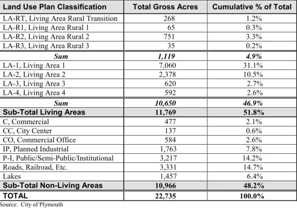
Table 3-2 provides a breakdown of future land uses within the city, calculated for each distinct land use classification.
TABLE 3-2
FUTURE LAND USE
Land Use Plan Classification Total Gross Acres Cumulative % of Total
LA-RT, Living Area Rural Transition 268 1.2%
LA-R1, Living Area Rural 1 65 0.3%
LA-R2, Living Area Rural 2 751 3.3%
LA-R3, Living Area Rural 3 35 0.2%
Sum 1,119 4.9%
LA-1, Living Area 1 7,060 31.1%
LA-2, Living Area 2 2,378 10.5%
LA-3, Living Area 3 620 2.7%
LA-4, Living Area 4 592 2.6%
Sum 10,650 46.9%
Sub-Total Living Areas 11,769 51.8%
C, Commercial 477 2.1%
CC, City Center 137 0.6%
CO, Commercial Office 584 2.6%
IP, Planned Industrial 1,763 7.8%
P-I, Public/Semi-Public/Institutional 3,217 14.2%
Roads, Railroad, Etc. 3,331 14.7%
Lakes 1,457 6.4%
Sub-Total Non-Living Areas 10,966 48.2%
When interpreting the Land Use Plan as found in Figure 3-1, the City will use the following guidelines:
Where applicable, the boundary between two land use classifications shall be considered to extend to the center of an adjacent street.
In undeveloped areas, the classifications on the plan assume that the boundary between classifications will follow major roads. Consequently, if the final alignment of a road changes from that shown on the map, the line on the Land Use Plan will also move to reflect the adjusted road alignment. For residential, commercial and industrial classifications, there is more than one corresponding zoning district. More than one district may be applicable to a particular site depending on: 1) the type and density/intensity of uses; 2) compatibility with the Comprehensive Plan, including public facilities (e.g. transportation and sanitary sewer); and 3) the purposes of the individual zoning district.
1
RESIDENTIAL LAND USES
Residential use is predominant in Plymouth, comprising just over half of the city’s total acreage. The Land Use Plan provides for a broad range of housing opportunities in eight different ―Living Areas.‖ Each specifies a range of acceptable densities. The City will continue to provide opportunities for a broad range of housing styles for people in all stages of the life cycle, from young adults to families with children to seniors. While the plan recognizes that the single family home is the most
dominant housing option in Plymouth, this plan strives to provide opportunities for a variety of housing styles developed in a range of densities.
The City has established minimum and maximum densities for each living area as illustrated in Figure 3-1. All new development will be required to meet the minimum density guidelines unless the developer can demonstrate that site characteristics make it infeasible to reach this goal. Density is based on the net acreage of the site (which
excludes wetlands and areas below the 100-year ordinary high water level for lakes and streams) divided by the number of dwelling units.
2
COMMERCIAL LAND USES
Commercial land uses occupy a relatively small amount of the City’s land area (just over five percent). However, their location and accessibility are critical to providing residents with necessary goods and services. The location of and access to a specific commercial site is directly related to the type and intensity of commercial use that the site can support.
The land use guide plan includes three commercial guiding designations, consisting of ―CO‖ (Commercial Office), ―C‖ (Commercial) and ―CC‖ (City Center). To protect the health, safety and general welfare of the surrounding uses and the community as a whole, proposed commercial developments must be carefully evaluated in terms of their access, location, size, intensity, traffic generation, context, site plan and building orientation, structural aesthetics and transition to
non-commercial uses. Access and how much traffic a proposed development will generate will be major considerations in determining the zoning for a commercially-guided site.
3
INDUSTRIAL LAND USES
Although residential use is the predominant land use in Plymouth, industrial land (not quite eight percent of the City’s land area) provides opportunities for much of
Plymouth’s employment base. Convenient locations with access to regional highway and railway routes and other services needed for business development have made Plymouth an important industrial employment center for the western part of the region. The jobs and tax base that industrial uses provide are important contributors to the economic vitality of the community.
With the continued evolution of the information age, Plymouth has seen a shift in the nature of its industrial users. Current trends show a greater amount of area devoted to office uses and the associated higher demand for parking. The City will need to
balance the demand for parking with other objectives, including limiting impervious surfaces and promoting travel demand management.
To protect the health, safety and general welfare of the surrounding uses and the community as a whole, the City must carefully evaluate industrial developments in terms of their access, location, size, intensity, traffic generation, context, site plan and building orientation, structural aesthetics and transition to non-industrial uses. Access and how much traffic a proposed development will generate will be major considerations in determining the zoning for an industrially-guided site.
4
PUBLIC/SEMI-PUBLIC/INSTITUTIONAL LAND USES
The objective of public, semi-public and institutional uses is to provide services, frequently on a non-profit basis, rather than the sale of goods and services. In Plymouth, public/semi-public uses make up roughly 14 percent of the city’s land area. Many of these uses, such as schools, churches and parks are essential to the creation of a healthy, well-balanced community. Others, such as public utility structures are essential to providing municipal sewer and water, which residents and businesses rely upon on a daily basis. Where these services are located is an important community consideration.
Some institutional facilities such as places of worship, schools, parks and recreation facilities can be suitably located in residential neighborhoods. Schools and parks in particular often become the focus of the neighborhood in which they are located. Public service facilities such as post offices and libraries are more appropriately located in or near neighborhood centers.
The development of other uses such as correctional treatment and detention facilities need to be carefully planned and regulated consistent with state law.
5
MIXED USE
The mixed use classification allows the integration of land uses of different intensity within close proximity. In the City of Plymouth, it means a developer can mix
residential and non-residential uses or different types of non-residential uses, which, in turn, can reduce reliance on the automobile and increase convenience for residents.
E
2030 CITYWIDE DEVELOPMENT
Combining forecast development in Northwest Plymouth and in the existing urban area, the City foresees development occurring at the levels and in the stages illustrated in Table 3-3. The table illustrates that Plymouth’s residential density in currently undeveloped areas will range from 3.11 units per acre to 5.95 units per acre.
Pa ge 19 of 22 C ha pte r 3 P lymo uth L an d U se P lan – A pri l 1 4, 2 00 9 TABLE 3-3
LAND USE IN 5-YEAR STAGES
Minimum Maximum A A.1 B C D
Residential Net Acres
LA-1 2 3 2.1 44.0 - 28.6 15.4 - - 46.0 92 138 LA-2 3 6 44.3 19.8 79.8 121.5 112.1 40.1 116.7 86.8 56.1 33.6 377.6 1,133 2,266 LA-3 6 12 24.4 46.7 15.3 1.7 19.0 38.1 4.9 0.9 0.9 88.2 529 1,058 LA-4 12 20 19.3 17.2 13.8 - 11.2 6.0 6.9 6.9 50.3 603 1,005 LA-R1 1 2 56.8 - - - 28.4 28.4 56.8 57 114 LA-R2 2 4 210.1 115.0 21.4 153.9 19.5 210.3 116.7 76.9 76.9 500.3 1,001 2,001 LA-R3 4 6 23.8 - 15.5 8.3 - - 23.8 95 143 Residential Subtotal 90.1 276.6 154.1 140.9 142.9 338.4 78.5 420.3 238.1 169.2 146.8 1,142.9 3,510 6,725 C/I Land Uses
C 4.4 3.8 8.2 8.2
CO IP
Public/Semi-Public Land Uses
P-I 3.1 94.9 77.0 69.4 175.0 Min.U/A Max U/A
Total 90.1 279.7 154.1 145.3 237.8 419.1 78.5 489.8 246.3 169.2 146.8 1,326.1 3.07 5.88
**Net Acres equals gross acres minus wetland, floodplain, ROW (arterials), parks, and buffers Source: City of Plymouth
Within Urban Service Area
Allowed Density Range
Housing Units/Acre Undeveloped within 2020 MUSA
Staging Area
2008-2010 2011-2015 2016-2020 2021-2025 2026-2030 Total Total Min. Units Total Max Units
F
CONSISTENCY WITH OFFICIAL CONTROLS
State law requires consistency between a community’s comprehensive plan and official controls. Whenever the City makes a change to its Comprehensive Plan, the City will review its official controls, including the Zoning Ordinance, to identify possible inconsistencies between the adopted plan and official controls. An inconsistency would be any official control that is in direct conflict with the goals and policies of the Comprehensive Plan.
To maintain consistency between the Land Use Plan and Zoning Map, the City will only rezone property consistent with the Land Use Plan. Appendix 3C identifies which zoning districts are generally consistent with each of the land use
classifications. Zoning districts not specifically identified under each land use classification may also be allowed if the resulting density and type of development are consistent with the Comprehensive Plan.
The City has established a uniform process and criteria for amending the Land Use Plan. The outline of the process and review criteria are found in Appendix 3D.
G
IMPLEMENTATION
The following specific implementation strategies are planned to carry out the Land Use Plan. These strategies are in addition to the enforcement of the City’s existing official controls (Zoning, Subdivision and other regulations that are part of the City Code) which are some of the most important tools for implementation of the City’s land use policies.
Description
Timing
Urban Service Area Expansion – Extend public sanitary sewer service to the
2030 urban expansion area in the general order as indicated by the development staging plan (see Figure 9-2).
Description
Timing
Zoning Map Amendments, Northwest Plymouth Overlay – Continue to use
the FRD (Future Restricted Development) zoning district as a holding zone within the urban service area until property is rezoned concurrent with review of development plans. Consider amendments to rezone property consistent with the 2030 Land Use Plan, provided that the development does not result in the
premature extension of public utilities, facilities and services.
Ongoing
Zoning Ordinance (Chapter 21, Plymouth City Code) – Draft new residential
zoning districts as necessary, that are consistent with the rural-to-urban guide plan classifications.
Short
Zoning Ordinance (Chapter 21, Plymouth City Code) – Review the ordinance
text and map to identify any inconsistencies with the Comprehensive Plan and propose amendments as necessary.
Short
Zoning Ordinance (Chapter 21, Plymouth City Code) – Consider amending the
ordinance to address the following issues:
Incentives to encourage clustering of buildings on sites with significant natural resources,
Architectural standards for all new attached housing units.
Short
Subdivision Regulations (Chapter 5, Plymouth City Code) – Consider an
amendment to address incentives for preservation of natural areas.
Short
City Center – Schedule additional streetscape improvements, including lighting,
landscaping, signage and street furniture as part of future Capital Improvement Programs.
Ongoing
Historic Preservation – Identify historic landmarks in the cityand work with
the Plymouth Historical Society to preserve and promote them.
CHAPTER 4
Housing Plan
Adopted
TABLE OF CONTENTS
A CHAPTER PURPOSE ...
1B GOALS AND POLICIES ...
1C HOUSING NEEDS ...
1 LIFE-CYCLE HOUSING ...
a Life Cycle Housing Indicators ...
b Housing Programs ...
c Fair Housing ...
2 AFFORDABLE HOUSING ...
a Affordable Housing Indicators ...
b Affordable Housing Programs ...
c Livable Community Housing Goals ...
3 HOUSING MAINTENANCE AND PRESERVATION ...
a Housing Condition Indicators ...
b Housing Maintenance Programs ...
3 4 4 5 6 6 6 7 7 8 8 9 D
IMPLEMENTATION
... 10LIST OF TABLES
4-1 Affordable Housing Opportunity Areas: 2011-2020 ... 8
LIST OF APPENDICES
4A HOUSING CHARACTERISTICS