Form-Based Codes:
A Step-by-Step Guide
for Communities
Acknowledgements
Special thanks to:
Daniel and Karen Parolek, Opticos Design, Inc.
Carol Wyant, Form-Based Codes Institute
Alan Mammoser, Form-Based Codes Institute
Heather Smith, Congress for the New Urbanism
Krysti Barksdale-Noble, United City of Yorkville
Jeff Brady, Village of Glenview
Robert Cole, Village of Oak Park
Kimberly Flom, Village of Orland Park
Bryan Gay, City of Crest Hill
Scott Magnum, Village of Des Plaines
David Mekarski, Village of Olympia Fields
Dustin Nilsen, Village of Antioch
Jeff O’Brien, Village of Downers Grove
Kimberly Stone, Village of Lockport
Additional thanks to the following firms for permission to use images of their work:
Dover, Kohl & Partners Farr Associates
Ferrell Madden/Code Studio The Lakota Group
Moule & Polyzoides, Architects and Urbanists Teska Associates
Torti Gallas and Partners Urban Advantage Urban Design Associates
The Chicago Metropolitan Agency for Planning (CMAP) is
the region’s official comprehensive planning organization.
Its GO TO 2040 planning campaign is helping the region’s seven
counties and 284 communities to implement strategies that address transportation, housing, economic development, open space, the environment, and other quality of life issues.
See www.cmap.illinois.gov for more information.
The Form-Based Codes Institute (FBCI) is a non-profit professional organization dedicated to advancing the understanding and use of form-based codes. FBCI pursues this objective through three main areas of action: developing standards for form-based codes, providing education, and creating a forum for discussion and advancement of form-based codes.
See www.formbasedcodes.org for more information.
Endorsed by
Table of Contents
Purpose of Handbook 5
GO TO 2040 5
Who Should Use This Handbook? 5
Introduction: What are Form-Based Codes? 7
Conventional Zoning 8
Form-Based Codes 9
Should Your Community Adopt a Form-Based Code? 11
Different Methods 12
Step One: Scoping 15
Who Should Be Involved? 16
Define Your Form-Based Codes Area 16
Planning Process 16
Relationship with Existing Regulations 17
Organizing Principle 17
Template Codes 18
Step Two: Assessing Existing Conditions 21
Community Sub-Areas 22
Smaller Scale Details 23
Step Three: Visioning and Creating Regulations 25
Engaging the Community 26
Explaining and Illustrating the Zoning Districts 27
Creating the Regulating Plan and Zoning District Regulations 33
Optional Components That May be Included in a Form-Based Code 37
Creating the Development Review Process 40
Conclusion 43
Hinsdale, Illinois. Credit: Hinsdale Magazine, Inc. | Hinsdale60521.com.
One of the central goals of the
GO TO 2040
comprehensive
regional plan is to make our region a better place to live. This
means creating livable communities at the local level through
planning and development decisions made by local government
officials, developers, and individuals. This handbook provides a
step-by-step guide to form-based codes, an alternative approach
to zoning.
GO TO 2040
GO TO 2040 states that defining “livability” is a challenge simply
because people’s values and priorities are so diverse. However, when residents across the region describe their values and priorities, certain commonalities of livability emerge. Livable communities are healthy, safe, and walkable. Livable communities offer transportation choices that provide timely access to schools, jobs, services, and basic needs. Livable communities are imbued with strength and vitality, features which emerge from preserving the unique characteristics that give our diverse communities “a sense of place.”
GO TO 2040 states that the building blocks of local planning are
comprehensive plans, consistent ordinances and other regulations, and trained decision-makers. Local comprehensive plans are the vision of what a community wants to become and the steps needed to meet that goal. Most communities find that a first necessary step to implement a comprehensive plan is to update their zoning ordinance.
As communities have sought to reinvigorate their downtowns or create viable commercial corridors, many have found that conventional methods of zoning, oriented around regulating land use, may not address certain physical characteristics that contribute to the sense of place in a community. While it is important to consider which uses should occur in a given place, we live in a visual world, and conventional methods of zoning often do not sufficiently address the fundamental aesthetic character of our communities — existing or desired.
Form-based codes, which emphasize the physical character of development, offer an alternative. This handbook explains what form-based codes are and how they are created to help communities assess whether they may be right for them.
Who Should Use
This Handbook?
Most communities lack the staff expertise and time necessary to develop a form-based code on their own and therefore choose to hire consultants to lead the effort and perform most of the work. However, it is vital that municipalities understand the scope of work that is required in the creation of a form-based code. Municipalities that educate themselves on the typical steps that are necessary will be in a better position to gauge the amount of outside assistance that is needed (and the amount of funding that will be required), write a more precise request for proposals (RFP), and evaluate consulting firms bidding for the project. Once the development of the form-based code is underway, well-informed municipal staff can better facilitate the process and monitor the work of hired consultants. Municipal staff will be responsible for administering the new form-based code once it is adopted, and possessing an understanding of how it was created is likely to provide a more nuanced appreciation of the reasons behind the regulations, as well as the amount of hard work that went into its creation.
Axonometric Diagram: Forecourt Plan Diagram: Forecourt Section Diagram: Forecourt
b
a
R.O.W
f d
e
g
f
d
a
R.O.W Parcel
e c
b a
R.O.W
Setback Line
Section Diagram: Stoop Axonometric Diagram: Frontyard / Porch Plan Diagram: Stoop
c
a
R.O.W Parcel Setback line
b R.O.W
e d
b a
R.O.W
d
a1
a1
Section Diagram: Frontyard / Porch Axonometric Diagram : Frontyard / Porch Plan Diagram: Frontyard / Porch
e
a
R.O.W Parcel Setback Line
c
d b
R.O.W
a
e
d c
a1
b a
R.O.W
a1 e
e
a1
a1
a1
a1
Architectural Standardards - Frontage Types, Transit Zoning Code (2010), City of Santa Ana, California. Credit: Moule & Polyzoides, Architects and Urbanists.
Nearly everyone can identify things they like in their community
and things they want to change. Whether a favorite house, street,
or place, it’s common to wonder why there isn’t more of what we
like and less of what we don’t.
There are many reasons for this dissatisfaction with the physical
character of many of our communities, especially the quality
of the public realm. One reason is that conventional methods
of zoning, which are focused on what uses are permitted, have
often shaped the form of the built environment in unintended—
and occasionally unwanted—ways.
Form-based codes include specification of what uses are
permitted in a building or place, but focus on the physical
character of development, particularly how it relates to the
public realm that everyone shares. A growing number of
communities across the country and in our region have found
that form-based codes are a more precise and reliable tool for
achieving what they want, preserving what they cherish, and
preventing what they don’t want.
Introduction
What are
Form-Based Codes?
Conventional Zoning
Conventional methods of zoning arose out of the need to protect public health, safety, and welfare by preventing the most negative impacts of siting, size, and use of buildings. Limiting the spread of fire from one building to another, providing access to sunlight and air, and separating smoke-producing industry from residential uses are but a few of the worthy objectives that conventional zoning was intended to fulfill.
In addition to helping protect public health, safety, and welfare, conventional zoning was meant to protect property values by separating incompatible uses in a particular area or district. This separation is typically accomplished by creating single- or limited-use zones that segregate different land limited-uses, such as residential and commercial.
Fueled in part by rapid national growth in population and gross domestic product that followed the end of World War II, the practice of separating “incompatible” land uses led to the near universal segregation of different land uses—often at great distance from one another. As a result, cities and towns have increasingly been placing residential uses in one area, commercial in another, and industrial in still another.
In particular, conventional zoning tends to isolate single-family homes from all other types of development. The development resulting from such zoning requirements often makes it difficult, if not impossible, to walk from home to purchase a quart of milk. Public transportation has become increasingly less efficient in these areas, and travel by personal automobile has often made more sense. Accordingly, maximizing the flow of traffic has been a top priority for street design, which has increasingly yielded streets designed for car travel, not pedestrians.
Over the decades, these and other related factors shaped the urban environment of many communities. Often a community’s unique “sense of place” has been diminished—or, in many new communities, was never achieved in the first place.
In general, conventional zoning:
• Separates uses related to daily activity, such as home, school, and work.
• Frequently promotes low-density development and relatively limited housing choices.
• Often encourages excessive land consumption and automobile dependency.
• Ends up focusing on what uses are not allowed, rather than encouraging what the community actually wants.
• Applies standards and design requirements generically, in a “one-size-fits-all” manner, throughout the entire community.
• Uses regulations such as floor area ratio, which can shape the form of development in ways that are hard to visualize beforehand and may encourage developers to “max out” the massing of a building within allowed limits, often at the expense of its architectural detailing and sensitivity to existing context.
• Regulates private development, but typically not the design or character of the streets that serve it. This usually leaves development of standards to the city engineer or public works department, which tend to focus on accommodating automobile traffic.
Ultimately, development and street standards in conventional zoning often do not promote the type of development envisioned by a community’s comprehensive plan, and even when created with the best of intentions, they can undermine the very plans they are supposed to support.
Chicago suburbs from the air. Credit: Flickr user Shawndra and Simon.
Form-Based Codes
In the 1980s, a group of planners and architects sought to create an alternative to conventional zoning, focused less on use and more on scale, intensity of development, the shape of public spaces, and the interrelationships between buildings. During this period, the design firm Duany Plater-Zyberk & Company drafted what was effectively the first modern form-based code to guide the development of Seaside, Florida, a new community based on traditional neighborhood design principles. A radical departure from conventional zoning, the entire “Urban Code” for Seaside was graphically presented on one poster.
But what are form-based codes? Form-based codes are a method of development regulation, adopted into municipal or county law, that emphasizes the physical character of development (its form) and includes—but often de-emphasizes—the regulation of land uses. As in a conventional zoning ordinance, land uses are regulated, but land use is typically regulated more broadly, with land use categories in lieu of long lists of specific permitted uses.
A form-based code focuses on how development relates to the context of the surrounding community, especially the relationships between buildings and the street, pedestrians and vehicles, and public and private spaces. The code addresses these concerns by regulating site design, circulation, and overall building form. Due to this emphasis on design, form-based codes usually provide greater predictability about the visual aspects of development, including how well it fits in with the existing context of the community. They offer a community the means to create the physical development it wants and developers a clearer understanding of what the community seeks. Over time, these benefits can foster greater community acceptance of new development.
A form-based code can be customized to the vision of any community, including preserving and enhancing the existing character of one neighborhood or dramatically changing and improving the character of another. Typically, they do both. But how do form-based codes differ from conventional zoning? In general, a form-based code:
• Encourages a mix of land uses, often reducing the need to travel extensively as part of one’s daily routine.
• Promotes a mix of housing types.
• Is “proactive,” focusing on what the community wants and not what it dislikes.
• Results from a public design process, which creates consensus and a clear vision for a community, to be implemented by the form-based code.
• Tailors the requirements to fit specific places or neighborhoods by reflecting local architecture and overall character.
• Emphasizes site design and building form, which will last many years beyond specific numerical parameters such as density and use regulations that are likely to change over time.
• Addresses the design of the public realm and the importance that streetscape design and individual building character have in defining public spaces and a special “sense of place.”
• Provides information that is easier to use than conventional zoning codes because it is shorter, more concise, and emphasizes illustrations over text.
Urban Code (1986), Town of Seaside, Florida. Credit: Duany Plater-Zyberk & Company.
Toft Avenue improvements, Downtown Form-Based Code (2010), Village of Antioch, Illinois. Credit: The Lakota Group.
SmartCode Transect Map
SmartCode Transect Map with existing buildings added
1
2
3
4
5
6
New commercial and office buildings are clustered at intersections
New residential units locate at intersections; planned corridor de-velopment connects intersections.
Clustered, mixed-use areas become neighborhoods and urban centers which attract new development.
The SmartCode requires street trees in the public and private realm. In time, an urban canopy is created.
SMARTCODE DEVELOPMENT ILLUSTRATED
Comparison of typical development patterns under conventional zoning and the SmartCode form-based code template, Downtown Montgomery Plan (2007), City of Montgomery, Alabama. Credit: Dover, Kohl & Partners.
SmartCode Transect Map
SmartCode Transect Map with existing buildings added
1
2
3
4
5
6
New commercial and office buildings are clustered at intersections
New residential units locate at intersections; planned corridor de-velopment connects intersections.
Clustered, mixed-use areas become neighborhoods and urban centers which attract new development.
The SmartCode requires street trees in the public and private realm. In time, an urban canopy is created.
SMARTCODE DEVELOPMENT ILLUSTRATED
1
2
3
4
5
6
Current zoning ordinance map with existing buildings
The intent of the conventional ordinance is the segregation of uses. Different building uses are shown with different colors.
New development and redevelop-ment can occur in any commercial zoning, unconnected to each other.
Years worth of office space growth are "spent" on self-contained tow-ers with no effect on city vitality.
Isolated new commercial uses and self-contained towers do not contribute to the creation of complete neighborhoods. Current zoning ordinance map
CONVENTIONAL DEVELOPMENT ILLUSTRATED
Should Your Community Adopt a Form-Based Code?
Before embarking on the creation of a form-based code, a community needs to carefully consider whether a form-based code is the right tool to achieve community goals for the built environment. Current regulations may be sufficient. A key indicator is whether the community has experienced a substantial amount of new development in recent years and if there is broad satisfaction with the built environment of a community (buildings, streets, public spaces, etc.). It is common for residents to express high satisfaction with their community’s built environment when it has remained largely unchanged over several decades, often the result of strict preservation laws or low demand for new development.
A Means of Preservation and Transformation
If current regulations are not sufficient, form-based codes can preserve what residents love about the physical character of their community, ensuring that future development is in harmony with existing context or facilitating varying degrees of change. Either way, the main purpose of a form-based code is to proactively regulate the physical form and character of new development so that the community gets what it wants, rather than reacting to those elements of each development proposal on a piecemeal basis (or not at all). It should be noted that while conventional architectural standards can be effective at preserving context, they are often applied subjectively. In addition, some architectural standards lack the necessary scope of regulation, leading to unforeseen consequences, such as new development that follows the letter of the law but only superficially fits in with existing context. For example, architectural standards may permit the construction of an outsized, modern building on a lot located between two historic cottages once the developer agrees to paste decorative shutters on the building’s facade. Form-based codes are typically more comprehensive and directly address the aspects of building form that most impact the relationship between buildings and the public realm as a whole.
An Adaptable Approach
Form-based codes are not “one-size-fits-all,” but are tailored to the local context, objectives, and means of each community. These considerations include the community’s existing physical character and goals for preservation or transformation, as well as its local political landscape and what financial and staff resources are available to support the effort.
Increasing Predictability, Lowering Risk,
and Expanding Options for Developers
Nevertheless, it is common for municipalities to be wary of adopting new development regulations, especially in difficult economic times. Although the adoption of any new form-based code will require developers, not to mention municipalities, to learn a new system of development regulation, comprehensive form-based codes have the potential to encourage and facilitate development more effectively than conventional regulations. Form-based codes are often easier to follow than conventional codes and ultimately more comprehensive, providing municipalities and potential developers with a system that, once learned, is more transparent, predictable,
and thorough. As an added benefit, the need for review by a discretionary body such as a planning commission or design review board is often eliminated.
In addition, form-based codes typically—but not always— reduce regulation of what uses are allowed within buildings. This can expand the potential market for new development and result in structures that are more adaptable to different kinds of tenants, today and throughout the evolution of the community over many decades.
Photo simulation of proposed changes to Sheridan Road, Heart of Peoria Land Development Code
12
Different Methods
There are many approaches to creating a form-based code. Nevertheless, most methods share many of the same steps and specific practices. The Form-Based Codes Institute (FBCI,
www.formbasedcodes.org), led by Carol Wyant (who first
coined the term “form-based codes”), is a non-profit professional organization dedicated to advancing the understanding and use of form-based codes. FBCI offers an introductory webinar on the “ABCs of Form-Based Codes” and advanced, two-day courses on creating, adopting, and administering form-based codes.
Architects Daniel and Karen Parolek of Opticos Design, Inc. are both on the FBCI Board of Directors and frequently serve as instructors for FBCI’s courses and webinars. Drawing upon years of experience developing award-winning form-based codes for communities across the nation, they wrote (with Paul Crawford) the influential textbook Form-Based Codes: A Guide for Planners, Urban Designers, Municipalities, and Developers (2008), which offers a highly-detailed, comprehensive process for creating a form-based code that impressively incorporates established best practices.
Their process may differ from that used by many consulting firms specializing in form-based codes, who often follow a highly customized process they’ve crafted over the years. But in order to provide municipalities in our region with an idea of what the creation of a form-based code could entail, a synopsis of the steps recommended by the authors follows. The steps include:
Step 1: Scoping defines the area of the community to be addressed
through the form-based code and the extent to which form-based codes interact with existing regulations.
Step 2: Assessing Existing Conditions documents and analyzes
the community’s existing urban form at different scales, providing a basis for the creation of the form-based code.
Step 3: Visioning and Creating Regulations defines the
community’s vision for its future and determines the specific regulations and procedures of the form-based code.
FORM-BASED CODES: A STEP-BY-STEP GUIDE FOR COMMUNITIES
Thoroughfare standards for Orchard Street in Transitional Core District, Downtown Form-Based Code (2010), Village of Antioch, Illinois. Credit: The Lakota Group.
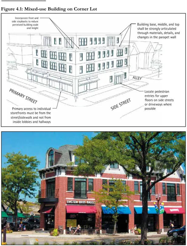
Glenview Downtown Development Code
June 17, 2008, Ordinance Number: 5112
Article 4: Design Standards
61
Building Types
4.6.1 Mixed Use
Figure 4.1: Mixed-use Building on Corner Lot
Example of mixed-use building on corner lot with articulated architecture.
McLEAN COURT
MAPLEWOOD LANE
AVENUE
LAKE
STEVENS DRIVE
TA
LL
TR
EE
STREET STREET
STREET
PINE
PINE
PINE COURT
LANE
TINKER
W AY
SLEE PY
HOLL OW
ROAD
WILLOW LANE
WOODVIEW
TINKER
W
AU
KEGA
N
GROVE
HUTCHINGS
DEWES STREET
STREET
AV EN
UE
STREET STREET
STREET
PRAIRIE GROVE
PINE
CHURCH
RA ILR
OAD AVEN
UE
DEPOT
WASHINGTON
ROAD
HENLEY
STREET
AVENUE
RA ILROA
D AV
EN UE LEH
IGH
PRAIRIE
GLENVIEW GREEN
AVENUE
STREET
VERNON
RALEIGH
ROAD
ROAD
HARLEM
ROAD
Not To Scale
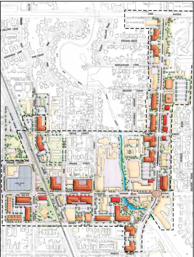
Village of Glenview, Illinois
Figure 1: Downtown Plan (approved November 2006)
Downtown Development Code
March 2, 2007 Downtown Revitalization Plan (2006), Village of Glenview, Illinois. Credit: The Lakota Group.
Step One
Scoping
Once a municipality chooses to develop a form-based code,
there are several questions the community will need to carefully
consider at the beginning of the process, such as:
What staff should be involved?
How much help will we need from consultants?
Should the new form-based code cover the whole community, or
just part of it?
How much change do we want?
The answers to these essential questions will determine the
scope of the form-based code.
Municipal Staff
Key municipal departmental staff are essential to the creation of the form-based code, participating—at a minimum—in an initial assessment of the existing zoning regulations, community visioning sessions and workshops, and code drafting and review. Departments that typically participate include planning, public works, parks and recreation, economic development, police, and fire.
Consultant Assistance
Consultants are typically engaged to augment the expertise of the municipal staff and often to lead the effort. These consultants are usually planners, architects, or urban designers. Depending on the focus and objectives of the form-based code effort, the consultant team could also draw on expertise from disciplines such as
transportation planning, market analysis, historic preservation, legal support, and public participation. FBCI provides sample Request for Qualifications (RFQs) and RFPs at www.formbasedcodes.org.
Define Your
Form-Based Codes Area
Form-based codes can be applied at a variety of scales. Examples include:
• Sub-areas within a municipality: Downtowns
Deteriorating strip commercial corridors “Dead” big-box shopping centers
One or more undeveloped “greenfield” areas adjacent to a municipality that are intended to accommodate growth Existing neighborhoods or other developed areas where infill development is intended to preserve or extend existing patterns of physical character
• Entire municipalities
• Counties or regions that include both urban areas and countryside
• Areas that have been targeted for economic revitalization, are undergoing changes in land ownership, or are the location of planned infrastructure improvements
Planning Process
Form-based codes are typically created by integrating a planning process with the drafting of specific rules for development. Communities will need to take into consideration the timing of the most recent comprehensive plan update and whether the update included sufficient engagement with the community and urban design specifications in the plan, as well as the amount of funding available for the development of the form-based code.
FORM-BASED CODES: A STEP-BY-STEP GUIDE FOR COMMUNITIES 16
Who Should Be Involved?
Form-based codes address both the short- and long-term interests of several specialized areas. Therefore, it is vital to assemble a diverse team to lead the creation of the form-based code. Typically, this code team is composed of municipal staff with consultant assistance, frequently with the consultant team responsible for guiding the effort and completing the majority of tasks required by the planning process.
Testing the Waters
Some municipalities may choose to first create a form-based
code for a limited area before applying the techniques to more extensive areas or to the entire municipality. This may be due
to uncertainty among elected officials and residents or a desire
to create a pilot project that will provide an opportunity for
municipal staff and elected officials to gain experience.
Photo simulation of proposed changes to Dexter Avenue, Downtown Montgomery Plan (2007),
Relationship with
Existing Regulations
There are several different methods for introducing form-based codes into an established zoning ordinance. Their suitability often depends upon the degree of change that is desired by the community and a realistic assessment of political feasibility.
Comprehensive Replacement of Existing Code
The form-based code replaces the existing conventional zoning code for all or part of a community, and all development within the area must abide by the regulations of the form-based code. This approach generally offers the widest range of opportunities for transforming a targeted area of a community while maintaining established character in others. It also offers the advantage of consistency in regulatory vocabulary and procedures throughout the code.
Hybrid Zoning Code
A hybrid code is one that combines form-based zoning districts, and potentially other form-based standards, with a conventional zoning approach. Form-based standards can be merged with the existing conventional code or created in conjunction with new conventional zoning standards. A hybrid code can take the form of a chapter within the code, similar to a special district or overlay. The hybrid form-based code is cross-referenced to other sections of the pre-existing code for selected development standards, such as parking dimensions or landscaping standards. Areas that fall within the form-based code boundaries are rezoned to new zoning districts per the code. Within these areas, any and all development must abide by the new regulations for the form-based zones. This approach can be used for a sub-area in the phased replacement of an existing code, and can also be an effective way of responding to pressure for physical change in “sensitive” areas of the community.
Optional/Parallel Code
The form-based code is created as a standalone code but does not replace the existing conventional zoning code. Instead, in specific areas defined in the form-based code, the developer is given the choice to build under the existing conventional zoning or the new form-based code. The property does not have to be rezoned, but once the developer chooses a code, the entire development project must abide by it.
There are advantages to this approach, but the challenges of administering even a single zoning code are significant, and two codes may create confusion about the community’s commitment to the requirements and principles reflected in the form-based code. It may also result in developers attempting to pick and choose only those form-based code requirements that are most beneficial to their interests.
Organizing Principle
There are many different approaches to regulating the type, scale, form, and intensity of allowable development in a form-based code. Some common approaches are explained below, but it is important to note that any consulting firm that specializes in form-based codes is likely to have its own individualized approach.
Transect-Based Codes
Many form-based codes are organized using the concept of a rural-to-urban “transect,” in which zones are primarily classified by the physical intensity of the built form, the relationship between nature and the built environment, and the complexity of uses within the zone (please see diagram below explaining the concept). This allows for a gradual transition between different areas in a community. Applying the concept of the transect to a particular planning area often results in a modified version that responds to local conditions; indeed, this is how the transect-based SmartCode, a form-based code template, functions (an explanation of the SmartCode is provided on the following page).
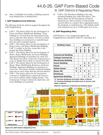
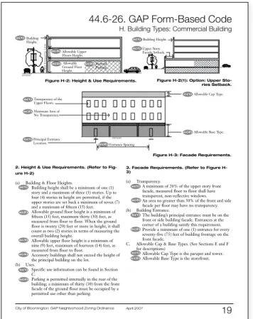
Building Type-Based Codes
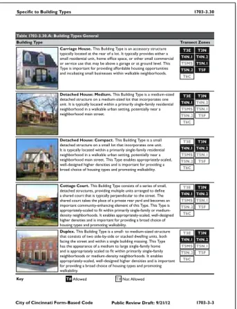
In this common approach, the form-based code is organized through different building types, each defined by specific
development standards regulating the configurations, features, and functions of buildings. The building types and their accompanying development standards are applied to different blocks and districts within the planning area.
This approach is thought to work best in smaller planning areas, especially infill development, where the compatibility of new development with existing buildings is a high priority. In this scenario, the use of building types can reinforce the existing character of a community.
The Transect. Credit: Topografis PC.
FORM-BASED CODES: A STEP-BY-STEP GUIDE FOR COMMUNITIES 18
Street-Based Codes
Street-based codes are form-based codes that are organized by different street types, such as boulevards, arterials, and collectors. Each street type is defined by the level of traffic the roadway is designed to accommodate, design speeds, pedestrian crossing times, the width of vehicle lanes and sidewalks, the configuration of on-street parking, the presence of medians bicycle lanes, and other factors, including how buildings are required to address the street (in terms of height, frontage type, and build-to lines). Street-based codes are typically illustrated using section drawings.
Template Codes
A form-based code can be designed and developed locally from scratch or based on a predetermined “template” that has been used elsewhere and can be customized to serve local needs.
SmartCode
The most notable currently available code template is the SmartCode. It was originally created by the architectural firm of Duany Plater-Zyberk & Company and has since undergone continual refinement by the firm, other planning and design professionals, and communities that have used the code.
The SmartCode is a comprehensive, transect-based form-based code template (or “model ordinance”) that includes model language, standards, and requirements for multiple scales of development by public and private sectors, as well as administrative procedures for development review and approval. It is intended to be customized to the local context, priorities, and legal requirements of each community that uses it.
It has been used by several communities across the U.S., and in its largest implementation to date, it was used as the basis for the new development code for the City of Miami, Florida.
Other templates
Consultant teams that have prepared more than a few form-based codes are likely to have developed at least one form-based code template. If the consultant team is based in the region, it is likely that their template will likely be customized to the local context and legal requirements of the municipality.
Considerations for Templates
If the form-based code will apply to an area composed of only one transect level, a transect-based approach such as the SmartCode may not be necessary. Also consider the extent
to which local officials (particularly municipal attorneys) are confident that the template can be sufficiently calibrated to
and customized to comply with applicable state law requirements, including consistency with the municipality’s comprehensive plan.
1.!Two"Lane!Avenue!
A wide median and plentiful street treesmake the Two Lane Avenue a quiet address especially well suited to residential and office uses.
Notes:!!
1. Appurtenances may extend beyond the
height limit.
2. Building fronts are required to provide
shelter to the sidewalk by means of at least one of the following: arcade, colonnade, marquee, awning, or second-floor balcony.
3. The alignment of floor-to-floor heights of
abutting buildings is encouraged to allow for shared use of elevators.
A.!Building!Placement:
Build-to-line location: 0–10 ft. from property line Space Between
Buildings:
0 ft. if attached 6–10 ft. if detached
B.!Building!Volume:!!
Bldg. Width: 16 ft. minimum 160 ft. maximum Bldg. Depth: 125 ft. maximum Bldg. Height: 2 stories minimum
4 stories maximum 55 ft. maximum The first floor shall be a minimum of twelve (12) feet in height
!
II-5 July 16, 2001
5.01.090 Building Types
5-16 Livermore Development Code
Five attached townhouses designed with a single simple plane. Elevated covered stoops provide a secondary rhythm along the street.
Four attached townhouses designed with a simple massing with a continuous porch. The dormers and slight plane shift in the end units help to break down the overall massing.
Three attached townhouses designed with a simple massing. Individual porches and gable ends on the end units provide the secondary rhythm.
5.01.090 Townhouse
General Note: the drawings and photos below are illustrative.
A. Description
The Townhouse building type consists of structures that contain three or more dwelling units placed side by side. A small side or rear yard is provided for each unit as private open space. This building type provides a higher-density, fee-simple unit in a more urban form.
Building Types: Townhouse, Development Code (2010), City of Livermore, California. Credit: Opticos Design, Inc.
Street Types: Two-Lane Avenue, Central Hercules Plan (2001), City of Hercules, California. Credit: Dover, Kohl & Partners.
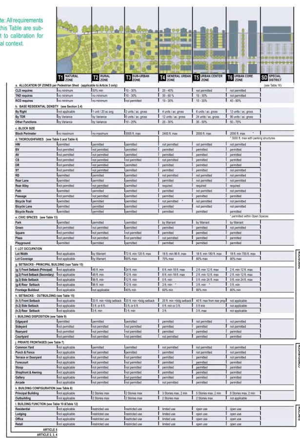
SMarTCoDe
Municipality
SmartCode VerSion 9.2
sc42
T1 naTural zone T2 rural zone T3 zoneSuB-urBan T4 General urBan zone T5urBan CenTer zone T6urBan Core zone
SD SPeCIal DISTrICT
note: All requirements in this table are sub-ject to calibration for local context.
a. alloCaTIon oF zoneS per Pedestrian Shed (applicable to article 3 only) (see table 16)
ClD requires no minimum 50% min 10 - 30% 20 - 40% not permitted not permitted
TnD requires no minimum no minimum 10 - 30% 30 - 60 % 10 - 30% not permitted
rCD requires no minimum no minimum not permitted 10 - 30% 10 - 30% 40 - 80%
b. BaSe reSIDenTIal DenSITY (see Section 3.4)
By right not applicable 1 unit / 20 ac avg. 2 units / ac. gross 4 units / ac. gross 6 units / ac. gross 12 units / ac. gross
By TDr by Variance by Variance 6 units / ac. gross 12 units / ac. gross 24 units / ac. gross 96 units / ac. gross
other Functions by Variance by Variance 10 - 20% 20 - 30% 30 - 50% 50 - 70%
c. BloCK SIze
Block Perimeter no maximum no maximum 3000 ft. max 2400 ft. max 2000 ft. max 2000 ft. max *
d. ThorouGhFareS (see Table 3 and Table 4) * 3000 ft. max with parking structures
hW permitted permitted permitted not permitted not permitted not permitted
BV not permitted not permitted permitted permitted permitted permitted
aV not permitted not permitted permitted permitted permitted permitted
CS not permitted not permitted not permitted not permitted permitted permitted
Dr not permitted not permitted permitted permitted permitted permitted
ST not permitted not permitted permitted permitted permitted not permitted
rD permitted permitted permitted not permitted not permitted not permitted
rear lane permitted permitted permitted permitted not permitted not permitted
rear alley not permitted not permitted permitted required required required
Path permitted permitted permitted permitted not permitted not permitted
Passage not permitted not permitted permitted permitted permitted permitted
Bicycle Trail permitted permitted permitted not permitted * not permitted not permitted
Bicycle lane permitted permitted permitted permitted not permitted not permitted
Bicycle route permitted permitted permitted permitted permitted permitted
e. CIVIC SPaCeS (see Table 13) * permitted within open spaces
Park permitted permitted permitted by Warrant by Warrant by Warrant
Green not permitted not permitted permitted permitted permitted not permitted
Square not permitted not permitted not permitted permitted permitted permitted
Plaza not permitted not permitted not permitted not permitted permitted permitted
Playground permitted permitted permitted permitted permitted permitted
f. loT oCCuPaTIon
lot Width not applicable by Warrant 72 ft. min 120 ft. max 18 ft. min 96 ft. max 18 ft. min 180 ft. max 18 ft. min 700 ft. max
DISP
oSITI
on
lot Coverage not applicable by Warrant 60% max 70% max 80% max 90% max
g. SeTBaCKS - PrInCIPal BuIlDInG (see Table 15)
(g.1) Front Setback (Principal) not applicable 48 ft. min 24 ft. min 6 ft. min 18 ft. max 2 ft. min 12 ft. max 2 ft. min 12 ft. max
(g.2) Front Setback (Secondary) not applicable 48 ft. min 12 ft. min 6 ft. min 18 ft. max 2 ft. min 12 ft. max 2 ft. min 12 ft. max
(g.3) Side Setback not applicable 96 ft. min 12 ft. min 0 ft. min 0 ft. min 24 ft. max 0 ft. min 24 ft. max
(g.4) rear Setback not applicable 96 ft. min 12 ft. min 3 ft. min * 3 ft. min * 0 ft. min
Frontage Buildout not applicable not applicable 40% min 60% min 80% min 80% min
h. SeTBaCKS - ouTBuIlDInG (see Table 15)
(h.1) Front Setback not applicable 20 ft. min +bldg setback 20 ft. min +bldg setback 20 ft. min +bldg setback 40 ft. max from rear prop not applicable
(h.2) Side Setback not applicable 3 ft. or 6 ft. 3 ft. or 6 ft. 0 ft. min or 3 ft. 0 ft min not applicable
(h.3) rear Setback not applicable 3 ft. min 3 ft. min 3 ft. 3 ft. max not applicable
i. BuIlDInG DISPoSITIon (see Table 9)
edgeyard permitted permitted permitted permitted not permitted not permitted
Sideyard not permitted not permitted not permitted permitted permitted not permitted
rearyard not permitted not permitted not permitted permitted permitted permitted
Courtyard not permitted not permitted not permitted not permitted permitted permitted
j. PrIVaTe FronTaGeS (see Table 7)
Common Yard not applicable permitted permitted not permitted not permitted not permitted
Con
FIG
ura
TI
on
Porch & Fence not applicable not permitted permitted permitted not permitted not permitted
Terrace or Dooryard not applicable not permitted not permitted permitted permitted not permitted
Forecourt not applicable not permitted not permitted permitted permitted permitted
Stoop not applicable not permitted not permitted permitted permitted permitted
Shopfront & awning not applicable not permitted not permitted permitted permitted permitted
Gallery not applicable not permitted not permitted permitted permitted permitted
arcade not applicable not permitted not permitted not permitted permitted permitted
k. BuIlDInG ConFIGuraTIon (see Table 8)
Principal Building not applicable 2 stories max 2 stories max 3 stories max, 2 min 5 stories max, 2 min 8 stories max, 2 min
outbuilding not applicable 2 stories max 2 stories max 2 stories max 2 stories max not applicable
l. BuIlDInG FunCTIon (see Table 10 &Table 12)
residential not applicable restricted use restricted use limited use open use open use
Fun
CTI
on
lodging not applicable restricted use restricted use limited use open use open use
Office not applicable restricted use restricted use limited use open use open use
retail not applicable restricted use restricted use limited use open use open use
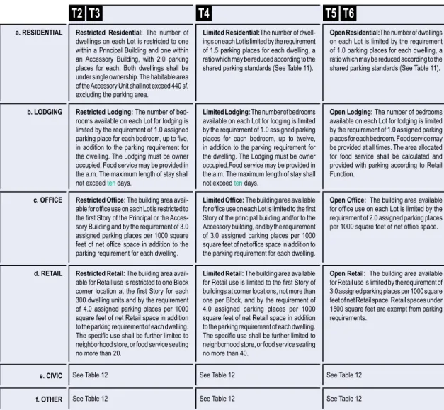
arTICle 5 arTICle 2, 3, 4
TaBle 14. SMarTCoDe SuMMarY
Rockville Town Center
Existing Framework
Gateway
Town Center Focal Point Major Pedestrian Spine
Major Vehicular ThoroughfareV
Critical Connection Railroad
Transitional Office Zone Neighborhood
Auto-Oriented Commercial Distinctive Core Area
(high density, mixed-use, pedestrian orientation)
Spring Avenue Frederick Avenue
Lincoln Avenue
Howard Avenue
Crabb Avenue
Park Road
Woodland Road
Nort h Stonestree
tAvenue
Stonestree t Avenue
Veirs Mill Road WoottonParkway
evi rD n ot s n o m d E
M/ ev ir D dr of re gn u H
D Rout
e355
ek iP ell iv kc o R
Martin s Lane
North Street
W
ht
ro
N
te
er
tS
no
tg
ni
hs
a
Beall Avenue
e n a L e l d d i M t s a E
Montgomery Avenue
Monroe Street Jefferson Street
Wood Lane
Vinson Street
Flee t Street
Marylan d Avenue
Monro eStreet
Richar dMontgomer
yDrive
Verno n Place
e ki P el li v k c o R
MD355
Existing Framework, Town Center Master Plan (2001), City of Rockville, Maryland. Credit: Development Concepts, Inc./HNTB. 20
Step Two
Assessing Existing
Conditions
A form-based code guides development to build upon and
strengthen the unique characteristics of a community, helping
to preserve desired character. Before a form-based code is
created, the code team identifies these unique characteristics by
documenting and analyzing the community’s existing urban form
at different scales, from the broad characteristics of a community’s
neighborhoods to the specific architectural details of windows
on typical houses within each neighborhood. The information
gathered during this phase is organized and analyzed to provide a
basis for the creation of the form-based code.
It should be noted that the following approach to documenting
and analyzing existing conditions is not standardized, so a variety
of approaches are possible. Many form-based code consultants
choose a different process, such as documenting large and small
scale elements simultaneously, rather than in two phases.
FORM-BASED CODES: A STEP-BY-STEP GUIDE FOR COMMUNITIES 22
Community Sub-Areas
Documenting the existing conditions of a community’s sub-areas helps the code team understand the composition of the community at a larger scale. Some common sub-areas that can be identified include:
Neighborhoods, which usually are areas that contain blocks or
buildings that are unified in character or style. A neighborhood is often walkable and may have a clearly defined center or edge.
Districts, which are areas typically defined by a particular use or
activity, such as light industrial districts.
Corridors, which can be man-made elements relating to movement,
such as roads or railways, or natural elements such as rivers. Whether man-made or natural, these corridors often define boundaries within and between neighborhoods. However, roads that function as commercial corridors often serve as the center of many communities.
Preparation
Reviewing Background Documents
With the help of municipal staff, the code team should gather existing background documents, such as maps and past plans, for the area. These documents provide immediate context for the code team’s analysis and will help them develop a form-based code that accommodates and works with existing regulations that will remain in effect after the form-based code is implemented. In addition, it is important for the code team to review any regulations that are being replaced in order to help understand the existing place and to learn from those regulations’ successes and failures. Similarly, studying past plans can help the team to incorporate any previous visioning work that was completed by the community prior to the form-based code process.
Mapping Existing Conditions
To understand existing conditions and select areas to focus on during the site visit, the code team may create an existing conditions map with information such as public right-of-way lines, lot lines, building footprints, curbs and sidewalk locations, existing land uses, parking location, and natural features (such as rivers) that will impact development.
The code team will review these maps, looking for patterns and marking up the maps with the existing neighborhood, district, and corridor framework of the community. In addition, the team will usually mark the map in response to questions about the physical form of the community (please see inset above). If the team anticipates a transect-based form-based code (see page 17), it might begin to make an initial list of transect levels that are likely to be included in the form-based code.
Site Visit
Members of the code team will often visit the study area to determine the centers and boundaries of any neighborhoods, districts, and corridors, then mark them on a map (such as an existing conditions map created before the site visit).
Neighborhoods
For neighborhoods, the code team will often try to locate its center (which is a crossroad, commercial center, school, government building, or park) as well as its outer boundary (typically a street, rail line, or creek). The team is likely to take photographs intended to illustrate the physical character of each neighborhood; these photographs may be used later on to help the team determine which transect level is applicable to the neighborhood. The code team is likely to make an initial assessment of how much each neighborhood should change (such as “preserve,” “preserve and enhance,” “evolve,” and “transform”). If relevant to the project, the team may note potential locations for new neighborhoods and neighborhood centers.
Site visit, Downtown Montgomery Plan (2007), City of Montgomery, Alabama. Credit: Dover, Kohl & Partners.
Analyzing Existing
Conditions Maps
Existing conditions maps can be marked in response to any of the following questions:
• Where are the centers or focal points?
• Which streets and roadways are regional connectors? Which are local connectors?
• Where are the green or pedestrian corridors?
• Which areas are currently slated for major changes in scale and/or use?
• Which places define the community’s identity? Are historic
developmental patterns intact in any of these places?
• Where do building and street patterns change and what might be the reason?
• Which neighborhoods would benefit from the preservation of
their existing character?
• Are there any districts that are expressly zoned for a particular use or activity, such as light industry?
• Are there clear edges and transitions between neighborhoods? • Which transect levels exist within the community?
Districts
The code team usually will also mark any identified districts (on the existing conditions map, or equivalent), and take photographs of the area. If there are any districts, the team should assess the relationship of each district to the community, determining whether it is a healthy component of the community (such as an educational campus), an incompatible-use district (such as a heavy industrial area), or an area unnecessarily zoned as a district (such as single-use districts that could be appropriately placed within a mixed-use district). In addition, the team should consider whether each necessary district will need to expand in the future.
Corridors
The code team may also mark the location of any corridors, such as important roads, trails, or streams, and consider how the corridor is functioning as an element of the built environment and whether there is a balance between auto and pedestrian traffic.
Special Conditions
The team will usually note any other unique larger elements of the area, such as topography.
Organizing the Data
According to a methodology that is most helpful to them, the code team may create a series of spreadsheets, diagrams, or maps to organize the information from the site visit. Some teams may find it helpful to compile the data from all maps and diagrams onto a single summary diagram (some firms refer to this as an “existing framework diagram”).
If developing a transect-based form-based code, the team will likely review the summary diagram for the various transect levels noted for each neighborhood during the first round of site visits. Any photographs taken during the site visit will usually be organized by transect level. The code team may then create an “existing transect diagram,” which includes all neighborhoods and indicates which transect levels are found in each, usually illustrated by photographs from the site visits.
Smaller Scale Details
Documenting the existing conditions of smaller scale details provides dimensional measurements for the first draft of the form-based code, which will then be modified during the visioning and coding phases. Some of the basic elements to be documented by the code team are buildings (form, placement, frontages, types, and use), thoroughfares, lots and blocks, civic spaces (parks and plazas), and additional elements (such as architecture or landscaping) as desired by the community.
Preparation
Choosing Sampling Areas
To document the community at a smaller scale, the code team will usually select several “sampling areas.” If developing a transect-based form-transect-based code, the team will generally review the range of transect levels previously documented, and then select four or five sampling areas (often a block-long street) for each that seem to represent typical conditions that are desired by the community. However, if the code team has chosen an approach other than a transect-based code, the sampling method will be slightly different. For example, if the form-based code is to be organized by building types, the code team will usually identify existing buildings in the community that exemplify the physical characteristics of each building type, and then select which ones should be documented (or “sampled”). It is also important to document the area(s) where new building types are to be applied in order to understand the impacts of applying new development standards to those areas.
Site Visit
To document buildings for a transect-based form-based code, the code team will usually visit the areas they have chosen to sample, filling in details about the physical characteristics of each building and lot. Typically, this will include gathering measurements and other information about the form and dimensions of the building, its placement on the lot, the front of the building and its physical relationship to the street, number of parking spaces, and its associated land uses. The team may also take a variety of photos of the block, including building elevations and architectural features, views along the sidewalk, side street conditions, any alleys, and other views showing the relationship between buildings, landscaping, and the public realm.
Organizing the Data
Once the documentation of smaller scale details in the community is complete, the code team will generally begin determining which values among those collected from the sampling areas are most representative of typical conditions. For example, in transect-based form-based codes, the values that best exemplify typical conditions of each sampling area are then used to determine the most
representative values for each transect. As mentioned previously, these values will become the base measurements used in developing the actual regulations of the form-based code.
“Ground-Truthing” the Findings
This would be a good time for the code team to hold a meeting with community stakeholders, presenting what the team found and documented during the first round of site visits. Any maps, diagrams, or photo galleries created by the team would be shared with stakeholders, who should be asked whether any important areas were missed or documented incorrectly. Stakeholders should also be asked which areas are successful, which need improvement, and which are good models to replicate elsewhere.
Illustrative plan (top) and regulating plan (bottom), Transit Zoning Code (2010), City of Santa Ana, California. Credit: Moule & Polyzoides, Architects and Urbanists.
Step Three
Visioning and
Creating Regulations
A form-based code is intended to ensure a predictable outcome
for the built environment. This requires the desired outcome—
the “vision”—to be defined, in detail, by the community. Ideally,
a community has already defined its desired outcome in part
or in whole—for example, through the recent update of its
comprehensive plan. If not, the code team works together with
the community to create a detailed vision for its future.
Once this community vision is in place, the code team proceeds
to create the specific regulations and procedures of the
form-based code.
Engaging the Community
The specific methods to reach a common community vision will vary, but the essential ingredient is active participation and discussion using a variety of methods, such as community workshops, design charrettes, and focus interviews with key stakeholders.
With the community actively engaged, a vision for the defined area is created. At this point in the process, some consulting firms will create a detailed drawing, sometimes called an “illustrative plan,” that shows the envisioned layout of the community. It includes the locations of neighborhoods, districts, and corridors, as well as thoroughfares, civic spaces, buildings, and transit lines. While this drawing is not a necessary step, it may be helpful to communicate significant proposed changes in a community.
Kickoff Meeting
Often at this point in the process, the code team will hold a kickoff meeting with the community (although this may occur earlier in the process).
The meeting should provide residents with a brief, lucid explanation of form-based codes, the overall process, and their role in the creation of the form-based code. If the kickoff meeting occurs at this point in the process, it’s likely that the team would present its findings from the documentation of existing conditions to the community. Maps, diagrams, or photo galleries that are easy for a
layperson to understand should be exhibited to help explain the team’s findings, as well as give the community something visual to respond to. Photo galleries that document the different areas and aspects of the community can be especially effective in helping residents understand new concepts relevant to the development of the form-based code, such as different transect levels or building types (and can help to give the code team credibility in understanding the community).
In response to the presentation, meeting participants typically will be asked which aspects of the community should remain, what should change, what should be a model for future development, and what they want overall. Four suggested categories for change are:
“ Preserve”
The community wants to retain the existing physical character of one or more areas with distinct identities (i.e. neighborhoods, transit station areas, or downtowns) and to ensure that infill and redevelopment “fits in” with the existing context.
“ Preserve and enhance”
The community wants to retain the existing physical character in one or more areas, but is interested in careful, targeted enhancements to them. This could include changes in the form of future private development or within the public realm (such as streets).
“ Evolve”
The community wants to see desired physical change within the planning area over time, but is willing to allow change to occur more gradually, often according to the preferences of individual property owners within the planning area.
“ Transform”
The community wants to see desired physical change occur within the shortest possible time. This often entails the combination of form-based codes that are more ambitious and rigorously enforced with other strategies, such as development incentives, housing density bonuses, accelerated processing of development applications, and street and streetscape improvements
undertaken by the municipality.
After the Meeting
Following this meeting, the code team will usually take this feedback and information from the community, along with the products of their existing conditions analysis, and reevaluate larger elements (such as neighborhoods, districts, and corridors). If preparing a transect-based form-based code, the team will probably assign an intended transect level for each neighborhood, both existing and new, from the list of transect levels. In addition, the code team may designate the degree of change desired for existing neighborhoods (such as “preserve,” “preserve and enhance,” “evolve,” and
“transform”), based upon input gathered at the community meeting. If applicable, the code team will also reexamine other elements they have documented and analyzed (such as existing thoroughfares, blocks, civic spaces, and buildings), based on public input.
Explaining and Illustrating
the Zoning Districts
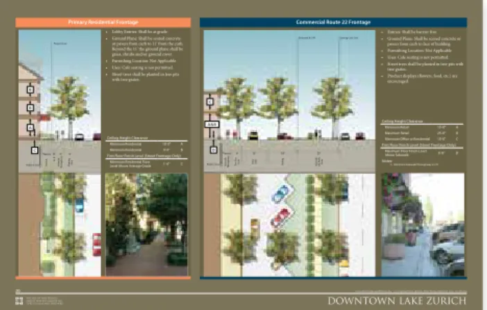
The regulations of most form-based codes are assigned by zoning district based upon classifications such as transect level, building type, or street type. At this stage, the code team will usually begin to define and illustrate the main characteristics of each district. The team will also begin to determine which details and elements belong in each district, such as what types of uses, buildings, frontages, thoroughfares, or civic spaces are allowed. A summary of this information is often paired with a written vision description and illustration of the district on a single page or two, which may be presented to the public as a poster for feedback and eventually serve as the main explanation of the district in the final form-based code document.
The Importance of the
Kick-Off Meeting
The kickoff meeting sets the tone for the creation of the community vision that will guide the form-based code. It’s a collaborative effort that requires the input of a variety of
stakeholders in the community (including the general public),
along with key professionals necessary to complement the knowledge base and skill set within the community. A form-based code is a legal document that inherently affects and will need to be approved by the community, and an effective kickoff meeting is vital to its success.
Oceanfront Resort District Form-Based Code Virginia Beach, Virginia
9 10 J U LY 2 012 BOARDWALK FRONTAGE
The Boardwalk is one of the most memorable places in Virginia Beach. Cyclists, beachgoers, visitors, and residents intermix with cafes and clubs that address out onto the ground floors of the hotels that rise above. Hotels have a maximum base height of 75 feet with towers as high as 200 feet. The Boardwalk is made accessible by regular intersections with Beach Streets.
SHOPPING FRONTAGES
Premier retail addresses within the Oceanfront Resort Area. Shopfronts, outdoor cafe seating, and other commercial uses front wide sidewalks and slower-moving traffic. Residential, office and hotel uses are typically located above the shops and restaurant uses. Streets include 17th, 19th, 31st, and Atlantic Avenue.
GATEWAY FRONTAGES
Primary routes to, through, and from the Oceanfront Resort Area. While these routes typically carry a higher volume of traffic, they still offer ample accommodations for the pedestrian. Parking and service is also accessed primarily from Gateway streets. Pacific Avenue is an example of a Gateway street.
BEACH FRONTAGES
Ways in which residents and visitors access the Boardwalk. Beach streets have clear visual and physical access to the Boardwalk and are lined with a mix of residential front doors and lobbies alongside outdoor dining and small retail establishments.
Frontage types, Oceanfront Resort District Form-Based Code (2012), City of Virginia Beach, Virginia. Credit: Urban Design Associates.