TOPOGRAPHIC SURVEYS TO IMPROVE THE INFRASTRUCTURE
FOR ROAD TRANSPORT
CĂLINA JENICA, CĂLINA A., MILUȚ M. University of Craiova, Faculty of Agriculture
Keywords: surveying, road section, longitudinal profile, modernization
ABSTRACT
The paper reveals the topography contribution to the rehabilitation and modernization of infrastructure for road transport. Specifically, the surveying contribution in this case consisted of: bringing in the work area of new points needed to trace and for detail surveying; the processing of data gathered from the field resulted a significant amount of information with topo-cadastral interest; graphic representation of all elements measured and processed according to the needs and desired aspects to be highlighted.
INTRODUCTION
Carrying out field studies involves data collection, processing and representation of plans and maps of all the planimetric and levelling details, also the use of topographic equipment and methods of calculation and graphical reporting, for which is necessary to know the theoretical and practical notions of almost all technical areas (Calina, 2010; Calina, 2015; Păunescu, 2001).
The roads are part of the the national transport system and are terrestrial communication paths specially built for vehicles and pedestrians. Are part of the roads: bridges, viaducts, passages, tunnels, construction of defense, sidewalks, bike lanes, parking, traffic signs and other facilities for traffic safety, land forming part of the road less protection zones. Road Administration aims the design, construction, rehabilitation, modernization, maintenance and operation of the roads.
Topographic survey is an important step in the rehabilitation and upgrading of transport infrastructure (Calina, 2012, Miluț, 2014). Digital topographic plan represents the technical basis for the realization of the Road Informational System. Worldwide and Romania, process of automation for topographic works is continuous, both in the equipment, and technologies of collection and processing of data (in some cases directly on the ground) and reporting plans using specialized software for certain applications, leading to true automated production lines (Călina, 2014a; Călina, 2014b;Tămâioagă, 2007).
Analele Universităţii din Craiova, seria Agricultură – Montanologie – Cadastru (Annals of the University of Craiova - Agriculture, Montanology, Cadastre Series)Vol. XLV 2015
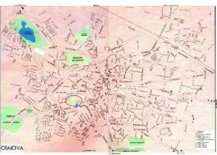
Figure. 1. Road network
MATERIALS AND METHODS
The purpose of the work was planimetrical and levelling survey of Nicolae Titulescu Boulevard - Calea Severinului km 0+000 - km 1+440, over a length of 1430 m. Nicolae Titulescu Boulevard is located between major intersections in Craiova and start from the intersection of Stefan cel Mare, Calea Unirii and Calea Bucureşti to the intersection Paşcani, Toporasi and Maria Tanase. The location of work fits functionally and urbanistic in the area which includes construction with complex functions: residential (apartment H1, H2, H3, G1, G2, I1, I2, I3, B1, B2, B3, 7, 9, A1, 4, 23, 20 etc.), public interest (Court of Appeal Craiova, Philanthropy Hospital, Church) and general interest (Union Complex, restaurants, shops, etc.). Surveying was executed in Stereo'70 projection system and the quota system Black Sea 1975, using as support network new points determined with the help of modern equipment such as: Leica TC 407 total station and Leica Sprinter 150M digital level.
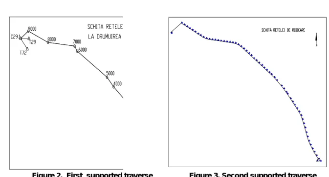
In the field were executed two supported traverses:
First supported traverse was performed on a length of 1430 m (Figure 2, Table 1) starting from C1.3 landmark with orientation visa on T1, going through station points 1000, 2000, 3000, 4000, 5000, 6000, 7000, 8000, 9000 closing on C29.1 landmark with orientation visas on T29 and T72;
The second supported traverse, starting from the absolute coordinates and altitude of C1.3 included 58 stations from 1 to 58 being closed on the coordinates and the absolute altitude of C29.1 point (Figure 3, Table 1).
Table 1. Old support points
Point no. Absolute coordinates Altitude Z
X Y
T1 313849.678 405068.436 0.000
T29 314878.633 402778.064 0.000
C1.3 314211.250 403924.607 93.278
N
Figure 2. First supported traverse Figure 3. Second supported traverse
Details existing along the boulevard and next to it were measured using radiation. Data processing was done in the specialized program CalTOP, to obtain altitude and absolute rectangular coordinates of measured points.
For all the planimetric and levelling details plotting at AutoCAD LT 2000 programme have been attached TopoLT and Topograph subprograms.
RESULTS AND DISCUSSION
Delimiting points of edge of the road, culverts and sidewalks (Table 2) were taken from: C1.3, 1000, 2000, 3000, 4000, 5000, 6000, 7000, 8000, 9000 and C29.1. Following the topographic work enforced in the area, resulted a level difference of 5.288 m, land altitude of starting point being 93.278 m and the final altitude was 87.998 m. Works for rehabilitation and modernization were conducted generally in the current footprint of the road, however there are road sections in which the works for rehabilitation are located outside the current footprint such as consolidation, some small corrections to the route to be removed blackheads. Road footprint is the land area occupied by the constructive elements of the road: the roadway, sidewalks, shoulders, ditches, culverts, embankments, retaining walls and artwork.
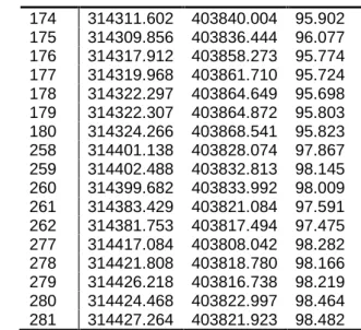
Table. 2 Coordinate inventory – partially
Projection System Stereo'70, Black Sea altitude system 1975
Point no.
Absolute coordinates Altitude Z
X Y
Analele Universităţii din Craiova, seria Agricultură – Montanologie – Cadastru (Annals of the University of Craiova - Agriculture, Montanology, Cadastre Series)Vol. XLV 2015
174 314311.602 403840.004 95.902 175 314309.856 403836.444 96.077 176 314317.912 403858.273 95.774 177 314319.968 403861.710 95.724 178 314322.297 403864.649 95.698 179 314322.307 403864.872 95.803 180 314324.266 403868.541 95.823 258 314401.138 403828.074 97.867 259 314402.488 403832.813 98.145 260 314399.682 403833.992 98.009 261 314383.429 403821.084 97.591 262 314381.753 403817.494 97.475 277 314417.084 403808.042 98.282 278 314421.808 403818.780 98.166 279 314426.218 403816.738 98.219 280 314424.468 403822.997 98.464 281 314427.264 403821.923 98.482
Longitudinal profile design was done taking into account the following principles: maximum allowable slope of 7%; the minimum design step 50 m; the compensation principle of earthwork volumes; principle of avoiding high embankments and deep cuts. In the longitudinal profile, the road follow STAS limitation there are no higher declivity than those admitted (Figure 4).
Figure 4. Longitudinal profile
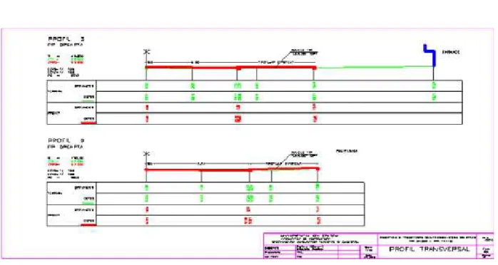
Figure 5. Crosswise profile
CONCLUSIONS
In the context of the work required to rehabilitate and modernize a road topographic contribution consisted of: identifying points of geodetic network and determination (in the work area ) of new points necessary to surveying details and tracing it; in the surveying stage was collected and recorded important information which by processing generated a considerable amount of topo-cadastral data; based on data analysis results we were chosen the most optimal solutions for consolidation, route adjustments, the design of the road structure, etc.
BIBLIOGRAPHY
1. Călina, A. et al.,2010-General and engineering topography, Ed. II.Sitech Publishing, Craiova, pp. 390;
2. Călina A. et al.,2014a -Engineering topography,Sitech Publishing, Craiova, pp.131.
3. Călina J., Călina A., Miluț M., 2012 - Use of GPS and classical technologies in the modernization works of DC 108 from the Bradesti locality, Dolj County, Annals of the University of Craiova - Agriculture,Montanology, Cadastre Series, Vol. XLII, 311-315 pp; 4. Călina J., Călina A., Băbucă N., 2014b - Study on the Implementation of GIS Databases in Achieving the General Urban Plan, 4th International Multidisciplinary Scientific GeoConference SGEM 2014, Conference Proceedings, Book 2, Vol. 1, 817-824 pp
5. Călina A., Călina J., Miluț M., 2015 - Study on Levelling Works Made for Drawing Tridimensional Models of Surface and Calculus of the Volume of Earthwork, Agriculture and Agricultural Science Procedia, Vol 6, 413 – 420 pp.
6. Miluț M.,Călina J., Călina A., Buzatu C.V., 2014-Aachievement of Network Support
for the Construction of a New Communication Way,Annals of the University of Craiova -Agriculture,Montanology, Cadastre Series, Vol.XLIV, 131-134 pp.