Reverse engineering in construction
Arayici, Y, Hamilton, A and Hunter, G
Title Reverse engineering in construction Authors Arayici, Y, Hamilton, A and Hunter, G
Type Conference or Workshop Item
URL This version is available at: http://usir.salford.ac.uk/11419/ Published Date 2003
USIR is a digital collection of the research output of the University of Salford. Where copyright permits, full text material held in the repository is made freely available online and can be read, downloaded and copied for noncommercial private study or research purposes. Please check the manuscript for any further copyright restrictions.
Reverse Engineering In Construction
Yusuf Arayici & Andy Hamilton, University of Salford Graham Hunter, Riegl UK Ltd
Abstract
Recently a great deal of research into construction IT has been completed, and this is ongoing to improve efficiency and quality in the construction sector. The new innovation of 3D laser scanning is aimed at being used to improve the efficiency and quality of construction projects, such as maintenance of buildings or group of buildings that are going to be renovated for new services.
The 3D laser scanner will be integrated with other VR tools such as GIS solutions and workbench for visualisation, analysis and interaction with a building VR model. An integration strategy is proposed for an Ordnance Survey map of the area and 3D model created by means of the laser scanner. The integrated model will then be transferred to the VR workbench in order to visualise, interact and analyse the interested buildings on purpose.
1. Introduction
Manchester is transforming itself from an industrial city to a post-industrial city. This regeneration is seen as a “Whole life cycle” process of construction, consisting of: Planning, Development, Operation, and Reuse. In order to enhance the implementation of the building solutions during the transformation of the city, the 3D laser scanning technology can be employed.
A key objective is to develop existing systems for use in urban regeneration and integrate them with the laser scanner to attain the benefits of working in a holistic environment. The new integrated system or “Virtual City” will facilitate a holistic approach to problems and thus have a much greater functionality than the individual sub systems [1]. The success of the Virtual City will be validated in terms of its effectiveness in its operation in conjunction with an assessment of the transformations made, within the project, to selected areas of Manchester.
2. 3D Laser Scanning
Systems that measure range from the time-of-flight of a laser pulse have been available for about 25 years, so this does not constitute new technology. However, the development of fast measurement (up to 6000 measurements per second) and a scanning mechanism (using rotating mirrors) has only occurred in the past 6 years or so. Packaging these components into a robust and reliable instrument has resulted in the innovation of a 3D laser scanner.
The scanner is targeted to the physical objects to be scanned and the laser beam is directed over the object in a closely spaced grid of points. By measuring the time of laser flight, which is the time of travel of the laser from the scanner to the physical objects and back to the scanner, the scanner determines the position in three-dimensional space of each scanned point on the object. The result is a “cloud of points” thousands of points in 3-dimensional space that are a dimensionally accurate representation of the existing object [2]. This information can then be converted in a 3D CAD model that can be manipulated using CAD software, and to which the design of new equipment can be added.
The idea of reverse engineering is rooted in a concept that is mainly dominated in system development by UML (Unified Modelling Language). To be precise, the system developers model the system based on the software specifications derived from the elicited user requirements. According to the developed system model, they do coding and develop the early prototypes. However, some UML tools generate program codes based on the determined model. That enables the developer to compare his own original code with the generated codes. This process also works the other way around; the same UML tools can generate the system model based on the codes written by the developers, which helps to benchmark the original system model with the generated one. Consequently, the developers undertake the right actions to optimise the system structure.
In the same manner, the laser scanner can provide reverse engineering in construction for the reuse of the existing facilities. Producing building design and CAD models and VR (Virtual Reality) models from an existing facility or groups of facilities, by means of the laser scanner, will facilitate an analysis of the latest conditions of the buildings taking into account the original drawings of the same buildings, if they still exist. Consequently, it facilitates “virtual refurbishment” of the buildings and allows the existing structure and proposed new services to be seen in an effective manner. Furthermore, the innovation of the laser scanner is also significant as it solves the most difficult problem that has always been associated with design and construction at an existing facility: how to accurately interface with the existing facility and avoid interferences during construction [3]. This problem is almost exacerbated by the fact that drawings for the existing facility are not completely accurate, if they exist at all.
shut down to permit construction to proceed, the owner will forego income from operating the facility for a longer time. On a large project, the costs incurred due to these types of problems can be very large.
3. Features of the 3D Laser Scanner and Software
The University of Salford make use of a Riegl LMS-Z210 3D laser scanner for construction research with PolyWorks software for processing the point data into a 3D model. The LMS-Z210 3D imaging sensor is a rugged and fully portable sensor for the rapid acquisition of high-quality three-dimensional images even under highly demanding environmental conditions. The scanner provides a combination of wide field-of-view, high accuracy, and fast data acquisition. The scanner in connected to a 12V battery and a ruggedised laptop.
The high-speed scanner has the following specifications:
o Maximum measurement range = 300 m (in typical conditions)
o Minimum measurement range = 2 m
o Measurement accuracy = typical +/- 25 mm
o Measurement resolution = 25 mm
o Beam divergence = approx. 3 mrad (i.e. 30cm beam width per 100m range)
o Field of view = 80° vertical angle, 333° horizontal angle
o Scanning rate = 6000 points per second
o Class I eye-safe laser
During data acquisition, the 3D-RiSCAN software is used. It allows the operator to perform a large number of tasks including sensor configuration, data acquisition, data visualization, data manipulation, and data archiving. Numerous export functions allow the scanned data to passed to post-processing data packages for, e.g., feature extraction or volume estimation.
A field methodology has been developed to rapidly capture data for a building survey. For each scanner position, first a scan of the full field of view (333° horizontally) is made to aid merging of data from subsequent scan positions and to aid the definition of detailed scans. This scan takes about 4 minutes. Next, one or more detailed scans are made with a finer resolution of the area of interest (typically the building). This scan typically takes 15 minutes depending on resolution and field of view. This methodology is being extended to incorporate GPS positioning of the scanner.
Once back in the office, PolyWorks software (produced by Innovmetric Software Inc.) provides comprehensive set of tools for quickly processing 3D scanned data [4]. This software has traditionally been used in the manufacturing industries with very short range scanners, but the advent of longer range laser scanners, it has seen widespread use in surveying and architecture, especially within North America. The software can handle many millions of data points while still retaining the ability to model very fine details very accurately.
comparison rather than a few observations that would be made in a conventional surveying scenario.
Next, the 3D mesh model (sometimes termed a wireframe) is created. This 3D mesh uses all the measured data points without applying any dangerous point sampling techniques. In its approach, it uses tolerance-based smoothing and tolerance-based adaptive meshing which provide a robust industrial strength process.
The 3D model can then be viewed, analysed and edited as necessary. It is also possible to use an intelligent simplification algorithm on the model to reduce the number of triangle vertices while retaining as much information as possible (especially on edges).
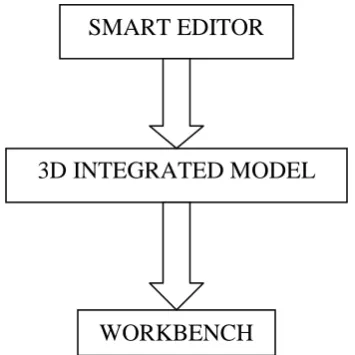
4. Integration Approach
The integration will be achieved in a number of stages. The initial stage of the integration, shown in Figure 1, combines four different components that are Ordnance Survey digital map data, 2.5D GIS model, Workbench and laser scanner data. However, the focus of this paper is the laser scanner in the integration strategy; the other components are not explained in detail in this paper.
The scanned raw data and OS digital map data are imported to Polyworks software, where tie points are determined and selected in both scanned data and OS data. Based on these tie points, both data types are overlaid. The integrated data is exported from Polyworks and imported to Multigen in order to complete the successive integration of 2.5D GIS data before transferring the whole integrated data into the VR Workbench, where the users can visualise and interact with the integrated 3D model for reverse engineering goals.
The above integration is utilised in the planning of built environments, which is both an analytic and visual process. The integrated model will be deployed in the planning of a regeneration area of Manchester.
OS MASTER
MAP DATA
SCANNED DATA WITH LASER
SCANNER
POLYWORKS SOFTWARE
MULTIGEN CREATOR 2.5D GIS URBAN
Figure 1 - The integration process of Polyworks, VR model, 2.5D GIS and Workbench
5. Expected Gains and Benefits
The proposed benefits are classified into two groups. Firstly, the laser scanning system reduces accidents associated with engineering and construction. Areas of a plant that would require scaffolding or other means of temporary access for traditional as-built methods (with resultant fall potential) can be as-built from the ground or permanent walkways using the laser scanning system. Areas that would place surveyors using conventional techniques in danger (e.g. along active highways) can be avoided. It will reduce costly construction errors and delays by providing highly complete, accurate and timely 3D geometry measurements and models of existing structures and sites. Added to these, it allows as-built records and surveys for complex or difficult to access areas and provides detailed as-built and topographic surveys to obtaining immediate, highly accurate profiles and volumes. Furthermore, the system can be used indoors or outdoors under any lighting conditions.
Secondly, it can provide an accurate city model, which can be visualised and interacted with on a Workbench. This will allow urban and environmental analysis of the buildings and surrounding the buildings. Consequently, the complex city problems such as intangible economic, social, and environmental factors [5] can be considered on the model.
5. Conclusions
This paper outlines the potential for use of the innovation of the 3D laser scanner within the construction industry for reverse engineering. This shows particular promise in areas of urban regeneration as often found in cities such as Manchester.
Reference:
[1] Hamilton, A., Trodd, N., Zhang, H., Fernando, T., Watson, K., (2001) Learning through Visual Systems to Enhance the Urban Planning Process, Journal of Environment and Planning B: Planning and Design 28(6) 833-845 Pion Ltd. London
SMART EDITOR
3D INTEGRATED MODEL
[2] Schofield, W., 2001, Engineering Surveying 5th Edition: Theory and Examination Problems for Students, ISBN 07506 4987 9
[3] Construction Innovation Forum 2001, Laser Scanner as built systems, 2001 Nova
award Nominati
[4] Polyworks user guide