Accident Analysis System by Integration of Spatial Data
Mining with GIS Web Services
Dipali B. Gaikwad, Yogesh W. Wanjari and Karbhari. V. Kale
Dept. Of CS and ITDr. Babasaheb Ambedkar Marathwada University Aurangabad (M.H.) India
ABSTRACT
The world is growing closer due to communication facilities. But this is also having an adverse effect on social, economic growth of any developing country. If we observe safety risks like fire, crime and accidents, Accidents are having high probabilities along with moderate impact. so we come to know accidents must be pay high attention.( wrf: INDIA survey report 2012). It has been estimated that over millions of persons die and half to this number are injured every single year in road accidents throughout the world causing around 1% of annual gross national product (GNP) resources of the developing countries. The main aim of transportation is handling the mobility with safety measures. Most of the time, due to lack of knowledge of place the injured person is unable to report the accident. Even if in many cases the persons are dying just because of lack of proper help. There are various technologies & researches which are focusing on the emergency services for providing help on accidental spots. GIS Web services are used to provide routing information to the healthcare facilities but this will not be working in the severe cases. In our approach we will create a SMS alert system for government authorities so they can come to know the accident has happened and reach on the spot for further investigation. This includes two emergency personals like police and healthcare facilities supporting mobile environment. This can be accessed on any GPRS enabled mobile device. The system can be useful for any common man for information of optimized routes to nearby healthcare facilities in a user friendly GUI from current location. This will also helpful for traffic officer for decision making &reporting of an accident. This data repository will help to the extraction of rules from pattern observed in accidents related to spatial characteristics with help of geo spatial data mining. This will be guidance to government authorities involved in road planning.
Keywords
safety risks, gross national product (GNP), emergency services, GIS Web services, SMS alert system, GPRS, Optimal routes, user friendly GUI, spatial data mining, road planning
1.
INTRODUCTION
The use of technology is rapidly increasing day by day! The transportation system has becoming a milestone in development of any developing country which focuses on economic growth of the nation. But day by day accidents are becoming hazard to this. These become disaster to the safety measures of transportation system and bring an adverse factor in routine life. The global accident statics indicate that the accidental rates per licence vehicle are very high in developing countries. Even more road accidents have been shown to cost around 1% of annual gross national product (GNP) resources of the developing countries, which they can ill-afford to lose[1].Hence there is a need to reduce this rate and provide
decision making & analysis of accidents. So the government authorities can provide countermeasures for prevention and avoidance of accidents. This will further help the authorities in roadways planning for further investigation. We can integrate data mining with web services for a wider access to provide the emergency services to the needy one. The main objective of this paper is to reduce the time required to report an accident and to determine its location more precisely. This will reduce the time required for the police and the emergency personnel to reach the accident location. In this paper, section I will focus on basic need of the proposed system, Section II have literature survey of previous work, section III specify the proposed system architecture, section IV focus on the experimental work done which include the technologies, algorithm used along with some results and section V specify the conclusions and future work to be done. Here we select the Aurangabad city(Maharashtra, INDIA) for our experimental work and also collect the required data from the same.
2. RELATED WORK
Every location can be expressed in the form of latitude and longitude and is associated with some spatial characteristics. Spatial data can be handled in various form i.e. real time or in a compiled form (reports). GIS can easily handle retrieve, manipulate, retrieve and analyse the spatial data. The hidden rules can be easily extracted from traffic data for decision making and improve the traffic safety conditions. The GIS technologies used for the ITS (Intelligent Transportation System) have been widely studied by many investigators in recent years. GIS-T (GIS for Transportation) is also increasing in demand [6]. GIS web services provide ITS applications such as basic Geo-processing tasks, such as address matching, map image display, and routing, without maintaining GIS tools or the associated geographical data [7]. Data Mining is the science of extracting useful and non-trivial information from the huge amounts of data that could be collected in many and diverse fields of science, business and engineering [8]. The GIS provides integration to data mining by adding the spatial dimension. The spatial data is available in latitude and longitude form. It is in large volume and in various formats. The interoperability of data is a big issue; the web service provides a convenient way to analyse and integrate data so there is a need of spatial data service to integrate the geospatial data rising from diverse locations. Web services technology has emerged as a corner-stone for interoperability solutions by providing the standard for communication between hybrid systems, and thus combining web service technology with Spatial Data Infrastructure and GIS technologies can help us solve this challenge [9]. Geospatial data mining can help in acquiring data from various sources and integrate them to easily identify the source of information. This integrates large volume of spatial data tin a tabular way like traditional way of data base management system. This also extracts knowledge and hidden rules for prediction of some patterns. Web Service is a kind of distributed computing technique based on object/component model. It is a self-contained, self-described and modularized application program. This application program can be published, located and called dynamically through Web. As soon as one Web Service is being configured, other application program, including other Web Service can discover and call this Web Service. Web Service can be considered as an extension of component model over the Internet because Web Service is a logical application unit that can be called over the Internet. It can access share and process geographical information. The Two important emergency
association rule mining for the spatial distribution features of traffic accidents. Here, we are using WEKA an open source data mining software with various types of classifiers, clusters. Again we are implementing WEKA for finding out some association rules so it will be helpful for decision making to traffic officers. The process starts by selecting the target data set, transforming it to the required format using data mining software (optional stage),performing data mining to extract the structure, and finally, interpreting and assessing the discovered structure[new]Firstly with GIS query we have to collect the required accidental data process data for missing values or for data conversion. Then we can apply association rule mining which extract rules in simple format. This will identify some patterns in accident which will help analysis of accidents in a detail way. We have to integrate the basic map with geocoded data with data storage. This will create a public data repository. Less work has done with temporal data. We Here, we have tried to bind user & government authorities in a common framework to reduce the gap of communication. This will reduce the time to report an accident too. Again the use of Harvesine algorithm for distance calculation will increase the accuracy. The same system can be useful for common man for routing information as well as for government authorities for reporting an accident and analysis of accidental data for prevention and avoidance of accidents.
3. SYSTEM OVERVIEW
The development of the system is divided into development of submodules like application server, GIS Server and Database server along with a user friendly GUI.
3.1 System Architecture
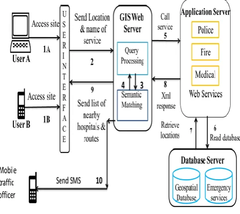
The system architecture is as shown in fig.1.The system is designed by integrating Ajax and web services with geospatial data mining keeping all technologies in their original form. The web services fetch the required data by data mining and utilize the map beyond traditional concept to show the dynamic routes between places. In this approach we have used different technologies like Ajax, PHP, MySQL. The harvesine formula is used calculate the distance between source and destination (source: current location of user and Destination: Health care facility) referred in the form of latitude and longitude. WEKA, open source data mining software is used for spatial data mining. The system is designed in following integrated steps:
3.1.1. Design User Interface
In this step the client has to visiting URL of website. The user has to select his current location by dragging the pin and select the name of the appropriate service. In case if the user is unknown to current location, he can enter the name of the area only& the default landmark is considered for location identification.
3.1.2. Registration and Configuration of Map
The map is mainly used for geo-coding of location of incident with a red markingpin. After processing it is capable to show the routing information to the user.3.1.3. Build GIS Web Server
[image:3.595.317.559.124.340.2]The Ajax will be helpful for loading and reloading of the map without refresh. The web services are registered by using UDDI and WSDL. Here we are using soap libraries with PHP.
Fig. 1 System Architecture
3.1.4. Preparation of WFS and WMS Request
(Transaction and Map Request)
The WMS (Web Map service) and WFS(Web Feature Service)is used to locate the point data and line data in the map
.
3.1.5. Build Application Server
This server act as a proxy server. A GIS service requester sends a request to the provider based on the WSDL of the chosen GIS web service. The Query optimizer resolves the request and forwards it to the semantic match maker for identifying the matched result. This step will perform semantic matching for looking up the appropriate service registered in the web server. It will receive GIS service request. After receiving the geographic information, the web server fetches data from database as per the requested service and perform routing with parameters like current location and fetched data. This will calculate the optimized route and the requester can display the GIS service result and then returns geographic information as a GIS service response to the GIS service requester.
3.1.6. Build Databases Server
After collceting the information about heathcare ,policeand fire station,create a database server consisting of a database having tabular data relative to healthcare,policeand fire stations.Here we are using MySQL for data storage.The tabular data as listed in table I,II and III is stored.This will create a data repository for government authorities.
3.1.7. Testing and Prototype with WFS and WMS
Request
3.2 Technologies Used
In this paper we used the following technologies for the developing emergency services. All the technologies work in their original form with an integrated way. The server is designed with soap libraries & PHP server side scripting. The Database server is implemented by MySQL.
3.2.1. GIS web services
OGC (Open Geographical Consortium) recommendation [16] in GIS web service includes three fundamental elements known as Web Map Service (WMS) for creation of map application visualized by the web browser. Web Feature Service (WFS) is for client to make web based access to the geo data in the form of GML (Geographical Mark-up Language). Web Feature Service Interface Standard (WFS) provides an interface which can help to create, update or delete features on map. Web Map Service Interface Standard (WMS) defines the geographic layer(s) and area of interest to be processed.[14,16].This will open a map in an image format like png or jpeg.
The main challenges of geospatial [14] data are Geospatial data are in bulk in size.
Loading and reloading of the data and map into the client is complex.
Geospatial data are highly heterogeneous.
The geospatial data can be collected from diverse locations. GIS Web services are stand alone and heavily loaded, so the use of AJAX technology can be integrated with GIS web services.
3.2.2. Geospatial Data Mining
The location on the map is retrieved in the form of latitude and longitude. With geocoding we can easily identify the location and its address. The geospatial data is large and available in the heterogeneous format. The data can be stored in a database and processed for the various applications. The data mining will
calculate hidden rules for improving safety conditions &decision analysis by traffic police department [15][16].
Weka is open source data mining software. We can mine data for our analysis with some required steps like cleaning & pre-processing data.
Table1: Health Care Service Information
Sr. No. Field Description
1 ID Unique id for each hospital
2 Name Name of the hospital
3 Type Type of hospital
4 Address Address of the hospital
5 Landmark Used to identify the hospital
6 Area Major area covered
7 Pin Pin code
8 Phone no For ambulance service
Table 2: Police Station Service Information
Sr.No. Field Description
1 ID Unique id for each
police station 2 Station
Name Name of Police Station 3 Address Address of Police
Station 4 Landmark Used to identify the
hospital 5 Area Major area covered
6 Pin Pin code
7 Phone no For FIR service
a. Retrieving the data from databases
b. Selecting the appropriate subset to work with:
Here we can select the number of attributes. As our database contain 13 attributes. Out of this Sr.no. does play any vital role in mining so we can omit this one.
c. Deciding upon the appropriate sampling strategy: Here we are going to perform some data conversion for selection of appropriate classifier or cluster type.
d. Cleaning the data and dealing with missing fields
e. Applying appropriate transformations, dimensionality reductions, and projections
f. Visualize this extracted information to decide whether it represent knowledge.
3.2.3. AJAX Technology
The AJAX technology can be worked easily on the client side and the page can be reloaded with the response without refresh. This can be easily incorporated with GIS web services and give a fast response. The Ajax can also be helpful for loading &reloading of map in case of inaccurate current position is selected.
The following technologies are incorporated:
HTML,HTML5or XHTML and CSS for presentation
The Document Object Model (DOM) for dynamic display and interaction with data
XML for the interchange of data, and XSLT for its manipulation
The XML Http Request object for asynchronous communication
JavaScript to bring these technologies together The JavaScript support for the well-known browsers so can be used with the AJAX technology.
Table 3: Collected Accidental Data
Sr.No. Field Description
1 ID Unique id for each
accident 2 Date Date of reported
accident
3 Time Time of reported
accident 4 Vehicle Type of vehicle involved
in reported accident 5 Season Season (wet or dry)
6 Type Severe(if
death),casual(if more injured persons) or
normal 7 Cause Cause for accident like
wrong turn, speed, traffic signal break, one way entry alcoholic driver etc.
8 Location Place of accident 9 Region Area f accident 10 Officer Government authority
for reporting accident 11 Mobile Mobile number of
officer 12 Injured No. of persons injured 13 Dead No. of persons dead if
any
3.2.4. Satellite Data
The area of particular interest can be extracted from satellite image. The road network can be easily drawn with line features and on selected area, we can add the buildings, hospitals as a point data as a layer on image. This converted map or shape file so can be accessed by a web service easily for performing geo-coding, generating driving directions, and obtaining elevation profiles [17].We can use Google maps or Bing maps, open street maps with registered APIs .Even we can add layers on this along with point data like locations or places. This will help in an easy way for routing information.
3.2.5. Distance Calculation
Instead of planet calculation for distance measurement we prefer sperihical measurements. In our approach we used the ‗Haversine‘ formula. It is used to calculate the great-circle distance between two points – that is, the shortest distance over the earth‘s surface [18]
Haversine formula:
a = sin²(Δφ/2) + cos φ1⋅ cos φ2⋅ sin²(Δλ/2) c = 2 ⋅ atan2( √a, √(1−a) )
d = R ⋅ c where
φ is latitude, λ is longitude, R is earth’s radius (mean radius = 6,371km);
note that angles need to be in radians to pass to trig functions! var R = 6371; // km
var φ1 = lat1.toRadians(); var φ2 = lat2.toRadians(); var Δφ = (lat2-lat1).toRadians(); var Δλ = (lon2-lon1).toRadians();
3.2.6. Parse XML Response
The XML response generated by the web service can be converted to text by parsing the XML document. Here we are using DOM parser for this. The root element of XML file is assigned as a root element of tree. The child elements of the XML file is assigned to the child element of the tree. The
DOM extension allows you to operate on XML documents through the DOM API with PHP 5.The DOM extension uses UTF-8 encoding. [19].
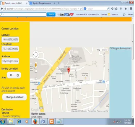
Fig. 2 Our System GUI
4. EXPERIMENTAL WORKS
4.1 Data Collection
The GPS data (geospatial locations) of police stations and the Healthcare units is collected by the field survey. The database of healthcare and police service consist the information in the tabular format which consist of various fields like name, address, area, pin and phone number .This database also consist of location information in the form of latitude& longitude(spatial data).As per the Table I and Table II the information has to be collected for the police and healthcare facilities. We have to collect this with the help of GPS pointing device through a filed survey for this.
4.2 Result Analysis
[image:5.595.315.544.122.337.2]Fig.3: Routes in detail with distance information
Table 4: Attribute wise Results of data
Sr. no.
Instance (Independent Attribute)
Correctly Classified (out of 148)
Incorrectly Classified (out of 148)
1 Type 146
(98.6486 %)
2 (1.3514 %)
2 Cause 32
(21.6216 %)
116 (78.3784 %)
3 Season 78 (52.7027 %)
70 (47.2973 %)
4 Region 146 (98.6486 %)
2 (1.3514 %)
5 Dead 136
(91.8919 %)
12 (8.1081 %)
6 Injured 83 (56.0811 %)
65 (43.9189 %)
7 Officer 147 (99.3243 %)
1 (0.6757 %)
8 Vehicles 72 (48.6486 %)
76 (51.3514 %)
9 Time 65
(43.9189 %)
83 (56.0811 %)
The optimized route is shown in text format as well as on the map by marking two locations one indicates current position & other indicate the healthcare facility. Here we are using the Web Map Service (WMS) for locating the position into the map and Web Feature Service (WFS) for displaying spatial information. The system work as follows:
The user selects the current position & the emergency service name & submits the request.
A service request is forwarded to GIS server. The Web server has registered web services. The request will get accessed as per the WSDL of the chosen GIS web service.
The Query optimizer resolves the request and forwards it to the semantic match maker for identifying the matched result. The semantic matching is get done with help of WSDL structure.
The provider receives the request and then returns geographic information & other details as a GIS service response to the requester. This is in the form of XML data. We need to fetch the required information from XML tag structure.
The DOM parser is used to fetch the content of XML.
After receiving the geographic information, the requester can display the GIS service result as shown in fig.3.in plain text format.
The distance calculation in the previous approach is calculated by Euler formula but this is a planar way. Calculate the between two coordinates will give you the straight line distance (as the arrow flies) with minimum accuracy along curves. The Haversine formula gives the shortest path on the Surface of the curved earth (spherical distance). Most geographic software applications need to compute the distance across the earth's surface, so the Haversine spherical trigonometry algorithms are used for better performance. For also we have utilized knowledge extraction rules by data mining on collected data. For data mining, we have used Weka, an java based open source software .We have done the classification ,clustering and find some associate rules for further investigation(13 attributes ,148 instances).The table shows the analysis of accidental data using J48 classifier. We can observe it gave good classification for the some attributes like type, season, region, officer, dead & injured vehicles attributes. So, we can guess the severity of accidents with the analysed data in detail. This analysed data is especially helpful for traffic officers or government authorities for decision making in traffic safety. As per details for regions, we can conclude the accident prone area. For example we have considered different causes for accidents& observe the output. The confusion matrix is as follows:
=== Confusion Matrix ===
[image:6.595.44.294.319.614.2]
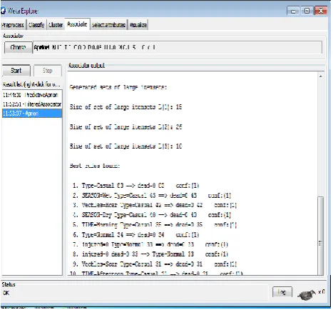
Fig.4: Result (Weka): Association Rule Mining
This will further focus the no of accidents may be happening because of traffic signals, wrong turn, one way & speed breakers. So we can take some special care & give some guidelines to follow the traffic rules. We can further read such type of reading for every attribute & try to find factors having effect on accidents. This will help the traffic officer to find out countermeasures for prevention &avoidance of accidents. This will again helpful for road designing & development authorities. We can dig out hidden rules for further help. These are shown in the form association. Some extracted rules using Apriori, predictive apriori which are shown in the fig 4. For example if vehicle is small car, type of accident is casual then we can predict that there may be injury case but certainly not the no.of persons are dead. In morning we have to take care as the numbers of normal accidents are increasing due to rush. Figure 4 for rules generated and Table 4 shows detailed analysis which can be helpful for decision making for traffic officers. Even if we can cluster the accidents as per\region, type of season, time for further investigation. This system can be helpful for both the common user as well as government authorities in an integrated way.
5. CONCLUSIONS
The accidents cause a great loss in a real life. It is essential to take a step forward! The government authorities require time to identify the location & reporting is thus prolonged. This project is based on the technological trend like RS &GIS. This will help for identification of a needy person & affected area & provide the optimized route to nearby services. Also this integrated system will act as SMS Alert system for government authorities & create a data repository available for public use for distance calculation. In our system we have used Harvesine formula which gives more accuracy. In future, we will use the mobile system to identify the current location of the user automatically & make the provision to send the image of accidental place in case of severe accident. We will try to convert this system into location based service which can automatically detect location with mobile device so that the current location of accident is less error prone. Even further we can make the provision of sending the picture of accident spot with inbuilt latitude and longitude information.
6. ACKNOWLEDGMENTS
Authors would like to acknowledge and extend our heartfelt gratitude to UGC who have funded for development of UGC SAP (II) DRS Phase-I F.No.-3-42/2009 to Department of Computer Science & IT, Dr. Babasaheb Ambedkar Marathwada University, Aurangabad.
7. REFERENCES
[1] DeeleshMandloi& Rajiv Gupta,‖Evaluation of accident black spots on roads using Geographical InformationSystems (GIS)‖, Map INDIA Conference,2003.
[2] Apparao. G, P. Mallikarjunareddy Dr. SSSV Gopala Raju,‖Identification Of Accident Black Spots For National Highway Using GIS‖, INTERNATIONAL JOURNAL OF
[3] SCIENTIFIC & TECHNOLOGY RESEARCH, VOLUME 2, ISSUE 2,2011.
[4] DrWen LongYUE ,Miao Feng ZHANG,‖THE USE OF GIS IN BLACK SPOT STUDIES‖, vol 4,No 5,October. 2001.
[5] HuayunChen,―Black Spot Determination of Traffic Accident Locations and Its Spatial Association Characteristic Analysis Based on GIS‖, Journal of Geographic Information System(Scintific Reserch)(JGIS),4, 608-617,2012.
[6] Xiaolin Lu,‖Develop Web GIS Based Intelligent Transportation Application Systems with Web Service Technology‖, IEEE,6 th International Conference on ITS Telecommunications Proceedings,2006.
[7] Eman El Amir, Prof. Osman Hegazy,Assoc. Prof. Mohamed NourEldien ,Assoc. Prof. Amr Ali, ‖Integrating Web Services With Geospatial Data Mining Disaster Management for Road Accidents‖, Geoinformatica - An International Journal (GIIJ), Volume (2) : Issue (1),2011.
[8] M. Hampe and S. Intas, ―EXTENSION OF THE OGC WEB FEATURE SERVICE STANDARD FOR MULTIPLE REPRESENTATION DATA,‖ Information Sciences, no. July,pp. 12-14, 2006.
[9] F, Alkhateeb, E. Al Maghayreh and M. T, S. Aljawarneh, ‖The Use of Location Based Services for Very Fast and Precise Accidents Reporting &locating‖ , International Conference on Intelligent Systems, Modelling and Simulation, 978-0-7695-3973-7/10,2010. [10]J. H. Schiller and A. Voisard, Eds., Location-Based
Services. Morgan Kaufmann, 2004.
[11] B. Rao and L. Minakakis, ―Evolution of mobile location based services,‖ Commun. ACM, vol. 46, no. 12, pp. 61– 65, December 2003.
[12]P. Bellavista, A. Küpper, and S. Helal, ―Location-based services: Back to the future,‖ IEEE Pervasive Computing, vol. 7, no. 2, pp. 85–89, 2008.
[13]Y. Chen, X. Chen, X. Ding, F. Rao, and D. Liu, ―Bluelocator: Enabling enterprise location-based services,‖ Mobile Data Management, IEEE International Conference on, vol. 0, p.167, 2002.
Computing, Volume : 10 , Issue:5 Sept.-Oct. 2006, PP : 13 – 15
[15]R. Jeberson Retna Raj, T. Sasipraba,‖Disaster Management System based on GIS Web Services‖,IEEE, 978-1-4244-9182-7/10,2010.
[16]Wang Jinlin, Chen Xi, Zhou Kefa, Wang Wei,Zhang Dan,‖Application of Spatial Data Mining in Accident Analysis System‖, International Workshop on Education Technology and Training &International Workshop on Geoscience and Remote, 978-0-7695-3563-0/08,2008
[17]OGC inhttp://www.opengeospatial.org/standards/is
[18]Harversine Algorithm viewd on : http://www.movable-type.co.uk.
[19]DOM parser viewed on :http://www.php.net/manual/en.
[20] http://en.wikipedia.org/wiki/Web_Feature_Service