www.nat-hazards-earth-syst-sci.net/12/3013/2012/ doi:10.5194/nhess-12-3013-2012
© Author(s) 2012. CC Attribution 3.0 License.
and Earth
System Sciences
Crossing the digital divide: an interoperable solution for sharing
time series and coverages in Earth sciences
F. R. Salas1, E. Boldrini2, D. R. Maidment1, S. Nativi2, and B. Domenico3 1Center for Research in Water Resources, University of Texas at Austin, Texas, USA
2Earth and Space Science Informatics Laboratory of the Institute of Atmospheric Pollution Research, Italian National Research Council, Rome, Italy
Correspondence to: F. R. Salas ([email protected])
Received: 1 April 2012 – Revised: 17 July 2012 – Accepted: 28 July 2012 – Published: 2 October 2012
Abstract. In a world driven by the Internet and the readily ac-cessible information it provides, there exists a high demand to easily discover and collect vast amounts of data available over several scientific domains and numerous data types. To add to the complexity, data is not only available through a plethora of data sources within disparate systems but also represents differing scales of space and time. One clear di-vide that exists in the world of information science and tech-nology is the disjoint relationship between hydrologic and atmospheric science information. These worlds have long been split between observed time series at discrete geograph-ical features in hydrologic science and modeled or remotely sensed coverages or grids over continuous space and time do-mains in atmospheric science. As more information becomes widely available through the Web, data are being served and published as Web services using standardized implementa-tions and encodings. This paper illustrates a framework that utilizes Sensor Observation Services, Web Feature Services, Web Coverage Services, Catalog Services for the Web and GI-cat Services to index and discover data offered through different classes of information. This services infrastructure supports multiple servers of time series and gridded informa-tion, which can be searched through multiple portals, using a common set of time, space and concept query filters.
1 Introduction
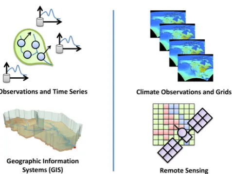
Data interoperability in the study of Earth science is es-sential to performing interdisciplinary scale multi-dimensional analysis (e.g. hydrologic impacts of global warming, regional urbanization, global population growth
etc.) that tries to explain and predict the complex processes that make up the Earth system as a whole. These studies re-quire researchers to collect and synthesize large quantities of data stored in various formats by numerous organizations, agencies and research groups that represent a diverse array of scientific communities. For centuries, scientists in all areas of research have viewed data as a means for solving very spe-cialized problems and have locked their results away. How-ever, the emergence of the Internet supports transparency in science through the sharing of information of multiple types (e.g. sensors, observations, models, etc.). Users should have the ability to seamlessly search and discover data published by researchers across multiple disciplines and then readily access that information through a standard process.
Fig. 1. The digital divide between hydrologic and atmospheric
sci-ence data.
and relational databases, while atmospheric data is stored in large binary files in specialized formats as multi-dimensional arrays (e.g. netCDF, GRIB, etc.)
Three of the most prominent leaders in the sharing of hydrologic and atmospheric science data are the Consor-tium of Universities for the Advancement of Hydrologic Science Inc. (CUAHSI), the Unidata Program Center, and the Earth and Space Science Informatics Laboratory (ESSI-Lab) of the Italian National Research Council. Each group has been developing cyberinfrastructure to share data effi-ciently via the Web using standard Web services. CUAHSI has primarily focused on the distribution of time series ac-quisitions from in-situ gages, while Unidata and ESSI-Lab have focused on the distribution of atmospheric science grids and coverages. As of 2011, the CUAHSI Hydrologic In-formation System (CUAHSI-HIS) has compiled the largest catalog of hydrologic time series in the world (CUAHSI, 2012). These catalog records are stored on a collection of CUAHSI-HIS servers and databases and are indexed at the San Diego Super Computing Center (SDSC) in a catalog called HIS Central (Maidment, 2009). By indexing records available by the United States Geological Survey (USGS), National Oceanic and Atmospheric Administration (NOAA), Environmental Protection Agency (EPA) and other agen-cies and academic institutions, CUAHSI-HIS has cataloged approximately 23 million time series accounting for more than five billion data values (Tarboton et al., 2010). Sim-ilarly, Unidata has systematically indexed various models and remote sensing and satellite coverages from the tional Centers for Environmental Prediction (NCEP), Na-tional Aeronautics and Space Administration (NASA), etc. on Thematic Realtime Environmental Distributed Data Ser-vices (THREDDS) servers (Nativi et al., 2006; Unidata, 2012). While ESSI-Lab does not provide tools to physi-cally store gridded data, ESSI-Lab instead provides a broker
catalog service, GI-cat, which seamlessly integrates data stored across disparate catalog systems (ESSI-Lab, 2012). Although CUAHSI, Unidata and ESSI-Lab have developed successful information systems that connect data providers and users, each system was initially designed to respectively manage and share either time series or grids, not both to-gether.
When sharing information across scientific communities, it becomes important to define a standard framework through which large quantities of multidisciplinary information can be shared, discovered and accessed. In 2010, CUAHSI-HIS demonstrated that hydrologic time series can systematically be shared and discovered across the Web using standard-ized Open Geospatial Consortium (OGC) Web services as opposed to its own customized WaterOneFlow Web ser-vices (Bermudez and Arctur, 2011; Seppi, 2010). Likewise, Unidata and ESSI-Lab have demonstrated that OGC Web services can be used to share atmospheric grids and cover-ages. Since 2000, the OGC has been fostering collaboration amongst researchers in Earth sciences by building a standard operational platform using Web services through which data users can readily access and ingest large quantities of geospa-tial metadata and data (OGC, 2012). This is just one of the many examples where the world is building a Web services framework for computers to communicate in an ad hoc man-ner (Vector, 2012).
Utilizing a collection of OGC Web services, CUAHSI de-signed a “services stack framework” that shares catalog data, metadata and data with the user (Seppi, 2010). The services stack framework identifies three types of services as essen-tial to sharing water information across the Web: catalog vices, metadata services and data services. These three ser-vices work together to completely index, describe and pro-vide access to water information (e.g. time series). Catalog services provide users with an index of hydrologic metadata, metadata services identify collections of time series available over a domain of space and time, and data services provide the user with the raw data for a specified temporal period and spatial area. While this framework was originally de-signed to publish and distribute time series, it can be shown by implementing the OGC services infrastructure that this framework can be extended to include grids and coverages as well. While other interoperability studies have focused on implementing custom data streams (e.g. bridges, adaptors, etc.) between clients and server interfaces, this study will focus on a common data and metadata management model that leverages a suite of OGC standard Web services which can be applied to multiple scientific communities – in par-ticular hydrologic and atmospheric sciences. Furthermore, it will be demonstrated that the aforementioned data manage-ment model can be integrated within existing data discovery frameworks (e.g. portals, gateways, etc.) by leveraging me-diation and brokering services.
with spatial and temporal filters, semantic filters aid the user in the data discovery process by systematically retrieving the data that matches or is related to a concept defined by the user (i.e. search term). Within the CUAHSI-HIS, concepts and relationships between concepts, are methodically organized using the CUAHSI ontology which have been developed and optimized for hydrologic time series data (Whitenack, 2010). In contrast, the atmospheric science community has most commonly relied on the Climate and Forecast (CF) Meta-data Conventions to describe gridded Meta-data stored in netCDF files (Unidata, 2012). It is recognized that many semantic on-tologies exist and are not limited to the two presented above (Bermudez and Piasecki, 2006); however, in this paper we fo-cus on common search terms within the CUAHSI ontology and CF conventions.
This research demonstrates a collaborative effort between CUAHSI, Unidata and ESSI-Lab to provide a sound inter-operable framework that systematically allows users to dis-cover and access both hydrologic and atmospheric science data through a common interface that leverages standard Web services; clients that build upon this framework will be the focus of future work. In order to justify this claim, two in-teroperability experiments were conducted and implemented using a variety of tools, software and services. The first ex-periment utilizes the GeoPortal interface designed by the En-vironmental Systems Research Institute (ESRI), while the second utilizes a broker catalog service called GI-cat, de-signed by ESSI-Lab.
2 Background
2.1 Interoperability through network-based software architectures
The stateless Client–Server (C–S) is a commonly imple-mented architectural style in network-based systems and ap-plications. Within C–S, two types of components are present: clients and servers. Clients request services from servers via their interface while servers listen for requests based on the services they offer (Fielding, 2000). A Service-Oriented Ar-chitecture (SOA) is a set of principles and methodologies enabling software interoperability through a C–S architec-ture style. SOAs typically include a third component that allows clients to search through available services and their providers; this third component is implemented as a service registry (Oasis, 2006).
When building connection streams between C–S compo-nents, systems must conform to the interfaces provided by each. The connection streams are usually described in terms of message payload models, encodings, protocols, bindings, etc. Together, they define the mechanisms through which messages via the Web are exchanged and data carried in them decoded. Within the context of interoperability, con-nection streams between interfaces are a focal point of many
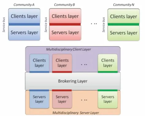
Fig. 2. Community Layered C–S architectures and the broker
archi-tecture for multi-disciplinary environments (Nativi et al., 2012).
standardization processes. The literature defines a collection of interface standards that characterize a network-based sys-tem as a “service bus”. A service bus can also be defined as the middleware glue between a client and service layer; a service bus enables communication within network-based systems (Ortiz, 2007; Schmidt et al., 2005).
In information science, communities, within their respec-tive scientific disciplines, utilize single or several service buses to enable domain application and build disciplinary data exchange infrastructure. Both CUAHSI and Unidata have each established a service bus within their respec-tive scientific communties, whereas ESSI-Lab has devel-oped a mediation approach to interconnect system compo-nents across scientific disciplines, as can be seen abstractly in Fig. 2.
There are several important aspects that are considered when working towards an interoperable data solution. As communities define sets of standards for their respective ser-vice bus(es), the following ideas are typically considered in the drafting process (Nativi et al., 2012; Ramamurthy, 2006):
– data and metadata models
– encoding formats
– controled vocabulary and ontologies
– service interfaces and binding protocols
– data policies
or across scientific disciplines is often tedious and can result in a high entry cost; either clients must implement interface adaptors or bridges or servers must publish data through multiple service buses. To overcome some of the difficulties associated with imposing a single service bus for a particular data stream, mediation layers have been created to integrate across different data models (Nativi et al., 2009). Mediation was first used to map from existing and well-adopted specifications to the mandated federal specifications by implementing the mediators approach described by Wiederhold (Wiederhold, 1992). This strategy has been proven successful in federating existing and legacy capacities, while at the same time avoiding high level entry costs associated with implementing difficult and heterogeneous standards.
The introduction of mediation components establishes a Layered C–S (LCS) architecture in which each layer pro-vides services to the layer above it and uses services from the layer below it (Garlan and Shaw, 1993). Some common LCS infrastructures include solutions that leverage proxy and gateway components. A gateway service publishes multiple interfaces, each taking requests from myriad clients and for-warding them (possibly after translation) to a single service component (realizing anMto one cardinality). A proxy ser-vice on the other hand appears as a single serser-vice to its clients, but is able to forward the incoming requests (with possible translation) to its “inner-layer” servers (realizing a one toN cardinality). Whereas proxies and gateways both limit their exposure to either a single client or server, a broker service reduces the interoperability burden on both the client and server. The middleware components within a brokering service mediate between multiple service providers and mul-tiple service consumers (realizing anMtoN cardinality). A broker can interconnect different service buses from different communities, mediating between their existing (and future) models and interface specifications. In addition, it works out all the necessary distribution and virtualization capabilities to lower the entry barriers for multidisciplinary applications, both for services and clients as seen in Fig. 2 (Nativi et al., 2011).
The following sections will expand upon both the CUAHSI and Unidata architectural frameworks so as to pro-vide a basis for the interoperable solutions presented in this study. As leading data publishers within their respective sci-entific communities, these two systems provide a relevant use case where two disparate systems encounter interoper-ability obstacles. Several studies focus on adaptors, bridges and gateway technologies to overcome interoperability issues (Alameh et al., 2006; Giuliani et al., 2011; McDonald et al., 2006; Padmanabhan et al., 2011) but few explore common data management models across scientific disciplines (Rui et al., 2011). This paper will demonstrate (1) how a com-mon data management framework can be built around exist-ing infrastructures by leveragexist-ing standard web services and
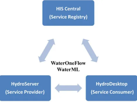
Fig. 3. Services-oriented architecture for CUAHSI-HIS.
(2) how this solution can be integrated with other scientific disciplines through a mediation approach.
2.2 The CUAHSI Hydrologic Information System
As part of the CUAHSI-HIS development, an SOA was iden-tified as one of the key components to building a sustain-able and relisustain-able system that supports the sharing of hy-drologic data (Tarboton et al., 2011). As with any other SOA, CUAHSI-HIS was built around two fundamental com-ponents: (1) service providers and (2) service consumers. Although service consumers directly connect to service providers to request and receive data, a third component, a service registry, is introduced to facilitate the discovery of different service providers (Tarboton et al., 2011); this can be done using various keywords, metadata and filters. As ser-vice providers introduce their serser-vices within CUAHSI-HIS, services are registered at the service registry. Service con-sumers can then search the registry to find available services of interest. Figure 3 outlines the SOA for CUAHSI-HIS.
The individual components of CUAHSI-HIS each serve an important role in the data discovery and fetching pro-cess. HydroServers function as the principal locations for storing large volumes of hydrologic data, specifically time series. Within the server itself, data and metadata are man-aged in a database and then exposed through a suite of Web services (e.g. a WaterOneFlow Web service) so that remote users can then access the data through the Web (Horsburgh et al., 2010).
Another component of CUAHSI-HIS is HIS Central or the hydrologic metadata catalog. HIS Central is the component of CUAHSI-HIS which facilitates the discovery of hydro-logic data that has already been published on HydroServers. Within CUAHSI-HIS, HydroServers are the primary reposi-tories for hydrologic data, while HIS Central is the primary repository for hydrologic data services (Maidment, 2009). HIS Central provides an interface where users can search reg-istered HydroServers by specifying keywords and metadata which describe the hydrologic data of interest (Tarboton et al., 2010). HIS Central is like a Google for discovering hy-drologic time series information. Data publishers can regis-ter their data on HIS Central and provide brief descriptions of the datasets they want to share. This is an important aspect of CUAHSI-HIS because it allows for data to be organized and discovered in an efficient, structured and methodical process. The third and final component of CUAHSI-HIS is Hy-droDesktop. HydroDesktop is the component of CUAHSI-HIS that allows for the harvesting of hydrologic informa-tion at the locality of one’s own computer or analytical sys-tem (Ames et al., 2010). HydroDesktop is a platform lo-cated on the user’s machine and communicates with both HydroServers and HIS Central (Tarboton et al., 2010). Users can directly download hydrologic information from Hy-droServers if they already know of their existence or can search HIS Central for data that they might not know about (Ames et al., 2010). Once the data of interest has been dis-covered, users can download the information onto their local databases. With the information readily and locally available, users can take data they have harvested and combine it with other data already available on their machine and use it to perform insightful analysis and/or modeling. HydroDesktop is intended to synthesize hydrologic information in an envi-ronment that supports both time series and geographic visu-alization (Maidment, 2009). With this unique structure, Hy-droDesktop provides a method for users to efficiently man-age and work with hydrologic information. Although Hy-droDesktop plays an important role in the CUAHSI-HIS SOA, this study will focus on the underlying services frame-work through which HydroDesktop can be modified to re-trieve and synthesize both hydrologic and atmospheric sci-ence information.
As of 2011, CUAHSI-HIS contains the biggest water data catalog in the world. With 66 public services registered at HIS Central, 5.1 billion data values measuring 18 000 vari-ables at 1.9 million sites are made accessible to the public
for quick and efficient use (Tarboton et al., 2010). Not only does CUAHSI-HIS allow data consumers to access small datasets used for research, it also allows data consumers to access large datasets published by federal agencies. The United States Geological Survey (USGS) and the Environ-mental Protection Agency (EPA) are both examples of fed-eral agencies distributing time series data through CUAHSI-HIS. Although CUAHSI-HIS has demonstrated a successful web services approach to managing and sharing hydrologic information, it has yet to cross the digital divide and provide access to the plethora of gridded information collected by those in the field of atmospheric sciences.
2.3 Unidata and Thematic Realtime Environmental Distributed Data Services
The Unidata project, developed within the University Cor-poration for Atmospheric Research (UCAR), has been stan-dardizing the manner in which atmospheric science informa-tion (e.g. satellite, radar, model outputs, lightning data etc.) is openly shared across the Web. Like CUAHSI-HIS within hydrologic sciences, Unidata has designed an SOA based ser-vice bus that enables users to efficiently publish, discover and access atmospheric science data through the Web, specif-ically grids and multi-dimensional arrays. Unidata has de-veloped three main tools to help facilitate this process: the Network Common Data Form (netCDF), the Thematic Real-time Environmental Distributed Data Services (THREDDS) (Domenico, 2002), and the Integrated Data Viewer (IDV). These three components work together in a form similar to CUAHSI-HIS: THREDDS servers manage, store and pub-lish gridded data in netCDF format via web services; Unidata builds a registry of THREDDS servers; and IDV discovers, synthesizes and accesses gridded data.
Within CUAHSI-HIS, WaterML was designed to facili-tate the exchange of time series data across the Web. As an analogy, netCDF is the WaterML of Unidata. NetCDF is a data model that incorporates a set of interfaces, libraries and standardized formats that support the creation, access and sharing of gridded scientific data (OGC, 2010). As part of this effort, a netCDF binary encoding as well as an XML realization called NcML have been defined (Nativi et al., 2005). Studies have shown that the array-oriented structure of netCDF files provides the most efficient form of storing and retrieving gridded time series (Doraiswamy et al., 1999). Moreover, netCDF allows data to be visualized using GIS software, which has become a leading technological and an-alytical platform through which interoperability studies are performed. The efficient structure of netCDF allows for ac-cess to small subsets of large multidimensional arrays (OGC, 2011).
allow data providers to publish and completely describe gridded data through the utility of standard Web services (Domenico et al., 2006). THREDDS servers act as the in-termediary between the data provider and data user by stan-dardizing the format in which gridded data is made accessi-ble regardless of the format the underlying data is stored in (Domenico et al., 2006). In this study, we focus on gridded data that is published as Web Coverage Services (WCS) be-cause of its standardization within the OGC infrastructure. A WCS (comparable to a WaterOneFlow web service) is a stan-dardized Web service that facilitates the exchange of cover-age data (e.g. netCDF, GRIB, HDF datasets) across the Web (OGC, 2008). Because THREDDS servers distribute gridded data using standardized Web service interfaces, THREDDS has become a well-used and robust tool for managing and distributing large quantities of gridded information.
The final component within the Unidata SOA is IDV. IDV is the HydroDesktop for discovering and accessing gridded data and metadata. IDV enables data consumers to search and retrieve gridded information stored on remote THREDDS servers (Meertens et al., 2006). Data consumers can search for gridded information by filtering on keywords and meta-data and then readily connect to the meta-data provider to access the dataset of interest. IDV primarily functions to connect the data user to the data provider and facilitate the manner in which gridded data is discovered, transmitted and retrieved.
Although slightly different in paradigm, Unidata and CUAHSI have both developed SOAs and unique service buses that focus on efficiently delivering scientific informa-tion from data providers to data consumers. CUAHSI-HIS manages and distributes hydrologic data stored as time se-ries, while Unidata manages and distributes atmospheric data stored as multidimensional arrays or grids. A framework which can tie together both the CUAHSI-HIS and Unidata systems will help promote interoperability among scientists. 2.4 Standardization process and initiatives in the
geospatial Web realm
In recent years, a plethora of initiatives linked to GeoIn-formatics have rapidly emerged. More than forty organiza-tions, agencies, initiatives and programs attended The Earth
& Space Science Informatics Summit, held in Rome in 2008.
This vast presence of multidisciplinary organizations en-forced the need to promote interoperability, communication and cooperation across scientific disciplines within the Earth sciences (Fox, 2008). Amongst the initiatives and organiza-tions that have committed to drafting guidelines and regu-lations supporting interoperability are the AGU ESSI group of interest, the EGU ESSI division, the OGC, the European directive INSPIRE, the Global Monitoring for Environment and Security (GMES) program, the ISO technical commit-tee 211 and the Group on Earth Observations (GEO). There are several other groups working on interoperability issues as well; however, many of them are focused on the underlying
technological aspects of interoperability (e.g. OASIS, IEEE, IETF, W3C).
Within the context of this study, the OGC provides the services infrastructure that enables a common interoperable data model that conforms to standards. The OGC is a con-sortium of industry leaders from government, private and re-search sectors around the world that develops international open standards and interoperable solutions that “geo-enable” the web (OGC, 2012). As part of this effort, the OGC devel-ops schemas and specifications for geospatial Web services. Some of these services include Sensor Observations Ser-vices (SOS), Web Feature SerSer-vices (WFS), Web Coverage Services (WCS) and Catalog Services for the Web (CSW) (OGC, 2005, 2007a, b, 2008). Respectively, each of these services focus on transmitting different types of geospatial information across the Web: observations data; geographic features, multidimensional arrays and grids; and geospatial metadata. In recent years, many governments and interna-tional agencies (i.e. GEO, Federal Geographic Data Commit-tee (FGDC), World Meteorological Organization (WMO), etc.) have endorsed several of the OGC’s Web service stan-dards (OGC, 2012). It is becoming apparent that standardized Web services are a common practice amongst data providers and consumers worldwide by providing the building blocks for not only e-infrastructure but also spatial data infrastruc-ture (Nebert, 2004).
3 Design concepts
Using the knowledge and experience gained by CUAHSI, Unidata and ESSI-Lab, we introduce the conceptual data model behind an interoperable solution that would allow users to readily access both hydrologic and atmospheric sci-ence data within a common interface. In the following sec-tions we introduce the individual components of this solution and describe their role in fostering interoperability.
3.1 Conceptual data object model
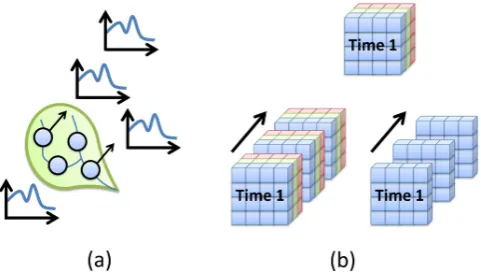
One of the main differences that inhibit the sharing of hy-drologic and atmospheric data is the conceptual model for which a data object in space and time is described. In hydro-logic science, there is one common approach to describing a time series object: a time series object is a variable measured at particular point in space over a period of time. In atmo-spheric science, this is not the case. There are multiple ap-proaches to describing a collection of grids as a single data object: a collection of grids can measure myriad variables over a period of time, myriad variables at a single instance in time, or one variable over a period of time. See Fig. 4.
Fig. 4. Traditional data storage for (a) time series and (b) grids.
variable domain (Maidment, 2002). The data cube states that a particular data value measures a single variable at a loca-tion in space and posiloca-tion in time. If one were to extend this model to encompass many values over a particular domain, one can then describe a set of values instead of just a single value. This is what CUAHSI-HIS has done to describe time series within its SOA. CUAHSI-HIS conceptually describes a time series object as a set of values, sampled in time, de-scribing a variable at a specific site within a given network provided by a data source (Maidment, 2009). Although this is the conceptual model, this does not limit a time series ob-ject from having additional metadata associated with it. In fact, there have been numerous studies that focus on meta-data within the field of hydrology (Horsburgh et al., 2009; Piasecki and Beran, 2009; Whitenack et al., 2010).
Similarly, one can think of a data object as describing a collection of time varying grids. The OGC defines a cov-erage as a “space-time varying phenomenon” or more suc-cinctly put, a collection of grids describing a variable(s) over a period of time within a dataset provided by a data source. With respect to time series, one might think of this as a spa-tially continuous 2-D or 3-D coverage as opposed to a dis-crete 1-D coverage (i.e. time series); 3-D refers to a cover-age containing multiple variables. In this study, we extend the CUAHSI-HIS model and describe gridded data objects as 2-D coverages to facilitate the discovery of data; this will be expounded upon in the following sections. Although we choose to describe gridded data as a set of 2-D coverages, we recognize that gridded data can be stored on servers as either 2-D or 3-D data objects; it is possible to access subsets of 3-D coverages by leveraging OGC WCS. As with time se-ries, additional metadata can be attached to a 2-D coverage to completely describe the object of interest. Figure 5 demon-strates the data object model for both a 1-D time series and 2-D coverage.
This conceptual model is the basis for the proceeding work and interoperability experiments. It is the conceptual frame-work for organizing data objects which allows data to be managed and published in a way that users can discover and
Fig. 5. Conceptual data object model for a (a) 1-D time series and (b) 2-D coverage.
access both hydrologic and atmospheric science information within a common interface. In many cases gridded data is not organized in the aforementioned manner, thus providing challenges in the data discovery process. Grids routinely pub-lished on THREDDS servers in real or near real-time often describe a collection of variables for a single (not multiple) time step. In these situations, large quantities of disjointed grid files are generated and hinder the ability for users to ac-cess temporal subsets of large datasets.
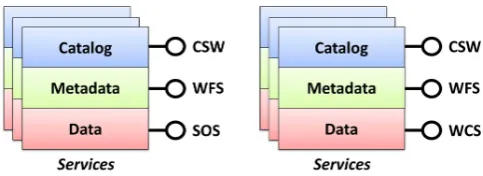
3.2 CUAHSI-HIS services stack
Fig. 6. CUAHSI-HIS services stack framework for time series and
coverages.
3.2.1 Data services
Data services are at the bottom of the services stack frame-work and are responsible for providing users with the data sought after. These services follow the Sensor Observation Service (SOS) and Web Coverage Service (WCS) specifi-cations outlined by the OGC. For hydrologic information, time series data is obtained through a SOS implementation encoded in WaterML 2.0 (Seppi, 2010; OGC, 2012, 2007b). Similarly, for atmospheric science information, coverages can be obtained through a WCS implementation as a netCDF file (Nativi and Domenico, 2009). Each service allows users to specify spatial, temporal and semantic filters to obtain subsets of the larger datasets supplied by the data service. Below is a sample SOS and WCS request:
http://129.116.104.174:8080/KiWIS? service=SOS&
request=GetObservation& featureOfInterest=30463& ObservedProperty=Q&
eventtime=2012-01-00T00:00/2012-03-01T00:00& responseFormat=text/xml;subtype=WML2
http://nomads.ncdc.noaa.gov/thredd/wcs/aggs/narrmonA? service=WCS&
request=GetCoverage&
bbox=-145.54,0.7532,-2.3244,46.5161& coverage=Total precipitation&
time=1979-01-01T00:00/1986-01-01T00:00& format=NetCDF3
3.2.2 Metadata services
Metadata is an essential component of the data sharing pro-cess. Not only does it facilitate the search and discovery of information within one’s own research community but also helps foster interoperability between research commu-nities. Metadata is used to describe a set of data that share a common ground to others who are not directly familiar with the information. With so many different research fields in existence, finding common approaches and structures for
Fig. 7. CUAHSI-HIS metadata services for time series and
cover-ages.
developing metadata is not yet clear. However, the metadata issue is very well documented and has led many scientific communities to adopt metadata standards created by the In-ternational Organization for Standardization (ISO). Specifi-cally, the ISO-19115 standard provides a manner in which geographic metadata can be published across Web based in-formation systems (Inspire, 2010).
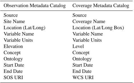
Table 1. Condensed CUAHSI-HIS metadata specifications.
Observation Metadata Catalog Coverage Metadata Catalog Source Source
Site Name Coverage Name Location (Lat/Long) Location (Lat/Long Box) Variable Name Variable Name
Variable Units Variable Units Elevation Level Concept Concept Ontology Ontology Start Date Start Date End Date End Date SOS URI WCS URI
CUAHSI-HIS has developed similar metadata structures for describing time series and coverages. The metadata spec-ifications contain fields that not only describe a data object in detail but also provide sufficient information for a client (user or computer) to directly access each dataset described in the catalog. All the information needed to make a complete HTTP-GET or POST request on the respective Web services (e.g. SOS and WCS) can be found in corresponding fields in the metadata specifications. These requests can be used to access full data objects and subsets of data objects filtered by space, time and variable. See Table 1.
One of the key components involved in providing meta-data for hydrologic and atmospheric science is the semantic mediation that is resolved using the CUAHSI ontology (Whitenack, 2010). As part of the CUAHSI metadata specifications, semantic mediation or definition of search terms is addressed by providing a set of fields in the specification through which variables can be defined; these fields are defined as the Concept and Ontology fields. The
Concept field represents the concept within the CUAHSI
Ontology through which the data consumer can search. The Ontology field represents the version of the CUAHSI Ontology that is being utilized. If so desired, a data provider can also use a different semantic ontology to describe a series as long as the search client is locally aware of the ontological mapping. In general, the semantic ontology associated with each series allows custom clients to search for similar information over myriad data sources (i.e. precipitation, evaporation, etc.). Figure 8 shows metadata implemented as a WFS for a single data object hosted on a THREDDS server. The metadata describes monthly evaporation data coming from the North American Regional Reanalysis (NARR). A sample WFS request is shown below:
http://129.116.104.176/arcgis/services/NARRMonthly/ MapServer/WFSServer?
service=WFS& request=GetFeature&
TypeName=Climate NARRMonthly:NARRMonthly 3.2.3 Catalog services
Catalog services aid in the management, discovery and distribution of metadata describing geographic datasets and services (Nativi and Bigagli, 2009). Within the CUAHSI-HIS services stack framework, catalog services function as the interface through which data consumers discover indexed metadata services published as WFS. As part of the standard suite of OGC services, Catalog Services for the Web (CSW) are the Web services that focus on the management and indexing of geographic metadata. The OGC designed CSW to help data consumers search through a set of matching resources. As such, CSW allow data publishers to register and index a set of metadata services with a variety of different metadata profiles as defined by the ISO (e.g. ISO 19115/19119). Using a CSW interface, data publishers are able to share their catalog of metadata with search clients as well as other catalogs. Some CSW implementations even permit the federation of other remote catalogs; this functionality allows search clients to perform federated searches across multiple catalogs. Although this framework provides one conceivable solution, it is also possible to eliminate the metadata service layer within the services stack framework and directly register a set of data services within a CSW catalog. Below is a sample CSW request:
http://hydroportal.crwr.utexas.edu/geoportal/csw/discovery? request=GetRecords&
service=CSW& resultType=results& elementSetName=full
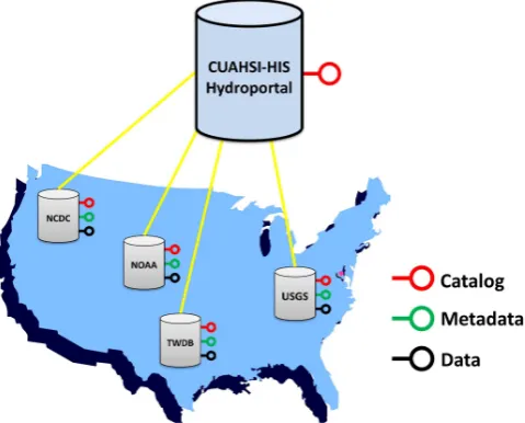
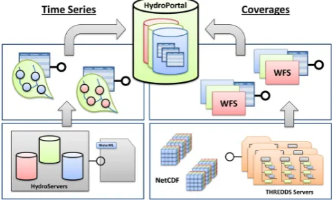
By organizing hydrologic and atmospheric science infor-mation in this manner, data publishers have the ability to maintain and manage their own metadata and data while still conforming to standards and participating within a larger in-teroperable information system. In order to leverage this dis-tributed approach, CUAHSI-HIS has created an experimental meta-catalog, called HydroPortal, which functions as a cata-log of catacata-logs (or catacata-log gateway). See Fig. 9.
Fig. 8. Example Web Feature Service (WFS) response containing coverage metadata.
Fig. 9. Distributed CUAHSI-HIS HydroPortal.
system. In contrast, the services stack framework is a dis-tributed approach where metadata, time series or coverage, can be harvested and indexed by multiple systems instead of one. Furthermore, because HydroPortal is consistent with the OGC framework, a user would have access to all the underlying metadata and data via the CSW interface. This could be demonstrated by registering the HydroPortal within the Global Earth Observation System of Systems (GEOSS); however, this has yet to be tested.
3.3 Comparison and relations between CUAHSI and Unidata frameworks
In the previous section, a framework for sharing both hy-drologic and atmospheric data was presented and described. This framework conforms to OGC standard Web services and allows data providers to publish and manage their own data while giving data users the ability to readily discover and ac-cess that data. Within this system, hydrologic metadata and data, stored on CUAHSI-HIS HydroServers, are published using the suite of OGC standard Web services described in the services stack framework. Similarly, atmospheric science metadata and data stored on THREDDS servers are pub-lished in the same manner. As of 2011, CUAHSI has begun to migrate the existing CUAHSI-HIS to the OGC standard framework described above. Although this is a promising first step, there are currently hundreds of THREDDS servers worldwide that contain atmospheric science data and are not a part of the CUAHSI-HIS system.
Fig. 10. Correspondences between existing services in the
CUAHSI-HIS and Unidata frameworks.
Unidata services stack. The figure describes a terminology divide that exists between the two frameworks, and at the same time helps cross it.
At the topmost level of the CUAHSI-HIS framework, a meta-catalog service is found. This service, implemented as a CSW, is used to discover metadata services by distributing incoming queries to a set of federated catalogs (implemented as CSW as well), realizing a catalog gateway or clearing-house system. Each of the federated catalogs can be queried to find one or more time series published by the metadata service, implemented as WFS. Each time series contains in its metadata a pointer to the data service, implemented as a SOS. This last service can be used to obtain the raw data, as acquired by the sensors.
Within the Unidata framework there lies a similar system. At the topmost level of the Unidata framework there is a bro-ker service, implementing discovery interfaces such as CSW and OpenSearch. A broker distributes user queries to a set of heterogeneous services (i.e. catalogs services, but also ventory and access services), realizing also a distributed in-frastructure functioning as a resources registry. Beneath, the catalog service type is shown, implemented as a CSW. A catalog service is able to harvest the available metadata of-fered by THREDDS services, and executes complex queries against the available metadata. Metadata can also be har-vested directly from WCS services in a fashion similar to the CUAHSI-HIS framework. THREDDS services work as an inventory (or listing) service, being able to hierarchically organize and publish a local collection of multi-dimensional arrays (e.g. netCDF, GRIB files), as well as publish auxiliary standard services to realize the actual data access and visual-ization (e.g. WCS, OPeNDAP, WMS).
4 Interoperability experiments
Based on the design concepts presented in the previous sec-tions, two interoperability experiments were performed using a variety of clients, tools and interfaces. These experiments were conducted to demonstrate data interoperability by en-abling users to search, discover and access both hydrologic and atmospheric science data through an implementation of a standard set of OGC compliant web services.
The first interoperability experiment in this study was based on the CUAHSI-HIS services stack framework and was implemented using ESRI’s GeoPortal interface. Geo-Portal is a free open source product designed by ESRI that empowers users to discover a collection of registered ser-vices via their metadata (ESRI, 2012). Along with its Web based GUI interface, GeoPortal also allows users to search for records through its CSW interface. The second experi-ment in this study was based on the Unidata framework and the GI-cat mediation software. GI-cat is an implementation of a broker catalog service designed by ESSI-Lab.
These experiments were chosen to answer the following questions:
1. Can one publish hydrologic and atmospheric science data (i.e. time series and coverages) in a common man-ner that would allow a client to systematically discover and access data by applying spatial, temporal and se-mantic filters?
2. Is it possible to integrate CUAHSI time series services into existing portals and gateways within the Earth sci-ence community?
The answers to these questions will be provided through the following experiments and will demonstrate a proof of concept for the proposed interoperability solutions. Not only is it important to demonstrate a framework which empowers interoperability but also one that is in line with other existing interoperable systems.
4.1 Experiment #1: GeoPortal
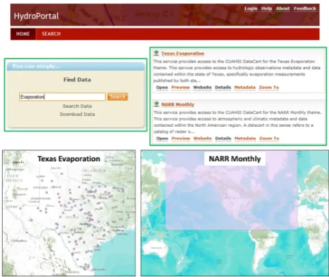
The first interoperability experiment was performed in accor-dance to the CUAHSI-HIS services stack framework. A set of hydrologic data services published on CUAHSI-HIS Hy-droServers (e.g. time series data services) were thematically organized using the CUAHSI metadata specification. Once organized within a table, the metadata catalog was ingested into ArcGIS as a point feature class and then published as a WFS using ArcGIS Server; see Fig. 7 for reference. The ser-vice was then registered in a central catalog via CUAHSI’s version of ESRI’s Geoportal, HydroPortal.
Fig. 11. List of metadata services, implemented as WFS, returned
by experimental CUAHSI-HIS HydroPortal (keyword “Evapora-tion” was used as the semantic query).
are returned. Figure 12 shows a metadata record within Hy-droPortal implemented through its CSW interface.
As has been demonstrated by Seppi (Seppi, 2010), a client can be built to systematically discover and access informa-tion organized in this fashion. Clients can also apply filters (either at the CSW or WFS level) to spatially, temporally, and semantically sift through the returned metadata and then efficiently access the data of interest either through an SOS or WCS request. See Fig. 13 for an abstract layout of this process.
4.2 Experiment #2: GI-cat
The second interoperability experiment in this study was performed using ESSI-Lab’s GI-cat service (Bigagli et al., 2004). A GI-cat service implements a discovery broker within the publish, find, bind SOA.
GI-cat allows a client to query heterogeneous data sources and services through a common discovery interface by bind-ing directly to the different service types and mediatbind-ing be-tween the multiple service providers and the client (Nativi et al., 2009). GI-cat supports several international and commu-nity standards and services: catalog services (such as CSW in its ISO and ebRIM profiles, OpenSearch engines, Degree and GeoNetwork); inventory services (such as THREDDS, OAI-PMH, Web Accessible Folders, FTP); access services (such as WCS, WMS, WFS); and local folders and databases (with support for different formats such as ISO19139, DIF, Dublin Core, netCDF).
GI-cat provides a flexible framework to interconnect het-erogeneous resources (i.e. data repositories and services) by means of a mediation and adaptation approach (Nativi et al., 2007). For each resource type, the protocol and data model
mediation functionalities are implemented by a specific soft-ware component called an “Accessor”. New “Accessors” can be added to the system in order to support the discovery and access of a new resource type. This standard based approach allows to interconnect, in a loosely-coupled way, existing and even future resources.
At the same time GI-cat can be accessed by different discovery clients such as ArcGIS, the GEO/GEOSS Portal, GeoNetwork, GI-go Geobrowser and its own built-in Web portal. The software components which carry out the pub-lication of specific catalog interfaces are called “Profilers”. They carry out mediation functionalities between the pub-lished interfaces and the GI-cat internal interface. Just like the Accessors, new Profilers can be created and plugged into the system in order to publish new discovery interfaces. Queries can be executed on the fly against the available sources or a local metadata collection, periodically updated by a specific component (called the Harvester); a mixed strat-egy can be easily configured in order to tailor the broker to the desired user scenario.
Within the context of this study, GI-cat was used to harvest approximately 400 000 metadata records describing gridded resources from the Motherlode THREDDS server hosted at Unidata (see Fig. 14). These resources include gridded data from the National Center for Environmental Prediction (NCEP), the Unidata Real-time Regional Model, Next Gen-eration Radar (NEXRAD), satellites and others (nearly all re-sources are available via a WCS implementation). The meta-data of those resources were then made available for discov-ery through a CSW ISO interface published by GI-cat. The optional link needed to inject metadata resources from HIS Central directly into GI-cat is also shown in Fig. 14 with a dotted line, however it was not used for the described tests; it may be subject of further tests.
Queries to the configured system can be issued by any CSW client by using a combination of the standard ISO queries, as defined in the CSW ISO AP specification (e.g. geographic extent, keywords, temporal extent etc.). In this experiment, different clients were used to retrieve metadata from the described system: GI-go GeoBrowser, GeoNet-work, ArcGIS Explorer and also a built-in Web portal within GI-cat. GI-cat can also publish other interfaces beside the CSW/ISO interface used for the tests (e.g. OpenSearch, OAI-PMH, etc.); these additional configurations may be subject to future tests.
Fig. 12. Example record within HydroPortal via its CSW interface (Seppi, 2010).
Fig. 13. Data and metadata services registered within CUAHSI-HIS
HydroPortal.
metadata records through a common interface. Figure 15 shows a general representation of the implemented test case. The sequence diagram for harvesting data services can be seen in Fig. 16. During the harvesting phase, the user first triggers the HIS servers, followed by the Motherlode servers (alternatively these can be triggered through an automatic
timer). The catalog services then store the data services in-crementally through a loop (possibly after translation).
Figure 17 shows the sequence diagram and interaction be-tween components during a typical query from HydroPortal. HydroPortal distributes the incoming query to HIS Central and GI-cat services at the same time, acting as a gateway. The results are then returned as shown in its GUI interface. The entire query process from user input to returned results takes a few seconds, thus making this test case a viable op-tion for producop-tion scenarios.
5 Conclusions
Fig. 14. GI-cat experimental deployment diagram.
Fig. 15. Abstract diagram of interoperable data discovery system;
hydrologic and atmospheric science data indexed within HydroPor-tal.
OGC compliant web services) can. It has been demonstrated that within hydrologic sciences, CUAHSI-HIS is a leading provider of time series data, while Unidata (within atmo-spheric sciences) is a leading provider of gridded data. This work has shown that through the use of standard Web ser-vices, federated catalogs can be built which can integrate data across multiple scientific domains. Within the context of this study, hydrologic data services published on HydroServers can be managed and indexed in a HydroPortal, while atmo-spheric data services published on THREDDS servers can be managed and indexed through a service mediator such as GI-cat. Because both of these interfaces allow data to be pub-lished and indexed through CSW interfaces, these individual catalogs can be aggregated within one meta-catalog to facili-tate the discovery and access to interoperable data. However, it must be noted that no system can be successful without using a sound semantic ontological framework and complete metadata structure.
Although there have been significant advancements made in the sharing of scientific information, there still remain many unanswered questions. With respect to this research, it is still not clear how to deal with gridded data services in real-time. These data services provide access to copious amounts of gridded information that are continually updated. Both the high frequency of the updates and the high detailed
granularity of the datasets constitute present issues to the data consumer wanting to effectively search through the data us-ing spatial, temporal and semantic filters. These issues may be overcome by providing services which aggregate and or-ganize massive amounts of data streaming in real-time or by providing “granularity filters”. Furthermore, the question of how to deal with multiple ontologies has yet to be an-swered. Within hydrologic sciences, the CUAHSI Ontology has proven to be a successful approach to handling seman-tic filters; however within atmospheric sciences the CF Con-ventions are more widely used. Probably each discipline will prefer to use its own ontology and index the information pro-vided by other disciplines in a consistent manner with that.
Future work will be dedicated to clients that seamlessly in-tegrate the suite of interconnected services presented in this study. These clients will discover a set of metadata records (i.e. the existence of a dataset, what region it is in and what it contains) through a CSW interface. The expectation is that they will then utilize the WFS implementation to identify variables contained within a dataset (in addition to its spa-tial coverage, time extent, units etc.), and finally, the SOS and WCS implementation to directly access the dataset of interest. Moreover, with the integration of Web Processing Services (WPS), clients can have the ability to access value added information products such as indices. Some of this technology has already been demonstrated by Blodgett et al. (2011).
Fig. 16. Sequence diagram showing the harvesting of data services to the catalogs.
Acknowledgements. This work was supported by the National
Science Foundation under grant #0622374. Any opinions, findings and conclusions expressed in this paper are those of the authors and do not necessarily reflect the views of the National Science Foundation.
Edited by: A. Parodi
Reviewed by: two anonymous referees
References
Alameh, N. S., Bambacus, M. J., Evans, J. D., and Marley, S. R.: NASA’s Earth Science Gateway: A Platform for Interoperable Services in Support of the GEOSS Vision, Geoscience and Re-mote Sensing Symposium, IGARSS 2006, 2477–2480, 2006. Ames, D. P., Kadlec, J., and Horsburgh, J.: HydroDesktop: A Free
and Open Source Platform for Hydrologic Data Discovery, Vi-sualization, and Analysis, 2010 AWRA Spring Specialty Con-ference: Geographic Information Systems (GIS) and Water Re-sources VI, Orlando, Florida, March 2010, TPS-10-1, ISBN 1-882132-82-3, 2010.
Bermudez, L. and Arctur, D.: OGC Engineering Report: Water In-formation Services Concept Development Study, OGC 11-013r6, available at: http://portal.opengeospatial.org/files/?artifact id= 44834, July 2011.
Bermudez, L. and Piasecki, M.: Metadata Community Pro-files for the Semantic Web, Geoinformatica, 10, 159–176, doi:10.1007/s/10707-006-7577-2, 2006.
Bigagli, L., Nativi, S., Mazzetti, P., and Villoresi, G.: GI-cat: a Web service for dataset cataloguing based on ISO 19115, in: Proceed-ings of 15th International Workshop on Database and Expert Sys-tems Applications, 846–850, August 2004.
Blodgett, D. L., Booth, N. L., Kunicki, T. C., Walker, J. I., and Viger, R. J.: Description and Testing of the Geo Data Portal: A Data In-tegration Framework and Web Processing Services for Environ-mental Science Collaboration, US Geological Survey, Open-File Report 2011-1157, Reston, Virginia, 2011.
CUAHSI HIS: Sharing hydrologic data, available at: http://his. cuahsi.org, last access: 31 March 2012.
Domenico, B., Caron, J., Davis, E., Kambic, R., and Nativi, S.: Thematic Real-time Environmental Distributed Data Ser-vices (THREDDS): Incoporating Interactive Analysis Tools into NSDL, Journal of Digital Information, 2, 4, May 2002. Domenico, B., Nativi, S., Caron, J., Bigagli, L., and Davis, E.:
GA-LEON: standards-based web services for interoperability among Earth sciences data systems, in: Proceedings of IGARSS’06, Denver, Colorado, July 2006.
Doraiswamy, P., Pasteris, P., Jones, K., Motha, R., and Nejedlik, P.: Techniques for Methods of Collection, Database Management and Distribution of Agrometeorological Data, Agr. Forest Mete-orol., 103, 83–97, doi:10.1016/S0168-1923(00)00120-9, 1999. Earth and Space Science Informatics – Laboratory (ESSI-Lab):
available at: http://essi-lab.eu, last access: 31 March 2012. Environmental Systems Research Institute: Geoportal Server, last
access: 10 February 2012.
Fielding, R.: Architectural styles and the design of network-based software architectures (Doctoral dissertation), University of Cal-ifornia, Irvine, 2000.
Fox, P.: Earth & Space Science Informatics Summit Report, Rome, March 2008.
Garlan, D. and Shaw, M.: An introduction to software architecture, in: Advances in Software Engineering & Knowledge Engineer-ing, edited by: Ambriola, V. and Tortora, G., World Scientific Pub Co., Singapore, Volume II, 1–39, 1993.
Giuliani, G., Ray, N., Schwarzer, S., Bono, A. D., Peduzzi, P., Dao, H., Woerden, J. P., Witt, R., Beniston, M., and Lehmann, A.: Sharing Environmental Data through GEOSS, Int. J. Appl. Geospatial Res., 2, 1–17, 2011.
Horsburgh, J., Tarboton, D., Piasecki, M., Maidment, D., Zaslavsky, I., Valentine, D., and Whitenack, T.: Overcoming Semantic Het-erogeneity in Publishing Environmental and Water Resources Data, Environ. Model. Softw., 24, 879–888, 2009.
Horsburgh, J., Tarboton, D., Schreuders, K., Maidment, D., Za-slavsky, I., and Valentine, D.: HydroServer: A platform for pub-lishing space-time hydrologic datasets, in: Proceedings of 2010 AWRA Spring Specialty Conference Geographic Information Systems (GIS) and Water Resources VI, Orlando, Florida, 2010. INSPIRE, Infrastructure for Spatial Information in Europe: IN-SPIRE Metadata Implementing Rules: Technical Guidelines based on EN ISO 19115 and EN ISO 19119, European Com-mission Joint Research Center, 16 June 2010.
Maidment, D.: Arc Hydro: GIS for Water Resources, ESRI Press, Redlands, California, 2002.
Maidment, D.: CUAHSI Hydrologic Information System: 2009 Sta-tus Report, Consortium of Universities for the Advancement of Hydrologic Science, Inc., October 2009.
Maidment, D., Salas, F., Domenico, B., and Nativi, S.: Crossing the Digital Divide: Connecting GIS, time series and space-time arrays, AGU Fall Meeting, San Francisco, California, IN13A-1095, December 2010.
McDonald, K., Enloe, Y., Di, L., and Holloway, D.: A Gateway to Support Interoperability of OPeNDAP and OGC Protocols, Geo-science and Remote Sensing Symposium, IGARSS 2006, 301– 304, 2006.
Meertens, C., Wier, S., Murray, D., McWhirter, J., and Memon, A.: The GEON IDV (Integrated Data Viewer) for data exploration and discovery in the geosciences. Eos Transactions AGU, Fall Meeting, IN31A-1306, 2006.
Nativi, S. and Bigagli, L.: Discovery, Mediation, and Access Ser-vices for Earth Observation Data, Appl. Earth Obs. Remote Sens., 2, 233–240, 2009.
Nativi, S. and Domenico, B.: Enabling interoperability for Digital Earth: Coverage access services, Int. J. Digital Earth, 2, Supple-ment 1, 79–104, 2009.
Nativi, S., Blumenthal, B., Habermann, T., Hertzmann, D., Raskin, R., Caron, J., Domenico, B., Ho, Y., and Weber, J.: Differences among the data models used by the Geographic Information Sys-tems and Atmospheric Science communities, in: Proceedings of AMS – 20th IIPS Conference, Seattle, Washington, January 2004.
Nativi, S., Caron, J., Davis, E., and Domenico, B.: Design and implementation of netCDF Markup Language (NcML) and its GML-based extension (NcML-GML), Comput. Geosci. J., 31, 1104–1118, 2005.
Nativi, S., Bigagli, L., Mazzetti, P., Mattia, U., and Boldrini, E.: Dis-covery, query and access services for imagery, gridded and cover-age data a clearinghouse solution, Geoscience and Remote Sens-ing Symposium, 2007. IGARSS 2007, IEEE Int., 4021–4024, 2007.
Nativi, S., Bigagli, L., Mazzetti, P., Boldrini, E., and Papeschi, F.: GI-cat: A Mediation Solution for Building a Clearinghouse Cata-log Service, Advanced Geographic Information Systems & Web Services, 2009, GEOWS ’09, International Conference on, 1–7, 68–74, 2009.
Nativi, S., Khalsa, S. J., Domenico, B., Craglia, M., Pearlman, J., Mazzetti, P., and Rew, R.: The Brokering Approach for Earth Science Cyberinfrastructure, NSF EarthCube White Paper, 2011. Nativi, S., Craglia, M., and Pearlman, J.: The Brokering Approach for Multidisciplinary Interoperability: A Position Paper, Int. J. Spatial Data Inf. Res., 7, 1–15, 2012.
Nebert, D.: The SDI Cookbook, GSDI, 2.0 Edn., January 2004. Oasis: Reference Model for Service Oriented Architecture 1.0,
Oa-sis Standard, OaOa-sis, 12 October 2006.
Open Geospatial Consortium: Web Feature Service Implementation Specification, Open Geospatial Consortium, 3 May 2005. Open Geospatial Consortium: OpenGIS Catalogue Services
Speci-fication, Open Geospatial Consortium, 23 February 2007a. Open Geospatial Consortium: Sensor Observation Service, Open
Geospatial Consortium, 26 October 2007b.
Open Geospatial Consortium: Web Coverage Service (WCS) Im-plementation Standard, Open Geospatial Consortium, 19 March 2008.
Open Geospatial Consortium: NetCDF Binary Encoding Exten-sion Standard: NetCDF Classic and 64-bit Offset Format, Open Geospatial Consortium, 27 August 2010.
Open Geospatial Consortium: OGC Network Common Data Form (NetCDF) Core Encoding Standard version 1.0, Open Geospatial Consortium, 5 April 2011.
Open Geospatial Consortium: available at: http://www. opengeospatial.org/ogc, last access: 1 February 2012.
Ortiz, S.: Getting on Board the Enterprise Service Bus, IEEE Com-puter, 40, 15–17, doi:10.1109/MC.2007.127, 2007.
Padmanabhan, A., Wang, S., and Navarro, J.: A CyberGIS Gate-way Approach to Interoperable Access to the National Science Foundation TeraGrid and the Open Science Grid, Proceedings of the 2011 TeraGrid Conference: Extreme Digital Discovery, Salt Lake City, Utah, doi:10.1145/2016741.2016786, 18 July 2011. Piasecki, M. and Beran, B.: A Semantic Annotation Tool for the
Hydrologic Sciences, Earth Sci. Inf., 2, 157–168, 2009.
Ramamurthy, M. K.: A new generation of cyberinfrastructure and data services for earth system science education and research, Adv. Geosci., 8, 69–78, doi:10.5194/adgeo-8-69-2006, 2006. Rui, H., Teng, W., Vollmer, B., Mocko, D. M., Beaudoing, H. K.,
Nigro, J., Gray, M., Maidment, D., and Hooper, R.: Bridging the gap between NASA hydrological data and the geospatial commu-nity, in: Proceedings of ASPRS 2011 Annual Conference, Mil-waukee, Wisconsin, 2011.
Schmidt, M. T., Hutchison, B., Lambros, P., and Phippen, R.: The Enterprise Service Bus: Making service-oriented architec-ture real, IBM Systems J., 44, 781–797, doi:10.1147/sj.444.0781, 2005.
Seppi, J. A.: A Services Stack Architectural Model for CUAHSI-HIS (Master’s thesis), University of Texas at Austin, 2010. Tarboton, D., Maidment, D., Zaslavsky, I., Ames, D., Goodall,
J., and Horsburgh, J.: CUAHSI Hydrologic Information System 2010 Status Report, Consortium of Universities for the Advance-ment of Hydrologic Science, Inc., November 2010.
Tarboton, D., Maidment, D., Zaslavsky, I., Ames, D., Goodall, J., Hooper, R., Horsburgh, J., Valentine, D., Whiteaker, T., and Schreuders, K.: Data Interoperability in Hydrologic Sciences, The CUAHSI Hydrologic Information System, Proceedings of the Environmental Information Management Conference 2011, Santa Barbara, United States, 28–29 September 2011, 132–137, 2011.
Vector 1 Media, Interoperability Science Re-quires a Cultural Dialog: available at: http: //www.vector1media.com/dialog/interviews/
11878-interoperability-science-requires-a-cultural-dialog.html, last access: 10 February 2012.
Unidata: providing data services, tools and cyberinfrastructure lead-ership, available at: http://www.unidata.ucar.edu/, last access: 31 March 2012.
Whitenack, T., Valentine, D., Zaslavsky, I., Piasecki, M., Tarboton, D., Horsburch, J., Whiteaker, T., Ames, D., and Maidment, D.: Hydrologic metadata catalog and semantic search services in CUAHSI HIS, in: 2010 AWRA Spring Specialy Conference: Geographic Information Systems (GIS) and Water Resources VI, American Water Resources Association, TPS-10-1, ISBN 1-882132-82-3, March 2010.
Wiederhold, G.: Mediators in the architecture of future information systems, IEEE Computer, 25, 38–49, 1992.