University of New Orleans University of New Orleans
ScholarWorks@UNO
ScholarWorks@UNO
University of New Orleans Theses and
Dissertations Dissertations and Theses
12-17-2010
Configuration of the Pleistocene Surface Beneath Cat Island,
Configuration of the Pleistocene Surface Beneath Cat Island,
Mississippi and Implications for Barrier Island Formation and
Mississippi and Implications for Barrier Island Formation and
Evolution
Evolution
Kathryn Rose
University of New Orleans
Follow this and additional works at: https://scholarworks.uno.edu/td
Recommended Citation Recommended Citation
Rose, Kathryn, "Configuration of the Pleistocene Surface Beneath Cat Island, Mississippi and Implications for Barrier Island Formation and Evolution" (2010). University of New Orleans Theses and Dissertations. 1259.
https://scholarworks.uno.edu/td/1259
This Thesis is protected by copyright and/or related rights. It has been brought to you by ScholarWorks@UNO with permission from the rights-holder(s). You are free to use this Thesis in any way that is permitted by the copyright and related rights legislation that applies to your use. For other uses you need to obtain permission from the rights-holder(s) directly, unless additional rights are indicated by a Creative Commons license in the record and/or on the work itself.
Configuration of the Pleistocene Surface Beneath Cat Island, Mississippi, and Nearshore: Implications for Barrier Island Formation and Evolution
A Thesis
Submitted to the Graduate Faculty of the University of New Orleans in partial fulfillment of the requirements for the degree of
Master of Science in
Earth and Environmental Sciences Coastal Geology
by
Kathryn Virginia Georgina Rose
B.G.S., University of New Orleans, 2007
Acknowledgements
The U.S. Geological Survey and the University of New Orleans funded this study cooperatively,
and many people contributed to its completion. First, I would like to thank my co-advisors, Dr. Dawn Lavoie, U.S. Geological Survey, and Dr. Mark Kulp, University of New Orleans for their
mentoring, assistance in arranging the geophysical surveys, interpreting data and reviewing this manuscript. The input of my committee members, Dr. Mike Miner and Dr. Ioannis Georgiou, has also been invaluable. I would also like to thank Phil McCarty, Dallon Weathers and Dane
Fischer with UNO, and Nancy DeWitt and Dana Weise with the USGS St. Petersburg Coastal and Marine Science Center for their help in carrying out the surveys; Arnelle Harrison, also with
the USGS St. Petersburg Coastal and Marine Science Center for processing the SB-424 chirp data; and Elizabeth Pendleton with the USGS Woods Hole Seafloor Mapping Group for
processing the bathymetry data and lending her expertise on processing methods. I am extremely
grateful to Jim Flocks with the USGS St. Petersburg Science Center for making equipment and staff available. Finally, I would like to thank George Boddie for providing access to Cat Island
Table of Contents
List of Figures ... vi
Abstract ... ix
Introduction ...1
Hypothesis...4
Background ...5
Quaternary Evolution of the Northern Gulf of Mexico ...5
Barrier Islands ...13
Conceptual Models of Barrier Island Formation ...15
Early barrier formation hypotheses ...15
Shoreline engulfment hypothesis of barrier island development ...17
Composite barrier island development hypotheses...22
Beach Ridges ...24
Present-Day Regional Background and Conditions ...26
Holocene Evolution of Mississippi Sound ...28
Central and Eastern Mississippi Sound...28
Western Mississippi Sound ...32
Present-Day Geomorphology of Cat Island, MS ...38
Island Erosion Trends ...42
Methods...48
Existing Datasets ...48
Mississippi State Geological Survey Borehole Data ...48
USACE Atlas Data ...49
Mississippi Minerals Resource Institute (MMRI) Reports ...50
Velardo, 2005 Data ...51
Data Collection ...51
Survey Preparation ...53
Data Acquisition ...55
Edgetech SB-216S survey...55
Edgetech SB-424 and single beam bathymetry survey...55
Post-Survey Processing ...57
Seismic Data Post-Processing ...57
Bathymetry Data Post-Processing...58
Pleistocene Surface Mapping ...58
Results ...61
Pleistocene Surface Contours ...61
Recent Holocene Features ...66
Discussion ...69
Proposed Model for the Development and Evolution of Cat Island ...73
Predicted Future Trends on Cat Island...77
Summary ...79
Appendix ...88
Table 1. Survey Line Numbers with Corresponding Seismic File Numbers ...88
Table 2. Characteristics of Sediments Recovered from Well HC-199 ...90
Table 3. Characteristics of Sediments Recovered from Well HC-200 ...91
Table 4. Gross Descriptions of MMRI Vibracores ...92
Table 5. Gross Descriptions of GRCL Drill Cores ...93
List of Figures
Figure 1. Map of the Northern Gulf of Mexico and Mississippi Sound. Study area is within red dashed line ...2 Figure 2. Composite map showing the geographic locations and extent ofincised valleys of the most recent sea level lowstand, Oxygen Isotope Stage 2, PV: Pearl Incised Valley (Kindinger, 1988; Kindinger et al., 1994); PIV: Pascagoula Incised Valley (Kindinger, 1988; Kindinger et al., 1994); MV: Mobile Incised Valley (Hummel and Parker, 1995 b; Kindinger et al., 1994; Mars et al., 1992); WMV: West Mobile Valley (Bartek et al, 2004); EMV: East Mobile Valley (Bartek et al., 2004), and shelf edge deltas, EMD (Bart and Anderson, 2004; Bartek et al., 2004) and EMD-S (EMD-Sager et al., 1999): East Mobile Deltas; WMD (Bartek et al., 2004), WMD-EMD-S (EMD-Sager et al., 1999): West Mobile Deltas; Lagniappe Delta (Kindinger, 1988; 1989 a; 1989 b; Bartek et al., 2004; Roberts et al., 2004), (Greene et al, 2007). ...6 Figure 3. Geographic distribution and proposed chronology for Holocene delta complexes of the Mississippi River (modified from Frazier, 1967) ...7 Figure 4. Depositional provinces in the northern Gulf of Mexico by mineralogy type, with
Eastern Gulf and Mississippi Province transition zone highlighted (modified from Van Andel, 1960) ...8 Figure 5. Oxygen-Isotope Stages and inferred sea level fluctuations for the past 180,000 years (Morton and Suter, 1996) ...10 Figure 6.Three-Stage Transgressive Barrier Island model (modified Penland and Boyd, 1981) .23
Figure 7. Cross section of Mississippi Sound showing interpreted lithofacies from acoustic reflectance survey (Curray and Moore, 1963) ...29
Figure 8. Interpreted geologic cross-section, north to south, through Dauphin Island, AL (Otvos, 1985 a) ...32 Figure 9.Conceptual model for barrier island chain and associated delta plain development (Otvos and Giardino, 2004) ...34 Figure 10. Locations of vibracores (Barnhardt, 2003; Otvos, 1986 b; Velardo, 2005) and well borings (Brown et al., 1944; Otvos, 1985 b) acquired during previous studies on and around Cat Island, MS. ...36
Decision Support for Coastal Science and Resource Management Project,
http://coastal.er.usgs.gov/remote-sensing) ...38 Figure 12. Beach ridge sets on Cat Island, MS from oldest (1) to youngest (3) (Rucker and
Snowden, 1989). ...39 Figure 13. Time series showing shoreline change on Cat Island, MS from 1848 to 2005 (Morton, 2008) ...41 Figure 14. Interpreted cross section northwest-southeast across Cat Island based on cores HC-199 and HC-200 (Dunbar et al., HC-1995) ...49 Figure 15. Planned survey trackline grid ...52
Figure 16. Acquired survey lines and extent of area of poor seismic penetration (barrier island platform) ...54
Figure 17. Contour map of the Pleistocene surface surrounding and underlying Cat Island, MS and locations and depths of vibracores (Otvos, 1986; Velardo, 2005) and well borings (Brown et al., 1944; Otvos, 1985 b) acquired during previous studies on and around Cat Island. Shading represents areas where clusters of depth-value points derived from the seismic data are present, but unable to be contoured. A to A’ indicates the strike of barrier cross-section shown in figure 24...60
Figure 18. Pleistocene surface reflectors in seismic profiles (SB-216S) from survey lines 104 (north to south) and 105 (east to west) in the canals. The surface is irregular, and incised by paleochannels in the north-south line ...62
Figure 19. Seismic imagery of survey line 4 showing the Pleistocene surface reflector onlapped by Racoon Shoal facies ...64
Figure 20. Seismic profile (SB-424) of line 100 showing truncated gulfward-prograded sharp-based facies ...66
Figure 21. Seismic profile (SB-424) of line 119 showing east and west dipping truncated
prograded facies dipping away from each other ...66 Figure 22. Locations of truncated ridge facies and retrograded barrier island facies ...67 Figure 23. Seismic profile (SB-424) of line 13 showing retrograded barrier platform facies ...68
Figure 24.Geologic cross-section from north to south across Cat Island and nearshore zones. Time intervals (T0 toT4) correspond to the four stages of Cat Island development. Location of
Abstract
The mechanism of Holocene barrier formation aids in determining island geomorphologic
responses to modifying climatic processes of the surrounding environment. The geometry and composition of local antecedent topography plays a role in barrier formation by providing an
elevated base, nucleus for sedimentation and local sediment supply. Investigation of barriers’ subsurface geology provides insight into island formation and evolution. High-resolution shallow seismic data acquired in the island’s nearshore zone and interior canals, correlated with existing
drillcore data, reveal that Cat Island, MS is situated over an Oxygen Isotope Stage 3 Phase 3 paleochannel located between two topographic high-grounds of the Pleistocene surface. Beach
ridge strandplain sets on Cat Island provide additional evidence supporting the island’s formation over a relict depocenter. A new, 4-stage model for Cat Island development and evolution
incorporating the influence of pre-existing topographic high-grounds and abundant local
sediment supply provided by a backfilling fluvial channel is presented here.
Introduction
The inception, evolution and fate of mid-Holocene coastal plain barrier islands along the Gulf of Mexico and the Atlantic coasts has been the subject of ongoing debate in scientific
literature (Curray and Moore, 1963; Swift, 1975; Field and Duane, 1976, 1977; Hoyt, 1967, 1970; Otvos, 1970; Otvos and Giardino, 2004; Schwartz, 1971; Swift, 1975; Tanner, 1990). After the 2005 Atlantic hurricane season when Hurricane Katrina inundated mainland
Mississippi with storm surge of as much as 8.5 m at Pass Christian, the highest reported for that storm (National Hurricane Center [NHC], 2005), local, state and federal agencies have partnered
to evaluate the condition of the deteriorating Mississippi barrier islands and develop restoration and management measures as part of a comprehensive storm protection and ecosystem
restoration program (the Mississippi Coastal Improvement Program, or MSCIP, U.S. Army
Corps of Engineers [USACE], 2009). Future decisions relating to the islands’ management depend on their present state and the integrity and condition of the sand resources available for
restoration, prompting a need for detailed geologic characterization of the region.
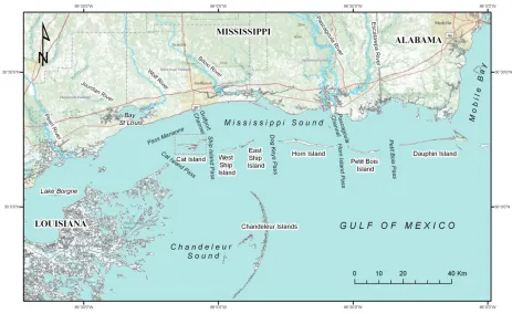
The Mississippi-Alabama (MS-AL) barrier islands form a linear chain approximately 104
km long along the north-central Gulf of Mexico coast 9-19 km-wide Mississippi Sound. From east to west, the chain includes Dauphin, Horn, East and West Ship, and Cat Islands (figure 1). These islands (excluding Dauphin Island, which is developed, and part of Cat Island which is
privately owned) are part of the National Park System’s Gulf Islands National Seashore (GUIS), which also includes parts of Santa Rosa Island in Florida. In 2002, the National Park Service
popular recreation area containing several historical and archaeological sites documenting the
settlement and colonization of the Gulf region (NPS, 2009).
Perhaps because of its private ownership status, few studies have been conducted on Cat Island and its near-shore area, despite its unique position where processes associated with both
Holocene coastal plain and Mississippi River delta plain evolution have influenced various stages of its geomorphic evolution producing well-preserved progradational beach ridge sets and
the north-south trending spits that result in the island’s distinctive T-shaped morphology (Otvos and Giardino, 2004). This study incorporates shallow high-resolution chirp seismic data from
surveys conducted in 2008 and 2009 around Cat Island with existing drill core data and vibracore data taken on the island and in the immediate offshore. The previously acquired data are used to help define the depth and geometry of the underlying Pleistocene surface. This study proposes
that Cat Island may have originated as mid to late Holocene sediments aggraded over an existing Pleistocene ridge that provided a stable island core, anchoring the successive sedimentary units
that evolved into the modern barrier island. Presence of an underlying topographic high may explain the island’s anomalous evolution and geomorphology relative to the other units of the
MS-AL barrier island system. This information will enable managers to anticipate the island’s geomorphologic response to future climatic stressors, such as sea level rise and extreme storms and to prioritize the restoration needs of the barrier island system. This study also contributes to
ongoing research efforts to refine the geologic history and development of the northern Gulf coastal region and to understand and predict coastal response to tropical cyclone impacts and
Hypothesis
This study proposes that the lateral stability and unique shape of Cat Island may be controlled by the presence of a pre-Holocene topographic high, presently underlying Cat Island,
that provided a nucleus for sand accretion and continues to influence island position and
stability. Improved understanding of the configuration of the Pleistocene surface underlying and in the vicinity of Cat Island will help to resolve questions regarding island formation and
Background
Quaternary Evolution of the Northern Gulf of Mexico
The geologic evolution of the Northern Gulf of Mexico has been controlled by eustatic glacial-interglacial cycles and corresponding changes in sea level (Anderson et al., 2004; Boyd et
al., 1989; Curray, 1960; Fisk, 1947; Fisk, et al, 1954; Frazier, 1967; Kindinger, 1988, 1989; Kindinger et al, 1989; Kulp et al., 2002; Lopez et al., 1997; McBride et al., 2004; Morton and Boyd, 1996; Otvos, 2005 b; Shepard, 1960 b; Wilkinson, 1975). Sea level fluctuation is a forcing
mechanism responsible for erosional and depositional sequences that affect the geomorphology of coastal and marine sedimentary systems. Transgressing and regressing shorelines alter the
hydrodynamic environment across marine basins by re-working and re-distributing surficial sediment. Depocenters migrate landward or seaward and laterally as changing shelf gradients cause rivers to avulse (Scruton, 1960). Submerged surfaces can be eroded or preserved while
subaerially exposed surfaces are weathered creating distinct horizons between unconformable sedimentary packages. The resulting lithofacies found in the northern Gulf are the product of the
interactions between sea level fluctuation, sediment supply and the underlying receiving basin geometry (Fisk, 1947; Fisk et al, 1954; Frazier, 1967; Morton and Suter, 1996; Scruton, 1960). Subsurface mapping of the northern Gulf of Mexico continental shelf has identified multiple
paleochannel and deltaic complexes constructed during the major stages of glacial-interglacial cycles of the late Quaternary (Anderson et al., 2004; Boyd et al., 1989; Fisk, 1947; Fisk, et al,
1954; Frazier, 1967; Greene et al, 2007; Kindinger, 1988, 1989; Kindinger et al, 1989; Kulp et al., 2002; Lopez et al., 1997; McBride et al., 2004; Morton and Boyd, 1996; Otvos, 2005 b; Shepard, 1960 b) (figure 2). Sedimentary units representing successive geologic events can be
base and upper limit of transgressive-regressive sequences constrained by glacial cycles (Kindinger, 1988; Kindinger et al., 1989; Morton and Suter, 1996) enabling basin-wide,
(~1.8 Ma ybp) northern Gulf of Mexico geology has been dominated by the Mississippi River system, which, by means of delta switching, deposited multiple overlapping deltas across the continental shelf out to the shelf break. River avulsion, forced by changes in the gradient of the
coastal plain providing more favorable paths to the basin, shifted depocenters to new locations. As active distributaries became progressively abandoned, vertically stacked units of deltaic
sediments formed (Fisk et al., 1954; Frazier, 1963; Scruton, 1960). Abundant sediment supply or falling sea level allowed deltas to prograde out into the basin, whereas abandonment (sediment starvation), rising sea level and subsidence leads to the “destructive” phase of shoreline
submergence and erosion. Fringing barrier islands or shoals in alignment with the former delta
shoreline may be constructed from re-worked deltaic deposits (Penland et al., 1989). Five major
delta complexes of the late Holocene (~7000 ybp) extending from southeast to southwest of the modern Mississippi River form a delta complex that comprises the subaerial land mass of
southern Louisiana have been identified in sedimentary facies (Frazier, 1967; Boyd, et al., 1989; Roberts, 1997; Kulp et al., 2002) (figure 3). Underlying the southeastern margin of the Holocene delta complex is an earlier stage delta from the late Wisconsinan, the Lagniappe delta
(Kindinger, 1989; Kindinger et al., 1994) (figure 2).
Sediments from the Mississippi River dominate the Western Gulf region, extending from
the Mississippi River plain westward to central Texas, are distinct from the sediments of the adjacent Northeastern Gulf region. The Gulf of Mexico encompasses six depositional provinces based on sediment mineralogy and texture, used to identify provenance and age, and amount of
weathering and erosive re-working. Transition zones occur between provinces where type
minerologies can be mixed vertically and laterally (Hsu, 1960; Isphording, 1989; Van Andel, 1960) (figure 4). The Mississippi Province is composed of sediment derived from the continental
sources of the Mississippi River’s extensive watershed. Mississippi Province sediments, dominated by a relatively young, unstable petrologic assemblage, have undergone very little
weathering or diagenetic transformation relative to the Eastern Gulf Province sediments (Van Andel, 1960). The Mississippi River sediments are composed of amphiboles, dolomite,
pyroxenes, epidote, ilmenite and biotite, abundant feldspar and a montmorillonite-illite-kaolinite
suite of clays and (Hsu, 1960; Foxworth et al., 1962; Isphording, 1989; Van Andel, 1960). The northeastern Gulf of Mexico region encompasses the gently sloping continental shelf
south of the present-day Louisiana, Mississippi, and Alabama shorelines out to the shelf break, which lies approximately 75 m below sea level (bsl) (Kindinger, 1988; Kindinger et al., 1989). The late Quaternary sedimentary record is ordered into five chronostratigraphic stages based on
sequences of transgressive-regressive stratigraphic packages (Kindinger, 1988; Kindinger et al., 1989). The major erosional surface horizons and sedimentary boundaries within are correlated by
Kindinger (1988) and Kindinger et al. (1989) with oxygen isotope dates of the glacial-interglacial cycles from the early Wisconsinan lowstand, ~180,000-150,000 ybp to present (Kindinger, 1988; Kindinger et al., 1989; Morton and Suter, 1996) (figure 5). During Stage 1, at
the base of the earliest unit is an erosional surface boundary that formed on the then-subaerial coastal plain, when sea level was at its last major lowstand or regression (early Wisconsinan).
The entire Gulf of Mexico basin was exposed and few incised fluvial channels and deposits were evident. As the climate warmed, North American glacial melt inundated the basin, initiating a transgressive phase. Rapid sea level rise during the middle Wisconsinan (Stage 2, ~120,000 ybp
During Stage 3 (late Wisconsinan, ~85,000 to 24,000 ybp), the northeastern Gulf entered another period of sea level fall. Three phases of Stage 3 are evident in the sedimentary sequences
of this unit, suggesting a stair-stepped regression with a brief stillstand interval. During Phase 1, multiple fluvial networks cut through the mid-shelf, eroding sediment, and in Phase 2 the
regression slowed to a stillstand, allowing for a period of deltaic progradation as alluvial sediments built out to the shelf break (Kindinger, 1988; Kindinger et al., 1989; Greene et al., 2007) (figure 2). The provenance of these alluvial sediments is the metamorphic-intruded rocks
of the Southern Appalachian region. This mineralogic suite (the Eastern Gulf Province) is characterized by a high ratio of stable heavy minerals to quartzose sand and the same suite of
clays, but with decreasing abundance of kaolinite and is predominant through Phase 2 to present-day Northern Gulf sediments (Hsu, 1960; Isphording et al., 1989; Foxworth et al., 1962; Kwon, 1969).
Maximum lowstand of Stage 3 occurred during Phase 3, marking the transition between the Pleistocene and Holocene epochs (Kindinger 1988; Kindinger, 1989). The alluvial plain
extending across the entire Gulf basin was exposed and weathered creating a heavily dissected paleosol, the Type 1 regional unconformity that serves as the base for the subsequent Holocene
facies, also referred to as the Pleistocene surface. Incisions in the surface are the result of erosion by fluvial networks cutting across the inner shelf to the shelf edge, where shelf edge (Type 1) deltas are constructed (Brooks et al, 1995; Greene et al, 2007; Morton and Suter, 1996). The
Pleistocene surface is composed of heavily oxidized, non-fossiliferous clays of the Beaumont formation (Curray and Moore, 1963; Shepard, 1960 a; Brooks et al, 1995; Lopez et al, 1997).
Regionally, the horizon dips to the southwest, following the configuration of the Gulf of Mexico basin (Fisk, 1947) and in the Mississippi Sound, slopes toward the west from 3 m bsl at Horn Island to an average depth of 10 m bsl north of Ship Island (Curray and Moore, 1963). Beneath
Matagorda and St. Joseph Islands, TX in the northwestern Gulf, it has been found at depths of ~7 - ~18 m bsl (Shepard, 1960 a). Incisions in the lowstand surface are the remnant of fluvial
channels that prograded out to the shelf, constructing shelf edge or Type 1 deltas during shoreline regressions and lowstands (Kindinger, 1988; Kindinger 1989; Kindinger et al., 1989; Boyd et al., 1989; Brooks et al, 1985; Anderson et al, 2004; Greene et al., 2007; McBride, et al,
2004).
Transgression resumed during the late Pleistocene-early Holocene (Stage 4, ~24,000 to
St. Bernard delta lobe deposits, creating a transition zone between the two regions (Kindinger, 1989; Kindinger et al., 1994; McBride et al., 2004). The MAFLA sandsheet is composed of
clean, fine to medium quartz sand, is up to 5 m thick, extends up to 400 km long along strike with the present-day shoreline and extends out to the outer shelf with widths between 25-100 km
(Rodriguez et al., 2004). Some minor stream incisions are found at this position in the sedimentary record, indicating that another minor sea level fluctuation may have occurred, shifting depocenters seaward again (Kindinger, 1988). Sea level rose to its current position
during Phase 5 (~7000 ybp to present) (Kindinger, 1988; Kindinger, 1989). The major geologic event of this stage is marked by the progradation of the St. Bernard delta complex from ~3800 to
~2000 ybp (Frazier, 1967; Kindinger, 1988; Kindinger et al, 1989; Roberts, 1997; Brooks et al., 1995). The volume of sediment transported by the Mississippi River at this time was large enough to outpace rising sea level and allow the delta to prograde. The fine-grained, prodeltaic
Western Gulf province sediments extended along the sea floor out to the central mid-shelf. Continued sea level rise forced the depocenter and the delta front to shift further shoreward,
initiating the abandonment and destructive phase of the delta cycle.
As the northwestern Gulf of Mexico basin was transgressed during the early Pleistocene, a succession of Plio-Pleistocene sedimentary units began to onlap the Cenozoic Citronelle
Formation of the southern continent. A series of basin-ward sloping, stepped terraces across the coastal plain indicate faulting of the basin margin that occurred in response to regional sediment
loading (Fisk, 1947; Flocks et al., 2009; Otvos, 2005 b; Saucier, 1963). These terraces constitute the Plio-Pliestocene Prairie Formation extending across the continent above the northern Gulf, downwarping at the seaward margin where it is onlapped by recent Holocene deposits in the
prior to the Holocene Mississippi River deltaic phases and construction of the southern Louisiana land mass (Flocks et al., 2009; Lopez et al, 1997; Otvos 2005 b; Saucier, 1963). This flexure
created a system of faults extending west of the Pearl River to Baton Rouge, LA, and marked the location of the early Holocene Pontchartrain Basin shoreline, roughly the same position as its
present-day northern shoreline, at ~7000 to ~4000 ybp (Lopez et al., 1997; Otvos, 2005 b). As sea level rose, embayments formed as estuaries along the Gulf coast flooded. Depressions in the Pontchartrain Basin floor seaward of the shoreline, formed by sediment loading and faulting
marked the future sites of lakes Maurepas, Pontchartrain and Borgne (Saucier, 1963; Treadwell, 1955). At ~4000 ybp, the Mississippi River avulsed from its western course to the east and
began constructing the St. Bernard delta. The 4th and 5th St. Bernard sub-delta lobes built out ~ 80 miles eastward, enclosing the Pontchartrain embayment and establishing the southern shore of Lake Pontchartrain and the southeastern Louisiana shoreline (Fisk, 1944; Frazier, 1967; Saucier,
1963).
Barrier Islands
Holocene barriers occur worldwide on tectonically active and passive margin coasts with wide, gently sloping continental shelves (Hayes, 1979; Stutz and Pilkey, 2002). Defined as “long, narrow strips of detritus raised above sea level and extending some distance from the original land parallel to the general trend of the coast” (Leont’yev and Nikiforov, 1965), barrier
islands are situated off the mainland shores of approximately 7 % of the world’s coastlines, on
every continent except Antarctica (Stutz and Pilkey, 2002; Hayes, 1979). Due to their
widespread distribution across varying climates and geologic settings, however, they are subject to a spectrum of modifying physical processes (Field and Duane, 1976; Hayes, 1979; Hoyt,
1975) and are not restricted to shore-parallel trends or elongate morphology (Field and Duane, 1976). Barrier islands are distinguished from offshore barrier bars, which are submerged at high
tides, and from coral reefs, which are composed of carbonates (Hoyt, 1967). They can extend to over 150 kilometers in length and are usually a few miles wide, or they may form a chain of
islands separated by tidal inlets that accommodate tidal exchange between the backbarrier estuary and open ocean. Typically, the subaerial portion of the island is composed of dune and beach ridge complexes, demonstrating island progradation, backed by a flat or marsh. The
subaerial elevations of mature, degrading islands can be as low as 1-2 m. They are separated from the mainland by a shallow bay, sound or lagoon that differs markedly in hydrodynamics
and ecology from the open ocean and so have a profound effect on the mainland coasts they fringe (Johnson, 1919; Shepard, 1960 a; Hoyt, 1967; Otvos, 1970; Ovianki, 1998). Swift (1975) proposes that the existence, geometry and behavior of all barrier sub-environments are dependent
on the response of the shoreface to the prevailing hydrodynamic regime (Swift, 1975). The shoreface is the site where the barrier and the marine environment interface and where sediment
is transported to the barrier from its surrounding environment. Modification to the shoreface alters sand transport dynamics to the subaerial barrier, controlling variable deposition or erosion on the barrier, thereby determining barrier geomorphology (Swift, 1975).
Understanding the conditions and mechanisms of barrier island genesis provides insight to past global climate and local variations. The contemporaneous appearance of Holocene
barriers ~7000 - ~3000 years ago (Stutz and Pilkey, 2002; Stanley, 1997) implies a geologic response to eustatic sea-level rise and stabilization, but the variations among their subsequent geomorphologies are the result of regional and local geology and hydrodynamics and climate.
sedimentary composition, and thus, how they respond to the modifying forces in their environment. Investigation of barriers’ geologic evolution provides insight as to previous
environmental conditions, such as sea level, during barrier formation (Rodriguez, et al., 2004; Schwartz, 1971). In many cases, the importance of formation processes may be secondary to the influence of the island’s current surroundings. Most Holocene barriers have been removed from
their original constructive environment and geological setting by island migration, or the original environments may no longer exist, as in transgressed deltaic systems (Hayes, 1979; Hoyt and
Henry, 1967; Otvos, 1970; Schwartz, 1971; Swift, 1975). The current local climatic and
hydrologic conditions and underlying geology are, therefore, the dominant factors in continuing
barrier evolution and survival (Field and Duane, 1976; Rosati and Stone, 2009).
Conceptual Models of Barrier Island Formation
Early barrier formation hypotheses
Johnson (1919) reviewed several early models of barrier island formation and concluded that three of the proposed models provided credible mechanisms for initiation of major Holocene
barriers. Johnson (1919) favored the hypothesis proposed by de Beaumont in 1845, which suggests that emergent bars built up from the seafloor by shore-normal wave action in the nearshore swash zone. A shallow nearshore slope in equilibrium dissipates incoming wave
energy, allowing deposition of sediment and vertical accretion and lateral progradation. As waves break on the shoreline, energy is transferred from the waves to the beach. Wave energy
dissipates allowing sediment deposition shoreward of the breaker zone into an initial ridge. The nearshore slope initially increases as the bar aggrades but receding wave currents also transport some sediment seaward of the ridge, maintaining the shoreface profile. Johnson (1919) favored
source of sufficient volume and continuity to build and maintain large barriers as they migrate across the shelf. A mechanism for maintaining an equilibrium profile, and thus continual
sedimentation and growth is also provided by the de Beaumont (1845) model.
Bruun (1962) later articulated the concept of shoreface equilibrium as a mechanism for
shoreface maintenance during periods of sea-level rise (Bruun, 1962). Fair-weather, constructive waves favor deposition on the upper shoreface, so that the shoreface progrades and displays a gently sloping profile. During major storms, high-energy waves break further up the shoreface,
eroding sediment and depositing it in the nearshore, steepening the shoreface profile but shallowing the nearshore bottom, which then provides sediment for onshore transport during
following fair weather intervals (Bruun, 1962). Equilibrium exists as the net volume of sediment in the barrier system is maintained, but transferred between the shoreface and the nearshore environments (Bruun, 1962; Swift, 1975). Shoreface equilibrium is also maintained during
long-term sea level rise by the same process, but with sea level transgressing up the shoreface replacing storm waves as the process by which sediment is removed from the subaerial barrier
(Bruun, 1962; Swift, 1975).
Similar but more complex hypotheses were developed, including a higher stillstand scenario during which subaqueous bars are formed and then exposed during sea level fall
(Leont’yev and Nikiforov, 1965). Barriers formed by either of these models develop in situ in an
open marine environment and would therefore be positioned over marine sediments both
seaward and landward. The Leont’yev and Nikiforov (1965) model suffers the same limitations as de Beaumont’s emerging barriers. As subaqueous bars build up to sea level they are impacted
by high-energy waves that prevent deposition and terminate vertical growth at highest high tide
tops of bars, preventing vertical growth (Hoyt, 1967, 1970). Additionally, the de Beaumont model requires a smooth slope as a base, yet barriers are found on shelves where the surface
topography is highly variable (Hoyt, 1967; Schwartz, 1975). Barriers are also frequently situated between lagoonal and open marine facies, sometimes resting directly over lagoonal facies.
Johnson had also not considered the contribution of alluvial systems in supplying sediment (Hoyt, 1967, 1970; Shepard, 1960 a).
The Gilbert detached spit model (1885) describes the buildup of sediment at the
downdrift margins of coastal headlands, bays and estuaries where the nearshore slope provides a shallow platform and reduced wave energy for deposition. Separation from the mainland occurs
when the spit is breached during storms, creating an inlet, which may then be widened by erosive tidal currents and waves. As long as the updrift sediment supply is uninterrupted the spit will continue to grow at the downdrift margins. Johnson (1919) thought this could be a viable method
of smaller island formation or progradation, but thought that sediment sources were not available to create and maintain major barrier islands. A third hypothesis put forth by McGee (1890) and
mentioned only briefly by Johnson (1919), involved submergence of mainland shorelines as coasts subsided. As low-lying coastal areas are flooded, the elevated ridges and dunes on the upper shoreface would remain above water, becoming islands as they were separated from a
receding mainland.
Shoreline engulfment hypothesis of barrier island development
Hoyt (1967, 1970) articulates the shoreline engulfment hypothesis, building on work by Zenkovitch (1962) and first suggested by McGee (1890). Hoyt (1967) observes four conditions found in present day barrier systems that would have to be explained by any model of formation:
barriers; 2) the ability of barrier systems to re-form after termination by emergences; 3) the absence of a eustatic, higher than present sea level during the Holocene; 4) the development and
maintenance of barriers during a slow rise in sea level. Sea-level rise is the necessary
mechanism for initiating shoreline engulfment and island formation. To explain a sequence of
barrier development and response, Hoyt (1967) used the Curray-Shepard sea level curve (derived from radiocarbon dates of barrier sediments from the Texas coast) advocating a rapid late
Holocene sea level rise following a stillstand at ~7000 to 8000, then slowing at ~3000 to ~4000
ybp until reaching present levels (Curray, 1960). During shoreline transgression, the zone of high-energy breaking waves at the land-water interface moves landward across the shelf.
Entrained surficial shelf sediment is deposited on the mainland coast. As the rate of sea-level rise slows, the coastline stabilizes and progrades and offshore bars, beach ridges and berms form in the foreshore as dunes grow landward. When the shoreline is completely engulfed by rising
waters the ridge-dune complexes become the remaining subaerial expression of the former coastal plain. A shoreface equilibrium is established as these newly formed barriers derive
sediment from the underlying beach and nearshore deposits of the former coast that is then re-worked and deposited by on-shore wave action leading to vertical and lateral accretion, allowing them to survive and recover from extreme storms (Hoyt, 1967). Finer sediment accumulates in
the flooded, protected backbarrier lagoon, overlying former back-beach dune and ridge sands. The length of the island is initially determined by the length and continuity of the
pre-submergence, landward ridge. Lower elevations along the ridge crests provide breaching sites for erosive currents and may lead to barrier segmentation, developing a chain of barrier islands rather than a single island (Hoyt, 1967; Hoyt and Henry, 1967; Shepard, 1960 a). During periods
outpace submergence. Conversely, if engulfment proceeds too slowly the initial lagoon may silt in, reversing submergence (Hoyt, 1967, 1970; Shepard, 1960 a). Shepard (1960 a) cites the
central Laguna Madre, TX barrier as an example of this case, where he describes the former lagoon site infilled with sand and covered by algal flats and migrating dunes. The Intracoastal
Waterway traverses the infilled central lagoon, connecting the formerly continuous backbarrier lagoons to the north and south (Shepard, 1960 a). Morton et al. (2000) attribute the lagoonal infilling of the Bolivar Peninsula, TX to a combination of recurved spit growth into the
backbarrier and storm-driven washover fan deposition (Morton et al., 2000). With continued transgression and geomorphologic modification, successful barriers migrate landward as the
mainland shoreline continues to retreat (Field and Duane, 1976; Hoyt, 1967; Hoyt and Henry, 1967; Shepard, 1960 a) and may eventually be positioned atop fine-grained lagoonal sediments (Hoyt, 1967, 1970).
In advancing the shoreline engulfment model, Hoyt (1967) stresses his first condition that the underlying lagoon sediments must be devoid of high-salinity open marine organisms; a
transgressed coast would never have been fronted by open waters and the back-barrier sediments would therefore comprise bay-sound and lagoonal facies (Hoyt, 1967, 1970). De Beaumont’s emergent shoal model, which would result in barriers overlying a marine environment, was
dismissed based on core interpretations from Padre, Matagorda and Galveston Islands in Texas, the Georgia and Dutch coasts that showed no evidence of an open marine environment (Hoyt,
1967, 1970). Hoyt (1967) also questions whether a valid mechanism for bar emergence exists, citing wave tank studies in which bars aggraded vertically only as high as the high-water level, at which point washover erosion prevented further deposition and eroded any accumulated
ephemeral islands and subaerial shoals but no intermediate or advanced landforms that should exist since the same hydrodynamic forces exist presently as they did in the past. As to barriers
forming via spit accretion, Hoyt (1967) concurs that they, too, exist, but like emergent shoals would require backbarrier open marine sediment, and the limited examples of such barriers
precludes spit growth as valid model of major Holocene barriers.
While Otvos (1970) agreed with Hoyt (1967, 1970) that conditions for barrier formation via shoreline submergence existed during the late Holocene he disputed the validity of Hoyt’s
first criterion (1967). Absence of open marine beach and shallow marine sediments in the lagoon can be explained by alternative conditions prior to barrier formation. Coasts with numerous
estuaries and bays of sufficient discharge, such as those along the Mississippi mainland, are able to sustain low-salinity zones without the presence of offshore barriers to impede exchange of ocean waters (Otvos, 1970, 1981, 2005 a). Barriers fringing coast with abundant freshwater
inflow, therefore, could have evolved from mechanisms other than shoreline ridge engulfment. Presence of open marine sediments in the lagoon, however, would indicate an emergent shoal
mechanism only if that were original environment in which the islands formed (Otvos, 1977). Field and Duane (1976) similarly rejected Hoyt’s first condition as exclusive evidence against an
emergent shoal hypothesis, explaining that the sedimentary composition of the surrounding
environment was relevant to barrier formation only if the barrier was still situated close to its present site. Islands have been observed to migrate significant distances during sea-level
transgression indicating that they likely originated out on the shelf, seaward of their present environment (Otvos, 1977; Field and Duane, 1976, 1977; Swift, 1975; Wilkinson, 1975). To further contest the engulfment model, Otvos (1970, 1977) cites core data taken on Horn Island,
Pleistocene erosional surface: if the barrier were the result of engulfment, it should sit directly on the Pleistocene surface (Otvos, 1970, 1977). Otvos (1970) interpreted the Galveston Island facies
sequence as evidence to support the de Beaumont hypothesis of in situ bar aggradation as the mode of genesis of barrier islands (Otvos, 1970). The facies arrangement on Galveston described
by Bernard (1962) showing offshore to shore sediments in vertical succession from bottom to top, indicated to Otvos (1970) a simultaneous aggradation of a shoal and progradation of the Holocene facies over the Pleistocene surface (Otvos, 1970). Hoyt (1970) and Hoyt and Henry
(1967) attribute both of these cases to landward island migration moving the island from its formation site, over the original lagoonal facies, which is descriptive of modification, not
formation processes (Hoyt, 1970; Hoyt and Henry, 1967).
Progressive understanding of the complex relationship between coastal geomorphology and the marine environment led to the dismissal of simplistic, single-mechanism island evolution
models. A synergistic approach, acknowledging that several interacting mechanisms contributed to the development of barrier islands in any geographic setting, was advocated for future studies
(Schwartz, 1971; Swift, 1975). Research along the Atlantic coast continental shelf revealed that the Holocene barriers originated as outer shelf shoals, and then migrated landward during
transgression (Field and Duane, 1976, 1977; Swift, 1975). Swift (1975) describes the topography
of the seafloor off the mid-Atlantic coast as exhibiting a series of relict, terraced deltaic
sequences, with erosional scarps at their seaward margins and low gradient slopes landward of
the terraces (Swift, 1975). Field and Duane (1976) discuss the widespread presence of shoals on the inner shelf surface and propose that relict shoals act as a source of sediment for landward migrating barriers as the barriers fused with inner shoals or ridges deposited by fluvial networks
Holocene still-stand or welding of the transgressing shoals with existing higher ridges facilitated stabilization, vertical accretion and progradation of the barrier shorelines. Given the extensive
reworking and modifications that barriers have sustained during thousands of years of eustatic sea-level change, however, the sedimentary structure of their genetic sites and internal structure
have been eradicated (Hoyt and Henry, 1967; Field and Duane, 1976, 1977).
Composite barrier island development hypotheses
Matagorda Island, located off the central Texas coast, fronting the mouth of the Colorado
River and Matagorda Bay, also illustrates a complex history of island genesis and modification. Barrier island sands 25 ft deep were found overlying bay, not open marine, deposits in a series of
beach borings (Shepard, 1960; Wilkinson, 1975). Core data from cross-sections laterally along the island strike and its perpendicular dip showed two distinct sandy lithosomes (Wilkinson, 1975). Back-island sands were identified as early Holocene, and the fore-island sands as late
Holocene, and were present in nearly equal volume (Wilkinson, 1975). The back-island sediments comprised the original, constructive material and the modern island originated as a
shoal on the lower shelf, constructed from Pleistocene strand plain and early Holocene fluvial-deltaic sediment. Rising sea level during the early Holocene transgression inundated Pleistocene deltas on the outer shelf, transforming deltaic environments into estuaries, and river-dominated,
freshwater environments became brackish. Eroded muddy deltaic and alluvial sediment
backfilled fluvial valleys as shoals and offshore bars associated with the distributaries migrated
stabilized shoal, supplied with material from the contemporary Colorado and Brazos Rivers via longshore currents, prograded seaward. These late Holocene alluvial sediments overly the original shoal base in the fore-island (Wilkinson, 1975), indicating Recent deposition over an
early Holocene topographic high point was the mechanism of island construction.
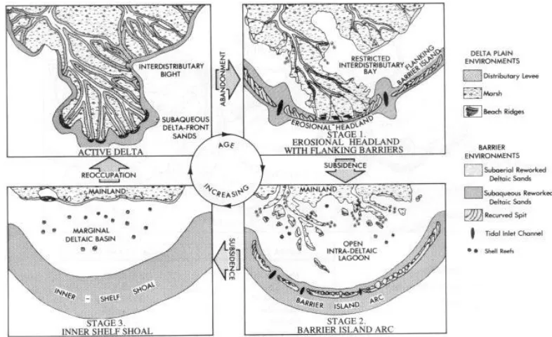
The 3-stage transgressive barrier island model of Penland and Boyd (1981) (Penland and
Boyd, 1981; figure 6) acknowledges the contributions of all three of the earlier models at various stages and levels of influence. They identify shoreline engulfment as the “dominant formative
process for the transition of [the Cailou headland] from Stage 1 to Stage 2” of their model, where
early transgression of the headland results in detachment of flanking barriers and bars from the mainland. Gilbert-type spit growth and de Beaumont-type bar aggradation are considered
secondary contributors to the growth and maintenance of the transgressing islands (Penland and Boyd, 1981).
Beach Ridges
Beach ridges are accretionary features that form on moderate to low energy coasts. Beach
ridges usually occur in sets of successive ridges, usually constructed over decades, forming a beach ridge strandplain (Otvos, 2000; Taylor and Stone, 1996; Tanner, 1995). Beach ridge
strandplains exhibit a ridge and swale geomorphology characterized by sandy, vegetated ridges, often less than meter high, interspersed by swales that can be flooded, intertidal, or subaerial (Otvos, 2000; Taylor and Stone, 1996; Tanner, 1995). Ridge construction provides a mechanism
for shoreline progradation and vertical aggradation of coasts and barriers (Hine, 1979; Otvos, 2000; Rodriguez and Meyer, 2006; Rodriguez et al., 2004; Tanner, 1995; Taylor and Stone,
1996). Beach ridge strandplains form where abundant fine to medium sandy sediment is available in the nearshore swash zone of a shallow, gently sloping shoreface (Otvos, 2000; Tanner, 1995). Straight-crested ridge sets are constructed perpendicular to dominant
shore-normal wave approach, while the ridges formed by longshore transport and recurved spit development exhibit recurved ridge crests (Otvos, 2000).
Ridge formation can be initiated during neap tides, when a sea level is temporarily lowered nearshore berms are exposed (Hine, 1979; Otvos, 2000). The berms aggrade vertically as sediment eroded from the seaward slope of the berm is transported and deposited up the berm
seaward slope face. Lateral aggradation of the berms occurs during higher tides as sediment is transported over the berm crest and deposited down the berm shoreward slope (Hine, 1979).
Over several tidal cycles during extended fair weather periods, the berms aggrade to a permenantly subaerial height. Continued deposition of sediment landward of the berm crest infills the zone between the berm and the previous shoreline, establishing a new, seaward
shoreface, ultimately removing the inland ridges from the nearshore environment. Inland ridges are essentially relict shorelines (2000). Offshore winds enable landward eolian sediment
transport and deposition over the ridges, developing dunes deposits over the ridges (Otovs, 2000; Tanner, 1995). Colonization of ridges and dunes by vegetation enhances ridge stabiity and
preservation (Otvos, 2000; Tanner, 1995).
Due to their low elevation and coastal locations, beach ridge strandplains are vulnerable to erosion from climatic stressors such as storm wave breaching, tidal erosion and sea level rise.
In the northern Gulf of Mexico, however, beach ridge strand plains can be observed at multiple sites along the coast proximal to abundant sediment sources: the Morgan-Perdido strandplain
complex that extends from the eastern headland of Perdido Bay, FL westward to the Morgan Peninsula that juts into Mobile Bay, AL from the eastern bay headland (Otvos and Giardino, 2004; Otvos, 2005 a; Rodriguez and Meyer, 2006); relict beach ridge sets on Point Clear and
Campbell Islands on the eastern margin of the Pearl River, MS estuary (Otvos and Giardino, 2004; Otvos, 2005); and beach ridges on the Bolivar Peninsula and Galveston Island that flank
Galveston Bay, TX (Morton et al., 2000; Rodriguez et al., 2004) are a few examples. As
individual beach ridges form at the land-water interface in response to small-scale changes in sea level, their original elevations are approximate analogues of sea level. Sea level rise histories
derived from beach ridge set elevations (Morton et al., 2000; Tanner, 1992) have disputed, as they do not acount for the eolian deposition that occurs on maturing ridges (Lopez and Rink,
2008; Otvos, 2000; Rodriguez and Meyer, 2006). Elevations and dates of the interface between ridge and dune lithofacies do record the progression of sea level fluctuations (Lopez and Rink, 2008; Rodriguez and Meyer, 2004). Rodriguez and Meyer (2006) used profiles of the Edith
with ground penetrating radar (GPR) to map the interface between the ridge and dune lithofacies (Rodriguez and Meyer, 2006). An overall seaward-increasing elevation of the beach ridge-dune
interface validate a continuous sea level rise to present (Rodriguez and Meyer, 2006). The orientation of beach ridges to each other and to the shoreline is principally
determined by sediment supply and dominant wave approach (Lopez and Rink, 2008; Otvos, 2000; Rodriguez and Meyer, 2006; Rodriguez et al., 2004; Tanner, 1995; Taylor and Stone, 1996). Beach ridge orientation has been used to infer the direction of historical shifts in dominant
incident wave approach intervals (Lopez and Rink, 2008; Otvos, 2000; Rodriguez and Meyer, 2006; Rodriguez et al., 2004; Tanner, 1995; Taylor and Stone, 1996). Abundant sediment supply
is crucial to the development of beach ridge sets, and must be able to sustain the multiple cycles of ridge formation over multi-decadal intervals (Otvos, 2000; Tanner, 1995; Taylor and Stone, 1996). The site of ridge construction is therefore constrained by sediment availability. Timmons
et al. (2008) observed paleochannels in seismic data acquired along Bogue Banks and Pine Knoll barrier shorelines of the Outer Banks, NC at sites corresponding to progradational beach ridge
sets along the otherwise narrow, elongate barrier (Timmons et al., 2008).
Present-day Regional Background and Conditions
The Mississippi Sound is a shallow body of water along the Northern Gulf of Mexico
coast from Mobile Bay, AL to Waveland, MS from east to west, and enclosed by the barrier islands that parallel the mainland 9-19 km offshore. The Sound encompasses an area
approximately 2100 km2 with average depths ranging from 2-5 m, and up to 25 m in the passes and channels. The MS-AL barrier island chain is currently comprised of Dauphin, Petit Bois, Horn, East and West Ship and Cat Islands, from east to west. The barrier trend is fragmented by
west): the Mobile Ship Channel on the eastern side of Dauphin Island, Petit Bois Pass, Horn Island Pass, Dog Keys Pass, and the convergence of Pass Marrianne and Cat Island Pass west of
Cat Island. The Mobile, Pascagoula and Ship Island navigation channels are routinely dredged to maintain depths required for navigation channels (figure 1).
The Mississippi Sound is currently the receiving basin of several major fluvial systems: the Mobile, Pascagoula, Biloxi, Wolf, Jourdan and Pearl Rivers from east to west, as well as smaller tributaries that drain the coastal plain (Boone, 1973; Curray and Moore, 1963;
Isphording et al., 1989). Mobile Bay has the fourth largest average annual discharge in the United States at 79,300 cfs delivering 6.35 million tons of sediment/year (Isphording et al.,
1989). The Pascagoula and Pearl Rivers combined discharge 43,600 cfs and 4.58 million
tons/year (Isphording et al., 1989). The infusion of fresh water results in lower average salinities in the Sound (0 to 30 parts per thousand) than in the open Gulf (30 to 40 parts per thousand) that
support the estuarine biota found there (Boone, 1973). A diurnal, microtidal range of up to 0.6 m (Isphording et al., 1989) transports water from the Gulf through the tidal passes between the
islands, resulting in locally higher salinities (Boone, 1973). The major rivers have been active throughout the Quaternary, delivering weathered sediment of Appalachian provenance, abundant in heavy minerals (Hsu, 1960; Isphording, 1989; Van Andel, 1960).
The transitory nature of this coastal environment is underscored by evidence of former and emerging barrier features. Dog Island was a small islet, part of a string of shoals, Dog Keys,
located to the west of Horn Island in Dog Keys Pass that periodically aggraded and dissipated (Otvos and Carter, 2008). Dog Island had been the site of a military reservation since 1847 (Otvos and Carter, 2008) until a hurricane in 1852 apparently reduced it to a subaqueous shoal,
and Snowden, 1988). An islet re-emerged between 1855 and 1877 at that site (U.S. Coast and Geodetic Survey chart T-4021, 1917), perhaps assisted by the westward migration and
coalescing of smaller shoals directly to the east over the submerged remnant of Dog Island (Otvos and Carter, 2008). The island was re-named the Isle of Caprice and reached up to 2.5 km
in length by 1926 when it was breached by a hurricane (Otvos and Carter, 2008). Segmentation of the island accelerated wave-induced erosion, until its total disappearance in 1939 (Otvos and Carter, 2008). In the 1960’s, along the western margin of Horn Island Pass between Petit Bois
and Horn Islands, a small man-made island emerged as dredge-spoil deposits accelerating construction of an intertidal shoal. By 1971, an island ~400 m in length had formed (Otvos and
Carter, 2008). Continued dredge-spoil deposition has been reworked by tidal and westward littoral currents, constructing recurved spits and ridges, welded on to the original shoal increasing the island’s length to ~1.2 km in 2005 (Otvos and Carter, 2008).
Holocene Evolution of Mississippi Sound
Central and Eastern Mississippi Sound
Several hypotheses for the MS-AL Barrier Islands have been proposed. Shepard (1960 a) suggested, in the absence of substantial headlands to provide sand through erosion, the islands are the product of both local and longshore-transported sediment from the east. Shepard (1960 a)
thought it unlikely for sediment from the major regional fluvial source, the Mobile River to the east, to be carried in sufficient quantities across the shelf to construct the barrier chain, proposing
that offshore shoals formed in situ during shoreline transgression, aggrading into a barrier platform (Shepard, 1960 a). With upward bar growth and rising sea level, however, shelf sediment was submerged below the constructive breaker zone and was no longer available to
necessary to assist in island growth and maintenance (Shepard, 1960 a; Kwon, 1969). Based on a minerologic analysis of barrier beach sands, Foxworth (1962) suggested subaqueous bars sands developed from the eroded and re-worked underlying Pleistocene deposits (Foxworth, 1962).
These Pleistocene sediments originated as deltaic deposits accumulated during the glacial
lowstand, delivered by the fluvial systems of Mississippi and Alabama (Foxworth, 1962). Storms
then provided the necessary energy and temporary rise in sea level to elevate the bars above sea level. Island growth proceeded under fair weather conditions with longshore currents as the predominant source of sediment and geomorphic modification (Foxworth, 1962).
Based on interpretations of seismic and core data from the northern Gulf, Curray and Moore (1963) identified a weathered lowstand horizon, the Pleistocene surface, approximately
6-12 m bsl from east to west, underlying the Sound facies (Curray and Moore, 1963; figure 7), incised by paleochannels associated with relict fluvial networks of the modern Pearl, Wolf, Biloxi and Pascagoula Rivers traversing the inner Mississippi-Alabama continental shelf (Curray
and Moore, 1963). The overlying Sound facies were determined to have originated from alluvium deposited by the local rivers (Curray and Moore, 1963). The rapid early to mid
Holocene transgression precluded delta formation and landward-shifting depocenters first deposited sediment in the accommodation space provided by the paleochannels, and as these
valleys filled, alluvium was distributed across the inner shelf. Winnowing of fines from the
alluvium by the landward migrating wave breaker zone resulted in a coarser-grained basal sand layer that aggraded into offshore shoals, forming the subaqueous barrier platform (Curray and
Moore, 1963). Continual sediment delivery from the Pearl, Pascagoula and Wolf river systems during the late Holocene in addition to the re-worked alluvial deposits provided the material for
barrier island aggradation by shore-normal constructive waves. Seismic transects between Cat and Ship Islands and Ship and Horn Islands showed a sandy ridge ~9 - ~12 m bsl thick on strike with the islands (Curray and Moore, 1963; figure 7), suggesting a continuous sandy lithosome,
possibly an earlier-stage barrier, underlying the length of the barrier chain, grading laterally into the basal, or barrier platform sands of the modern islands. The base of the sands superimposes a
unit of marine clays over Pleistocene clays. Correlating the depth of the layer with the Curray (1960) sea level curve, Curray and Moore (1963) proposed that the underlying, then-continuous ridge began forming ~7000 ybp. Vertical and seaward growth via a “depositional regression”
was facilitated by abundant underlying sediment and a slowing rate of sea level rise. Breaching by inlets subsequently developed widening channels segmenting the ridge resulting in the
contemporary chain of islands (Curray and Moore, 1963).
Otvos and Giardino (2004) proposed an evolutionary model for the Mississippi Sound that incorporates ridge engulfment in the eastern Sound and an emergent bar model in the central
Sound. In the central Mississippi Sound the underlying barrier island platform was constructed by nearshore sediment aggradation over muddy-sandy Holocene nearshore deposits (Otvos,
1981, 1985 a, 1985 b, 2005 a; Otvos and Giardino, 2004). This interpretation was supported by core interpretations showing increased sorting and decreased silt and clay concentrations upward in the 3-12 m thick muddy, brackish Holocene layer (Otvos, 1981, 1985 a, 1985 b, 2005 a) with
b). Over the muddy layer lies the barrier platform, composed of 7-12 m of poorly- to moderately-sorted sandy-to-muddy deposits with few fauna (Otvos, 1985 a, 1985 b). Interspersed lenses of
moderate to well-sorted sands in this unit were interpreted as transient intertidal shoals (Otvos, 1981). The stabilizing barrier platform began to enclose the Sound, protecting the backbarrier
environment from the high-energy waves of the open Gulf. Transition to a restricted bay hydrodynamic regime allowed fine-grained sediment to settle and accumulate as lagoonal-type facies. A low-salinity nearshore marine environment had been maintained by high levels of
freshwater influx from estuaries along the mainland prior to the enclosing of the Sound and was reinforced by the newly restricted exchange with the open Gulf waters, explaining the absence of
open marine fauna (Otvos, 1985 b, 2005 a; Otvos and Giardino, 2004).
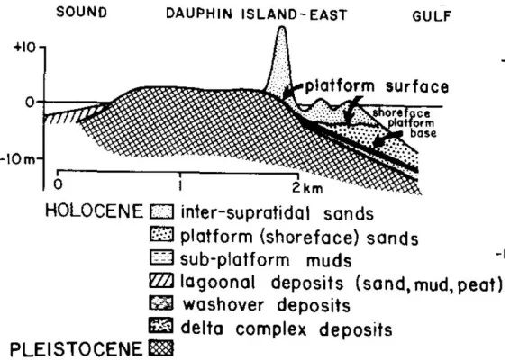
In the eastern Sound, Dauphin Island illustrates the control of the original geologic structure over geomorphic evolution, exhibiting the stratigraphic sequence of a composite barrier
island (Otvos, 1979, 1985 a, 2005 a). The intervening Holocene mud unit is absent, and the underlying Pleistocene deposits form the base of the island’s core and are exposed as the
subaerial island surface approximately 2 m above sea level (Otvos, 1979, 1985 a, 2005 a). The sandy barrier platform is presented on the Gulf side of the island onlapping the Pleistocene core and forming a foundation for the intertidal shoreface deposits surface. On the landward side,
lagoonal deposits pinch out on to the Pleistocene base (Otvos, 1981, 1985 a, 2005 a) (figure 8). Material for Dauphin Island’s barrier platform originates at the eroding Morgan Peninsula that
extends from the eastern margin of the Mobile Bay headland toward Dauphin Island, and the Mobile Bay ebb tidal delta (Otvos, 1981, 2005 a). Locally reduced tidal currents enable settling of entrained sediment that coalesces around the semi-consolidated core. With sustained,
island prograded seaward through the development of a beach ridge strandplain and westward, as longshore currents transported sand from the western tip of the island to the eastern terminus
forming a long, thin subtidal barrier platform (Morton, 2008; Otvos, 2005 a). The prevailing east-to-west longshore currents “had a primary influence on the vertical aggradation of the platform” (Otvos, 1981, 1985 a, 1985 b, 2005 a) and presumably carried sediment across the
length of the Mississippi Sound, providing sediment to the downdrift aggrading shoals and emerging barriers (Otvos, 1981, 1985 a, 2005 a). Beach ridge strand plains on Dauphin and Cat
Islands and relict ridges on Horn and Petit Bois Islands attest to a substantial volume of sediment delivered to the Mississippi Sound barriers during the late Holocene (Otvos, 1985 a; Otvos and Giardino, 2004; Rucker and Snowden, 1989, 1990).
Western Mississippi Sound
Discovery of a series of sandy barrier island deposits, the Pine Island Barrier trend, buried under deltaic sediments along the southern shoreline of Lake Pontchartrain led to a hypothesis of Cat Island’s formation (Flocks, 2009; Otvos, 1978, 2005 a; Otvos and Giardino,
2004). The Pine Island barrier trend was first identified and mapped by Treadwell (1955), who
described them as a band of “cheniers” (Treadwell, 1955). Cores taken from the New Orleans
barrier showed a quartzose sandy lithosome, 10-11 m thick, resting entirely within prodelta silts
and clays, protruding slightly into an overlying peaty marsh layer (Corbeille, 1962; Saucier, 1963; Treadwell, 1955). The Pleistocene surface in adjacent drillcore sites was found at ~13.5 m
and ~14.4 m below the land surface (Treadwell, 1955). The barrier was interpreted to be a relict former shoreline, based on the high degree of sorting and moderate grain size, and of similar mineralogy to the Eastern Gulf Province (Corbielle, 1962; Treadwell, 1955; Saucier, 1963). The
barriers were estimated to have formed contemporaneously with the Mississippi River Margouin and Teche delta phases ~7000 - ~4000 ybp (Corbielle, 1962). Further investigation constrained
the initiation of the Pine Island trend to between ~5300 - ~4400 ybp (Otvos, 1978). Although the Pine Island and Cat Island barriers likely formed at the same time, the buried Pine Island
lithosomes gave older dates as the sediments had been preserved from reworking and
uncontaminated by later sedimentation (Otvos and Giardino, 2004). Otvos (1978) also surmised that deposition occurred in a subtidal environment, as the coarse grain size and lack of subaerial
dune morphology and internal cross-bedded strata are indicative of offshore shoals rather than stabilized barrier islands (Otvos, 1978).
At ~7000 ybp, the Mississippi River began prograding westward out over the
newly-submerged Pleistocene surface, while the Pontchartrain Basin remained an open bay maintaining a high-salinity environment that supported oysters and other saline-tolerant fauna (Saucier, 1963;
Otvos, 1978). As sea level rise slowed and shorelines stabilized, at around ~5000 - ~4600 ybp, transgressive offshore shoals began to aggrade, supplied with sediment re-worked and
transported from the inner shelf as well as by fluvial sediment carried by the rivers emptying into
vicinity of the Pontchartrain Basin may have proceeded more slowly than along the adjacent coast, as the faulting in that area created a zone where the slope was steeper, favoring shoal
aggradation into stable barrier islands (Saucier, 1963). A hypothesized brief fluctuation in sea level at ~4100 ybp may have allowed for barrier stabilization as sea level fell, then for continued
onshore transport of sediment as transgression resumed (Stapor and Stone, 2004). Prevailing east-west longshore currents in the northern Gulf provided delivered sediment and helped shaped
As the St. Bernard delta lobe prograded eastward, deltaic plain and pro-deltaic marshland were constructed in the formerly open waters of the eastern Mississippi Sound, halting and
re-directing the westward flowing longshore current. Otvos and Giardino’s conceptual model of barrier island chain and associated delta plain development shows the St. Bernard delta lobe
reaching its maximum extent at ~2000 ybp (Otvos and Giardino, 2004; figure 9). Its fringing marshes stranded the Hancock County barriers along the mainland, and its easternmost shoreline reached beyond the present location of the Chandeleur Islands, southeast of Cat Island (Otvos,
2005 a; Otvos and Giardano, 2004). As the eastern shoreline of Louisiana prograded, westward flow of the northern Gulf and Mississippi Sound was obstructed and longshore currents
decelerated as they approached Cat Island. Prodelta deposition shallowed the waters around Cat Island, transforming the hydrodynamic regime from open marine to low-energy nearshore and re-directing the dominant wave approach to the island’s southeast shoreline (Rucker and
Snowden, 1989; 1990). At this stage, Cat Island retained its original elongate, mainland-parallel configuration (Otvos and Giardino, 2004; Otvos, 2005 a). Analysis of sediment retrieved from a
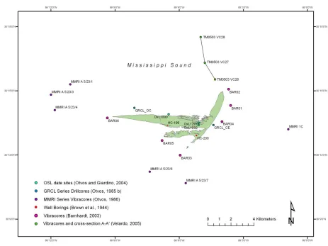
vibracore south of the present-day N-S spit (core BAR03, Barnhardt, 2003; figure 10) confirms the extension of the St. Bernard delta complex to this position (Barnhardt, 2003). The upper 0.45 m of the core contained quartz sand, moderately to well sorted and fining with depth, and was
interpreted as sediment eroded and transported from the original eastern island terminus
(Barnhardt, 2003). The lower core, from ~0.45 - ~0.75 m bsf was composed of clays and sands,
By ~2900 to ~2600 ybp, the incipient barriers south of Lake Pontchartrain were
completely stranded and buried (Otvos and Giardino, 2004). The Hancock County, MS barriers
further to the west (Pine Island, Point Clear and Campbell Island) outcropped a few feet above the surrounding marsh surface (Treadwell, 1955; Saucier, 1963; Otvos, 1978; Otvos and
Giardino, 2004). The St. Bernard delta was abandoned at ~1800 ybp and entered its destructive phase at ~1000 ybp (Frazier, 1967; Penland et al, 1989) as the Mississippi River changed course. Sediment delivery from the Mississippi River was drastically reduced, and transgressing Gulf
waters eroded the subsiding delta, re-opening the pass between Cat Island and the Louisiana
coast. Wave approach was then confined to a 25˚ window southeast of the island, focusing erosion on its eastern tip (Rucker and Snowden, 1989, 1990).
As the large volumes of material sequestered in Cat Island’s extensive beach ridge plain
eroded, the sediment was immediately re-deposited in the shallowing waters over the island
platform, developing the north-south spit. The upper sandy unit of core BAR03 (Barnhardt, 2003; figure 10) originated from the eroded eastern end of the island as the St. Bernard Delta lobe receded and the area reverted to a high-energy nearshore regime (Barnhardt, 2003). During
this transition from a lower to higher energy environment, the original deltaic and barrier sands were re-worked and re-deposited as the mixed sedimentary unit superimposing the deltaic
deposits in lower core BAR03 (Barnhardt, 2003; figure 10). The coarsening upwards of the barrier sands in upper core 03 also indicates a transition to a higher energy environment (Barnhardt, 2003). A series of three vibracores taken in the Mississippi Sound northwest of the
N-S spit (cores TM-VC28, TM-VC27, TM-VC26, Velardo, 2001; figure 10) revealed a mud-over-sand to sand-over-mud progression toward the island and is interpreted as a depositional
sequence initiated by the transition from an open-water, high-energy environment to the present-day reduced energy environment on the lee side of Cat Island’s N-S spit. The basal sandy units in
cores TM-VC28 and TM-VC27 were deposited prior to disruption of the high-energy open
marine environment to the west and the longshore currents in the Mississippi Sound that prevented fine grains from settling. As the spit prograded into the Sound, low energy waters
behind the spit allowed fine sediment deposition, forming the muddy unit over the sand. The upper sandy facies present at core TM-VC26 likely indicate the distal edge of the N-S spit platform prograding over the muddy unit. The accumulation rate of 0.2 cm/year calculated for
ybp and approximately 500 ybp-700 ybp after the abandonment of the St. Bernard Delta, based on the conceptual model proposed by Otvos and Giardino (2004) (Velardo, 2005).
Present-day Geomorphology of Cat Island
Cat Island, MS is located at the western perimeter of the Mississippi Sound
approximately 12 km south of the Mississippi mainland. The westernmost marsh fringe of Louisiana’s relict St. Bernard delta complex lies roughly 10 km to the east, across the
Chandeleur Sound (figure 1). The island consists of two east-west trending, vegetated segments
separated by a narrow lagoon. The larger segment is the main remnant of the original island, currently measuring 7 km from the western tip (West Point) to the eastern shoreface, and 1 km
across at its widest point tapering to the west (figure 11). A north-south trending sandy spit 5 km
Figure 11. USGS aerial photography of Cat Island, MS acquired on June 29, 2007 showing present-day