Sokolov Oleksandr, Mreła Aleksandra, Józefowicz Mateusz, Rydel Krzysztof, Meszyński Sebastian. Positioning a mobile robot in a closed area with a map of markers. Journal of Education, Health and Sport. 2019;9(4):573-579. eISSN 2391-8306. DOI http://dx.doi.org/10.5281/zenodo.2653280
http://ojs.ukw.edu.pl/index.php/johs/article/view/6868
The journal has had 7 points in Ministry of Science and Higher Education parametric evaluation. Part B item 1223 (26/01/2017). 1223 Journal of Education, Health and Sport eISSN 2391-8306 7
© The Authors 2019;
This article is published with open access at Licensee Open Journal Systems of Kazimierz Wielki University in Bydgoszcz, Poland
Open Access. This article is distributed under the terms of the Creative Commons Attribution Noncommercial License which permits any noncommercial use, distribution, and reproduction in any medium, provided the original author (s) and source are credited. This is an open access article licensed under the terms of the Creative Commons Attribution Non commercial license Share alike.
(http://creativecommons.org/licenses/by-nc-sa/4.0/) which permits unrestricted, non commercial use, distribution and reproduction in any medium, provided the work is properly cited.
The authors declare that there is no conflict of interests regarding the publication of this paper.
Received: 15.04.2019. Revised: 25.04.2019. Accepted: 29.04.2019.
POSITIONING A MOBILE ROBOT IN A CLOSED AREA WITH A MAP OF MARKERS
Oleksandr Sokolov
Faculty of Physics, Astronomy and Informatics Nicolaus Copernicus University, Toruń, Poland
Aleksandra Mreła Faculty of Technology
Kujawy and Pomorze University, Bydgoszcz, Poland [email protected]
Mateusz Józefowicz
ABM Space Sp. z o.o., Toruń, Poland [email protected]
Krzysztof Rydel
ABM Space Sp. z o.o., Toruń, Poland [email protected]
Sebastian Meszyński
Abstract
The article presents issues related to the positioning of mobile robots in a closed area. The method of positioning using photogrammetry methods based on the analysis of specially created unique square-shaped markers is presented. On the basis on such markers placed in the global coordinate system in a closed space (on the terrain ceiling), the proposed algorithms for calculating the spatial and angular positions of the robot are shown. The positioning methods along with the analysis of measurement errors are analyzed. The result of the research is to develop a real-time robot navigation method in the ReMY simulation game.
Key Words: mobile robot positioning, camera calibration, map of markers, ReMY simulation game
Introduction. An essential condition for the quality of any task performed by a mobile robot is the accuracy of its positioning. Depending on the environment in which the robot operates, various sources of information about its positioning can be used [4]. The most frequently used ones include autonomous radars, sonars, and scanners, working on an area, systems using distance and signal angle measurement, image analysis systems or proximity detectors, global positioning systems [3] and [7]. In the conditions of the enclosed area, the most suitable for the practical implementation of positioning issues were vision systems, i.e., cameras, based on a computer vision [11] and photogrammetry methods [8].
sending a large amount of video data to the external network (for analyzing) and receiving data after processing. In this case, this kind of data transmission also involves a correspondingly large power consumption. Therefore, we are currently seeking to develop an algorithm that minimizes the data necessary to analyze and generates a stable and precise response.
(a) (b) (c)
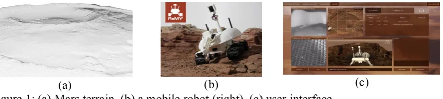
Figure 1: (a) Mars terrain, (b) a mobile robot (right), (c) user interface
Remote Mars Yard, ReMY, is a simulation system of a simple Martian mission consisting of virtual and real components [10]. The ReMY environment uses the proposed positioning algorithms. The real component is a mobile robot - a 40-centimeter six-wheel platform controlled by WiFi, made in 3D printing technology, equipped with two functional cameras (scientific and navigational), one positioning camera, a camera arm that simulates the manipulator and a mast allowing navigation camera motion (the positioning camera is stationary), as well as a Martian scale mock-up (Fig. 1 (a), (b)) measuring 3 x 4 m (in the extension, there are four mock-ups 10 x 10 m), containing some of the reflected objects of interest.
The virtual component is a user interface software (Fig.1 (c)) in the web browser (in the development version for download) and virtual robot instruments and functions, as well as virtual map layers with virtual objects of interest connected to the task database and their descriptions. The user interface includes streaming from navigation and scientific camera (and an additional lander-base camera), telemetry, scenario messages and robot location visualization on a virtual map. The ReMY system designed as a game for an educational, group or individual, player, can also be used to develop navigational techniques, operating procedures, robot mobility, and other research areas. The system uses the experience gained in the project of navigating the lander and Mars mobile robot WIMR implemented for ESA as part of the Polish Industry Incentive Scheme.
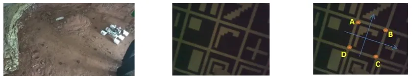
[image:3.595.86.521.146.244.2]Figure 2 (a) The area of the mobile robot, (b) markers on the ceiling, (c) the photo with coordinates on the marker
The mobile robot calculates its positions in the global XYZ system, placed in the corner of the ceiling based on the taken photo and the reference of its position according to the markers visible in the picture. One of the possible tasks is to rebuild the mobile robot's path based on a series of photos. Of course, the accuracy of the position calculation depends on several necessary procedures, adapted from the methods of photogrammetry – camera calibration and calculating the relative position of objects in the area (the mobile robot's camera and marker) based on photos. In this article, the procedures and possible errors that arise during the application of photogrammetric methods will be the objects of analysis.
Positioning based on markers. With a marker layout with known coordinates, placed on the ceiling, a positioning algorithm that relies on projective image transformations can be proposed [9]. At the input of the algorithm, a calibration matrix and intrinsic parameters of the camera obtained at the calibration stage are given. Positioning is done using the photo (Fig. 2(c)) in which the coordinates of the marker’ corners obtained using unique recognition algorithms, for example, SURF [2], and the markers shapes are fully recognized. Hence, each point X in real space (global XYZ system) is mapped to the point in the photo xapplying homogeneous coordinates [6]
x = KR [I3|-T]X = P X (1)
where K=
[
cx 0 xH
0 cy yH
0 0 1
]
is the calibration matrix, Ris the camera rotation matrix, T is the
translation (displacement) vector of the camera in the global XYZ system and P=
[
p1, p2, p3]
, where pi, i=1 ,2 ,3 ,4, are columns of matrix P.For positioning based on the points in the photo, we do a projection transformation of the points from this photo with the appropriate spots on the virtual image that would supposedly be done in the vertical camera position just at the center of the square (Fig. 3).
Figure 3. Photos for positioning: virtual (left) and real (right)
[image:4.595.84.506.68.146.2]example, for a point on the ceiling with coordinates (X, Y, 0), a calibration matrix K and
R=I3, T=[0,0, Z¿]' applying (1), we get
x¿−x
H=−cx
X Z¿
, y¿−y
H=−cy
Y
Z¿ (2)
Let the coordinates (x , y) correspond with the real image coordinates (x¿, y¿) for points A, B, C, D (Fig. 2 (c)). For both photos, we create a projection transformation (Fig. 4 (a)):
x−xH= a1(x
¿−x
H)+a2(y
¿−y
H)+a3
a7(x¿−xH)+a8(y¿−yH)+1 , y−yH=
a4(x¿−xH)+a5(y¿−yH)+a6
a7(x¿−xH)+a8(y¿−yH)+1 (3)
To calculate the coefficients a1, …, a8of the projection transformation in (3) we need at least 4 points, creating a system of algebraic equations. For calibration matrix K , R=[rij],
T=[Tx, Ty, Tz] and X=[X , Y,0 ,1]', we get
x−xH=cxr11X+r12Y−Tx r31X+r32Y−Tz
, y−yH=cxr21X+r22Y−Ty r31X+r32Y−Tz
(4)
where matrices R and T are unknown. When comparing (3) and (4) and taking into account (2), it can be concluded that
r11=Tz
Z¿a1, r12= Tz
Z¿a2, r21= Tz
Z¿a4, r22= Tz
Z¿a5, cx=
Tz Tx
a3, cy=Tz
Ty
a3 (5)
The rotation matrix R is known to be orthogonal with a determinant equal to 1, so there are more equalities: r112 +r212 +r312=1, r122 +r222 +r322 =1.
Hence,
r12i
(
Z¿Tz
)
2+r22i
(
Z¿Tz
)
2+r32i
(
Z¿Tz
)
2=
(
Z¿Tz
)
2, for i=1 ,2. (6)
Comparing (5) with (6), we get a1 2
+a4 2
+a7 2
cx
2
=
(
Z¿Tz
)
2, a2 2
+a5 2
+a8 2
cy
2
=
(
Z¿Tz
)
2.
Put
h=
√
a12+a24+a72c2x=√
a22+a52+a82c2y=|
Z¿
Tz
|
(7)From equations (7), it is possible to calculate the unknown elements of the rotation matrix (taking into account that the values have the same sign because the mobile robot is on one
side from the ceiling), so r11=a1 h , r12=
a2 h , r21=
a4 h , r22=
a5
h ,r31=cx
a7
h , r32=cy
a8 h .
The properties of the rotation matrix show that
r13=
|
r21 r22 r31 r32
|
,r23=
|
r11 r12 r31 r32
|
,r33=
|
r11 r22
Applying (5) we have Tz=
Z¿ h ,Tx=
Tza3 cx
=Z¿a3 h cx
, Ty=
Tza6 cy
=Z¿a6 h cy
.
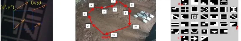
Results. The experiment aims to determine the position of the mobile robot using a set of markers (see Fig. 4 (b). In Fig. 4 (c), there are 11 points where their positions were measured. The reference position calculations were also made using a laser rangefinder.
Figure 4 (a) Projection transformation, (b) numeration of points on the area, (c) numeration of markers on the ceiling and points A, B, C.
During the movement of the mobile robot, the algorithm correctly detects the point at different angles of its position. For a distance of around 2m, the position assessment was calculated in a 10cm x10cm square with pixel error ±2. Further research will involve improving the efficiency of determining the position of the robot using artificial intelligence methods.
Conclusion. The article proposes a solution to the problem of positioning a mobile robot that fulfills navigational missions in a closed area. A set of markers arranged on the ceiling was used for the positioning evaluation. The position and rotation of the robot are evaluated in a global coordinate system, connected to markers. A calibration and positioning algorithm based on marker images was proposed. This algorithm is based on a reference (virtual) photo and enables connecting the robot's system to the global XYZ system with the help of a set of markers on the ceiling.
Acknowledgement. This paper was based on the research project “ReMY – Remote Mars
Yard” as part of Smart Growth Operational Programme 2014-2020, co-financed by the European Regional Development Fund Priority Axis I: Supporting R&D carried out by enterprises, Measure 1.2: Sectoral R&D Programmes. Applications for additional funding: POIR.01.02.00-00-0113/16.
References
1. Baggio D.L., (2011), Mastering OpenCV with Pract. Comp. Vision Projects, Packt Publish.
2. Bay H., Tuytelaars T., Van Gool L., (2002), SURF: Speeded up robust features, In ECCV.
3. Borenstein J., Everett H. R., Feng L. and Wehe D., (1997), Mobile Robot Positioning -Sensors and Techniques, Journal of Robotic Systems, Vol. 14, No. 4, pp. 231-249. 4. Bouguet J.Y., (1998), Camera Calibration from Points and Lines in Dual-Space
Geometry - Technical Report, ECCV.
5. Bradski G., Kaebler, (2008), Learn. OpenCV Comp. Vision with the OpenCV, Lib. O'Leary.
[image:6.595.101.510.163.234.2]7. Guzik P., (2014), Metody wyszukiwania punktów charakterystycznych i wyznaczania ich cech, Wydz. Elektroniki i Technik Informac. Politechniki Warszawskiej, Inst. Informatyki.
8. Kraus K., (2007), Photogrammetry, De Guyter.
9. Lebiediev D., Tkachenko A. (2006), Navigation and orientation control of small spacecraft, Kijv, Naukova Dumka.
10. ReMY, (2018), https://remotemarsyard.com/Home/Index/home, access: 18.09.2018.