Analysis of Tree Damage Caused by Rockfall at Forest Road Construction Works (p.151-158)
8
0
0
Full text
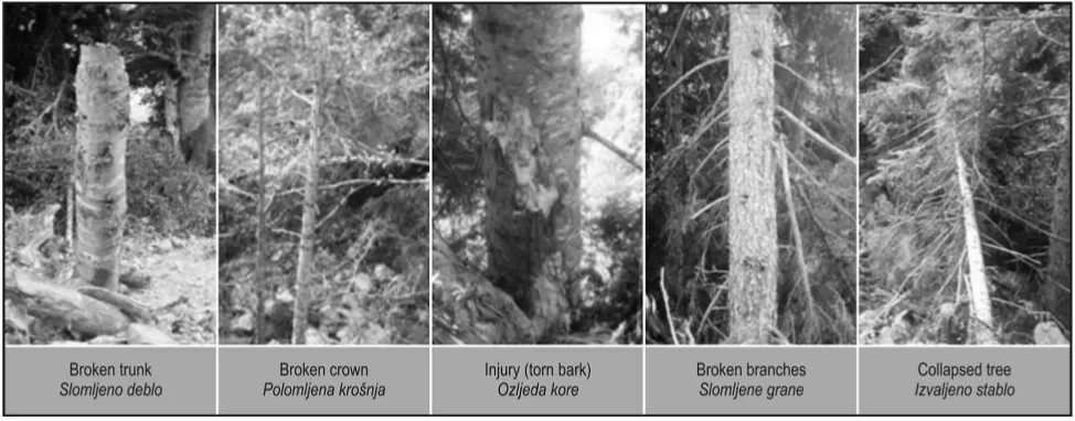
(2) S. Gumus et al.. Analysis of Tree Damage Caused by Rockfall at Forest Road Construction Works (151–158). 2. Rockfall and tree damage – Odroni i o{te}enja stabala. Fig. 1 General modes of motion of rocks during their descent on slopes in relation to mean slope gradients Slika 1. Op}eniti na~ini kretanja stijenja pri kotrljanju niz padinu s obzirom na prosje~ni nagib terena There has been no comprehensive study about the effects of rockfall on forest trees as a result of forest road construction. Construction works have a significant adverse effect on forest trees because of the rockfall they create. This effect mostly appears in the form of tree damage. The aim of this study is to analyze tree damage occurring during forest road construction.. After the rock has been detached and starts to move, it descends the slope in different modes of motion. These modes of motion strongly depend on the mean slope gradient (Fig.1). The three most important modes of motion are freefall through the air, bouncing on the slope surface and rolling over the slope surface. Freefall occurs if the slope gradient below the potential falling rocks exceeds 76°, but in different field situations this value varies. Fig. 1 shows that around 70° the motion of the rock gradually transforms from bouncing to falling (Dorren 2003). Forest road constructions produce many rock pieces. If these rock pieces are not carefully placed on the embankment slope, they roll down it. This situation is unavoidable during bulldozer digging or blasting of rock mass. Stone and rockfalls cause tree damage such as torn bark, collapse, broken branches – crown – trunk. Fig. 2 shows samples of such tree damage.. 3. Materials and methods – Materijali i metode 3.1. Materials – Materijali This study has been made throughout 3,100 m of forest road construction area in the Gumushane (Kurtun region of Turkey). The road started at 510,050 m, 4,511,145 m coordinates at UTM projection system with ED 50 datum in 37 T square and ended at 510,375 m, 4,510,865 m point location. The. Fig. 2 Samples of tree damage in study area Slika 2. Primjeri o{te}enja na stablima na istra`ivanom podru~ju 152. Croat. j. for. eng. 30(2009)2.
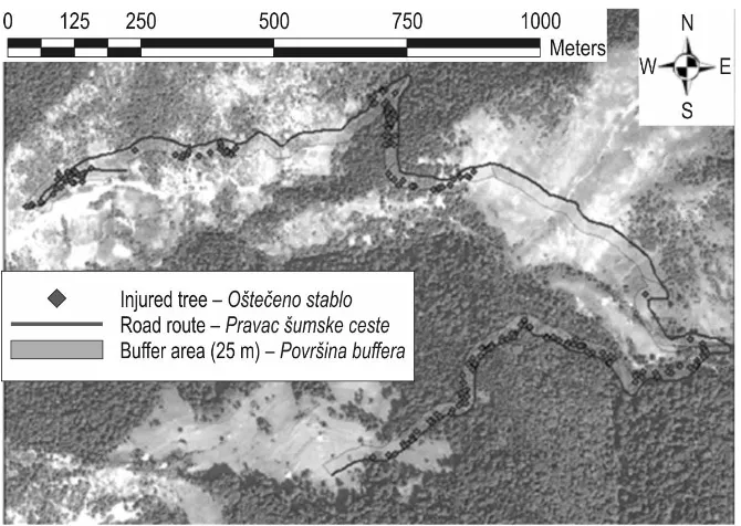
(3) Analysis of Tree Damage Caused by Rockfall at Forest Road Construction Works (151–158). study area predominantly contains Quercus petraea (Matt.) Liebl. Subsp. iberica (stwen ex M.Beieb.) Krassiln, and Picea orientalis (L.) Link, and other species such as Pinus sylvestris L., Fagus orientalis Lipsky, and Alnus glutinosa (L.) Gaertn. Supsp. barbata (C.A.Mey.) Yalt. There is no forest cover for 0 – 100, 295–475 and 1,390–2,075 meters of the road section under consideration. According to the measurement results, the average diameter and height of trees is as follows: Quercus petraea 15 cm and 6 m, respectively, Picea orientalis 21 cm and 12 m, Fagus orientalis 29 cm and 18 m, Alnus glunitosa 26 cm and 12 m and Pinus sylvestris 36 cm and 20 m. The road route has three different types of forest stand. Quercus forests have Pinus trees as well. Quercus forests are of low density (less than 10% canopy) and approximately 100 years of age. The main parts of the road section are covered by Fagus forest with Picea and Abies species in low proportions. Fagus forest cover has 40–70% of canopy degrees on forest lands. The forest age is approximately 100 year. Both Quercus and Fagus forests have not any shrubs on the floor. The average slope gradient is 75% throughout the constructed road. The study area is classified as 5th class (>70%) very steeply sloping land according to terrain stability class (B.C. Ministry of Forests 1999). This class has been identified as high likelihood of landslides from timber harvesting or road. S. Gumus et al.. construction area by Schwab and Geertsema (Schwab and Geertsema 2009). Excavators and bulldozers were used during road construction. Rocks were blasted with dynamite between 1,015 and 1,182 meters. Tape measure, caliper, height meter and GPS have been used for measurement of the area. Measurement data, standard topographic map with 1/25,000 scale, satellite image, ESRI ArcGIS software and SPSS statistical software have been used to create a database.. 3.2. Methods – Metode Tree and site feature measurements have been made to determine and analyze the damage caused by a rockfall. Two hundred and ninety-five damaged trees have been numbered and their type of damage has been determined. Distribution by damage type, relation to construction techniques (excavator – bulldozer, blasting) and the effect of positional values of damaged trees have been investigated by means of the data collected. In the study area, the following features have been measured and recorded: species of damaged trees, diameter and height of trees, whether the tree has fallen or not, impact on bark or otherwise, whether the impact is on the side or front, whether there are broken branches – trunk – crown, the height of the main injury, location of injury, UTM coordinates of damaged trees.. Fig. 3 Damage to trees and its geographical disturbance Slika 3. Zemljopisni prikaz {teta na drve}u Croat. j. for. eng. 30(2009)2. 153.
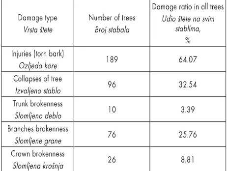
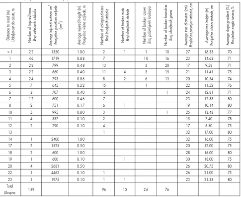
(4) S. Gumus et al.. Analysis of Tree Damage Caused by Rockfall at Forest Road Construction Works (151–158). Geographical information systems (GIS) and remote sensing databases have been used to determine the positional values of the measured trees. While positional information of the damaged trees has been obtained by GPS, satellite images have been combined with data that have been created on GIS. Consequently, information was obtained about the distance between the road and trees, and values of slopes and width of the construction area (Fig. 3). Spot image (2.5 m resolution, May 2006) has been used to determine the construction area. A digital elevation model (DEM) was prepared in GIS database for calculating the gradient of the area. The relation between damage to trees in stands remaining after construction and the reason for the damage has been examined with the help of this study. For this purpose, the following parameters have been determined: frequency distribution of the damage type, distance between tree and road and construction techniques. The relationship between damaged trees’ distance from road, injury status, fallen, broken branches – crown – trunk situation and the relationship diameter of trees, height of trees and side gradient were tested by independent t test. Consequently, a statistical decision was made according to the accepted hypothesis evaluation of t statistic and significance levels. The relations between rock crash type, side – front – graze, to remaining trees and height-width of main injuries were determined by the correlation analysis. The correlation displayed p<0.05 at significance levels (Ozdamar 2004).. 4. Results – Rezultati Two hundred and ninety-five damaged trees have been identified throughout the 3,100 m of forest road construction area. Table 1 shows the type of damage, the number of trees and ratio of distribution. The measurement of injury has not been made for trees, which have fallen or whose bark has been torn. Several trees have broken branches and crown. It has been determined that 90.48% of injured trees are in the first 10 m after the beginning of the embankment slope. Weighted average of the injured surface area on these trees has been calculated as 1,081 cm2. Specific measurements also show as follows: the average height of the injured area is 56 cm, the average diameter of trees is 22 cm, the average tree height is 12 m, and the average slope gradient is 74% (Table 2). It has been determined that tree collapse and fractured branches – trunk – crown are effective for the first 10 m, like the injury area. The rest of the trees are positioned between 11 m and 23 m from the beginning of the embankment. 154. Table 1 The distribution of tree damage Tablica 1. Raspodjela o{te}enja na stablima Damage type Vrsta {tete Injuries (torn bark) Ozljeda kore Collapses of tree Izvaljeno stablo Trunk brokenness Slomljeno deblo Branches brokenness Slomljene grane Crown brokenness Slomljena kro{nja. Number of trees Broj stabala. Damage ratio in all trees Udio {tete na svim stablima, %. 189. 64.07. 96. 32.54. 10. 3.39. 76. 25.76. 26. 8.81. slope. Weighted average of the injured surface area on these trees has been calculated as 1,463 cm2. The average height of the injured area is 30 cm, the average diameter of trees is 24 cm, the average tree height is 15 m, and the average slope gradient is 77%. Broken branches were determined for 16 (34%) of 47 measured trees and 6 (12%) trees had crown damage between 1,015 and 1,182 m of the road. Blasting by dynamite for rock excavation was used as a road construction technique at this section of the studied road. There is 1 (2%) tree that has two injuries. Forty-eight (19%) of 248 trees have broken branches and 20 (8%) trees have broken crowns on other parts of the road where excavator and bulldozers were used for rock and soil excavation. Twelve (5%) trees suffered both types of damage. Variables of damage effect were obtained by statistical relationship after determination of damage frequency. When the fallen trees’ diameter, height, distance to road and slope gradient were compared, according to a non-equal variance t Test (t=6.47, sd=291.30, p=0.000ns), the average distance of fallen and remaining trees to roads was different, with p<0.05 significance level. In other words, the distances of trees to roadside are significant in felling of trees. The diameter, height, distance to roadside and slope gradient of broken-trunk trees and remaining trees were evaluated. According to an equal variance t test (t=2.83, sd=294, p=0.005ns), the average tree height of broken-trunk and remaining trees are not the same, with significance level (p<0.05). It is fair to say that, according to the results, small trees are more affected than larger trees. The other factors are not effective on trunk fracture at p<0.05 signifiCroat. j. for. eng. 30(2009)2.
(5) Analysis of Tree Damage Caused by Rockfall at Forest Road Construction Works (151–158). S. Gumus et al.. Distance to road (m) Udaljenost do ceste, m. Number of Injured trees Broj o{te}enih stabala. Average injured surface cm2 Prosje~na povr{ina ozljede (cm2). Average injured height (m) Prosje~na visina ozljede, m. Number of collapsed trees Broj izvaljenih stabala. Number of broken trunk Broj slomljenih debala. Number of broken crown Broj polomljenih kro{anja. Number of broken branches Broj slomljenih grana. Average tree diameter (cm) Prosje~an promjer stabala, cm. Average tree height (m) Prosje~na visina stabala, cm. Average slope gradient (%) Prosje~an nagib terena, %. Table 2 Frequency distribution and features of damaged trees according to distance to road Tablica 2. Raspodjela u~estalosti i obilje`ja {tete na stablima u ovisnosti o udaljenosti od ceste. <1 1 2 3 4 5 6 7 8 10 11 12 13 14 17 18 19 20 22 23 Total Ukupno. 22 46 28 22 24 7 3 12 2 5 4 2. 1350 1719 799 660 793 645 707 600 751 995 337 290. 1.00 0.88 0.48 0.40 0.86 0.22 0.40 0.46 0.17 0.80 0.10 0.10. 2 7 13 11 8 15 15 7 6 3 2 4 1. 1. 1 10 3 5 6 1. 10 16 20 15 13. 1 2 2 1 4 1 1. 2400 1525 600 600 2681 4462 1975. 1.00 0.50 1.00 0.10 0.50 0.10 0.10. 27 23 17 21 20 22 24 23 19 25 15 17 32 32 20 28 30 26 26 23. 16.33 14.63 9.58 11.41 10.54 11.52 12.81 12.33 10.14 13.43 7.40 8.50 17.00 16.00 12.00 16.00 18.00 20.75 21.00 21.33. 70 71 71 75 74 76 71 80 80 77 78 75 80 75 75 80 75 80 75 80. 189. 1 1 1. 1 1 1. 1. 96. 10. cance level. No correlation was obtained between trunk breaking and tree diameter, and however, it can be assumed that small trees have lower diameter than larger trees. When trees with broken branches were examined according to the variables, the variance of average slope gradient of trees with broken branches and remaining trees was not equal (t=2.017, sd=108.17, p=0.046ns). The average slope gradient affects branch fracture. On the other hand, there is no significant relation between tree diameter, height and distance to roadside and branch fracture at p<0.05 significance level. The variance of average tree height between the broken crown and remaining trees is not equal (t=6.37, sd=52.06, p=0.000ns). The other variables have no effect on broken crown at p<0.05 signifiCroat. j. for. eng. 30(2009)2. 4 2. 26. 76. cance level. Small trees have a broken crown more often. This has been especially observed on road segments where dynamite blasting was used for rock excavations. Blasted rock pieces hit the crowns of small trees and damaged them. A comparison was made between height and width of the main injury and impact of rocks and stones with grazing, side and front hit, and build-up of stones and pieces of rock. There is no statistical relation at p>0.05 significance level. The width and height of the main injury do not depend on the impact style of the rocks.. 5. Discussion – Rasprava The objective of this investigation is to define tree damage, analyze the relations between the occur-. 155.
(6) S. Gumus et al.. Analysis of Tree Damage Caused by Rockfall at Forest Road Construction Works (151–158). rence of damage and the site and tree features, and suggest preventive measures against the damage resulting from forest road construction. The damages were defined as injuries, broken branches, broken crown, wounded trunks and collapse of trees. Those were determined in the study area of this investigation. The results show that the main injuries occurred in the first 10 m from the road embankment slope. This is a very important result in terms of forest protection. Preventative measures such as wooden obstructions or synthetic holders to block rockfall or slow it down must be implemented to protect tree trunks especially for up to 1 m from the surface. The slope gradient and distance of trees from the road were the factors affecting the injuries and brokenness. Rolling rock pieces are faster because of slope gradient, and rock pieces become faster and affect trees more seriously at a higher distance than those on steep slope closer to the road. Also, a rise in slope gradient increases the branches brokenness, because rock pieces bounced more at higher slopes and hit the branches. Preventive measures should be taken against rock bouncing where the slope gradient is more than 70%. The technique of forest road construction causes different types of tree damage. Blasting with dynamite for rock excavation resulted in increased branches and crown brokenness. When this technique is used, action should be taken to block the ‘popping-out’ of stones and rocks. Use of dynamite for rock excavation causes approximately double damage to trees than bulldozers do. Excavator is the machine that can provide protection to trees. The excavator should be the choice for forest road construction.. 6. Conclusion – Zaklju~ci Forest road construction is one of the major causes of rockfall. The rockfall resulting from forest road construction can cause damages to forest trees. These damages were determined as injuries (torn bark), collapse and broken trunk, branches and crown of trees in the Kurtun study area. The distance of trees to road side, tree heights, slope gradients, rock excavation methods were the affecting factors in damage occurrence. Road construction causes damage to forest trees and this can result in the decrease of growing stock as well as in insect epidemic. Forest road construction must be carried out very carefully taking adequate protective measures.. 156. 6. References – Literatura Acar, H. H., Eker, M., 2007: Orman yolu yapiminda ekskavatörlerin kullanilmasi ve çevresel açidan yararlari (The use of excavators in forest road construction and their environmental benefits), Journal of Southwest Anatolia Forest Research Institute 5: 97–128. Acar, H. H., Gumus, S., 2005: Forest roads in Turkish forestry, Mehanizacija {umarstva 26 (2): 117–120. Acar, H. H., Senturk, N., 2000: Orman Yol Aglari, Heyelanlar ve Mühendislik Jeolojisi (Forest road network, landslides and geology of engineering), Journal of Faculty of Forestry, Istanbul University, B, 45 (3–4): 71–84. Aydin, A., 2007: Ormanlik Alanlarda Taº ve Kaya Yuvarlanmalari (Rockfalls in forests lands), Journal of faculty of forestry, Istanbul University, 57 (2): 1–16. B. C. Ministry of Forests, 1999: Mapping and Assessing Terrain Stability Guidebook, Second Edittion, Forest Practice Code of British Columbia, 43 p., Victoria. Berger, F., Rey, F., 2004: Mountain Protection Forests against Natural Hazards and Risks: New French Developments by Integrating Forests in Risk Zoning, Natural Hazards 33: 395–404. Brauner, M., Weinmeister, W., Agner, P., Vospemik, S., Hoesle, B., 2005: Forest management decision support for evaluating forest protection effects against rockfall, Forest Ecology and Management 207: 75–85. Dorren, L. K. A., Berger, F., Hir, C., Mermin, E., Tardif, P., 2005: Mechanisms, effects and management implications of rockfall in forests, Forest Ecology and Management 215: 183–195. Dorren, L. K. A., 2003: A review of rockfall mechanics and modeling approaches, Progress in Physical Geography 27 (1): 69–87. Fielding, N. J., Evans, H. F., 1997: Biological control of Dendroctonus micans (Scolytidae) in Great Britain, Biocontrol News and Information 18 (2): 51–60. Guzzetti, F., Reichenbach, P., 2004: Rockfall Hazard and Risk Assessment Along a Transportation Corridor in the Nera Valley, Central Italy, Environmental Management 34 (2): 191–208. Heidenreich, B., 2004: Small and half scale experimental studies of rockfall impacts on sandy slopes. Ph.D.Thesis, No:3059, EPFL, Lausanne. Larsen, M. C., Parks, J. E., 1997: How wide is a road? The association of roads and masswasting in a forested montane environment, Earth Surf. Process. Landforms 22: 835–848. Lemperiere, G., 1994: Ecology of the Great European Spruce Bark Beetle Dendroctonus micans (Kug.), Ecologie 25 (1): 31–38. Luce, C. H., Wemple, B. C., 2001: Introduction to special issue on hydrologic and geomorphic effects of forest roads, Earth Surf. Process. Landforms 26: 111–113. Croat. j. for. eng. 30(2009)2.
(7) Analysis of Tree Damage Caused by Rockfall at Forest Road Construction Works (151–158). Madej, M. A., 2001: Erosion and sediment delivery following removal of forest roads, Earth Surf. Process. Landforms 26: 175–190. Marquinez, J., Menendez, D. R., Farias, P., Jimenez, S. M., 2003: Predictive GIS – Based Model of Rockfall Activity in Mountain Cliffs, Natural Hazards 30: 341–360. Ozcan, G. E., Eroglu, M., Akinci, H. A., 2006: Ladin ormanlarinda Dendroctonus micans (Kugelann) (Coleoptera: Scolytidae)’in zarar durumu ve Rhizophagus grandis (Gyllenhal) (Coleoptera: Rhizophagidae)’in zararlinin populasyonuna etkisi (Pest status of Dendroctonus micans /Kugelann/ Gyllenhal/Coleoptera: Scolytidae/ and the effect of Rhizophagus grandis /Gyllenhal/ /Coleoptera: Rhizophagidae/ on the population of Dendroctonus micans in the oriental spruce forests), Turkish journal of entomology 30 (1): 11–22. Ozdamar, K., 2004: Paket programlar ile istatistiksel veri analizi 1 (Statistical data analysis by software 1), Kaan Press. 649 p. Eskiºehir 2004. Perret, S., Dolf, F., Kienholz, H., 2004: Rockfall into forests: Analysis and simulation of rockfall trajectories –considerations with respect to mountainous forests in Switzerland, Landslides 1: 123–130. Perret, S., Baumgartner, M., Kienholz, H., 2006: Inventory and analysis of tree injuries in a rockfall – damaged forest stand, Eur J Forest Res 125: 101–110.. S. Gumus et al.. Schwab, J. W., Geertsema, M., 2009: Terrain stability mapping on British Columbia forest lands: an historical perspective, Nat Hazards, DOI 10.1007/s11069–009–9410–3. Segalini, A., Giani, G. P., 2004: Numerical Model for the Analysis of the Evolution Mechanisms of the Grossgufer Rock Slide, Rock Mechanics and Rock Engineering 37 (2): 151–168. SPO, 2001: VIII. Five years period development reports, State Planning Organization – Turkish Republic Prime Ministry Office, SPO P.N: 2531. Forestry Specialist Community Report No: 547, Ankara, p. 158–169. Stoffel, M., Wehrli, A., Kuhne, R., Dorren, L. K. A., Perret, S., Kienholz, H., 2006: Assessing the protective effect of mountain forests against rockfall using a 3D simulation model, Forest Ecology and Management 225: 113–122. Tague, C., Band, L., 2001: Simulating the impact of road construction and forest harvesting on hydrologic response, Earth Surf. Process. Landforms 26: 135–151. Tunay, M., Melemez, K., 2004: Dik egimli arazide orman yol inºaatinin çevresel etkileri (Environmental Effects of Forest Road Construction on Steep Slope), Ekoloji 13 (53): 33–37.. Sa`etak. Analiza o{te}enja stabala uzrokovanih odronima prilikom izgradnje {umske ceste [umske ceste omogu}uju pristup svima koji `ele istra`ivati ili promatrati prirodne ekosustave ili samo u njima u`ivati. Stoga je jedan od najva`nijih objekata u {umarstvu – cesta. [umske se ceste grade iskopavanjem zemlje i kamena. Odroni se javljaju tijekom gra|evinskih radova, pri iskopavanju stjenovitih komada na strmim terenima te ru{enjem ve}ih blokova stijena. Cilj je ovoga istra`ivanja definirati o{te}enja stabala, analizirati odnos izme|u pojavljivanja {teta i polo`aja te svojstava stabala. Nadalje, predlo`it }e se preventivne mjere protiv {tete prilikom izgradnje {umskih cesta. Ovo je istra`ivanje napravljeno na gradili{tu {umske ceste u Gumushane (oblast Kurtun) u Turskoj ukupne duljine 3100 metara. Uzrokovane {tete, na istra`ivanom podru~ju, definirane su kao ozljede, slomljene grane, debla ili kro{nja te izvaljena stabla. [tete su analizirane prema mjestu mjerenja razli~itim statisti~kim analizama. Na podru~ju istra`ivanja utvr|eno je 295 o{te}enih stabala i pritom odre|ene vrste o{te}enja. Raspodjela prema vrsti o{te}enja, odnos prema tehnici izgradnje (bager, miniranje) i u~inak polo`aja o{te}enih stabala bili su istra`ivani pomo}u prikupljenih podataka. Na istra`ivanom je podru~ju utvr|eno kako se 90,48 % o{te}enih stabala nalazi u prvih 10 metara nasipne strane, dok je ostatak stabala smje{ten izme|u 11 i 23 metra od mjesta gradnje. Prosje~na izra~unata povr{ina o{te}enja iznosila je 1081 cm2 na udaljenosti od 10 metara, a 1463 cm2 na udaljenosti od 11 do 23 metra s nasipne strane. Promatrav{i te podatke s podru~ja za{tite {uma izlazi kako bi drvene prepreke ili sinteti~ke dr`a~e trebalo koristiti na prvih 10 metara nasipne strane kao preventivnu mjeru za spre~avanje ili usporavanje odrona. Nagib padine i udaljenost stabala od mjesta gradnje utjecajni su ~imbenici za broj o{te}enja i sru{enih stabala. Brzina kotrljanja kamenja proporcionalno raste s pove}anjem nagiba i u tom slu~aju kamenje djeluje na udaljena stabla ve}om snagom nego na stabla koja su bli`e mjestu gradnje i koja su na manjem nagibu. Pove}anje nagiba Croat. j. for. eng. 30(2009)2. 157.
(8) S. Gumus et al.. Analysis of Tree Damage Caused by Rockfall at Forest Road Construction Works (151–158). terena tako|er utje~e na pove}ani broj slomljenih grana jer je i odbijanje od podloge mnogo izra`enije. Preventivne bi se mjere trebale poduzimati na nagibima ve}im od 70 %. Razli~ite tehnike gradnje uzrokuju razliku u opsegu i vrsti {teta na stablima. Miniranje pri probijanju trase ceste najvi{e o{te}uje grane i kro{nje stabala. U takvim je slu~ajevima potrebno poduzeti za{titne mjere radi spre~avanja nekontroliranoga izlijetanja dijelova stijena. Upotrebu eksploziva trebalo bi svesti na najmanju mogu}u mjeru jer su {tete otprilike dvostruko ve}e nego kada se koristi samo bager. Gradnja {umskih cesta o{te}uje dube}a stabla i time se smanjuje drvna zaliha i mogu}nost napada {tetnika na oslabljena stabla, stoga bi svi radovi na izgradnji trebali biti obavljeni {to pa`ljivije, uz upotrebu prikladnih za{titnih mjera. Klju~ne rije~i: {umska cesta, izgradnja, o{te}enje stabala, odron, Turska. Authors' address – Adresa autorâ: Asst. Prof. Selcuk Gumus, PhD. e-mail: [email protected] Prof. H. Hulusi Acar, PhD. e-mail: [email protected] Karadeniz Technical University Faculty of Forestry Department of Forest Engineering 61080 Trabzon TURKEY. Received (Primljeno): May 14, 2009 Accepted (Prihva}eno): November 16, 2009. 158. Ress. Asst. Burak Aricak, PhD. e-mail: [email protected] Ress. Asst. Korhan Enez, PhD. e-mail: [email protected] Kastamonu University Faculty of Forestry, Department of Forest Engineering 37150 Kastamonu TURKEY Croat. j. for. eng. 30(2009)2.
(9)
Figure
Related documents
A course theme (like “literacy” or “popular culture”) allows students and instructor to develop expertise and to support each other as they read, write, and engage in
The research in this paper was part of the 2013-17 project, Increasing Irrigation Water Productivity in Mozambique, Tanzania and Zimbabwe through On-Farm Monitoring,
Although a role for Hax-1 in metastasis has been speculated based on its expression profile in metastatic cells [13, 14, 17, 20], the results presented here provide the
Regulation of plant disease resistance, stress responses, cell death, and ethylene signaling in Arabidopsis by the EDR1 protein kinase. Mutations in LACS2 , a
Figure 4: Increased likelihood that a household will adopt ICT when putting ICT in their kids’ school. Each analysis uses only households that have students on a given
The digital baseband signals are then fed to a DSP block where decoding, demodulation and other processing takes place. We used the following components in our research work:
Boise Engineered Wood Products • Technical Guide • Nov 006 BCI ® Joists in Timber Frame Wall Panels. Properties such as strength, stiffness, straightness and light-weight that make
This treatment abolished both the increase in weight and the shift in fiber size distribution (Additional file 1: Figure S5C), suggesting that mTORC1 expressed in non-muscle cells or
