Please cite this article as: Z. Xu, W. Jin, M. Zheng, An Analysis Method on Post-earthquake Traversability of Road Network Considering Building Collapse, International Journal of Engineering (IJE), IJE TRANSACTIONS B: Applications Vol. 32, No. 11, (November 2019) 1584-1590
International Journal of Engineering
J o u r n a l H o m e p a g e : w w w . i j e . i rAn Analysis Method on Post-earthquake Traversability of Road Network
Considering Building Collapse
Z. Xu*, W. Jin, M. Zheng
Beijing Key Laboratory of Urban Underground Space Engineering, School of Civil and Resource Engineering, University of Science and Technology Beijing, Beijing, China
P A P E R I N F O
Paper history:
Received 11 July 2019
Received in revised form 8 September 2019 Accepted 13 September 2019
Keywords:
Traversability Building Collapse Road Network Seismic Demage
Geographic Information System
A B S T R A C T
This study aims at quantifying the influence on the traversability of road network of road network caused by building collapse in earthquake. To this end, an analysis method on post-earthquake traversability of road network considering building collapse is proposed. First, the time-history analysis of seismic response based on the multi-degree of freedom (MDOF) model is performed for regional building groups, so that collapsed buildings could be determined. Subsequently, the impact ranges of collapsed buildings are calculated based on a probabilistic model of debris distributions. Finally, the analysis algorithm of the traversability of road network is designed based on the impact ranges, and therefore the solution to determining optimal rescue paths is also designed by using a geographic information system (GIS) platform. Taking a university campus as case study, the influences on the traversability of road network due to building collapse is analyzed in a virtual earthquake scenario. The results of case study indicate that building collapse alters the optimal rescue path, which has a significant influence on the post-earthquake emergency responses. This study can assess the influence on the post-earthquake traversability of road network due to building collapse, and help cities reasonably respond to the post-earthquake traffic.
doi: 10.5829/ije.2019.32.11b.10
1. INTRODUCTION1
When a city suffers a strong earthquake, collapsed buildings [1] may block roads and thus affect on the traversability of road network. Note that the post-earthquake traversability of road network is critical for the decision-making of emergency responses (e.g., rescue or evaucation) of a city [2]. For example, the optimal post-earthquake rescue path to an important building may be totally different with the normal situation. A wrong dicision on the path would seriously delay the resuce. Therefore, an analysis method on post-earhquake traversability of road network considering building collapse is very necessary.
The post-earthquake traversability of urban road network has been investigated by many scholars [3, 4]. For example, Sakakibara [4] proposed a topological index method to quantify the robustness road network
*Corresponding Author Email: [email protected] (Z. Xu)
which experienced severe damage in earthquake. Among the above existing research, the influence of building collapse has been considered by some scholars [5, 6]. Argyroudis et al. [5] proposed an integrated approach for the probabilistic systemic risk analysis of a road network considering spatial seismic hazard, by which the potential of road blockages due to collapses of adjacent buildings in earthquakes was analyzed. Nishino et al. [6] proposed the obstruction probability model of a road based on an assumed triangular distribution, by which the range of fallen debris due to building collapse can be predicted. However, how to determine collapsed buildings is not fully considered in the existing research.
post-earthquake traversability analysis of road network. Lu and Guan [12] has proposed a multi-degree of freedom (MDOF) model for high-fidelity urban seismic damage simulations, which can predict the seismic damage of each story of each buildings [13].
Compared with the shortage for determining collapse buildings in the existing research, this study can determine the detailed distribution of collapsed buildings in an urban area by using the high-fidelity urban seismic damage simulations based on the MDOF model. Therefore, a complete and accurate method on post-earthquake traversability analysis of road network considering building collapse is proposed. Taking a university campus for example, the influences on the traversability of road network due to building collapse is analyzed in a virtual earthquake scenario, and the optimal path from campus entrances to a playground shelter is determined.
2. RESEARCH METHODOLOGY
2. 1. Framework The proposed analysis method on post-earthquake traversability of road network considering building collapse includes four main steps, as shown in Figure 1.
Step 1: a high-fidelity urban seismic damage simulation is performed using the MDOF model, to predict the distribution of the collapsed buildings.
Step 2: the impact ranges of collapsed buildings are analyzed based on a probabilistic model of debris distributions.
Step 3: the traversability of road network is analyzed on a geographic information system (GIS) platform.
Step 4: the optimal rescue path is determined according to the post-earthquake traversability of road network.
Detailed technical methods in each main step will be described in the following sections.
Figure 1. Flowchart of the proposed method
2. 2. High-fidelity Urban Seismic Demage Simulation
2. 2. 1. Create the MDOF Models In earthquakes, the vast majority of collapsed buildings are masonry or reinforced-concrete (RC) frames structures with one or multiple stories [14]. Thus, a nonlinear MDOF shear model (as shown in Figure 2) is adopted.
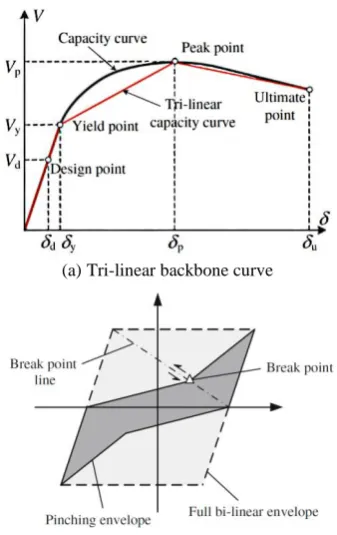
A trilinear backbone curve is used herein to simulate the inter-story nonlinear properties (Figure 3a) because it can accurately represent the inter-story behavior of a structure with acceptable modeling complexity and computational accuracy. In addition, a single-parameter hysteretic model proposed by Steelman and Hajjar [15] is adopted herein (Figure 3b), because it requires limited amount of detailed building information.
The nonlinear MDOF model requires only several general characteristics of a building (i.e., function of the
Figure 2. Concept of the nonlinear MDOF shear model
(a)Tri-linear backbone curve
(b)Single parameter hysteretic model
building, structural type, construction year, area, building height, and number of stories), which greatly simplifies the modeling effort of large number of regular buildings in a region. According to the above general characteristics [12], the MDOF models can be created for seismic damage simulation.
2. 2. 2. Parallel Computing Seismic simulation involving hundreds and thousands of buildings in a city is a computationally challenging problem. The graphics processing units (GPUs) are employed to perform a parallel computing of the simulation based on the MDOF model [16], which can accelerate the seismic damage simulation with thousands of buildings.
2. 2. 3. Obtain Collpsed Buildings The above simulation can output collapsed buildings [17]. In addition, the distribution of collapsed buildings can be visualized by in realistic 3D way [17].
2. 3. Analysis on Impact Ranges of Collapsed Buildings
2. 3. 1. Obtain the Heights of Collapsed Buildings For any collapsed building, the height (denoted as H) needs to be obtained.
2. 3. 2. Calculate the Probalitied of Impact Ranges Based on the investigations of the Great Hanshin earthquake, Nishino [6] proposed a probabilistic model of debris distributions caused by collapsed buildings, as shown in Figure 4.
The debris width w is described by the following triangular distribution, whose minimum a, maximum b, and mode c are defined as H/8, H/2, and H/4, respectively. Thus, the exceedance probability pl, which is the probability for whether the location with a
Figure 4. Impact range caused by collapsed buildings [6]
distance of l from the building boundary is covered by the debris, can be expressed as the following Equation (1):
2
2
( )
1 ( )
( )( )
1 ( )
( )
( )
( )( )
l r
l a
a l c b a c a
p P w l
b l
c l b b a b c
− −
− −
= − =
−
− −
(1)
According to Equation (1), the maximum and minimum impact ranges caused by the collapsed buildings are H/2 and H/8, respectively; while, the average range (i.e., pl = 50%) is 0.23H.
2. 2. 3. Determine the Impact Ranges Generally, the average impact range is recommended for analysis on road blockage. Nevertheless, the maximum impact range (i.e., w = H/2) is adopted in the case study of this work, to highlight the influence on the traversability of road network due to building collapse.
2. 4.Traversability Analysis of Road Network 2. 4. 1. Create the Models of Road and Buildings in GIS As a widely used GIS platform, ArcGIS is adopted in this study. The models of buildings and road network are created in ArcGIS, respectively.
Step 1: According to the satellite images of urban areas, draw the footprints of buildings using the polygon function in ArcGIS.
Step 2: Input the corresponding attribute information (e.g., structural types and heights) of the building footprints by using the function of attribute table in ArcGIS.
Step 3: Draw the road network according to the satellite images of urban areas, by using the line function in ArcGIS.
Step 4: Divide the road network into different segments by breaking crossed lines in ArcGIS.
Step 5: Input the corresponding attribute information (e.g., width and length) of the road segments by using the function of attribute table in ArcGIS.
2. 4. 2. Determine the Traversability Criterion With the assumptions that the width of the road is r and the distance from the building boundary to the road boundary is d, if the impact range w is smaller than d, the collapsed building has no influence on the road (i.e., normal state); if the impact range w is greater than d but not beyond the half width of the road (i.e., r/2), the traversability of the road is limited (i.e., limited state); if
,
, / 2
, / 2
Normal if w d
Limited if d w d r
Blocked if d r w
+
+
(2)
2. 4. 3. Create the Buffers of Impact Range The buffer areas of the impact ranges of collapsed buildings are created for the following overlay analysis, by using the buffer function of in ArcGIS.
2. 4. 4. Overlay Analysis on Traversability The buffer areas of impact ranges and the road widths are used to perform an overlay analysis (see Figure 5). Based on the overlay analysis and Equation (2), the traversability of the road network can be determined in ArcGIS.
2. 5.Determination of Optimal Rescue Path 2. 5. 1. Define Traversability Parameters The road network is made of many road segments and each segment has its attributions (e.g., distance and travel speed). For a normal road segment, its distance and travel speed is also normal; for a limited road segment, its distance does not change but travel speed is reduced to one third of the original value; for a blocked road segment, its distance is thought to be infinite and its speed is set to be zero.
2. 5. 2. Determine the Criterion of Optimal Rescue Path The minimum travel time is thought to a criterion for the optimal rescue path.
2. 5. 3. Analysis on Optimal Rescue Path According to the above definitions, the optimal rescue path can be determined by using the Network Analyst function in ArcGIS.
3. RESULTS AND DISCUSSIONS
3. 1.Introduction of Case Study A typical Chinese university campus is selected herein. The campus covers an area of 389.4 ha with more than 600
Figure 5. Overlay analysis between impact ranges and roads
buildings with different structural types. The models of buildings and road network are created in ArcGIS according to the proposed method in this study.
3. 2. Seismic Damage Simulation Assuming that the campus is hit by an earthquake, the ground motion of 1999 Chi-Chi earthquake is employed. Note that the peak ground acceleration (PGA) of the ground motion is aggregated to 800 gal to highlight the influence of the collapsed buildings caused by the earthquake.
By using the MDOF model, the high-fidelity seismic damage of all the buildings in this campus is simulated and the collapsed buildings are determined, as shown in Figure 6.
3. 3. Traversability of Road Network The impact range of the collapsed buildings can be determined according to the recommended debris distribution model by this study. Based on the proposed method in this work, the post-earthquake traversability of the road network in the entire campus can be analyzed, as presented in Figure 7.
Figure 6. The high-fidelity building seismic damage of the campus
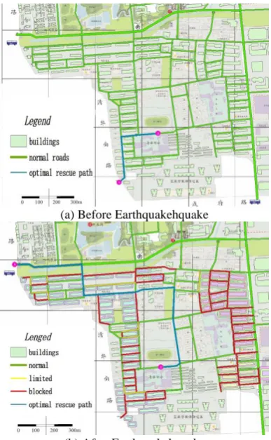
3. 4. Optimal Rescue Path To analyze the influence on the optimal rescue path due to the road traversability, a comparison of optimal rescue path before and after the earthquake is performed. As demonstrated in Figure 8, a playground is assumed as an emergency shelter and the west and southwest gates of the campus is the entrance for this shelter. Through the proposed method in this study, the optimal rescue paths from the gates to the shelter before and after the earthquake are calculated, respectively, as shown in Figure 8.
3. 5. Discussions The results indicates the post-earthquake traversability of road network can alter the optimal rescue path, which has a significant influence on the post-earthquake emergency responses. Before the earthquake, Figure 8a indicates that the optimal rescue path is from the southwest gate to the playground, because the southwest gate is much nearer than the west gate. However, after the earthquake, the optimal rescue path becomes from the west gate to the playground (see Figure 8b). This is because the roads from the near southwest gate to the playground are blocked by the collapsed buildings. If without the analysis result of this study, the normal path in Figure 8a would be generally
(a) Before Earthquakehquake
(b) After Earthquakehquake
Figure 8. The optimal rescue path before and after the earthquake.
selected. As a result, this path would be unreachable, leading to extensive delays for rescue. In contrast, with the assistance of the analysis result of this study, an optimal rescue path would be selected, which could avoid the influences of collapsed buildings.
Besides, the post-earthquake optimal rescue path gets longer due to the influence of collapsed buildings. As shown in Figure 8, the distances of the optimal rescue path before and after the earthquake are 398.7 m and 1404.1 m, respectively. This indicates that the post-earthquake optimal rescue path extends to 3.5 times than the normal path, due to the traversability considering building collapse. Consequently, the post-earthquake rescue will spend more time than usual situations. Therefore, this study provides important reference for the preparedness of post-earthquake recues.
On other hand, the post-earthquake traversability of road network also demonstrates the necessity of reinforcing the possible collapsed buildings. By comparing Figures 6 and 7, it can found that the collapsed buildings in southwest area of the campus are more than other areas, thus the traversability of road network is also worse. Therefore, the results of road traversability analysis agree with the distribution of seismic damage. When collapsed buildings get fewer, the post-earthquake traversability of road network will be better, which facilities the post-earthquake emergency responses.
4. CONCLUSIONS
An analysis method on the post-earthquake
traversability of road network considering building collapse is proposed based on a high-fidelity seismic damage simulation model (i.e., the MDOF model), and a case study of a typical Chinese university campus is performed in this study.
By using the proposed method, the seismic damage of buildings in an urban area can be simulated and thus influences on the traversability of road network due to building collapse can be analyzed. Based on the post-earthquake traversability, the optimal rescue paths can be determined. The results of case study indicate building collapse can alter the optimal rescue path, which has a significant influence on the post-earthquake emergency responses. Therefore, this study can provide a critical reference for the post-earthquake decision-making on emergency responses.
post-earthquake fires will be studied to consider the multi-hazard effect; on the other hand, the post-earthquake resilience of road network will be also investigated based on the traversability. The future studies have a potential to be one of the solutions to building resilient cities.
5. ACKNOWLEDGEMENT
The authors are grateful for the financial support received from National Key R&D Program of China (No. 2018YFC0809900), National Natural Science Foundation of China (Grant No. 51978049) and
Fundamental Research Funds for the Central
Universities (FRF-BD-18-007A).
6. REFERENCES
1. Parsaeifard, N. and Nateghi, A., "The effect of local damage on energy absorption of steel frame buildings during earthquake",
International Journal of Engineering, Transactions B:
Applications, Vol. 26, No. 2, (2013), 143-152.
2. Biswas, R., "Evaluating seismic effects on a water supply network and quantifying post-earthquake recovery",
International Journal of Engineering, Transactions B:
Applications, Vol. 32, No. 5, (2019), 654-660.
3. Bono, F. and Gutiérrez, E., "A network-based analysis of the impact of structural damage on urban accessibility following a disaster: The case of the seismically damaged port au prince and carrefour urban road networks", Journal of Transport
Geography, Vol. 19, No. 6, (2011), 1443-1455.
4. Sakakibara, H., Kajitani, Y. and Okada, N., "Road network robustness for avoiding functional isolation in disasters",
Journal of Transportation Engineering, Vol. 130, No. 5,
(2004), 560-567.
5. Argyroudis, S., Selva, J., Gehl, P. and Pitilakis, K., "Systemic seismic risk assessment of road networks considering interactions with the built environment", Computer‐Aided Civil
and Infrastructure Engineering, Vol. 30, No. 7, (2015),
524-540.
6. Nishino, T., Tanaka, T. and Hokugo, A., "An evaluation method for the urban post-earthquake fire risk considering multiple scenarios of fire spread and evacuation", Fire Safety Journal, Vol. 54, (2012), 167-180.
7. Najafgholipour, M. and Soodbakhsh, N., "Modified differential transform method for solving vibration equations of mdof systems", Civil Engineering Journal, Vol. 2, No. 4, (2016), 123-139.
8. Rastegarian, S. and Sharifi, A., "An investigation on the correlation of inter-story drift and performance objectives in conventional rc frames", Emerging Science Journal, Vol. 2, No. 3, (2018), 140-147.
9. Elhozayen, A., Laissy, M.Y. and Attia, W.A., "Investigation of high-velocity projectile penetrating concrete blocks reinforced by layers of high toughness and energy absorption materials",
Civil Engineering Journal, Vol. 5, No. 7, (2019), 1518-1532.
10. Forcellini, D., Tanganelli, M. and Viti, S., "Response site analyses of 3d homogeneous soil models", Emerging Science
Journal, Vol. 2, No. 5, (2018), 238-250.
11. Peng, M. and Cui, W.J., "Study on seismic dynamic response of shallow-buried subway station structure and ancillary facilities",
Civil Engineering Journal, Vol. 4, No. 12, (2018), 2853-2863.
12. Lu, X. and Guan, H., "Earthquake disaster simulation of civil infrastructures, Springer, (2017).
13. Lu, X., Han, B., Hori, M., Xiong, C. and Xu, Z., "A coarse-grained parallel approach for seismic damage simulations of urban areas based on refined models and gpu/cpu cooperative computing", Advances in Engineering Software, Vol. 70, (2014), 90-103.
14. Nateghi, F., Dehghani, A. and Tabnak, A., "Seismic damage and disaster management maps (a case study)", International
Journal of Engineering, Transactions B: Applications, Vol.
21, No. 4, (2011), 337-344.
15. Steelman, J.S. and Hajjar, J.F., "Influence of inelastic seismic response modeling on regional loss estimation", Engineering
Structures, Vol. 31, No. 12, (2009), 2976-2987.
16. Xu, Z., Lu, X. and Law, K.H., "A computational framework for regional seismic simulation of buildings with multiple fidelity models", Advances in Engineering Software, Vol. 99, (2016), 100-110.
An Analysis Method on Post-earthquake Traversability of Road Network
Considering Building Collapse
Z. Xu, W. Jin, M. Zheng
Beijing Key Laboratory of Urban Underground Space Engineering, School of Civil and Resource Engineering, University of Science and Technology Beijing, Beijing, China
P A P E R I N F O
Paper history:
Received 11 July 2019
Received in revised form 8 September 2019 Accepted 13 September 2019
Keywords:
Traversability Building Collapse Road Network Seismic Demage
Geographic Information System
هدیکچ
هدش ماجنا هلزلز رد نامتخاس یشاپورف زا یشان یا هداج هکبش ندوب هدنکارپ زا یریذپریثأت تیمک نییعت فده اب هعلاطم نیا یشاپورف هب هجوت اب هلزلز زا دعب هکبش زا روبع تیلباق دروم رد لیلحت و هیزجت شور کی ، روظنم نیا یارب .تسا تخاس م ا خیرات لیلحت و هیزجت ، لوا .تسا هدش هئارا ن
یدازآ زا یا هجرد دنچ لدم ساسا رب یا هزرل خساپ نامز
(MDOF)
نییعت ار هدش یشلاتم یاهنامتخاس ناوت یم هک یروط هب ، دوش یم ماجنا یا هقطنم نامتخاس یاه هورگ یارب
کی ساسا رب یشلاتم یاهنامتخاس هبرض هدودحم ، نآ زا سپ .درک م
د ، ماجنارس .دوش یم هبساحم یایاقب عیزوت یلامتحا ل
یاهریسم نییعت لح هار ، نیاربانب و هدش یحارط هبرض یاه هنماد ساسا رب اه هداج هکبش یگدنکارپ تیلباق زیلانآ متیروگلا ( ییایفارغج تاعلاطا متسیس رتسب زا هدافتسا اب زین هنیهب تاجن
GIS)
م کی هب هجوت اب .تسا هدش یحارط ط
ا یهاگشناد هعل
هدش لیلحت یزاجم یا هلزلز یویرانس کی رد نامتخاس یشاپورف لیلد هب هداج هکبش یرادیاپ تیلباق یور رب هک یتاریثأت ، یهجوت لباق ریثأت هک ، دهد یم رییغت ار هنیهب تاجن ریسم نامتخاس یشاپورف هک دهد یم ناشن یدروم هعلاطم جیاتن .تسا ا سپ یرارطضا یاهخساپ رد ز
هب هلزلز زا سپ هلزلز زا سپ هکبش شیامیپ زا یریذپریثأت دناوت یم هعلاطم نیا .دراد هلزلز
![Figure 4. Impact range caused by collapsed buildings [6]](https://thumb-us.123doks.com/thumbv2/123dok_us/15816.2001552/3.595.85.259.540.727/figure-impact-range-caused-collapsed-buildings.webp)