Available Online at www.ijpret.com
565
INTERNATIONAL JOURNAL OF PURE AND
APPLIED RESEARCH IN ENGINEERING AND
TECHNOLOGY
A PATH FOR HORIZING YOUR INNOVATIVE WORK
DESIGN & IMPLEMENTATION OF LOCATION AWARENESS & SHARING SYSTEM
USING GPS & GPRS
PRANALI BAID1, MADHURA KADLAG1, AKSHAY SHARMA1, MOHIT HIRE1,
AMOL POTGANTWAR2
1. B.E. Student, Department of Computer Engineering, SIEM, Nasik, India 2. Asst. Professor, Department of Computer Engineering, SIEM, Nasik, India
Accepted Date: 27/02/2014 ; Published Date: 01/05/2014
\
Abstract: Where am I? Where am I going? Where are you? What is the best way to get there? When will I get there? GPS technology can answer all these questions. GPS satellite can show you exact position on the earth any time, in any weather, no matter where you are! GPS technology has made an impact on navigation and positioning needs with the use of satellites and ground stations the ability to track aircrafts, cars, cell phones, boats and even individuals has become a reality. There are no subscription fees or setup charges to use GPS. So we are creating an innovative application introduced along with a mobile application to connect to various users and know their respective locations. It also allows users to set alert for some specific location. The user would then be notified with this alert, whenever he/she comes within that location proximity. It also provides special functionality of tracking the user’s location history with the help of Google maps. Users can also share their location with friends and family. Further, users can take advantages of emergency features which send user’s current location to emergency numbers.
Keywords: GPS, LBS, J2ME, Midmaps, Google maps, MySQl.
Corresponding Author: MS. PRANALI BAID
Access Online On:
www.ijpret.com
How to Cite This Article:
Pranali Baid, IJPRET, 2014; Volume 2 (9): 565-572
Available Online at www.ijpret.com
566 INTRODUCTION
The advancement in mobile technology coupled with the advancement in wireless technology that provides continuous Internet connectivity have open up new opportunities for businesses to leverage on, such as location-based services. Location-based services use the location of mobile device users to bring location-specific and personalized services and information to them. These services allow users to receive up-to-date information about their surroundings, save time and money, and make better, informed real-time choices. It also enables businesses to build and maintain customer relationships, increasing their profit gain potential. ThereIn cell phones, global positioning system (GPS) tracking and sharing are some of the advancements.GPS systems can be used when outdoors for activities such as hiking or camping.
Within the last few years, mobile phones spread like wild fire. With more than 2 billion phones around the globe and more mobile than fixed line subscribers, mobile phone industry is the most growing industry in the world. Location Based Services attracts more and more users to take advantages of these services. A location-based service basically answers three questions: Where am I? What's around me? And how do I get there? They determine the location of the user by using one of several technologies for determining position (such as GPS), and then use the location and other information to provide personalized applications and services.
I. Literature Survey
This section deals with some of the existing works related to the proposed mobile solution, mainly, using tracking systems through GPS or GSM cell. In paper [7], we will discuss the detailed design specifications of this system and in paper [8], we deal with the detailed implementation of this system.
In paper [22], the author proposes an application Locating Friends and Family Using Mobile Phones with Global Positioning System (GPS) based on client-server architecture that helps the users to locate their family members and receive alerts when their friends are nearby. The mobile application are implemented using J2ME where the most recent APIs and other older APIs are combined together in order to make the application reliable on all types of mobiles. The type of the Database used in the system was MySQL.
Available Online at www.ijpret.com
567 In paper [10], two techniques were described to locate and track cellular phones using digital cellular mobile telephony networks. The first technique is based on time of arrival (TOA) methods with a minimum of three base stations required, while the later uses angle of arrival (AOA) methods that require only two base-stations, though greater accuracy is possible with three. Both TOA and AOA methods were examined for a multipath fading environment.
As it may be seen in the above-mentioned systems, most of them provide dedicate solutions using tracking methods to monitor a mobile device. Our proposal is designed for a regular mobile phone that incorporates a GPS. Unlike the systems mentioned above, the main feature of our application provides the user the ability to locate him, send his own location via SMS and share his location with friends through a web server.
II.Proposed System architecture
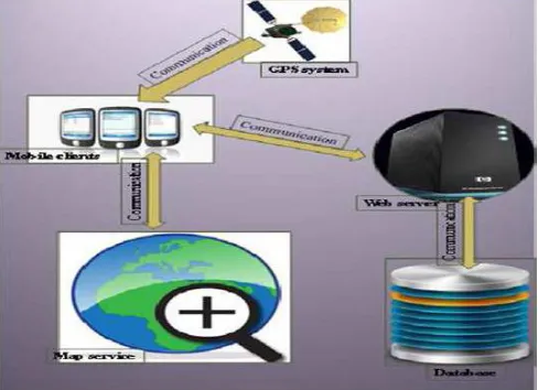
The application architecture and its working principle are centered on the use of GPS. It is the most common technology for these kinds of applications. The centralized database server provides a coordinate's database to the users so they can get the location of friends and relatives and dates their own location on the server. The purpose of choosing centralized data sharing is to reduce the storage overhead on each phone. Otherwise, instead of using centralized database each mobile may have its own database stored on the phone and share these databases between different users. The internet is the medium that is used to transfer the user data and service request from the mobile to the server and then the requested information back to the user. Figure 3.1 shows the main 5 elements that construct the system which are the GPS system, the mobile clients, web server and the database.
3.1 Mobile clients (Mobile):
The mobile requests its location from the global positioning system periodically and sends it through the communication network to the server. The user can request the location of a family member at any time from the server. Mobile client can also send its current location via SMS to any mobile number. Mobile client also has an internal database to store application settings. The mobile client application is named as GPS Locator.
3.2.2 Server
The server receives users' location and updates the user about the location of family members.
3.2.3 Database
Available Online at www.ijpret.com
568 sharing his location. Database tuple mainly has six attributes namely who, whom, latitude, longitude, altitude and time which stores user's mobile number, mobile number of other user with whom user is sharing his location, latitude coordinate of user location, longitude coordinate of user's location, altitude coordinate of user's location and time at which user updates his location. Whenever, user updates his location the time is also updated.
Fig 3.1 System Architecture
3.2.4 GPS
Available Online at www.ijpret.com
569 Fig 3.2: System Requirements
III.METHODOLOGY FOR DEVELOPMENT
The mobile application will be implemented using J2ME while GWT is used for implementing server functions and MYSQL is used for the database. The implementation is easily under-stood by dividing this task into several steps. First we will see the implementation of mobile clients, then the web server and database further we will see how we are integrating external map service with our application.
4.1 Mobile Client Side Implementation
Available Online at www.ijpret.com
570 Fig 4.1: JAVA ME Technology Specifications
4.2 Graphical User Interface (GUI)
MIDP applications are expected to run on many different mobile phones without modification. This is particularly difficult in the area of user interface; Mobile Information. Devices (MIDs) have got screens of all sizes, in grayscale and in color. Furthermore, for input, the MIDP is fairly open-ended. The input devices on MIDs vary widely in their abilities, from numeric keypads to alphabetic keyboards and soft keys to touch screens. The minimum screen size man dated by the MIDP is 96 x 54 pixels, with at least one bit of color depth. Below there are some important guidelines that we keep in mind while designing the application with MIDP graphical API functionality.
4.3. Get Location
The location includes the latitude, longitude and altitude coordinates. These coordinates can be calculated using the JSR-19[8] location API available in J2ME. JSR-19 specifications dense a Java 2 Micro Edition (J2ME) optional package to enable location-aware applications for Mobile Information Device Profile (MIDP) based devices. Provider can use the gathered location data to create Location objects and distribute them to JSR-19 Java applications.
4.4. Location Sharing
Available Online at www.ijpret.com
571 4.5. Web Server Side Implementation
In this feature there will background service running on mobile application that will send user data to the web services using HTTP protocol. Background service for sending location details of the user periodically to the web service and web service will store sent location details to the database. Mobile application will send data to the web service in JSON format. As data received at web service from the mobile application the received data will be persisted to the database server for future use.
The application needs centralized database for the purpose of location sharing. MYSQL is used for the database and GWT is used for implementing server functions to modify these data as user demands.
4.6. Map Services
This part mainly provides such functions as parallel moving, zoom, geocoding and relocate center; Location service: exchanging data between client and server, displaying map information that centered by mobile terminal in real time. The MidMaps[14] is the map service which provides Google maps for our application. The Google maps server contains a vast earth image database. This method is only used for research purposes. It is not a licensed method to access the Google maps database. Google maps is latitude and longitude related [12].
CONCLUSION
Here we are designing java application which provides the users current location and sharing location with friends and family and views them on maps. Users can also take benefit of this application in emergency situations by using emergency feature of this application. To get the location coordinates, application is using GPS (Global Positioning System) as location provider.
Thus in this project we are implementing the location tracking system to keep track the location details of the registered user, we also can set the location based alerts for reminders settings. In this, there is also a facility of creating various of peoples for locating them. We can track the location according to the date and the time. The whole location schedule of a registered member can be seen through this application.
REFERENCES
1. G.Lawton, "Moving Java into Mobile Phones", Computer, vol. 35, no. 6, (802) June, pp. 11-8.
2. J. McNamara, _GPS for Dummies_, For Dummies, 1st edition, (998).
Available Online at www.ijpret.com
572 4. http://hyperphysics.phy-astr.gsu.edu/hbase/gps.html, (812) July.
5. http://www.gps.gov/, (812) July.
6. Connected Limited Device Con_guration (CLDC), http://java.sun.com/products/cldc, (812) July.
7. Mobile Information Device Pro_le (MIDP),
http://java.sun.com/products/midp/whatsnew.html, (812) July.
8. Java Community Process: Location API for J2ME Speci_cation 1.0 Final Release, (803).
9. http://developers.sun.com/mobility/midp/articles/wma2/, (812) July.
10.http://www.ibm.com/developerworks/wireless/library/wi-extendj2me/, (812) July.
11.http://www.rysavy.com/Articles/GPRS/GPRS.htm, (812) July.
12.http://easyinfo.in/info/gprs.html, (812) July.
13.http://www.yale.edu/pclt/COMM/TCPIPHTM, (812) July.
14.http://www.protocols.com/pbook/tcpip1.htm, (812) July.