9
RECENT ORTHOPHOTOMAPS REQUIRED IN FOREST
MANAGEMENT WORK USING DRONES
FLORIN ACHIM1, FLORIN DORIAN COJOACĂ1, RĂZVAN RĂDUCU1,
GABRIEL CHIȚU1, CĂTĂLIN CRISTIAN1, IULIAN MOISĂ1,
CĂTĂLIN STANCIU1
1 - I.N.C.D.S. Marin Drăcea
keywords: drone, Unmanned Aerial Vehicle UAV, orthophotomaps, forest planning, GIS
ABSTRACT
The research carried out in the framework of the forest fund public property of the state, uses the advantages of drones in obtaining the data and information required for the forest area concerned in the construction of the forests in Romania.
Data and information obtained as a result of the flight with drones-UAV chosen in three locations under distinct geomorphological characteristics, contribute to the methodology of work with the instruments flight without pilot (drones) in the forestry field.
The products obtained by processing images acquired airlines with flight without pilot (drones): the cloud of points and 3Dmesh, the digital model of the surface (DSM) and orthophotomaps, can contribute to the completion of the landscape database supplied to the development of forestry management plan.
At the same time, the orthophotomap obtained from aerial image processing taken with unmanned aircraft (drones) contributes to the process of updating the cartographic basis required for forest planning.
Preliminary analysis of the orthofotomaps obtained, regarding the elements of interest for the forest vegetation can assist the activity of forestry structures and public authority in the field, in sustainable forest management by: ensure the integrity of the forest fund and permanence of the forest, ensure the adequacy of the legal continuity, institutional and operational in the forest management, the identification of the necessary work to prevent and control pests and diseases of the forest, the monitoring of the areas affected by destabilizing factors.
INTRODUCTION
The development of a forest management plan involves a thorough documentation and a detailed study of the field for the collection as accurate data and information about the. Part of the data and informations are obtained by exploiting the cartographic base concerned from the forestry management plan. The cartographic material used in the management planning of the forests contain: topographic plans, cadastral plans,
ortophotomaps, landscaping maps, aero-photograms, satellite images, etc (Seceleanu, I.,
2012).
The general rule, of the forests planning is that the cartographic material used to be the most recently and the largest scale. Maintaining the updating of existing information on the basis of the cartographic requires financial efforts as well as the specific devices.
The spectacular evolution in recent years of the use of unmanned aircraft in various fields has created the premises for its use in forestry.
10
of clouds, if necessary, spatial resolution very high of images/data that allows access to the details very fine, the rapidity with which the data acquired may provide results and, last but not least, the costs much lower of operation. In present there are already very many experiments and practical application on the use of the data in the remote sensing (active and passive safety) acquired with sensors installed on the UAV.
At the moment, from the point of view of sources of the orthographic airframe type are available data produced by the Agency of Payments and Work in Agriculture (APIA) and the direction of the Military Topographic, which have national coverage and update at intervals of 3 years.
MATERIALS AND METHODS
PURPOSE AND OBJECTIVES
The purpose of the research is to use the information obtained by means of unmanned aircraft (drones) in forest planning and more precisely in the periodic updating of the cartographical material.
The objectives of the scientific and technical knowledge covered by the research shall consist of:
- development of the methodology for processing and analysing the data obtained using the UAV for creating orthophotomaps necessary in management, emphasizing, monitoring vegetation and forest infrastructure;
- creation and integration the geospatial data obtaining by inventory of the land and
the information provided by the use of the appliances flight without pilot (drones).
PLACE OF RESEARCH
Research was carried out the following forestry centers/Experimental Bases: - Experimental Base of Sacele - for the mountain area;
- Experimental Base of Mihaiesti - for the hill area;
- Forest district of Calarasi - for the plain area and flood plains.
When establishing the area where the drones were tested, account was taken of the country's relief conditions and, implicitly, the land with forest vegetation.
As a result, one of the criteria for selecting the areas where the tests were made was geomorphologic and it was proposed that in each large geomorphological group (plain, hill, mountain) there should be a forest district / Experimental Base.
Also, it was intended that the selected forest areas should have elaborate development work using GIS technology to allow rapid analysis of stands in relation to spatial distribution, biometric features, vegetation state and exploitability.
RESEARCH METHODOLOGY
At the office, the following operations were performed using a unit for data
processing(graphic station):
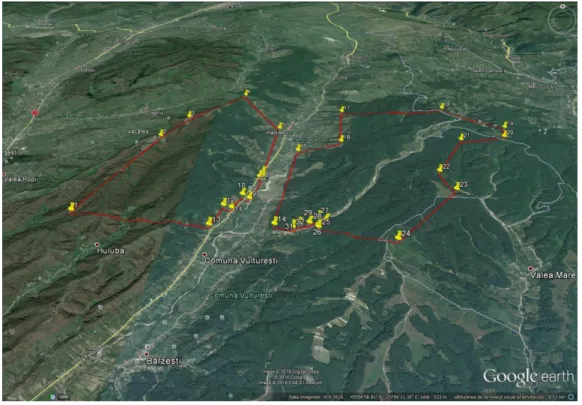
- export of the data related to the test area ( ua 35, 36, 37 from Ursoaia Valley), in a * .kml file, from the GIS database existing in the forestry arrangement of Experimental Base of Mihăeşti, into a new file (figure 1);
- import the new *.kml file, for the test area in Google Earth (https://earth.google.com/)
(fig. 2);
- verifying the location of that area on Google Earth, based on know elements identified on it (peaks, waters, roads, etc.) and validation of positioning;
- transferring data from test areas (*.kml files, georeferenced maps) from graphics station on an external storage device (USB stick, memory card, HDD, etc).
11
- Transfer the data on the test area (*.kml files, georeferenced maps) from the external storage to the laptop;
- using on the laptop the specialized software- eMOTION2;
- importing the *.kml file from the laptop into Software eMOTION2, with the test
area (forest management unit35, 36, 37 from forest Ursoaia Valley);
Figure 1 - Export the *.kml file from the GIS database from the test area
Figure 2 - Import the *.kml file in Google Earth with the test area
12
- input the data: the camera model mounted on the drones, the resolution (cm/pixel) set by the operator according to the objective pursued, the percentage of overlapping of images recorded by the camera;
- activation of the connection to the laptop with correction stations RTK
existing in the area ( accessed via mobile internet or L1, L2 external dual-GPS);
- selecting the take-off and landing corridor of the drones by checking the correspondence of the existing relief in the field with the viewed on the graphics in the eMOTION2 software (fig. 3);
Figure 3 – Selecting the take-off and landing corridor of the drones
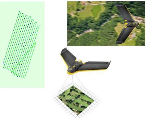
- the automatic generation of the flight plan with the paths, resulting the number of the missions and the time allocated to each mission (figure 4);
Figure 4 – Automatic generation of the plan with flight routes
13
- launching the drones for flight and taking a photo for test area, the drone begins its circular flight mission until it reaches the set height, than the RGB camera begins to photograph the test area on the linear route (figure 5);
Figure 5 – Photographing of the test area along the line according to the defined flight plan
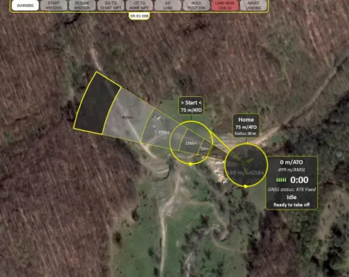
- the automatic landing procedure of the drone after taking the test area (figure 6):
Figure 6. – Automatic landing procedure
1 Approaching the set point for landing; 2 Descending to 75 meters;
14 5 Float at an angle and speed controlled; 6 Return to the horizontal flight at 20 meters; 7 The final brake at 3 m;
8 Direct landing;
- download the images captured by the RGB camera and files of type *.log from the internal memory of drone in laptop;
- resuming the flight until the test area is covered.
The data and information recorded in drone (*.log files) were downloaded in the graphics station for process them.
For the image processing has been used Pix4D Mapper Pro softwear, which is compatible with the operating system Windows 7,8,10 and ensure:
- processing image, generating and mosaic ortophotomaps 2D; - extracting coud of points (x,y,z);
- generating the 3D models-Digital Surface Model (DSM), Digital Terrain Model;
- the calculation of the volumes, the contour of the lines, export format; - orto-mozaic: geoTIFF (.tiff),KML tiles (.png/.kml) ;
- index map:geoTIFF (.tiff), .shp; -3D point cloud: .las, .laz, .ply, .ascii ;
- digital surface model (DSM): geoTIFF (.tiff) ; - 3D mesh - texture : wavefront (.obj) ;
- contour lines: .dxf, .shp ;
- google maps/ mapbox tiles: .KML tiles (png/.kml) ; - undirstorted images: .tiff.
Completing the steps from the Pix4D Mapper Pro, has passed to the processing the data in three steps:
- initial processing;
- the cloud of points and 3Dmesh;
- Digital Surface Model (DSM) and ortophotomaps.
15
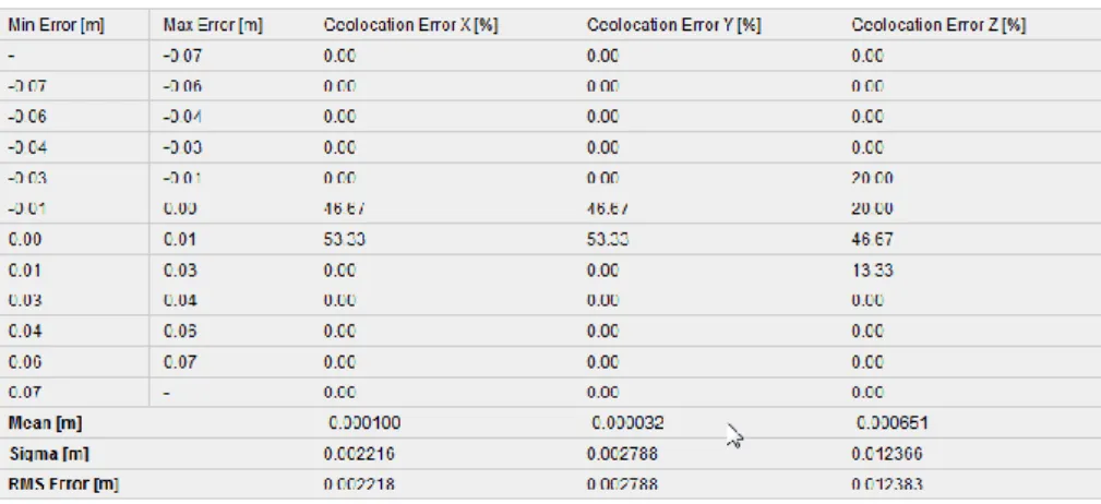
Figure 7. - Image calibration errors, overlay and georeference details
Finally, were obtained the following products: the cloud of points and 3Dmesh, digital surface model (DSM) and orthophotomaps.
RESULTS AND DISCUSSIONS
A first product obtained by aerial images with the drone is the orthophotomap. For the current stage of the research, we are interest of the following data and partial results which contain information provided by the orthophotomaps obtained through processes described above (Achim, F., s.a., 2016).
Thus, the analysis of the orthophotomaps obtained in the Experimental Base Sacele (figure 8), it can be seen that the crowns of the trees are diffuse and they cannot be delimited in many areas. Even if the pixel size is 15 centimeters, the area begin obtained from union several images, tree crows appear diffused and the information obtained is not conclusive.
16
Figure 8 - Detail on the orthophotomap EB of Săcele, with the inconclusive images of the tree crows
On the orthophotomaps resulting in Experimental Base of Mihăeşti the analysis (Gancz, V., 2005) was carried out as a result of overlaying on it the cartographic data from the GIS related to the arrangement in force (figure 9).
Compartment 34E was taken in the analysis, seeing a difference between the existing limits from cartographic base (topographic plan) and the image offered by orthophotomaps resulted from the aerial images processing taken over by the drones.
Figure 9 - Detail on the orthophotomap EB of Mihăești, with limits for 34E from GIS database (black line) and the vectorization lines from the ortophotomap
17
By vectorization the compartment 34E limits on the ortophotomaps, and analytically determining the surface, results the size of 0.54 hectares. The surface of compartment 34E taken from the dataset (also determined by the analytical method) is 1,08 hectares. Specify that on the orthophotomaps this ua 34E is easily observable, its composition (10ANN) being different from that surrounding trees.
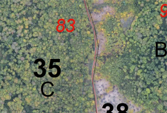
Also, in Experimental Base of Mihaiesti was analyzed the path of the road FE017=D83=1,9 km that crosses the territory covered by the orthophotomaps.
From the analysis made on the dates of the existing database and the orthophotomaps it can be noticed that there are some difference on the two sets of data/information between 0,5-17m on the route of the forest road (figure 10).
Figure 10 - Detail on the orthophotomap EB of Mihăești, with the path of the forestry road FE018 from GIS database (black line with red points) and the
vectorization lines from the orthophotomap(red line).
In Forest District of Calarasi, was studied compartment 44B from Management Unit II Chiciu, to determined the numbers of trees in this area.
On the new orthophotomaps we tried to identify the position of each tree and mark it manually with a red circle (figure 11). At the same time, we made on the field complete inventories with a number of 872 trees, of which 816 Populus euroamericana trees and 56 trees belonging to the category "hard wood".
18
a) b)
Figure 11 - Detail on the orthophotomap (a) and the existing trees (b) in compartment 44B- Management Unit II Chiciu (F.D. Călărași)
mark the identify trees
CONCLUSIONS
The preliminary analysis of the data and information provided by ortophotomaps achieved by processing images obtained with the aircraft without pilot presents the following points:
- verifying the correctness of the way of establishing the existing subcompartment in the forest arrangement;
- use the ortophotomaps in the phase of collecting data from the field to facilitate the orientation of the engineer in the field and in the delimitation of the subcompartments;
- the location with greater accuracy on the topographic map (primary material used in the construction of the forests) of the forest roads in particular and the roads in general, as well as other categories of land affected management of forests (yards, construction and deposits, compartment lines, land for animal food, land for the needs of the forestry administration, etc.);
- verification on the land of any area that can be newsubcompartments;
- estimation of the land cover index based on the information provided by the orthophotomaps and the possibilities of its determination on orthophotomaps;
- determining the number of trees in the compartments depending on the possibilities of identifying the tree crowns on the orthophotomaps.
19
At the same time, the products obtained from aerial image taking with UAV, contribute to the process of updating the cartographic basis necessary for the development of forests.
Also, the orthophotomaps carried out on the basis of the airline images help to raise the degree of accuracy in determining the parameters of the forest vegetation and consequently to raise the precision of the determination of the data contained in the forestry arrangements.
The products obtained by aerial image from the drones, the cloud of the points, 3Dmesh, digital surface model (DSM) and the orthophotomap, can complete the landscaping database, provide in the development of forest arrangements.
Preliminary tests on the new orthophotomaps on elements of interest for the forest vegetation can support the activity of the forest structures and the forestry authority in the sustainable management of forests by: ensure the integrity of the forestry fund and the permanence of the forest, ensure the adequate level of legal continuity , institutional and operational in the management of forests, identification of necessary works for the prevention and control of forest diseases and pests, monitoring of areas affected by destabilizing factors, etc.
The tests that can be carried out on the products obtained from aerial images acquired with drones may be extended to the other elements of interest for the forestry so, clear conclusions can be drawn about the necessity and usefulness of obtaining orthophotomaps, as the first products of using UAV in forestry.
It's also necessary to continue the study of testing other types of drones that can also cover the areas where this type of drone could not fly, as well as using other types of sensors for recording the images.
BIBLIOGRAPHY
1. Gancz, V., 2005 - Utilizarea analizei GIS în silvicultură. Studiu de caz- Revista pădurilor nr. 3/2005, Bucuresti;
2. Seceleanu, I., 2012 - Amenajarea pădurilor. Organizare si conducere structurală. Editura Ceres 505 p., Bucuresti;
3. Achim, F., s.a., 2016 - Utilizarea dronelor pentru înregistrarea informațiilor
dendrometrice ale arborilor și arboretelor în lucrările de amenajarea pădurilor, Referate stiintifice partiale, INCDS ,,Marin Drăcea”;