International Journal of Emerging Technology and Advanced Engineering
Website: www.ijetae.com (ISSN 2250-2459, ISO 9001:2008 Certified Journal, Volume 9, Issue 10, October 2019)
271
Stability Assessment for Preservation of Fallen Stone Cultural
Properties (I)
Min-Ho Jeong
1, Bo-Hyun Lee
2, Jong-Hyeon Jung
3, Byung-Hyun Shon
4 1,2Gyeongju National Research Institute of Cultural Heritage, South Korea3Faculty of Health, Daegu Haany University, South Korea
4Department of Environmental Engineering, Hanseo University, Seosan-si, South Korea
Abstract-- Sized about 6.8 m high, 4 m wide, 2 m thick, and weighing about 80 tons, the rock-carved stone Buddha statue of the Yeolam Valley of Mt. Namsan, Gyeongju was fallen and facing the ground on the slope of the mountain at the time of its discovery. A stability assessment was conducted on this rock-carved stone Buddha statue in the current state in which the carved nose of the fallen statue faces the rock base with a 5 cm gap. For an analysis of stability, the ground integers were drawn from the lab test results of the rocks, the thickness of the ground surface was assumed to be 1.5 m, which is the physical property value obtained from the seismic exploration, and the distance from the statue to the stone wall was estimated to be 5 m. The current level of underground water was estimated to be 1 m under the surface of the ground based on the results of a GPR survey and a seismic exploration. For the analysis of stability, the stability at the current level of underground water was first examined, and FLAC 2D was employed to for the analysis on the assumption that the level of underground water comes up the bottom of the stone Buddha statue. It showed that, if the level of underground water rises to the ground surface due to rainfalls, the bearing power will be reduced, weathering and eroding of the surfaces of the statue will be fast progressing, and the frictional force of the supporting points upon the rocks will be decreased, and this calls for the preventive measures including relocation of the statue.
Keywords –Stone Buddha statue, seismic velocity, finite difference method, stability assessment.
I. INTRODUCTION
The research area, the 1,000-year old city of Silla, has historically important tangible cultural assets such as Bulguksa Temple, Seokguram, Cheomseongdae, and Namsan valley. With a number of stone cultural properties, Gyeongju has been a historical, cultural, and tourist city of South Korea for a long time. Especially, various stone cultural properties are distributed including the Tomb of King Wonseong and Goe-reung, and East and West Three-story Stone Pagodas at Wonwonsa Temple Site. As they are exposed outdoors, it is inevitable to be weathered or damaged by external environment [1, 2, 3, 4, and 5].
On May 22, 2007, a rock-carved stone Buddha statue was discovered in the Yeolam Valley of Mt. Namsan, Gyeongju, Gyeongsangbuk-do Province (Fig. 1). The discovery was made by an expedition team that was dispatched to repair the seated Buddha statue in the valley and to check any other stone members that might have been lost. The place of discovery is on a mid-slope of the mountain located south of Gyeongju city, where large core stones detached from the outcrop of the slop are scattered about, and, at the time of discovery, the statue was lying with the Buddha's head on the carved surface facing downward on a slope of about 35 degrees. The rock is about 6.8 m high, 4 m wide, and 2 m thick. The nose of the statue was facing downward with a gap of mere 5 cm from the rock surface, and the statue, carved roughly 0.54 m in relief, was about 5.1 m high and 1.8 m wide, and its weight was estimated to be about 80 tons [6].
[Fig. 1] Statue when discovered
International Journal of Emerging Technology and Advanced Engineering
Website: www.ijetae.com (ISSN 2250-2459, ISO 9001:2008 Certified Journal, Volume 9, Issue 10, October 2019)
272
[Fig. 2] Upper/lower body-supporting structure[Fig. 3] Gap between nose and rock base
Being a historical relic of significant archaeological and cultural importance, the statue requires thorough pre-examinations into a number of problems that may occur in relocating it. Cracks may occur on the surface of the statue depending on the method to be employed, and in the worst scenario, it could be divided into two or more pieces due to bending stress, tensile stress, etc. Also, the ground surface could subside or be damaged due to local concentration of the stress on the statue. In consideration of this unstable state of the carved stone Buddha statue, an FLCA 2D method that uses the finite difference method to conduct a numerical analysis for the assessment of the stability of the statue [6].
II. SLOPE INTERPRETATIONS
A.Geological composition of Gyeongju Namsan
In the study area, basement rocks consists of Cretaceous sedimentary rocks, volcanic rocks, plutonic rocks between the late Cretaceous Period and the early Tertiary Period, and volcanic rocks and sedimentary tocks from the Tertiary Period [7, 8]. Cretaceous sedimentary rocks are comparable to the Daegu faults of the Hayang group [9], Jindong faults [10], or Ulsan faults [9, 10], and mostly consists of sandstone and shale. The area where the carved stone Buddha statue is located has mountains and hills of Cretaceous Bulguksa granitic rocks and the Daegu strata of the Gyeongsang Basin, making a relatively low topography. The water systems in the area are mostly of those of NS and NNE directions generated by faults and terraces [6]..
B.Topographical features of the surroundings of the statue
By using the numerical topographic maps provided by Korea's National Geographic Information Institute and the numerical elevation dataset provided by the U.S. Geological Survey based on the water systems of the study area, the individual elements constructing the topography of the mountains around the study area were analyzed to assess the disaster risk levels (Fig. 4 and Fig. 5) [6, 13, and 14].
[Fig. 4] 3D satellite image [Fig. 5] 3D topographic map
International Journal of Emerging Technology and Advanced Engineering
Website: www.ijetae.com (ISSN 2250-2459, ISO 9001:2008 Certified Journal, Volume 9, Issue 10, October 2019)
273
[Fig. 6] Gradient map [Fig. 7] Airth map.
[Fig. 8] Contributive areas [Fig. 9] Wetness indexes
[Fig. 10] Tangent gradient curvature [Fig. 11] Contour gradient curvature
III. FLAC2D-BASED STABILITY ASSESSMENT AT
CURRENT LOCATION
FLAC is an analytical program that allows both the linear and non-linear behavior analyses of the continuous objects, and it also allows simulation of the sides on which sliding or separation can take place by using the interface elements. The program also allows construction of the models of underground water and plane strain, plane stress, and axial symmetrical geometry. As the program supports the FISH function, a more realistic simulation is possible with the program (Fig. 12) [6, 13, and 14].
[Fig. 12] Vertical displacement of the ground (a) original ground (b) post-improvement (c) improvement (x 1.2)
FLAC 2D, the most commonly employed 2D program that uses the finite difference method (FDM), was used to conduct an analysis on the stability of the support points in order to assess the stress concentration on the base ground of the statue and the stability against subsidence. In addition, the Mohr-Coulomb model that is generally used to assess the dynamics of the ground was employed to examine the distribution of displacement, level of displacement occurred, etc. in order to analyze the stability of the ground. An analysis of the cross-section of the statue and four side lines from seismic profiling showed that the underground water level around the location of the statue might be distributed between GL-2 m and 5 m [6, 13, and 14].
Fig. 13, which is the result of a 3D analysis based on the seismic velocity data for the three side lines, shows that the area where the head of statue is located consists of deep filled-up soil and earth layers along with deep base rock lines, and the base rock lines get closer to the ground surface as it goes closer to the location where the feet of the statue exist. Using these FLAC features, an assessment of the statue's stability at the current location and based on its estimated weight of 70 tons was conducted, and the breaking and subsidence of the ground in relation to the concentration of stress under the local concentration of stress on the statue was predicted [6, 13, and 14].
[Fig. 13] 3D drawing of analysis on the elastic waves around the rock-carved triad Buddha located at Yeolam-gok, Namsan, Gyeongju City
C.FLAC 2D modeling
International Journal of Emerging Technology and Advanced Engineering
Website: www.ijetae.com (ISSN 2250-2459, ISO 9001:2008 Certified Journal, Volume 9, Issue 10, October 2019)
274
(a) (b)
(c)
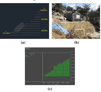
[Fig. 14] Cross section drawing (a), stone wall (b) and slide modeling (c) on the rock-carved triad Buddha located at Yeolam-gok, Namsan,
Gyeongju City referred to modeling
D.Ground constants used in FLAC 2D analysis
[image:4.612.64.275.129.322.2] [image:4.612.331.559.390.555.2]The ground integers used in analysis were subjected to FLAC 2D modeling toward the values of physical properties as shown in Table 1 using the lab test results. The thickness of the ground surface was assumed to be 1.5 m, which is the physical property value obtained from the seismic exploration, and the distance from the statue to the stone wall was estimated to be 5m. The current level of underground water was estimated to be 1 m under the surface of the ground based on the results of a GPR survey and a seismic exploration, and, to analyze stability, the stability at the current level of underground water was first examined, and then analyzed based on the assumption that the level of underground water comes up the bottom of the stone Buddha statue [6, 14].
Table 1.
Ground base contents used for FLAC 2D analysis
Classification Unit volume weight(t/m3) Cohesion (MPa) Internal friction angle(°)
Modulus of elasticity
(GPa)
Poission ratio
Sand(Sedentary
deposit) 1.79 0.05 32.0 0.02 0.35
Original ground
base, stone wall 2.50 5 40.0 20 0.25
Rock-carved
triad Buddha 2.50 13 57.3 48.0 0.387
E.Analysis result when the underground water level is 1 m under the statue base
As shown in Fig. 15, when the level of underground water is 1 m under the base of the statue, the maximum displacement of 0.7 mm occurred where the filled-up part meets the stone wall, and around the statue the maximum displacement of 0.002 mm occurred. In the filled-up area where the maximum displacement occurred, plastic deformation occurred due to tensile stress as shown in Fig. 16 (a, b) [6, 14, and 15].
[Fig. 15] Ground base boundary at the modeling of FLAC 2D
(a) (b)
(c) (d)
[Fig. 16] Result of reviewing the underground water level at lower 1m of the rock-carved triad Buddha -Displacement by the entire slide (a),
displacement near to the Buddha (b), the initial pore pressure condition on the model of numerical analysis (c), the pore pressure
condition after analysis (d)
F.Analysis result when the underground water level is the same as the statue base
International Journal of Emerging Technology and Advanced Engineering
Website: www.ijetae.com (ISSN 2250-2459, ISO 9001:2008 Certified Journal, Volume 9, Issue 10, October 2019)
275
(a) (b)
[image:5.612.61.279.132.299.2]
(c) (d)
Fig. 17. Result of reviewing the underground water level is at the bottom of the rock-carved triad Buddha -Displacement by the entire
slide (a), displacement near to the Buddha (b), the initial pore pressure condition on the model of numerical analysis(c), the pore
pressure condition after analysis (d).
[Fig. 18] Only the elastic range exists when the underground water level is at the bottom of the rock-carved triad Buddha
IV. CONCLUSIONS
The topographical features of the areas around the carved stone Buddha statue of the Yeolam Valley of Mt. Namsan, Gyeongju are one of the important elements in the assessment of the possibility of future landslides or collapses of the slopes. To assess the topographical features of the study area and the current state of its water system, the numerical topographic maps were used to produce the gradients map, vector map, airth map, contributive areas, wetness indexes, tangent gradient curvatures and contour gradient curvatures. The result of a disaster risk analysis on the surrounding areas showed that the areas have flowing waters converged and are relatively vulnerable to collapse. Therefore, erecting the fallen statue requires methods that take into consideration the overall topographical features of the areas and, after having erected it, preventive measures against landslides in the surrounding areas should be comprehensively examined [6, 14, and 15].
A subsidence stability analysis on the ground base of the carved stone Buddha statue conducted using FLAC 2D showed that the influence by underground water may not be significant on the assumption that most of the slopes consisted of the natural ground and boulders. This is likely because most displacements occur in the filled-up parts and displacements are being contained due to the stone wall. However, if the level of underground water rises up to the ground surface due to heavy rainfall, the bearing power of the soil layers will be reduced, the surfaces of the Buddha statue will be fast weathered and eroded, and the soil on the ground surface will be eroded to eventually reduce the frictional force of the supporting points due to streamlet erosion. This analysis result calls for the establishment of preventive measures including moving the statue against the events of future heavy rain falls [6, 14, and 15].
Acknowledgment
This research was supported by Basic Science Research Program through the National Research Foundation of Korea (NRF) funded by the Ministry of Education (No. 2016-R1D1A1B03 -936168).
REFERENCES
[1] Jong-Hyeon Jung, 2008. Effects of air pollutants on the health/environmental risk assessment and weathering of stone cultural properties in Gyeongju and its vicinities. Daegu Haany University, Ph. D Dissertation.
[2] Jong-Hyeon Jung, Min-Ho Jung, Won-Joon Choi, Jung-Ho Seo, In-Jo Hwang, and Byung-Hyun Shon, 2010. Effects of air pollutants on the weathering of stone cultural properties in Gyeongju. Journal of the Korea Academia-Industrial cooperation Society, 11(2), 597-603. [3] Jong-Hyeon Jung, Min-Ho Jung, and Byung-Hyun Shon, 2007.
Weathering and Damage Characteristics of Stone Cultural Property in Gyeongju. Silla culture, 30, 243-272.
[4] Jong-Hyeon Jung, Min-Ho Jung, Byung-Hyun Shon, Kun-Jik Lee, Jung-Ho Seo, and Hyun Gyu Kim, 2008. Weathering and Damage Characteristics of Bulguksa Stone Cultural Properties-Tabotop and Bulguksa Three-story Stone Pagoda. Silla culture, 31, 107-135. [5] Byung-Hyun Shon, Jong-Hyeon Jung, Hyun Gyu Kim, Jeong-Gun
Yoo, and Hyung-Kun Lee, 2005. Effects of Salts and Acid Solutions on the Weathering of Granites. J. of KSEE, 27(1), 101-108. [6] Min-Ho Jeong, Bo-Hyun Lee, Jong-Hyeon Jung, and Jeong-ho Seo,
2017 International Symposium on Conservation of Cultural Heritage in East Asia, pp.139-143
[7] Ministry of Land, Infrastructure and Transport, 2009, Guide to Structural Foundation Design Standards, Korea Geotechnical Society, pp. 677-678.
International Journal of Emerging Technology and Advanced Engineering
Website: www.ijetae.com (ISSN 2250-2459, ISO 9001:2008 Certified Journal, Volume 9, Issue 10, October 2019)
276
[9] Yon-joon Park, Young-soo Chae, Gwang-ho, and Young-sik Baik,1999, Slope Stability Analysis by Slice Method and Finite Difference Method - A Comparative Study-, Collection of dissertations of Korea Geotechnical Society, 15(6), 263-272. [10] Kwang-min Jin, Min-jung Lee, and Young-seog Kim, 2009,
Geological study on the collapse of a carved stone Buddha statue in Yeolam valley of Namsan, Gyeongju, Korea, Journal of the Geological Society of Korea, 45(3), 235-247.
[11] Hong-seok Yang, 2013, A Study on Shear Behavior of Soil-Rock Interface and Slope Stability Analysis, Doctoral Dissertation of the University of Seoul, pp. 59-90.
[12] Itasca Consulting Group, 2005, 5.0th ed. FLAC 2D, Minneapolis: Itasca Consulting Group.
[13] ITASCA, 2005, Theory and Background, Itasca Consulting Group, Inc.
[14] ITASCA, 2005, FLAC/Slope User's Guide, Itasca Consulting Group, Inc.