Geosciences Theses Department of Geosciences
12-18-2017
Zeolite Facies and Environmental Change in the
Plio-Pleistocene Baringo Basin, Kenya Rift
Karim Minkara
Follow this and additional works at:https://scholarworks.gsu.edu/geosciences_theses
This Thesis is brought to you for free and open access by the Department of Geosciences at ScholarWorks @ Georgia State University. It has been accepted for inclusion in Geosciences Theses by an authorized administrator of ScholarWorks @ Georgia State University. For more information, please [email protected].
Recommended Citation
Minkara, Karim, "Zeolite Facies and Environmental Change in the Plio-Pleistocene Baringo Basin, Kenya Rift." Thesis, Georgia State University, 2017.
BARINGO BASIN, KENYA RIFT
by
KARIM MINKARA
Under the Direction of Daniel Deocampo, PhD, PG
ABSTRACT
Sediments exposed in the Tugen Hills in the Central Rift of Kenya include an important
hominin-bearing succession of volcaniclastic and fluvio-lacustrine deposits. The Hominin Sites
and Paleolakes Drilling Project (HSPDP) retrieved a ~230 m core through a portion of the
Chemeron Formation, containing a highly resolved succession of strata spanning events leading
to the Plio-Pleistocene boundary (3.4-2.6 Ma). Trends in the character and abundance of zeolites
indicate changes in paleoenvironmental conditions with varying stability identified through
distinct facies assemblages. These seem to reflect high amplitude changes accompanying peak
earth-orbital eccentricity at ~2.7 Ma, and relative stability at low eccentricity at ~2.9-2.7 Ma.
This study suggests a decrease in K/Ca and an increase in Na/Ca with major fluctuations.
Zeolites act as terrestrial climate proxies in the absence of biogenic material, aside from intervals
of diatom-rich strata, and are suggesting episodes of strongest environmental fluctuations
~2.7-2.6 Ma and environmental stability ~2.9-2.7 Ma.
INDEX WORDS: Paleoclimate, Plio-Pliestocene, Zeolite, Equatorial East Africa, Lake Baringo,
BARINGO BASIN, KENYA RIFT
by
KARIM MINKARA
A Thesis Submitted in Partial Fulfillment of the Requirements for the Degree of
Master of Science
in the College of Arts and Sciences
Georgia State University
Copyright by Karim Minkara
BARINGO BASIN, KENYA RIFT
by
KARIM MINKARA
Committee Chair: Daniel Deocampo
Committee: W. Crawford Elliott
Lawrence Kiage
Electronic Version Approved:
Office of Graduate Studies
College of Arts and Sciences
Georgia State University
DEDICATION
This thesis is dedicated to my father, for providing me an incredible example as a
scientist and as an intellectual human being for teaching me to never stop learning. His approach
at life and knowledge is why I chose the path I am on and to obtain higher education for the
ACKNOWLEDGEMENTS
I would like to acknowledge the immense dedication and collaborative efforts that the
HSPDP Tugen Hills team has contributed to the project prior to and after this thesis. Thank you
to the drilling and core description team, as well as the LacCore staff for making these analyses
possible.
I would not have completed this major accomplishment without the crucial guidance,
patience, and understanding of my advisor Dr. Daniel Deocampo, who although might be the
busiest man I have ever met, still made the time to point me in the direction of success.
Majority of preliminary XRD data, analysis, and troubleshooting, as well as critical
academic and life guidance credited to Nate Rabideaux, who was to me as much of a peer as he
was a mentor.
The SEM and EDS analysis would not be possible without Dr. Robert Simmons with the
BioImaging Core Facility at Georgia State University.
The assistance with preparation and analysis of the nearly 1,300 core samples are credited
to the undergraduate support from Cole Hairston, Morgan Garner, David Davis, Sanam
Chaudhary, and Thanh Vo. Thank you all for making the process a little less overwhelming.
I would also like to acknowledge Dr. Brian Meyer, who has played an important role in
my academic and professional development for my time as President of the AIPG club as well as
being a student in many of his courses.
I would also like to thank my fellow colleagues that I’ve earned the pleasure of meeting
during my time here at GSU as an undergraduate and graduate student. I’ve grown to enjoy the
community that the Department of Geosciences has fostered and will continue to look forward to
Research for this project is supported by the following grants earned by HSPDP: NSF
TABLE OF CONTENTS
ACKNOWLEDGEMENTS ... V
LIST OF TABLES ... IX
LIST OF ABBREVIATIONS ... XIII
1 INTRODUCTION ... 1
1.1 The Hominin Sites and Paleolakes Drilling Project ... 1
1.2 Lake Baringo Basin – Tugen Hills ... 3
1.3 Zeolite Diagenesis ... 7
1.4 Plio-Pleistocene East African Paleoclimate ... 8
1.5 Hypothesis Testing ... 10
2 MATERIALS AND METHODS ... 10
2.1 Site selection, coring, and initial core descriptions ... 10
2.2 Mineralogy ... 12
3 RESULTS ... 13
3.1 Stratigraphic Variation... 13
3.2 Zeolite facies... 16
3.2.1 Phillipsite facies ... 17
3.2.2 Clinoptilolite-heulandite facies... 20
3.2.3 Chabazite facies... 21
3.2.5 Diatomite facies ... 25
4 DISCUSSION ... 26
4.1 Geochemical evolution of the Lake Baringo Basin & Paleohydrology ... 26
4.1.1 Zeolite geochemistry ... 26
4.1.2 Paleohydrology ... 31
4.2 Implications for paleoclimate ... 32
5 CONCLUSIONS ... 36
REFERENCES ... 37
LIST OF TABLES
Table 1 Significant fossil localities of the Tugen Hills (collected from Hill, 2002). ... 2
Table 2 Schematic chemical formulae of primary zeolites. DEC = Dominant Extra framework
Cation (modified from Passaglia & Shepphard, 2001) ... 8
Table 3 40Ar/39Ar tuff dates reported by Denio et al., 2006, with depth in the BTB core material
using Table Interpolation age model, courtesy of Alan Deino. ... 35
LIST OF FIGURES
Figure 1 Lake formation through volcanism (Yuretich, 1982) ... 4
Figure 2 (A) Overview and (B) geologic map of Chemeron Formation, Tugen Hills with BTB
drill site labeled (modified from Deino et al., 2006). Cross sections and fossil localities
refer to Deino et al., 2006. ... 5
Figure 3 Composite stratigraphy of the Tugen Hills succession (modified from Kingston et al.,
2007) ... 6
Figure 4 (A) Core color, (B) lithology, and (C) magnetic susceptibility (MS) log data (25-point
running mean smooth) from LacCore Geotek XYZ point sensor data (modified from
Cohen et al., 2016) compared to (D) major zeolite and diatom-rich facies plotted to depth
(mbs) ... 15
Figure 5 Key to lithological symbols (Cohen et al., 2016) ... 16
Figure 6 Analysis of philipsite-bearing sample BTB-1A-65Q-2_1-3 (187.73 mbs): (A)
diffractogram showing peaks labeled with respective d-spacings, (B) core image
described as “orange-brown mottled bioturbated silty clays, some relict bedding, almost
completely overprinted pedogenic processes with scattered carbonate nodules, near
shore facies depositional environment” (C) SEM image depicting rectangular phillipsite
crystals within a clay matrix, (D) EDS spectrum of phillipsite showing the chemical
composition with cations K and Na, major elements of silicate framework Si, O, and Al,
trace amounts of Fe, Hf, and C identified in reading attributable to the instrument error
and carbon coating process for sample preparation. ... 18
Figure 7 Analysis for heulandite-bearing sample BTB-1A-31Q-2_23.5-25.5 (87.48 mbs): (A)
described as “medium brown, medium grain sands, disconformably overlies finegrained
lacustrine unit below due to loss of intermediate bedding by channeling and cross cutting
represented by this sandy unit, (C) SEM image depicting tabular heulandite crystal
fragments in a clay matrix, (D) EDS of heulandite with Ca and Na DEC with trace K and
Fe (top) and Al-rich clay with trace Na, Mg, Fe, K, and Ca (bottom). ... 21
Figure 8 Analysis for chabazite-bearing sample BTB-1A-23Q-1_33.5-35.5 (64.83 mbs): (A)
diffractogram showing peaks labeled with respective d-spacings, (B) core image
described as “greenish-grey silts and fine sands, generally not well bedded, excellent
evidence of soft sediment deformation (possibly earthquake liquefaction events), few
scattered laminae of coarse material, some calcite nodules, vivid green appears to mean
weathered volcanic glass (C) SEM image showing cubic chabazite crystals among clay
and possibly weathered wairakite, (D) EDS analysis describing the chemistry of
chabazite containing Ca and Na with trace Mg. ... 22
Figure 9 Analysis for analcime-bearing sample BTB-1A-28Q-1_141.5-143.5 (81.18 mbs): (A)
diffractogram showing peaks labeled with respective d-spacings, (B) core image
described as “dark black-grey course sand matrix, poorly sorted, small clasts, huge lithic
fragments emplaced in matrix, some carbonate nodules indicative of poorly developed
paleosols, bedding with some bands of coarse grained material and some beds of grey
and brown finer grained materials, bioturbation and mixed up bedding depositional
environment, lithic zones most likely subaerial (C) SEM imagery depicting euhedral
analcime crystals with clays, (D) EDS of analcime (top) occurring with clays consisting
Figure 10 (A) Core and (B) SEM images from diatomite bearing sample BTB-45Q-1_33.5-35.5
(128.81 mbs). ... 26
Figure 11 Thermodynamic stabilites for zeolites in saline-alkaline lake systems (modified from
Chipera and Apps, 2001) with zones labeled as numbered color coded circles, (B) zone
characteristics and depth, and (C) zones imposed over facies distribution plot ... 29
Figure 12 Ancient Lake Classification System (Carroll and Bohacs, 1999) ... 32
Figure 13 (A) Eccentricity, (B) precession, and (C) insolation curves (Laskar et al, 2004)
compared to (D) zeolite facies occurrence plotted to age (Ma) with mineral zones shown.
Dated tuff horizons (Table 3) marked as (*). ... 34
LIST OF ABBREVIATIONS
BPRP - Baringo Paleontological Research Project
BTB – Baringo Tugen Hills Barsemoi
EDS – Energy dispersive spectroscopy
HSPDP – Hominin Sites and Paleolakes Drilling Project
Ma – Mega-annum (million years)
SEM – Scanning electron microscope
1 INTRODUCTION 1.1 The Hominin Sites and Paleolakes Drilling Project
The Hominin Sites and Paleolakes Drilling Project (HSPDP) is an interdisciplinary
research effort addressing key questions dealing with the relationship between Earth’s climate
history and human evolution. Over 2,00 meters of lacustrine sediments forming
paleontologically significant sites in Kenya and Ethiopia have been collected to be used in a
combined data collection and modeling approach that is aimed to transform the discussion of
environmental influence shaping the history of hominin evolution (Cohen et al., 2016). Of
particular interest are the timing of early hominin habitats, their climatic conditions, how local
and regional scale of climate coupled with tectonic processes to influence the environmental
resources and hominin paleoecology, and the evolutionary processes and events observed in
hominin lineage (Campisano et al, 2017). Four primary goals of the HSPDP, stated in
Campisano et al., 2017 are to: “1) expand paleoenvironmental data collected at key
paleoanthropological localities, upon which tests hypotheses about environmental drivers of
hominin evolution can be based; 2) enhance the resolution and quality of paleoenvironmental
data available to address the role of Earth system dynamics in hominin evolutionary processes;
3) compare overlapping time segments to describe how global climate change is expressed at
local levels, and thereby to build a high-resolution regional framework of climate and habitat
change during hominin evolution in eastern Africa: and, 4) develop process models of
environmental change and ecosystem response during critical intervals of hominin evolution and
evaluate these models against our high-resolution core paleorecords.”
The Lake Baringo – Tugen Hills basin was selected as a drilling target by the HSPDP
units linked to precessional insolation (REFERENCE – Deino et al.?), and 3) its unique record of
East African environmental conditions when Northern Hemispheric glaciation first intensified
[image:17.612.66.553.187.324.2](Campisano et al., 2017).
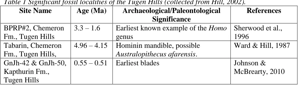
Table 1 Significant fossil localities of the Tugen Hills (collected from Hill, 2002).
Site Name Age (Ma) Archaeological/Paleontological Significance
References
BPRP#2, Chemeron Fm., Tugen Hills
3.3 – 1.6 Earliest known example of the Homo genus
Sherwood et al., 1996
Tabarin, Chemeron Fm., Tugen Hills,
4.96 – 4.15 Hominin mandible, possible Australopithecus afarensis.
Ward & Hill, 1987
GnJh-42 & GnJh-50, Kapthurin Fm., Tugen Hills
0.55 – 0.51 Earliest blades Johnson & McBrearty, 2010
The Baringo Basin-Tugen Hills area comprises the most complete late Neogene section
known from the African rift, with strata spanning the last 16 Ma (Chapman & Brook, 1978). The
Baringo Basin was selected for drilling by the Hominin Sites Paleolakes Drilling Project in order
to provide high stratigraphic continuity and resolution for identifying how shifting climate
patterns and orbitally-driven cycles influence environmental changes in the Rift Valley
(Campisano et al., 2017). In the stratigraphic interval targeted in the Chemeron formation
(5.3-1.6 Ma), approximately 100 fossil vertebrate localities including three hominin sites provide
opportunities to explore the mechanism of environmental change associated with shifting
insolation patterns; more specifically, examining lacustrine response to changing precipitation
patterns at precessional timescales to assess terrestrial community responses to pervasive,
short-term climatic change during the initiation of Northern Hemispheric glaciation (Kingston et al.,
2007; Wilson et al., 2014; Cohen et al., 2016). The diversification of hominin group
along with genus Homo, as well as earliest evidence for stone tool making are also observed in
this region (Harmand et al., 2015; Cohen et al., 2016).
Chemeron Formation tuffs stratigraphically bracketing hominin specimen KNM-BC 1, a
fossil hominin temporal bone of the genus Homo, were dated using single crystal 40Ar/39Ar and
resulted in the approximate range 2.456-2.393 Ma that is supported by stratigraphically
consistent horizons in nearby sections (Deino & Hill, 2002). This succession also contains cyclic
diatomite/fluvial cycles that are indicative of periodic freshwater, deep lake development (Deino
et al., 2006). These diatomites, termed the Barsemoi diatomites after the nearby Barsemoi River,
align with the orbital precessional interval of 23 kyr and are suggested to reflect intervals of
orbitally forced wet/dry climatic conditions; insolation models suggest that moisture originating
from the northern African monsoon fed the wet times of the record (Deino et al., 2006).The
Barsemoi diatomites provide an opportunity to relate short-term climatic changes to hominin
habitats and orbitally induced environmental change (Kingston et al., 2007).
1.2 Lake Baringo Basin – Tugen Hills
Modern Lake Baringo is a shallow freshwater lake located in a semi-arid volcanic region
on the eastern arm of the central Kenya Rift Valley. The modern lake and the adjoining Loboi
Swamp to the south represent the surface of a large (>5km) Pleistocene fault-controlled basin
(Renaut, 2000). Lake shape is controlled by the dominant N-S trend of the Tertiary-Holocene rift
system and the NW-SE oriented Precambrian metamorphic basement. These lineaments served
as major structural controls on Cenozoic extension of the East African Rift along with volcanic
damming of a river flowing through the rift valley (Yuretich, 1982; Dunkley et al., 1993; Le
Volcanism disrupted the drainage patterns of the eastern arm of the central rift, which helped
create small, shallow lake basins through new divides (Figure 1). This action diverted water
away from the rift and allowed high infiltration so lake development is restricted, explaining why
Baringo is such a shallow body of water. Despite the lack of surface outlet in a region of high
evaporation, Lake Baringo remains fresh due to subsurface loss of water through the lake floor
along with subsequent northward groundwater flows (Yuretich, 1982; Renaut, 2000). Although it
is currently a freshwater lake, Lake Baringo has dried up and become moderately saline due to
evaporative concentration at time during the past few thousand years (Owen, 1981; Renaut,
[image:19.612.75.393.332.448.2]2000).
Figure 1 Lake formation through volcanism (Yuretich, 1982)
The Tugen Hills is a structural horst within the Kenya Rift to the west of the modern lake
~1500m above the rift floor consisting of undifferentiated volcanic rocks and clayey soils
(Renaut 2000). The Tugen Hills were raised by the Saimo fault block of Neogene lavas,
sedimentary rocks, and tuffs which record a gradual eastern migration of the depocenter (Renaut,
2000; Deino et al., 2001; Kingston et al., 2007). Miocene troughs created the rift resulting in a
depositional basin housing widespread sedimentary sequences over the past 16 Ma (Chapman &
The Pliocene and Pleistocene Chemeron Formation is discontinuously exposed in the
eastern foothills of the Tugen Hills (Figure 2) and spans ~3.7 million years (5.3 – 1.6 Ma) of
strata (Kingston et al., 2007). The Chemeron Formation sediments overlie the Kaparaina Basalts,
and are truncated above by an angular disconformity at the base of the overlying Kapthurin
Formation (Figure 3). The Kapthurin and Chemeron Rivers that drain from the Tugen Hills
eastward to Lake Baringo expose the Chemeron formation. Chemeron sediments are mostly
composed of fine-grain terrigenous and lacustrine sediments containing mudstone and siltstone
with diatomite, sandstone, and conglomerate intercalations (Deino & Hill, 2002).
Figure 2 (A) Overview and (B) geologic map of Chemeron Formation, Tugen Hills with
BTB drill site labeled (modified from Deino et al., 2006). Cross sections and fossil localities
[image:20.612.75.505.330.625.2]Figure 3 Composite stratigraphy of the Tugen Hills succession (modified from Kingston
et al., 2007)
Using the ancient lake classification scheme for tectonic and climate controls from
Carroll and Bohacs (1999), core descriptions and mineralogy suggest paleolake Baringo
fluctuated between overfilled and balanced-filled lake basin types with lacustrine facies
associations changing from fluvial-lacustrine to fluctuating profundal facies associations.
Although in a region of high net evaporation and absence of a surface outlet, modern Lake
Baringo remains fresh due to subsurface loss of water through the lake floor coupled with
northward flow of groundwater, suggesting that the lake is topographically closed and
hydrologically open (Allen & Darling, 1992; Dunkley et al., 1993; Renaut et al., 2000).
Fluctuation in size and chemical composition has been explained as responses to short-term
seasonal changes to river and stream input (Allen & Darling, 1992), though changes in mineral
and lacustrine facies associations can be evidence for long-term changes caused by variations in
orbital forcings due to Milankovich cyclicty (Kingston et al., in review).
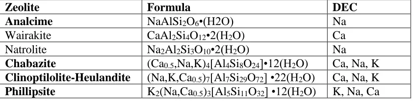
1.3 Zeolite Diagenesis
The zeolite group of minerals are framework aluminosilicates that are commonly
hydrated, and have alkali cation compositions (Klein and Dutrow, 2007). Authigenic zeolite
formation is primarily the byproduct of volcanic glass deposited in saline-alkaline waters (Hay,
1970; Hay & Sheppard, 2001). The zeolite crystals typically contain open cavities in the form of
channels and cages, usually occupied by H2O molecules and extra-framework cations that are
commonly exchangeable, and large enough to allow the passage of guest species (Lauf, 2014).
Table 2 lists the four major zeolites found throughout the BTB core material (in bold), as
well as minor zeolites, with their chemical composition and Dominant Extra Framework Cation
(DEC). The most critical requirement for zeolite formation is a high aqueous activity ratio of
(Na+ + K+ + Ca2+)/H+. Because of this, zeolites are formed predominantly in alkaline
environments, with the larger concentrations of pure zeolites found primarily in altered vitric
Table 2 Schematic chemical formulae of primary zeolites. DEC = Dominant Extra framework Cation (modified from Passaglia & Shepphard, 2001)
Zeolite Formula DEC
Analcime NaAlSi2O6•(H2O) Na
Wairakite CaAl2Si4O12•2(H2O) Ca
Natrolite Na2Al2Si3O10•2(H2O) Na
Chabazite (Ca0.5,Na,K)4[Al4Si8O24]•12(H2O) Ca, Na, K
Clinoptilolite-Heulandite (Na,K,Ca0.5)7[Al7Si29O72] •22(H2O) Ca, Na, K
Phillipsite K2(Na,Ca0.5)3[Al5Si11O32] •12(H2O) K, Na, Ca
Water activity and pore-fluid composition are significant factors in determining zeolite
formation. Because the activity of water is reduced at high ionic strength, higher salinity lowers
solute temperatures of dehydration and consequently lowers the temperatures at which the less
hydrous zeolites are stable (Hay, 1966; Sheppard & Hay, 2001). The proportions of
extra-framework cations are also critical in determining which zeolites may form dependent on cation
availability. A unique trait defining the zeolite group is the ability to hydrate and dehydrate
reversibly during cation exchange between aqueous bodies while resisting major structural
changes (Pabalan & Bertetti, 2001). Based on these characteristics, the composition of the
dominant extra-framework cations (DECs) of lacustrine zeolites are potentially important
indicators for the geochemistry of paleolake waters.
1.4 Plio-Pleistocene East African Paleoclimate
The essential factors that comprise the creation of monsoons, as stated by Webster, 1987,
are the following: “(1) the differential seasonal heating of the oceans and continents, (2) moisture
processes in the atmosphere, and (3) the earth’s rotation”. Differences between the East and West
African Monsoon systems are affected by the shape of the continent, rainfall variability caused
monsoon flows, and influences from the Indian monsoon, in addition to the three factors stated
above (Davies et al., 1985; Nicholson, 1996; McGregor and Nieuwolt, 1998). Major structural
elements of the East African Monsoon system include the ITCZ traveling south of the equator,
the Arabian and Mascarene high pressure systems, the East African low level jet stream, West
African mid-tropospheric jet stream, the tropical easterly jet stream, and the two subtropical
westerly jet streams (McGregor and Nieuwolt, 1998). The rate of moisture transport over East
Africa and strength of monsoonal flows are attributed to the two major monsoon wind systems
dominating East Africa, which includes the north-easterlies and the south-easterlies, both
anticyclones that vary in intensity, location, and orientation (McGregor and Nieuwolt, 1998).
The above describes the modern East African Monsoon system, however Plio-Pleistocene
climate variability in this region has been studied through eolian dust from marine sedimentary
sequences for the past ~5 Ma (Rea, 1994; deMenocal, 1995). Plio-Pleistocene climate changes in
East African must be evaluated in relation to high latitude climate changes, as seen in marine
oxygen isotope data recording the onset of high latitude glacial cycles being gradually develop
between 3.1-26 Ma (Shackleton et al., 1990; Tiedemann et al., 1994; deMenocal 1995). Previous
studies reveal the African climate response to precessional insolation forcing in high and low
latitude processes observed during the initial growth and expansion of high latitude ice sheets
around 2.8 Ma and 1.0 Ma, respectively; prior to 2.8 Ma the ice sheets were small and relatively
constant (Shackleton et al., 1984, 1990; Clemens and Prell, 1991; Jansen and Sjoholm, 1991;
deMenocal et al., 1993; Tiedemann et al., 1994; deMenocal, 1995). Because terrestrial
paleoclimate data for this time interval have not been recorded as extensively as marine records,
the most accurate characterization Plio-Pleistocene African climate can be described as a
variability occurring around 2.8, 1.7, and 1.0 Ma; these findings are observed as the development
of cool, dry conditions after 2.8 Ma followed by the intensification after 1.7 and 1.0 Ma
(deMenocal 1995).
1.5 Hypothesis Testing
Past climate reconstruction for this area have been based on outcrops along lake margins
or have used marine climate proxies. The lack of abundant biogenic material in the core (other
than within diatomite intervals) presents a challenge for paleoclimate reconstruction.
Development of these zeolite indicators will contribute a useful set of tools of terrestrial climate
proxies for lacustrine systems.
The purpose of this thesis is to test whether major environmental changes in the Baringo–
Tugen Hills Basin are represented by trends in the mineralogy of lacustrine sediment. These
changes will then be compared to models of orbital variations thought to affect East African
paleoclimate in Plio-Pleistocene time, particularly those emphasizing the role of eccentricity in
climate control.
Identifying the mineralogy throughout core material collected from the HSPDP Tugen
Hills drilling campaign and comparing the trends identified to previous outcrop and marine
paleoclimate proxy studies will test this hypothesis.
2 MATERIALS AND METHODS 2.1 Site selection, coring, and initial core descriptions
In order to minimize the likelihood of encountering subsurface faults or associated
deformation that might interfere with maximizing stratigraphic resolution, survey data were
Baringo/Tugen Hills pre-drilling information was based on known outcrop exposures
immediately adjacent to the drill site whereas other HSPDP sites used seismic, gravity, and
magnetic surveys (Deino et al., 2006; Kingston et al., 2007; Cohen et al., 2016).
HSPDP personnel began drilling June 1, 2013 and successfully recovered a ~227m core.
Vertical drilling was possible at the Baringo Basin/Tugen Hills site due to the existing ~20 ° dip
of sediments. Geophysical down-hole logging data were collected for natural gamma, magnetic
susceptibility (MS), resistivity, borehole temperature, and azimuthal direction (Cohen et al.,
2016). MS data were collected from unsplit cores using a multisensory core logger (MSCL,
Geotek Ltd.) (Cohen et al., 2016). The core was recovered ~20m from cliff exposures of
Chemeron sediments and contains a sedimentary record similar to that known from outcrop
studies. The sampling identification system consisted of the project initials (HSPDP), followed
by the site name (BTB), then the site hole (1A), core drilled and tool used for drilling (1-81 &
Q/Y), section of core (1, 2, 3 or CC) and finally the sediment range in a 2cm interval; example
being HSPDP-BTB-1A-32Q-2_33.5-35.5.
The core was subsequently transported to the National Lacustrine Core Facility
(LacCore) at the University of Minnesota for scanning, processing, initial core descriptions, and
subsampling every 16cm (Cohen et al., 2016). Physical properties of the core were analyzed in
detail via MSCL-S for p wave locality, gamma density, loop MS, non-contact electrical
resistivity, and natural gamma radiation, and MSCL-XYZ for high resolution MS and color
reflectance spectrophotometry at 0.5-4cm increments (Cohen et al., 2016). MSCL-CIS digital
linescan core imager provided imagery once cores were split in half lengthwise and cleaned
The borehole was located near the cyclic diatomites and mudstone outcrops of the upper
Chemeron Formation, which were previously shown to reflect precessional climate variability
during the Plio-Pleistocene transition (Deino et al., 2007; Kingston et al., 2007; Cohen et al.,
2016). Sediments are dominantly fluviolacustrine and floodplain paleosols in the lower half of
the core, with cyclic deep-lake diatomites and subaerially deposited sediments in the upper half,
spanning approximately 3.4-2.6 Ma (Kingston et al., 2007; Kingston et al., in review).
2.2 Mineralogy
At Georgia State University, 1078 samples were oven dried at 40°C for 48 hours, then
ground to fine powder using ball & pestle impact grinders or by hand using mortar and pestle,
depending on hardness of material. The bulk mineralogy of core material was analyzed by
powder X-ray diffraction (XRD) using a Panalytical X’pert Pro MPD using CuKα radiation, in
the range 5-60°2θ, operating at 45kV and 40mA for a duration of 30 minutes. HighScore+ and
Data Viewer software used for mineralogical analysis (Panalytical 2012). 1078 samples were
analyzed for mineralogical identification.
Mineralogical identification through XRD consisted of generating mineral ID’s from the
HighScore+ database and selecting the most applicable match per diffraction peak. These
matches were then confirmed through consulting references by hand through d-spacing and 2θ
coordinates specific to each mineral (Brindly and Brown, 1980; Moore and Reynolds, 1989).
Mineral occurrence determined from XRD analysis was recorded in a Microsoft Excel
spreadsheet listed by relative abundance for the corresponding sample ID (Appendix A). Major
XY scatter plots. Age model was created through running stratigraphic heights (mbs) through a
Table Interpolation program created by A. Deino at a 97.5% confidence interval.
After mineral identification through XRD, 15 representative samples were selected for
scanning electron microscope (SEM) and energy-dispersive spectroscopy (EDS) analysis to
provide textural and compositional data for major zeolite facies. Selected samples were carbon
coated, and analyzed on a Tescan Vega3 SEM with an EDAX element X-ray detector running
Team software, with an accelerating voltage of 10kV with approximately 1nA probe current.
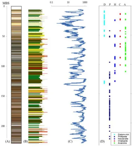
3 RESULTS 3.1 Stratigraphic Variation
The top ~50m of the core contain five diatom-rich intervals (8.73-11.10, 15.10-22.16,
25.22-32.31, 41.52-43.47, and 50.18-52.04 meters below surface) that appear to be the upper
Barsemoi Diatomites of Deino et al. (2006). These diatomites have been previously interpreted
to record episodic expansions of freshwater lake systems driven by orbital precession (Deino et
al., 2006; Kingston et al., 2007). Because biotic proxies are poor outside of these diatom-rich
intervals, bulk mineralogical analysis identifies a variety of mineral assemblages from
sedimentary sequences nearly exclusive from these diatom-rich zones.
A wide array of alkali and plagioclase feldspars, silica polymorphs, Fe-oxides, Ti-oxides,
carbonates, sulfur-bearing minerals, clay minerals, and zeolites are found in abundance
throughout the core. Albite, anorthite, and anorthoclase seem to occur sporadically throughout
the entire sequence. Silica polymorphs include cristobalite, tridymite, and quartz, as well as
opaline silica. Hematite is the most abundant Fe-oxide, although magnetite and magnesioferrite
have been identified in lesser amounts. Rutile and anatase are the identified Ti-oxides. Nodular
and pyrite are seen in individual samples spread across the upper-middle section of the core.
Smectite or kaolinite are present in many samples, although detailed clay mineralogical studies
on oriented slides have not yet been carried out. Most notably, the distribution of zeolite mineral
species forms distinct zones throughout the core. Although zeolites have been noted in the basin
before (Renaut et al., 2000; Kerrich, 2002; Ashley et al., 2006) this distinct zonation has not
Figure 4 (A) Core color, (B) lithology, and (C) magnetic susceptibility (MS) log data
(25-point running mean smooth) from LacCore Geotek XYZ (25-point sensor data (modified from Cohen
[image:30.612.78.503.71.544.2]Figure 5 Key to lithological symbols (Cohen et al., 2016)
3.2 Zeolite facies
Although occurrences are variable, facies have been identified for the following zeolite
mineral groups up-section, respectively: phillipsite, clinoptilolite-heulandite, chabazite, and
analcime. Although other zeolite minerals such as wairakite, natrolite, and mordenite are also
found throughout the core, these minerals are subordinate to the other major zeolties, and so are
grouped into the facies stated according to their framework type and dominant extra-framework
3.2.1 Phillipsite facies
Phillipsite is identified in 105 samples and is the most abundant zeolite found in
Tugen Hills core material through X-ray diffraction. The phillipsite facies dominates the
lower 130m of the core. Phillipsite is also observed in other facies, such as co-occurring
with diatomaceous material and other zeolites. A return of the phillipsite facies occurs at the
interval 113.35-123.82mbs after clinoptilolite first appears, associated with the deepest
observed diatomite (Kingston et al., 2007) and again 67.56-65.50mbs, above which the
analcime and chabazite facies dominate (Figure 4). XRD, SEM, and EDS indicate that
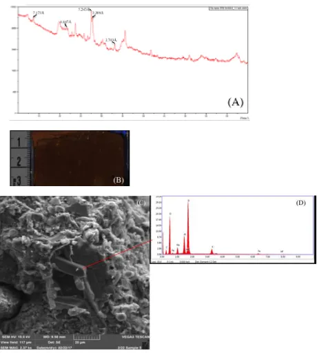
Figure 6 Analysis of philipsite-bearing sample BTB-1A-65Q-2_1-3 (187.73 mbs): (A)
diffractogram showing peaks labeled with respective d-spacings, (B) core image described as
“orange-brown mottled bioturbated silty clays, some relict bedding, almost completely
depositional environment” (C) SEM image depicting rectangular phillipsite crystals within a
clay matrix, (D) EDS spectrum of phillipsite showing the chemical composition with cations K
and Na, major elements of silicate framework Si, O, and Al, trace amounts of Fe, Hf, and C
identified in reading attributable to the instrument error and carbon coating process for sample
3.2.2 Clinoptilolite-heulandite facies
At ~128 mbs, the basal phillipsite facies transitions to the overlying clinoptilolite
facies, associated with an interval of the diatomite facies. Although different species of
clinoptilolite and heulandite are difficult to distinguish through X-ray diffraction alone, slightly
varying diffractogram peaks throughout the core suggest both minerals occur at various depths
(Figure 7). Clinoptilolite-heulandite underlies the analcime (110.88-113.8mbs) and chabazite
(100.56-101.64mbs) facies as and co-occurs with all major zeolites and diatom-rich intervals.
(B)
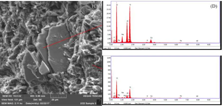
Figure 7 Analysis for heulandite-bearing sample BTB-1A-31Q-2_23.5-25.5 (87.48 mbs):
(A) diffractogram showing peaks labeled with respective d-spacings, (B) core image described
as “medium brown, medium grain sands, disconformably overlies finegrained lacustrine unit
below due to loss of intermediate bedding by channeling and cross cutting represented by this
sandy unit, (C) SEM image depicting tabular heulandite crystal fragments in a clay matrix, (D)
EDS of heulandite with Ca and Na DEC with trace K and Fe (top) and Al-rich clay with trace
Na, Mg, Fe, K, and Ca (bottom).
3.2.3 Chabazite facies
The majority of core material samples containing chabazite also contain other zeolite
minerals, most notably, but not exclusively, analcime, clinoptiolite, and phillipsite. The
chabazite facies begins at approximately 101mbs and is often interbedded with the analcime
facies showing intermittent and simultaneous occurrences of both minerals. The termination of
the chabazite facies is interbedded with the analcime facies in the interval between diatomites 4
samples spanning approximately 87m throughout the core. SEM and EDS analyses identify
[image:37.612.69.535.154.626.2]chabazite associated with Al-rich clay (Figure 8).
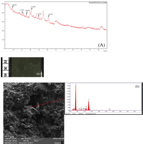
Figure 8 Analysis for chabazite-bearing sample BTB-1A-23Q-1_33.5-35.5 (64.83 mbs):
(A) diffractogram showing peaks labeled with respective d-spacings, (B) core image described
sediment deformation (possibly earthquake liquefaction events), few scattered laminae of coarse
material, some calcite nodules, vivid green appears to mean weathered volcanic glass (C) SEM
image showing cubic chabazite crystals among clay and possibly weathered wairakite, (D) EDS
analysis describing the chemistry of chabazite containing Ca and Na with trace Mg.
3.2.4 Analcime facies
The Na-dominated analcime facies is the second most abundant in the BTB core.
Although sharing a similar depth range with chabazite, spanning approximately 88m, the
analcime facies is four times as common with 99 samples identified. Samples belonging in this
facies contain mostly analcime with minor other related zeolites such as wairakite and natrolite.
Wairakite shares a structure type with analcime although having Ca as the DEC, whereas
natrolite shares Na as the respective DEC while belonging in a different structure type than
analcime. X-ray diffraction evidence of high zeolite crystallinity is attributable to the abundance
of euhedral analcime visible through SEM imagery (Figure 9). Although work is underway to
examine the clay mineralogy in more detail, elevated levels of Mg relative to other observed
intervals studied through EDS analyses suggests Mg-rich clay occurring with analcime at
81.81mbs in sample BTB-1A-28Q-1_141.5-143.5 (Figure 9). This facies onset occurs within the
early clinoptilolite-heulandite facies and immediately above the termination of a phillipsite facies
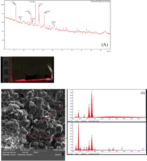
Figure 9 Analysis for analcime-bearing sample BTB-1A-28Q-1_141.5-143.5 (81.18
mbs): (A) diffractogram showing peaks labeled with respective d-spacings, (B) core image
described as “dark black-grey course sand matrix, poorly sorted, small clasts, huge lithic
bedding with some bands of coarse grained material and some beds of grey and brown finer
grained materials, bioturbation and mixed up bedding depositional environment, lithic zones
most likely subaerial (C) SEM imagery depicting euhedral analcime crystals with clays, (D) EDS
of analcime (top) occurring with clays consisting of Mg, Na, Ca, Fe, Ba, Ti, and P (bottom).
3.2.5 Diatomite facies
Diatomaceous material can be found throughout the majority of the top 50m of the core
as well as a deeper interval around ~130mbs. The diatomites are typically zeolite-free intervals
that only contain detrital clay mineral assemblages and opaline silica represented by diffuse
diffraction peaks. In some cases diatomaceous sediments co-occur with all major zeolites at
various depths. The deepest diatomite (~132-128mbs) marks the beginning of the first facies
transition up-section with the occurrence of clinoptilolite at 129.05mbs at the top of the
phillipsite facies. The remaining diatomites, termed diatomites 1-5 by Kingston et al. 2007, span
approximately ~40.94m throughout the upper section of the core as mostly zeolite-free zones,
with the exception of diatomites 1 and 2 existing in transitional facies associations. Diatomite 1
contains phillipsite, clinoptiolite-heulandite, chabazite, and analcime from samples observed
Figure 10 (A) Core and (B) SEM images from diatomite bearing sample
BTB-45Q-1_33.5-35.5 (128.81 mbs).
4 DISCUSSION
4.1 Geochemical evolution of the Lake Baringo Basin & Paleohydrology
4.1.1 Zeolite geochemistry
Like most zeolites, volcaniclastic sediment accumulations of phillipsite, are generally
alteration products replacing volcanic glass following reactions with alkaline waters. Phillipsite
is found in a variety of geologic settings, but particularly in cavities of basaltic rocks replacing
tuffs and abundant in deep ocean sediments (Lauf, 2014). Thermodynamic modeling of
representative zeolite minerals found in saline-alkaline lakes (Figure 11A) shows phillipsite is
stable at lower silica activities and is replaced by K-feldspar at elevated K+ concentrations.
(Chipera and Apps, 2001). The phillipsite facies is representative for waters with relatively low
[image:41.612.328.534.68.309.2](Kastner and Stonecipher, 1978; Stonecipher, 1978; Chipera and Apps, 2001; Deocampo and
Jones, 2013).
Although clinoptilolite has a higher Si:Al ratio than heulandite (5.7 & 2.6, respectively),
these minerals form a series and share many common identifiers, including XRD peak positions,
DEC, and tetrahedral composition (Passaglia & Sheppard, 2001; Bish & Boak, 2001). These
species cannot be easily distinguished based on X-ray powder diffraction alone due to difficulty
in determining unit-cell parameter to changes in water content (Bish, 1984; Bish & Boak, 2001).
For these reasons and for the purpose of this study, these minerals are combined into a single
facies that occurs immediately after the phillipsite facies. Dominant extra-framework cations
(DEC) for the series are primarily Ca-dominant, followed by Na and K, differing from the
underlying phillipsite facies with DEC of K, Na, and Ca. The clinoptilolite-heulandite facies is
the first transition facies between K-rich phillipsite and Na-rich Analcime, sharing properties
with the basal phillipsite facies associated with deep-water conditions (Kastner & Stonecipher,
1978; Stonecipher, 1978; Chipera & Apps, 2001). The introduction of this facies suggests drastic
environmental change with fluctuations to chabazite, analcime, and phillipsite facies throughout
the rest of the core as represented by the sudden variations in mineralogy.
Chabazite is one of the most widespread natural zeolites with a variety of reported
occurrences, such as vugs from plutonic rocks, volcanic, and metamorphic rocks, as well
forming with association of many other zeolites, including, but not limited to analcime,
heulandite-clinoptilolite, mordenite, and phillipsite (Passaglia & Sheppard, 2001). Sedimentary
chabazite occurs in pyroclastic rocks diagentically altered in continental environments in both
mordenite, and clay minerals (Passaglia & Sheppard, 2001). Chabazite shares DEC with the
underlying clinoptilolite-heulandite facies Ca, Na, & K.
The analcime facies abundance and occurrence intervals throughout the core are
suggestive for the highest concentration of brines and lack of availability of remaining non-Na
cations. Regardless of silica saturation, analcime occurrence is dependent on Na availability
relative to K & Ca.
Zeolite mineral assemblages are identified as varying facies occurring throughout the
core. The behavior and pattern of these assemblages observed can be placed into distinct “zones”
or certain depth intervals sharing similar variation in zeolite facies. Coupled with a geochemical
stability diagram for zeolites occurring in saline-alkaline lacustrine systems, adapted from
Chipera and Apps 2001, these zones are able to identify the geochemical history of the paleolake
through K/Ca and Na/Ca ratios (Figure 11). Figure 11A shows zones depicted as color coded
circles and numbers that illustrate the extent of the geochemistry of the paleolake. The range of
stabilities for each mineral allows for identification of the geochemical history of paleolake
(C)
Figure 11 Thermodynamic stabilites for zeolites insaline-alkaline lake systems (modified from Chipera and Apps, 2001) with zones labeled as numbered color coded circles, (B) zone
The largest zone, Zone 1, occupies nearly the entire lower half of the observed core
spanning 111.18m (116.12-227.3mbs) with primarily the phillipsite facies. The onset of the
clinoptilolite-heulandite facies occurring with the deepest diatomite around 129mbs is also
present in zone 1. Zone 1 appears to be most geochemically stable interval until the diatomite
occurrence at, reflecting indicators suggestive of environmental change. Zone 2 shows more
variation in geochemical activity with all major zeolite facies occurring in the interval
87.72-116.12mbs, without diatom-rich material being observed. Zone 3 is similar to zone 1 for having a
singular zeolite facies occupy a significant depth interval (70.18-87.72mbs) without the other
major facies. Analcime is the only zeolite observed in zone 3; Na enrichment through depletion
of Ca & K suggested by an absence of all other major facies indicative of geochemically stable
conditions. The chabazite and clinoptilolite-heulandite facies are reintroduced in zone 4
(51.41-70.18mbs) without the phillipsite and diatomite facies. All major facies are observed in the top
49.15m of the core in Zone 5 (5.26-51.41mbs), including the Barsemoi diatomites (Deino et al.,
2006; Kingston et al., 2007). A path can be constructed when coupling zones with the
geochemical stabilities of the major zeolites, as seen in Figure 10. The lower part of the core can
be interpreted as K-rich and Ca-poor with very high K/Ca and moderately high Na/Ca ratios,
where the path begins on the K saturated boundary of the diagram. Traveling up-section through
the core can be also observed as increasing Na/Ca and decreasing K/Ca with zones 2 and 3.
Na/Ca decreases in zone 4 until the phillipsite facies reoccurrence in zone 5 with increasing
K/Ca and Na/Ca.
The overall observed trend in mineralogy up-section, containing periods of increasing
and decreasing Na/Ca and K/Ca ratios, depicts cyclical behavior in the paleolake basin
tectonic sources, though climatic hypothesizes are being tested through these studies (Kingston
et al., in review).
4.1.2 Paleohydrology
Geochemical evolution observed through mineralogical trends found in core material has
the ability to be indicative of paleohydrological behavior in response to suggested climatic
changes. The pattern created by zoning reflects increasing concentrations and compositional
changes of surface and groundwater brines, along with increasing distance from sediment
sources (Sheppard & Gude, 1968; Cohen, 2003). This allows analcime observed in core material
to provide insights into the paleohydrological conditions of the lake using analcime occurrence
as an indicator of increased salinity due to higher concentration of brines.
Paleolake Baringo is thought to have experienced salinity fluctuations based on zeolite
facies intervals with representative DEC trending upsection from K-dominated to Na-dominated
(Figure 11). The phillipsite facies can be observed during intervals of relatively deeper, fresher
conditions with higher P/E ratios, with K+ mostly remaining in solution and not precipitating
into authigenic minerals such as authigenic illite or K-feldspar (Hover and Ashley, 2002;
Deocampo and Jones, 2013). The extent of the paleolake, inferred by cation availability recorded
through zeolite occurrence, is able to determine the lake basin-type as well as salinity (Caroll &
Figure 12 Ancient Lake Classification System (Carroll and Bohacs, 1999)
4.2 Implications for paleoclimate
Past climate reconstruction studies for Tugen Hills (Renaut et al., 2000; Ashley et al.,
2006; Deino et al., 2006; Kingston et al., 2007; Trauth et al., 2010; Wilson et al., 2014) have
been based on outcrops found along the lake margins and are not as continuous as the core
material recovered through the HSPDP campaign. The Barsemoi diatomites in the upper portion
of the core indicate that periods of deep-water conditions were associated with extreme wet/dry
cycles, orbitally forced by precession at a time of peak eccentricity (Deino et al., 2006; Kingston
et al., 2007). Regional paleoclimate studies for East Africa support claims of variability caused
by orbital forcing through statistical methods and are removing inconsistencies between marine
and other terrestrial records (deMenocal, 1995; Trauth et al., 2009).
The paleoclimate interpretation of Eastern Africa using mineralogical methods yields the
important factor of variability. The occurrence in depth of authigenic zeolite mineral facies proxy
as indicators recording sediment geochemistry changes through time. A perspective when
from the increase in alkaline minerals and salinity. The Na/Ca increase is clearly noted through
zone 3 as well as an overall abundance of the analcime facies. However, a single facies
occurrence cannot determine climate conditions on its own. Facies are indicative of the
sedimentary environment through the mineralogical scope at regional scales, but the zonation of
facies’ occurrence in depth and the variation of assemblages provide helpful information for
determining the paleoenvironmental conditions.
While aridity intervals occur more frequently up-section, higher variability increases as
well; especially in the intervals surrounding the diatomite facies. Ca is often below detection
limits in saline-alkaline lake systems due to its removal through sulfates and carbonates, while
Na and K can reach high concentrations (Chipera & Apps, 2001). Ca-dominant zeolites, such as
chabazite, clinoptilolite, and heulandite, may be identified in the core as transitional periods
indicating rapid environmental change from K-rich phillipsite to Na-rich analcime. The sequence
of the Barsemoi diatomites, indicating humid climates with deep lake levels, contradicts the
overall trend of aridity increase when only noting the Na/Ca ratio increase with the analcime
facies. Singular trends in mineralogy are not strong enough to understand the overview of
climatic behavior, although the spatial relationship and variability between facies may be
suggestive of less stable conditions with more environmental change. Zones 2, 4, and 5 can be
indicative of episodes experiencing changes in the environmental conditions reflected by the
geochemical stabilities of the zeolite facies assemblages. Zones 1 and 3 are indicative of more
stable environmental conditions; the abundance of primarily phillipsite may be interpreted as a
humid period, whereas zone 3 provides insight into the increased saline conditions of the
the diatomite facies, suggesting rapid environmental change with varying DEC occurring
simultaneously.
Figure 13 (A) Eccentricity, (B) precession, and (C) insolation curves (Laskar et al, 2004)
compared to (D) zeolite facies occurrence plotted to age (Ma) with mineral zones shown. Dated
tuff horizons (Table 3) marked as (*).
Age
(Ma
[image:49.612.80.512.160.503.2]Table 3 40Ar/39Ar tuff dates reported by Denio et al., 2006, with depth in the BTB core material using Table Interpolation age model, courtesy of Alan Deino.
Depth (mbs) Dated Tuff Horizon Age (Ma)
5.74 – 6.23 2.587 (±0.005)
7.90 – 8.38 2.590 (±0.003)
61.62 – 62.10 2.718 (±0.005)
90.26 – 90.59 2.903 (±0.012)
Facies distribution plotted to age, rather than depth, tells nearly the same mineralogical
story. The observed core holds a highly resolved stratigraphic record of the last events of the
Pliocene leading to the onset of glaciation periods in the Pleistocene. The first facies transition
event observed in the core, heulandite with the deepest diatomaceous material, approximately
occurs during a global cooling trend around 3.07-3.09 Ma (Figure 12). The interval between the
diatom-rich zones ~3.1-2.7 Ma depicts various zeolite mineral occurrences individually and
simultaneously relative to other facies. Unstable conditions can be identified through periods of
multiple facies such as zones 2, 4, and 5. These zones may be indicative of extensive
environmental change reflected by varying lake paleochemistry. Zones 1 and 3 primarily exhibit
stable environmental conditions. Zone 1 is K+ rich being dominated by the phillipsite facies until
heulandite is observed occurring with the deepest diatomite. Zone 3 is Na+ rich with the analcime
facies dominating, occurring prior to the Plio-Pleistocene boundary and the Barsemoi diatomites.
Zone 3 is also a period of minimal eccentricity, precession, and insolation differences. The
cyclical behavior of stable-unstable conditions might suggest rapid environmental changes
5 CONCLUSIONS
The mineralogical record observed from the HSPDP Tugen Hills drill core material holds
a highly resolved stratigraphy data spanning events leading to the Plio-Pleistocene boundary
(~2.58 Ma). X-ray diffraction and scanning electron microscope analyses have been used to
identify the mineralogical behavior of the Baringo paleolake. The trends in zeolite mineralogy
depict a pattern of stable and unstable paleoenvironmental conditions through distinct zones and
facies assemblages. The lower portion of the core, zone 1, is indicative of stable environmental
conditions until the transition to the clinoptilolite-heulandite facies occurring ~3.1 Ma (128mbs).
The overlying zone 2 features the other major zeolite facies, clinoptilolite-heulandite, chabazite,
and analcime, occurring simultaneously in the absence of diatomaceous material. Zone 3,
populated primarily by the analcime facies, represents a relatively stable interval, likely with
more saline lake waters. The observed interval is comparable to extensive periods of a single
facies as observed in zone 1. The upper portion of the core, zones 4 and 5, represent the
following period of instability and high amplitude of environmental change.
The overall trend observed in the core paleochemistry depicts a decrease in K/Ca and an
increase in Na/Ca, with major fluctuations in between for facies transitions. Major environmental
change recorded through mineralogy can be expressed as mineral zones, and used to infer the
chemical changes in the basin.
Georgia State University is currently undergoing analysis for clay mineralogy through
X-ray diffraction for selected intervals in each zone. Specific transitions observed may provide
REFERENCES
Allen, D.J., Darling, W.G. 1992. Geothermics and hydrogeology of the Kenya Rift Valley
between Lake Baringo and Lake Turkana. British Geology Survey Research Report SD/92/1, 39.
Ashley, G.M., Maitima Mworia, J., Muasya, A.M., Owen, R.B., Driese, S.G., Hover,
V.C., Renaut, R.W., Goman, M.F., Mathai, S., Blatt, S.H. 2004. Sedimentation and recent
history of a freshwater wetland in a semi-arid environment: Loboi Swamp, Kenya, East Africa.
Sedimentology, 51, 1301-1321.
Ashley, G.M., Hover, Victoria, C., Driese, S.G., Roure, C.A., McBrearty, S., Owen, R.B.,
Renaut, R.W. 2006. A Changing Landscape in the semi-arid tropics: insights from paleosols,
East Africa Rift, Kenya. Geological Society of America Abstracts with Programs, 38, 7, 531.
Amaoui, N., Hollnack, D. 2003. Neotectonics and extension direction of the Southern
Kenya Rift, Lake Magadi area. Tectonophysics, 364, 71-83.
Bish, D.L. 1984. Effects of exchangeable cation composition on the thermal
expansion/contraction of clinoptilolite. Clays & Clay Minerals, 32, 444-452.
Bish, D.L., Boak, J.M. 2001.Clinoptilolite-Heulandite Nomenclature, in: Bish, D.L.,
Ming, D.W. (Eds.), Natural Zeolites: Occurrence, Properties, Applications, The Mineralogical
Society of America, Washington, DC, 45, 207-216.
Brindly, S.W., Brown, G. 1980. Crystal structure of clay minerals and their X-ray
diffraction. Mineralogical Society, London.
Carroll, A.R., Bohacs, K.M. 1999. Stratigraphic classification of ancient lakes: Balancing
Chipera, S.J., Apps, J.A. 2001. Geochemical Stability of Natural Zeolites, in: Bish, D.L.,
Ming, D.W. (Eds.), Natural Zeolites: Occurrence, Properties, Applications, The Mineralogical
Society of America, Washington, DC, 45, 118-161.
Campisano, C. et al. 2017. The Hominin Sites and Paleolakes Drilling Project:
High-Resolution Paleoclimate Records from the East African Rift System and Their Implications for
Understanding the Environmental Context of Hominin Evolution. PaleoAnthropology 2017:1-43
Chapman, G. R., Brook, M. 1978. Chronostratigraphy of the Baringo Basin, Kenya, in:
Geological background to fossil man, edited by: Bishop, W. W., Scottish Academic Press,
London, 207–223.
Clemens, S.C., Prell, W.L. 1991. One million year record of summer monsoon winds and
continental aridity from the Owen Ridge (site 722), northwest Arabian Sea. Proceedings of the
Ocean Drilling Program, Scientific Results, 117, 21, 365-388.
Cohen, A. 2003. Paleolimnology: The History and Evolution of Lake Systems. Oxford,
New York. 230-231.
Cohen, A., Ashley, G.M., Potts, R., Behrensmeyer, A.K., Feibel, C., Quade, J. 2006.
Paleoclimate and human evolution workshop. EOS Transactions AGU 87, 161,
doi:10.1029/2006EO160008
Cohen, A., Umer, M. 2009. Connection scientific drilling and human evolution. EOS
Transactions AGU 90, 122-122, doi: 10.1029/2009EO140010.
Cohen, A. et al. 2009. Understanding Paleoclimate and Human Evolution Through the
Hominin Sites and Paleolakes Drilling Project, Scientific Drilling, 8, 60–65,
Cohen, A. et al. 2016. The Hominin Sites and Paleolakes Drilling Project: inferring the
environmental context of human evolution from eastern African rift lake deposits. Scientific
Drilling, 21, 1-16. doi:10.5194/sd-21-1-2016.
Davies, T.D., Vincent, C.E., Beresford, A.K.C. 1985. July-August rainfall in
West-Central Kenya. International Journal of Climatology, 5, 1, 17-33.
Deino, A.L., Hill, A. 2002. 40Ar/39Ar dating of the Chemeron Formation strata
encompassing the site of hominin KNM-BC 1, Tugen Hills, Kenya. Journal of Human Evolution,
42, 141-151, doi: 10.1006/jhev.2001.0522.
Deino, A.L., Kingston, J.D., Glen, J.M., Edgar, R.K., Hill, A. 2006. Precessional forcing
of lacustrine sedimentation in the late Cenozoic Chemeron Basin, Central Kenya Rift, and the
calibration of the Gauss/Matuyama boundary. Earth and Planetary Science Letters, 247, 41-60.
Dunkley, P., Smith, M., Allen, D., Darling, W. 1993. The geothermal activity and
geology of the northern sector of the Kenya Rift Valley. British Geological Survey Research
Report SC/93/1, 185.
Harmand, S. et al 2015. 3.3 million year old stone tools from Lomekwi 3, West Turkana,
Kenya, Nature, 521, 310–315, doi:10.1038/nature14464.
Hay, R.L. 1966. Zeolites and zeolitic reactions in sedimentary rocks. Geological Society
of America Special Papers, 85, 130.
Hay, R.L. 1970. Silicate reactions in three lithofacies of a semi-arid basin, Olduvai
Gorge, Tanzania. Mineralogical Society of America Special Paper, 3, 237-255.
Hay, R.L., Sheppard, R.A. 2001. Occurrence of Zeolites in Sedimentary Rocks: An
Overview, in: Bish, D.L., Ming, D.W. (Eds.), Natural Zeolites: Occurrence, Properties,
Hill, A. 1985. Early hominid from Baringo, Kenya. Nature, 315, 6016, 222-224.
Hill, A. 2002. Paleoanthropological research in the Tugen Hills, Kenya. Journal of
Human Evolution, 42, 1-10.
Hover, V.C., Ashley, G.M. 2003. Geochemical signatures of paleodepositional and
diagenetic environments: a STEM/AEM study of authigenic clay minerals from an arid rift basin,
Olduvai Gorge, Tanzania. Clays and Clay Minerals, 51, 231-251.
Jansen, E., Sjoholm, J. 1991. Reconstruction of glaciation over the past 6 Myr from
ice-borne deposits in the Norweigian Sea. Nature, 349, 600.
Johnson, C.R., McBrearty, S. 2010. 500,000 year old blades from the Kapthurin
Formation, Kenya. Journal of Human Evolution, 58, 2, 193-200.
Kastner, M., Stonecipher, S.A. 1978. Zeolites in pelagic sediments of the Atlantic,
Pacific, and Indian Oceans, in: Sand, L.B., Mumpton, F.A. (Eds.), Natural Zeolites: Occurrence,
Properties, Use. Pergamon Press, New York, 199-220.
Kerrich, R., Renaut, R.W., Bonli, T. 2002. Trace-element compostion of cherts from
alkaline lakes in the east African rift: a probe for ancient counterparts. SEPM Special
Publication, 73, 275-294.
King, B.C. 1978. Structural and volcanic evolution of the Gregory Rift Valley.
Geological Society, London Special Publications, 6, 29-54.
Kingston, J., Deino, A., Edgar, R., Hill, A. 2007. Astronomically forced climate change
in the Kenyan Rift Valley 2.7-2.55 Ma: implications for the evolutions of early hominin
ecosystems. Journal of Human Evolution, 53, 487-503.
Klein, C., Dutrow, B. 2007. Mineral Science, twenty-third ed. John Wiley & Sons, Inc.,
Langella, A., Cappelletti, P., de’ Gennaro, M. 2001. Zeolites in Closed Hydrologic
Systems, in: Bish, D.L., Ming, D.W. (Eds.), Natural Zeolites: Occurrence, Properties,
Applications, The Mineralogical Society of America, Washington, DC, 45, 235-260.
Laskar, J., Robutel, P., Joutel, F., Gastineau, M., Correia, A.C.M., Levrard, B. 2004. A
long term numerical solution for the insolation quantities of the Earth. A&A, 428, 261-285. doi:
10.1051/0004-6361:20041335
Lauf, R.J. 2014. Collector’s Guide to the Zeolite Group, Schiffer, Pennsylvania.
Le Turdu, C., Tiercelin, J.J., Coussement, C., Rolet, J., Renaut, R., Richert, J.P., Xavier,
J.P., Coquelet, D. 1995. Basin structure and epositional patterns interpreted using a 3D remote
sensing approach: the Baringo-Bogoria basins, central Kenya Rift, East Africa. Bulletin des
Centre de Recherche Exploration-Production Elf-Aquitaine, 19, 1-37.
Le Turdu, C., Tiercelin, J.J., Richert, J.P., Rolet, J., Xavier, J.P., Renaut, R.W., Lezzar,
K., Coussement, C. 1999. Influence of preexisting oblique discontinuities on the geometry and
evolution of extension fault patterns: evidence from the Kenya Rift using SPOT imagery, in:
Morley, C.K. (Ed.) Geoscience of Rift Systems – Evolution of East Africa, AAPG Studies in
Geology, 44, 173-191.
McGregor, G.R., Nieuwolt, S. 1998. Tropical Climatology: An Introduction to the
Climates of the Low Latitudes, 2nd Ed. John Wiley & Sons, Ltd. Chichester.
Mees, F., Stoops, G., Ranst, E.V., Paepe, R., Overloop, E.V. 2005. The Nature of Zeolite
Occurences in Deposits of the Olduvai Basin, Northern Tanzania. Clay and Clay Minerals, 53, 6,
659-673.
deMencocal, P., Ruddiman, W.F., Pokras, E.M. 1993. Influences of High- and
Low-Latitude Processes on African Terrestrial Climate: Pleistocene Eolian Records from Equatorial
Atlantic Ocean Drilling Program Site 663. Paleoceanography, 8, 2, 209-242.
Moore, D.M., Reynolds, R.C. 1989. X-ray Diffraction and the Identification and Analysis
of Clay Minerals. Oxford university press, Oxford.
Nicholson, S.E. 1996. A review of dynamics and climate variability in Eastern Africa, in:
Johnson, T.C., Odada, E.O. (Eds.), The Limnology, Climatology and Paleoclimatology of the
East African Lakes. Gordon and Breach, Amsterdam, 25-76, 63-75.
Owen, R.B. 1981. Quaternary diatomaceous sediments and the geological evolution of
lakes, Turkana, Baringo and Bogoria Kenya Rift Valley. Ph.D. dissertation, University of
London, 465.
Panalytical. 2012. Introduction to PANalytical X’pert HighScore Plus v3.0.
http://prism.mit.edu/xray/HighScore%20Plus%20Guide.pdf
(accessed 04.05.17)
Pabalan, R.T., Bertetti, F.P. 2001. Cation-Exchange Properties of Natural Zeolites, in:
Bish, D.L., Ming, D.W. (Eds.), Natural Zeolites: Occurrence, Properties, Applications, The
Mineralogical Society of America, Washington, DC, 45, 69-104.
Passaglia, E., Sheppard, R.A., 2001. The Crystal Chemistry of Zeolites, in: Bish, D.L.,
Ming, D.W. (Eds.), Natural Zeolites: Occurrence, Properties, Applications, The Mineralogical
Society of America, Washington, DC, 45, 69-104.
Rea, D.K. 1994. The paleoclimatic record provided by eolian deposition in the deep sea:
Renaut, R.W., Tiercelin, J.J., Owen, R.B. 2000. Lake Baringo, Kenya Rift Valley, and its
Pleistocene Precursors, in: Gierlowski-Kordesch, E.H., Kelts, K.R. (Eds.), Lake basins thorugh
space and time. AAPG Studies in Geology, 46, 561-568.
Shackleton, N.J. et al. 1984. Oxygen isotope calibration of the onset of ice-rafting and
history of glaciation in the North Atlantic region. Nature, 307, 620-623.
Shackleton, N.J., Berger, A., Peltier, W.R. 1990. An alternative astronomical calibration
of the lower Pleistocene timescale based on ODP Site 677. Transactions of the Royal Soceity of
Edinburgh: Earth Sciences, 81, 251-261.
Sheppard, R.A., Gude, A.J. 1968. Distribution and Genesis of Authigenic Silicate
Minerals In Tuffs of Pleistocene Lake Tecopa, Inyo County California. Geological Survey
Professional Paper 597, 24-30.
Sherwood, R. J., Ward, S. & Hill, A. 1996. Mandibular fossa anatomy of the Chemeron
temporal bone (KNM-BC 1). Am. J. phys. Anthrop. Supplement 22, 214–215.
Stonecipher, S.A. 1978. Chemistry of deep-sea phillipsite, clinoptilolite, and host
sediments, in: Sand, L.B., Mumpton, F.A. (Eds.), Natural Zeolites: Occurrence, Properties, Use.
Pergamon Press, New York, 221-234.
Tiedemann, R., Sarnthen, M., Shackleton, N.J. 1994. Astronomic timescale for the
Pliocene Atlantic δ18O and dust flux record of Ocean Drilling Program site 659.
Paleoceanography, 9, 4, 619-638.
Tiercelin, J.-J., Vincens, A. 1987. Le demi-graben de Baringo-Bogoria, Rift Gregory,
Kenya. Bulletin des Centres de Recherces Exploration-Production Elf-Aquitaine, 11, 249-540.
Trauth, M.H., Maslin, M.A., Deino, A.L., Junginger, A., Lesoloyia, M., Odada, E.O.,