ISSN Online: 2327-5227 ISSN Print: 2327-5219
DOI: 10.4236/jcc.2017.514007 Dec. 29, 2017 76 Journal of Computer and Communications
A Data Analysis Framework for Earth System
Simulation within an In-Situ Infrastructure
D. Wang
1*, X. Luo
2, F. Yuan
1, N. Podhorszki
31Environmental Science Division, Oak Ridge National Laboratory, Oak Ridge, TN, USA
2Department of Computer Science and Electric Engineering, University of Tennessee, Knoxville, TN, USA 3Computer Science and Mathematics Division, Oak Ridge National Laboratory, Oak Ridge, TN, USA
Abstract
This paper presents a generic procedure to implement a scalable and high performance data analysis framework for large-scale scientific simulation within an in-situ infrastructure. It demonstrates a unique capability for global Earth system simulations using advanced computing technologies (i.e., auto-mated code analysis and instrumentation), in-situ infrastructure (i.e., ADIOS) and big data analysis engines (i.e., SciKit-learn). This paper also includes a useful case that analyzes a globe Earth System simulations with the integration of scalable in-situ infrastructure and advanced data processing package. The
in-situ data analysis framework can provides new insights on scientific disco-veries in multiscale modeling paradigms.
Keywords
In-Situ Data Analysis, Source Code Analysis, Data Staging, ADIOS, Earth System Model, Machine Learning, SciKit-Learn, E3SM
1. Introduction
Earth system models (ESMs) are essential approaches to understand Earth sys-tem dynamics and to project future climate scenarios. It is well known that the validation and verification of Earth system process within EMSs are quite chal-lenging [1] [2]. Earth system scientists widely adopted post-simulation ap-proaches to analyze results, ranging from visual exploration to transitional sta-tistical data analysis. Along with the advances in in-situ infrastructure develop-ment [3] [4], high performance computing and artificial intelligence [5], real-time data analysis becomes an innovative approach to investigate Earth sys-tem simulation results [6] [7] [8].
How to cite this paper: Wang, D., Luo, X., Yuan, F. and Podhorszki, N. (2017)A Data Analysis Framework for Earth System Simulation within an In-Situ Infrastruc-ture. Journal of Computer and Communi-cations, 5, 76-85.
https://doi.org/10.4236/jcc.2017.514007
Received: October 20, 2017 Accepted: December 26, 2017 Published: December 29, 2017
Copyright © 2017 by authors and Scientific Research Publishing Inc. This work is licensed under the Creative Commons Attribution International License (CC BY 4.0).
http://creativecommons.org/licenses/by/4.0/
DOI: 10.4236/jcc.2017.514007 77 Journal of Computer and Communications Developing an in-situ data analysis platform for Earth System modeling re-quires several practical solutions, including 1) automated code instrumentation of large-scale code to extract appropriate data of interest; 2) efficient packing and transfer of highly customized data types; 3) optimal tuning of underlying
in-situ infrastructure based on the unique characteristics of the applications; as well as 4) seamless integration with external data processing and machine learn-ing packages.
In this paper, we first present design considerations and key components of a data analysis framework for Earth system simulation. We then list the compu-ting and software environment used in our study. At last, a case study is de-signed to demonstrate the practical usefulness of the data analysis system and its computing performance.
2. Data Analysis Procedure and Key Components
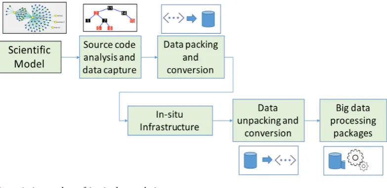
The data analysis framework developed in our study consists of four major components: 1) source code analysis and data capture; 2) data packing and con-version tools; 3) in-situ infrastructure; and 4) data analysis packages. The work-flow of the framework is illustrated in Figure 1. The main functions and objectives of each component are listed in the following sections.
2.1. Source Code Analysis and Data Capture
[image:2.595.143.535.525.715.2]In this step, we analyze the source code dependency using the information ex-tracted from compilers or language parsers. The main goal is to understand the software structure and to capture internal data structure and scientific workflow of the source code. For a given function or module of interest, we use program-ming language parsers to analyze the source code and store the program infor-mation as an abstract syntax tree (AST). Then, we conduct recursive name reso-lution through the AST to capture the input and output data streams of the tar-get function. Finally, we generate a code segment into the original source code to
DOI: 10.4236/jcc.2017.514007 78 Journal of Computer and Communications package all the data of interest into a continuous memory buffer ready for in-situ
data transfer. More detailed information on the source code analysis and data capture can be found in previous publications [9] [10].
2.2. Data Packing and Conversion Tool
As most scientific codes, Earth system models use highly customized data struc-tures. As mentioned in the previous section, the data is packed into a continuous memory block for efficient data transfer using the underlying in-situ infrastruc-ture. The internal information on the customized data structure has to be rec-orded as well, to reconstruct the customized data types after data transferring. It is also worth to mention that most in-situ infrastructures use specific data for-mations to facilitate its performance, therefore, it is convenient to create a soft-ware tool for the data conversions between applications and in-situ infrastructures.
2.3. Integration with In-Situ Infrastructure
By now, several in-situ infrastructure have emerged, including data analysis and visualization toolkits (such as ParaView [11] and VisIt [12]) and high perfor-mance data infrastructure (such as ADIOS and GLEAN). These infrastructures enable full capability of in-situ data processing at the benefit of large I/O cost savings and better utilization of all available resources. In our study we leverage the capabilities with the adaptive IO system developed at ORNL.
2.4. External Packages for Automated Data Analysis
There are several comprehensive packages widely used for big data analysis, in-cluding graph database and machine learning [13] [14] [15]. In this study, we use a free, python-based machine learning library (Scikit-learn) for automated data processing. Scikit-learn features various classification, regression and clus-tering algorithms including support vector machines, random forests, gradient boosting, k-means and DBSCAN, and is designed to interoperate with the other Python libraries.
3. Case Study: An In-Situ Data Analysis System for the
E3SM Land Model
Energy Exascale Earth System Model (E3SM) is a national effort to address the challenging and demanding climate-change research imperatives. Within the E3SM modeling framework, E3SM Land Model (ELM) is a process-based model that represents the energy-water-biogeochemistry interactions between the at-mosphere and the terrestrial landscape. We implement an in-situ data analysis system for the ELM and focus on key biogeophysical and biogeochemical func-tions.
DOI: 10.4236/jcc.2017.514007 79 Journal of Computer and Communications reaches a fairly large scale with a huge amount of data and daunting in-put/output cost. A previous pilot effort focused on demonstrating a concept and small-scale (pointwise) prototype [8]. Our current effort is to process global si-mulations with the integration of scalable in-situ infrastructure and advanced data processing package.
3.1. Computing Platform
The platform used in this study is a Linux cluster within the Computing and Data Environment for Science (CADES) at Oak Ridge National Laboratory. The cluster has 48 nodes of Cray CS400 machines. Each node contains 2 Intel E5-2698v3 16-core (total of 32 per node), 128 GB RAM, Dual port mellanox-FDR IB and 10GbE and 250 GB local hard drive. The cluster shares a Petascale parallel file system with other clusters within CADES. External users can access these ORNL HPC clusters via two dedicated login nodes.
3.2. Software System Implementation
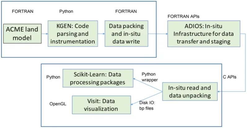
The ELM used in the study comes from the newest version of E3SM code in 2017. In the past, we have developed two methods for parsing and analyzing the ELM code based on KGEN and PGI Fortran compiler [9]. In this study, we fur-ther enhanced our code parsing and analysis capability using KGEN to better handle the global, nested and customized ELM data structure. Since KGEN is written in Python, we developed our own python script to extract information from KGEN and generate FORTRAN code segments into the ELM source code for data packing. The underlying in-situ infrastructure used in our study is the Adaptive IO system (ADIOS) [3]. We use ADIOS with the ELM code as an ex-ternal module. We developed a data writer that uses two different in-situ me-chanisms available in ADIOS, FlexPath and Data Spaces, depending on the cha-racteristics of specific ELM variables. On the data analysis side, we developed a data reader using the ADIOS C API and then converted it into a shared library with SWIG. This way we can access this staged reading function through other applications, such as python-based data analysis packages. In our study, Sci-kit-learn is used to handle the data streams from ELM simulations. Technically, we used the ADIOS reader in C to retrieve the data streams from ADIOS infra-structure, and converted the data into python arrays which can be integrated with Scikit-learn functions. We can also dump the data into disk using the native ADIOS data format and then connect to other applications, such as Visit, for further applications. The procedure and high-level implementation of our sys-tem is illustrated in Figure 2.
4. Analysis of Total Leaf Area Index within Global
Terrestrial Ecosystem Simulations
4.1. Simulation System Configuration
DOI: 10.4236/jcc.2017.514007 80 Journal of Computer and Communications
Figure 2. Software system implementation of the in-situ data analysis for earth system simulation.
The simulation starts at the spinup stage, driven by the climate datasets of 1920 - 1948, developed by the Climatic Research Unit in the United Kingdom. It also runs assuming a constant CO2 and land use in 1850. For the purpose of testing our approach, the spinup only runs for 320 years, long enough to dem-onstrate how plants evolve in warm regions such as the tropics, without in-situ
Data Analysis Tools plugged in. Then the simulation restarts from the end of the spinup run and continues for a transit run (1850 to 2010). The transit run is configured to simulate the historic Earth system behavior since the industrial revolution. It is one of commonly used simulation configurations for future sce-nario projections.
4.2. Total Leaf Area within Terrestrial Ecosystem Modeling
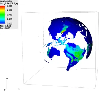
For the demonstration, we capture and analyze the values of Total Leaf Area In-dex (TLAI) through the half year global terrestrial ecosystem simulations and calculate the data characteristics (such as statistics and primary components) of TLAI during the real-time simulations using built-in function from Sci-Kit-Learn. Leaf area index (LAI), i.e. projected one-side foliage area over ground surface, is a dimensionless quantity that characterizes the vegetation foliage size and thus its function in the Earth system model to predict photosynthetic pri-mary production, evapotranspiration, and it can be regarded as an indicator for plant growth or greenness. As such, LAI plays an essential role in theoretical production ecology. In ELM, LAI is simulated for total 17 individual vegetation types in a grid cell. Then, with the consideration of the actual vegetation cover-age of each grid cell, these individual LAIs are fraction weighted to calculate total LAI (TLAI) at each grid cell on the land section of the Earth.4.3. A Snap Shot of TLAI Map at the Beginning of Simulation
DOI: 10.4236/jcc.2017.514007 81 Journal of Computer and Communications
Figure 3. A snapshot of simulation result: the map of TLAI values at the beginning of global simulations.
at the very beginning of simulation (12 am GWT, January 1, 1850). The TLAI at each grid around the globe (total 360 × 720 cells) is calculated as a weighted summarization of LAI on each vegetation type (called patch) times the percen-tage of vegetation area within each grid cell. Obviously, TLAI values of tropical cells, such as Amazon and other low altitude, well vegetated areas, are much higher than TLAI at other places. It is also noticeable from the TLAI map that the beginning simulation is a winter time at north hemisphere, since the TLAI is low at these middle-latitude areas in the north hemisphere.
4.4. Automated Global TLAI Clustering
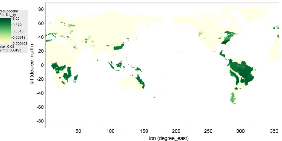
This test is designed to demonstrate the automated data processing using a ma-chine learning package, SciKit-learn. After the data of interest is extracted and transferred from the simulation, transferred data arrays are transformed into numpy arrays that can be accessed by a Python application. In our test, we use the built-in statistical functions of Scikit-learn to classify TLAI values during the simulation, so that the seasonal global vegetation greenness pattern can be rec-ognized dynamically. Figure 4 shows the automated clustering of TLAI values (into 9 group) at a single half-hour time-step during the simulation. The clus-tering was carried out by using k-means in Scikit-learn.
DOI: 10.4236/jcc.2017.514007 82 Journal of Computer and Communications
Figure 4. The spatial pattern of automated global classification of high-resolution TLAI at a single half-hour time-step during simulation. The classes are categorized by mean plus or minus fractional SD.
changes. Post data analysis, such as classification in Figure 4, allows for more clear spatial patterns (with less noise). This is very beneficial for modelers to understand and interpret results.
4.5. Performance Analysis
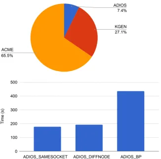
Two sets of experiments have been conducted to understand simulation perfor-mance. We first record the walltime used for data collection, packing and trans-fer. The pie chart of time division is illustrated in the left graph of Figure 5. We do not directly compare the original E3SM configuration with filesytem opera-tions since it is just too slow to be useful in practice. The walltime of E3SM shown in Figure 5 is used for computation only. Data transfer via ADIOS takes about 7.4%, while the data packing and convert via KGEN takes more than 25% of time. We will need to further investigate and improve the performance of data packing. In this study, we also investigate how to achieve best performance with different process placement strategies. The time of running E3SM on different configurations is illustrated in the right-side chart of Figure 5. The performance of the data transfer can be optimized by mapping each pair of ADIOS reader and writer on the same compute node, shown as ADIOS_SAMESOCKET, instead of on different nodes, shown as ADIOS_DIFFNODE. ADIOS_BP shows the time to write the data back into disk. Since we can save a lot of disk IO time using the
in-situ infrastructure, both ADIOS_SAMESOCKET and ADIOS_DIFFNODE are much faster than ADIOS_BP.
5. Conclusion and Suggestions
DOI: 10.4236/jcc.2017.514007 83 Journal of Computer and Communications
Figure 5. Performance analysis.
system simulation based on automated source code instrumentation, in-situ in-frastructure and real-time data processing. We have designed a case study of Earth system simulation to demonstrate the practical usefulness of the data analysis system and its computing performance. With the integration of external data processing package, such as Scikit-Learn, SPACK and TensorFlow, we can easily apply novel machine learning approaches to study simulation results in on the fly. We believe the in-situ processing is a feasible way to investigate large scale climate simulations without intensive human interaction and it avoids the prohibitive IO cost of post-processing on high performance computing plat-forms. Future efforts will have two directions. We will focus on tuning the per-formance on high end computers, such as Titan and Summit-Dev at the Nation-al Center for ComputationNation-al Science at Oak Ridge NationNation-al Laboratory. We will also work to integrate our data analysis system with other external packages, such as TensorFlow, for further large-scale Ecosystem simulation data analysis on hybrid architectures. Science efforts will focus on relationship identifications between the extreme weather events and long term ecosystem behaviors.
Acknowledgements
DOI: 10.4236/jcc.2017.514007 84 Journal of Computer and Communications Biological and Environmental Research program (E3SM and TES). This research used resources of the Oak Ridge Leadership Computing Facility at the Oak Ridge National Laboratory, which is supported by the Office of Science of the U.S. Department of Energy under Contract No. DE-AC05-00OR22725.
References
[1] Wang, D., Schuchart, J., Janjusic, T., Winkler, F., Xu, Y. and Kartsaklis, C. (2014) Toward Better Understanding of the Community Land Model within the Earth Sys-tem Modeling Framework. Procedia Computer Science, 29, 1515-1524.
https://doi.org/10.1016/j.procs.2014.05.137
[2] Wang, D., Xu, Y., Thornton, P., King, A., Steed, C., Gu, L. and Schuchart, J. (2014) A Functional Test Platform for the Community Land Model. Environmental Mod-elling & Software, 55, 25-31.https://doi.org/10.1016/j.envsoft.2014.01.015
[3] Liu, Q., Logan, J., Tian, Y., Abbasi, H., Podhorszki, N., Choi, J.Y., Klasky, S., Tchoua, R., Lofstead, J., Oldfield, R. and Parashar, M. (2014) Hello Adios: The Challenges and Lessons Of Developing Leadership Class I/O Frameworks. Concur-rency and Computation: Practice and Experience, 26, 1453-1473.
https://doi.org/10.1002/cpe.3125
[4] Vishwanath, V., Hereld, M. and Papka, M.E. (2011) Toward Simulation-Time Data Analysis and I/O Acceleration on Leadership-Class Systems. 2011 IEEE Symposium on Large Data Analysis and Visualization (LDAV), Providence, Rl, 23-24 October 2011, 9-14. https://doi.org/10.1109/LDAV.2011.6092178
[5] Russell, S.J. and Norvig, P. (2003) Artificial Intelligence: A Modern Approach. 111-114.
[6] Kress, J., Klasky, S., Podhorszki, N., Choi, J., Childs, H. and Pugmire, D. (2015) Loosely Coupled In Situ Visualization: A Perspective on Why It’s Here to Stay. Proceedings of the First Workshop on In Situ Infrastructures for Enabling Ex-treme-Scale Analysis and Visualization,Austin, TX, 15-20 November 2015, 1-6.
https://doi.org/10.1145/2828612.2828623
[7] Malakar, P., Vishwanath, V., Munson, T., Knight, C., Hereld, M., Leyffer, S. and Papka, M.E. (2015) Optimal Scheduling of In-Situ Analysis for Large-Scale Scientif-ic Simulations. 2015 SC-International Conference for High Performance Compu-ting, Networking, Storage and Analysis, Austin, TX, 15-20 November 2015, 1-11.
https://doi.org/10.1145/2807591.2807656
[8] Wang, D., Yuan, F., Hernandez, B., Pei, Y., Yao, C. and Steed, C. (2017) Virtual Observation System for Earth System Model: An Application to ACME Land Model Simulations. International Journal of Advanced Computer Science and Applica-tions, 8, 171-175.https://doi.org/10.14569/IJACSA.2017.080223
[9] Wang, D., Pei, Y., Hernandez, O., Wu, W., Yao, Z., Kim, Y., Wolfe, M. and Kitchen, R. (2017) Compiler Technologies for Understanding Legacy Scientific Code: A Case Study on an ACME Land Module. Procedia Computer Science, 108, 2418-2422.
https://doi.org/10.1016/j.procs.2017.05.264
[10] Wang, D., Wu, W., Janjusic, T., Xu, Y., Iversen, C., Thornton, P. and Krassovisk, M. (2015) Scientific Functional Testing Platform for Environmental Models: An Ap-plication to Community Land Model. 37th International Workshop on Software Engineering for High Performance Computing in Science.
DOI: 10.4236/jcc.2017.514007 85 Journal of Computer and Communications
https://doi.org/10.1016/B978-012387582-2/50038-1
[12] VISIT Team (2003) VISIT: Software the Delivers Parallel Interactive Visualization. Lawrence Livermore National Laboratory. http://visit.llnl.gov
[13] Zaharia, M., Xin, R.S., Wendell, P., Das, T., Armbrust, M., Dave, A., Meng, X., Ro-sen, J., Venkataraman, S., Franklin, M.J. and Ghodsi, A. (2016) Apache Spark: A Unified Engine for Big Data Processing. Communications of the ACM, 59, 56-65.
https://doi.org/10.1145/2934664
[14] Abadi, M., Barham, P., Chen, J., Chen, Z., Davis, A., Dean, J., Devin, M., Ghemawat, S., Irving, G., Isard, M. and Kudlur, M. (2016) TensorFlow: A System for Large-Scale Machine Learning. OSDI, 16, 265-283.