Studying a Changing Earth from a Generation Long Viewpoint
(Proposal for a HH/lSS Experiment)
Authors:
James H. Nicholson, CAN DO Project Principal Investigator - Medical University of South Carolina Thomas J. O'Brien, CAN DO Project Chief Engineer - Medical University of South Carolina
Carol A. Tempel, CAN DO Project Coordinator - Charleston County School District Kathy Rackley, EarthKAM Lead Teacher – Mason Preparatory School
Eve Katuna, EarthKAM Lead Teacher – Drayton Hall Middle School
BACKGROUND
At the 1992 Shuttle Small Payloads Symposium, the CAN DO Project described a Gas payload called GeoCam which was designed to obtain the first ever high resolution images of the Earth taken by an educational experiment. The project team, in consultation with the National Geographic Society, had specifically designed the camera system to exactly match the optical and spectral characteristics of the NASA Skylab EREP (Earth Resource Experiment Package) camera system. The goal was to produce images that could be directly compared to the Skylab images taken two decades before. The Skylab EREP produced the first comprehensive and systematic image survey of the earth from space. These 36,000 high-resolution multispectral images represent a priceless treasure as one of the earliest possible baselines from which to evaluate the environmental changes undergone by our beleaguered planet.
The GeoCam payload (G324) did fly on STS-57 in June 1993 and produced spectacular high quality images of the Earth. The cameras were controlled by the orbiter crew based on instructions
received from the first ever student operated mission control room. The GeoCam project received national attention and was the subject of a nineteen-page article in the August, 1994 National Geographic Magazine.
GeoCam has to be considered a great success. Unfortunately, not a single target was obtained that matched a Skylab EREP target area. This was a result of several factors including a 28.5o orbital inclination as opposed to Skylab’s 50o inclination, and a change in launch dates which put the Western Hemisphere (where most EREP targets are located) in darkness. More to the point, it clearly demonstrated that the space shuttle is not a suitable platform for highly specific targeting. The short mission duration does not allow for the required confluence of exact orbital track, sun angle, shuttle orientation, and clear weather. The International Space Station, on the other hand, is a perfect platform with an orbital inclination nearly identical to Skylab and the long timeline necessary to systematically duplicate the EREP images. The concept is as valid today as it was in 1992, but now there is a real opportunity to produce images of great educational and scientific value. The EREP images are now over a
quarter of a century old, and differences will be all the more observable, and important. They can serve as a means to better understand and measure environmental degradation. The long baseline will more clearly separate long term changes from transient or short-term cyclical events. Historical examinations of change often look far back into Earth's history to determine the rate and degree of natural changes. The rapid growth of human population presents fundamentally different pressures on the Earth's ecosystem. To gain new insight on
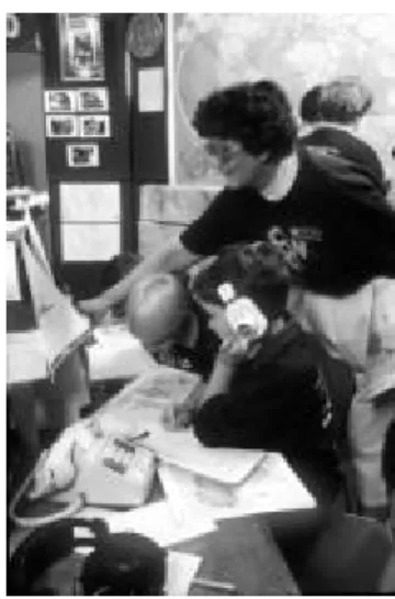
Figure 1. GeoCam POCC (1993)
human-induced changes, earth scientists focus on the changes that have occurred over a shorter time span (25 years). During this time, natural and human induced changes on the surface of the earth have been photographed from space. Comparison between photos past and present enables documentation of profound changes to the Earth. One of the largest early data sets of earth observing photographs comes from the Skylab archives. These photographs covered much of the Earth's surface, and are an important baseline with which to compare present and future photographs. It is the major goal of the GeoCam II project to provide a direct link to this resource.
The Skylab Legacy
One human generation (25 years) has passed since the United States' ambitious Skylab program. A major component of those missions was the acquisition of earth photography using a six camera, multispectral camera system. The first multispectral photography done from space was on the 1968 Apollo 9 mission. Four mounted Hasselblad cameras were aimed at the same target point and their shutters triggered simultaneously. A significant advance in Earth imaging technology resulted from subdividing spectral ranges of radiation into bands (intervals of continuous wavelengths), allowing acquisition of multispectral images. Especially important was the addition of infrared bands. Black and white infrared film was developed in Germany in the early 1900’s. The film emulsion differed from regular film in that it was sensitive to wavelengths of energy longer than red light and just beyond the range of the human eye. By 1930, black and white IR (infrared) films were being used for landform studies, and from 1930 to 1932 the National Geographic Society sponsored a series of IR photographs taken from hot air balloons. The infrared bands are often used to emphasize healthy vegetation in which light in the range of 700 -1100 nm is strongly reflected from the internal cells of plants. A false color composite can demonstrate stressed or unhealthy vegetation and more clearly differentiate barren areas. The use of false color infrared imaging can be especially useful for monitoring change such as the deforestation of rain forests. The value of multispectral photography was not lost on scientists, such as geologists, hydrologists, agronomists, foresters, and those concerned with environmental monitoring and land use assessment. It quickly became a major scientific tool. The success of this experiment lead directly to the Skylab system as well
as the Landsat series of satellites. By the late 1960s, the first unmanned satellite specifically dedicated to multispectral remote sensing entered the planning stages that led to the launch of ERTS-1 (Earth Resources Technology Satellite) in 1972. Renamed Landsat, this series of earth-observing satellites has continuously covered most of the Earth's surface since then, with Landsat-5 and Landsat-7 currently in operation.
Three separate crews worked on Skylab in 1973-74 and participated in the Earth photography experiments. The purpose of the Earth Resource Experiment Package (EREP) was to determine what kind, and how much, photographic data could be acquired of the broad variety of Earth features witnessed on the mission's ground track. This activity was underwritten by intensive training before lift-off, real-time scientific mission planning and on-board procedural support. This focus elevated Earth Imaging from an opportunistic sideline to a major mission goal.
The Skylab spacecraft was launched on May 14, 1973 into a nearly circular orbit at an altitude of 435 km above the Earth. The launch azimuth
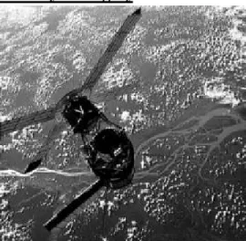
inclined the orbital plane 50o with respect to the Equator and allowed observations of the Earth between latitudes 50oN and 50oS. It orbited the Earth every 93 minutes and repeated the ground track every five days. Figure 2. Skylab over the Amazon
Figure 3. Skylab EREP image of southern Louisiana
The photographic return from the Earth Resources Experiment Package (EREP) was as follows:
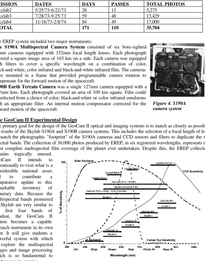
MISSION DATES DAYS PASSES TOTAL PHOTOS
Skylab2 5/25/73-6/22/73 28 13 5,275
Skylab3 7/28/73-9/25/73 59 48 13,429
Skylab4 11/16/73-2/8/74 84 49 17,000
TOTAL 171 110 35,704
The EREP system included two major instruments:
The S190A Multispectral Camera System consisted of six bore-sighted 70mm cameras equipped with 152mm focal length lenses. Each photograph covered a square image area of 163 km on a side. Each camera was equipped with filters to cover a specific wavelength on a combination of color, black-and-white, color infrared and black-and-white infrared film. The cameras were mounted in a frame that provided programmable camera rotation to compensate for the forward motion of the spacecraft.
S190B Earth Terrain Camera was a single 127mm camera equipped with a 457mm lens. Each photograph covered an area of 109 km square. Film could be selected from a choice of color, black-and-white or color infrared emulsions with an appropriate filter. An internal motion compensator corrected for the forward motion of the spacecraft.
The GeoCam II Experimental Design
The primary goal for the design of the GeoCam II optical and imaging systems is to match as closely as possible the results of the Skylab S190A and S190B camera systems. This includes the selection of a focal length of lens to match the photographic "footprint" of the S190A cameras and CCD sensors and filters to duplicate the six spectral bands. The collection of 36,000 photos produced by EREP, in six registered wavelengths, represents the most complete multispectral film coverage of the planet ever undertaken. Despite this, the EREP collection remains tragically unused.
GeoCam II intends to operationally re-visit what is a considerable national asset, and to contribute a comparative update to this remarkable inventory of planetary data. Because the multispectral bands pioneered on Skylab are very similar to the first four bands of Landsat, the GeoCam II system becomes a capable research instrument in its own right. It will give students a powerful system with which to explore the multispectral images and image processing which is so fundamental to modern remote sensing. The recent proliferation of relatively inexpensive high resolution CCD chips with
Figure 4. S190A camera system
color, monochrome and infrared capability makes it possible to design an affordable camera system which will exactly duplicate the optical and spectral properties of the six-camera S190A Skylab multispectral camera system. The high sensitivity of silicon in the infrared means that a CCD-based camera can make an excellent sensor for the near infrared wavelength range of 750 nm to 1000 nm which present a difficult problem for film. Six separate digital sensors will simultaneously capture an image, which will then be downloaded to a central processor using an IEEE 1394 high-speed interface. The inherently small size of the CCDs will allow the lens/camera systems to utilize relatively small optical windows. The use of dichoric beam splitters could reduce the size even more by allowing for multiple wavelengths to be captured through a single lens system. Such a system could be built now with off-the shelf equipment, and the rapid development of the digital image field will allow better performance at an even lower cost in the near future. High-speed architecture and mass storage media will be required to handle the large amount of data produced and to store it pending downlink opportunities. Each multispectral image set will produce between 6MB (1k x 1k at 8bit grayscale) and 32MB (2K x 2K at 12 bits grayscale) of data. Image compression may be used to reduce the data load, but it is well within the reach of current system capabilities. The KidSat and EarthKAM programs have demonstrated the practicality of downloading large digital image files. The control interface could be modeled on NASA's EarthKAM project, which provides a working structure for using high-resolution digital Earth images in education. The multispectral system can serve as a natural extension of the EarthKAM program by allowing the students to conduct a more advanced research project through the comparative study of twenty-five years of environmental change. Access to true multispectral images will allow for a richer learning experience and a chance to explore imagery as a quantitative scientific tool rather than just for color documentation of geographic morphometry.
Payload Design
This concept payload study assumes the use of standard Hitchhiker/GAS hardware and specifications whenever possible. The Hitchhiker canister, with its avionics and adapter ring, possibly mounted on a JEM-EF (Japanese Experiment Module - Exposed Facility) or EXPRESS pallet with an attachment interface for the ISS could conceivably mount at either the JEM, S3 or P3 PAS (Payload Attach System) mounting sites.
The camera system itself is built around a Hitchhiker/GAS five cubic foot canister mated to a motorized door assembly, which is fitted with a fused silica window. Construction is based on four circular plates separated and supported by three equally spaced struts attached on the circumference. The cameras will be mounted behind the first, a 16mm (5/8") 6061-T6 aluminum plate that acts as a containment shield and structural stabilizer, fitted with a thin glass epoxy light baffle to reduce reflected glare in the optical system.
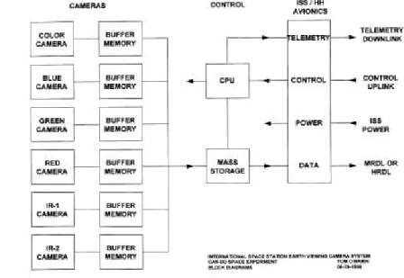
Six digital cameras operating in different portions of the light spectrum from ultraviolet to infrared are aligned and mounted on the second plate located near the containment shield. Below the camera mounting plate is the third of four internal plates. This plate supports the camera electronics and any ancillary electronics packages needed to interface with the ISS Hitchhiker avionics package. Below this is the fourth or bottom structural plate, which provides support and rigidity through the three base bumpers that provide a mechanical interface with the flight hardware.
Each camera optical path is chosen to match its Skylab equivalent in both spectral range and subject footprint size as closely as practical. With improvements in exposure speed allowed by advances in digital technology, the payload will be able to do away with the cumbersome mechanical rotating mechanism used to stabilize the Skylab camera platform, which was necessary to compensate for orbital motion and extended film exposure times. All six cameras will be fired simultaneously, and the pictures transferred to each camera’s four picture buffer memory. The picture data files will then be sequentially transferred to a mass storage unit which will compress and warehouse the data until it can be downloaded through either the ISS MRDL (Medium Rate Data Link) or the HRDL (High Rate Data Link) as may be available. Camera control will be uplinked through the Hitchhiker control uplink, which is at present an RS-422 serial format (1200 baud) channel. While in operation, the computer will continually monitor all cameras, electronics, payload environment, and its own health, and return the system status by way of the Hitchhiker downlink, which also runs at 1200 baud. Operational power will be derived from the ISS through the Hitchhiker avionics package, and further regulated for the payload requirements.
THE VIEW FROM SPACE
Photographic analyses of land use practices give insight into changes. Linear functions can be used to project the rate of future change. As growing human population requires an ever-increasing share of the Earth's surface on which to live, human activities change the distribution of plants and animals, alter drainage patterns, and modify natural boundaries. In doing so, mankind changes either the reflective or emissive properties of the surface. Such changes are detectable from space. Human actions that change the reflectance
or color of the Earth's surface can be recorded with space photography. Activities include:
q DEFORESTATION. Forests are optically dense, green areas. The cutting of the trees produces a more reflective surface and exposes a different color. Deforestation scars are seen in the rain forests throughout the world. Forests are often cleared by setting fire to the vegetation, and smoke from these fires is visible from space.
q URBANIZATION. Urban areas are delineated by highly reflective paved surfaces. Because the growth of cities is at the expense of vegetated surfaces, the increase in reflectivity can be measured.
q FLUVIAL SEDIMENT LOADS. Clear cut forestry practices in many tropical countries have altered the sedimentary load of the rivers that drain the forest. Rivers loaded with sediment have a different color than "clean" rivers that drain forested areas. Sediment laden rivers, such as the Betsiboka River of Madagascar, are now red-brown when seen from space.
q DESERTIFICATION. The reflective surface of deserts and eolian sediment patterns are also visible from space. The encroachment of deserts over once vegetated surfaces will register a shift in the optical and textural character.
q COASTAL EROSION. Analysis of the position of the coastal features can be used to determine the rate and location of large-scale coastal changes. Dramatic rates of erosion can be seen on the edge of the Nile and Ganges river deltas.
q LAKE LEVELS. Changes in boundary relations can detect variation in water levels in lakes (e. g., Lake Chad) or inland seas (e.g., Aral Sea).
q WETLANDS. The delineation of wetlands is sometimes difficult. Changes in vegetation color and the sea land boundary are sometimes needed to detect loss.
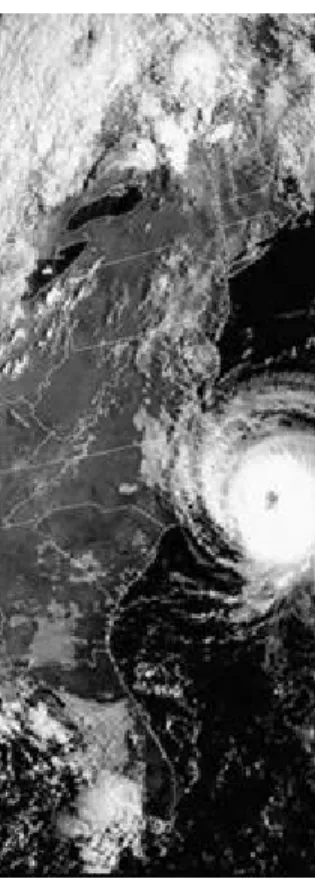
Figure 8. East Coast Hurricane
EARTH OBSERVATION AND EDUCATION
Image comparisons are powerful teaching tools, particularly to show change over time. By comparing transformation that has been documented in remote images, changes that have occurred in our lifetimes can be observed. It is hoped that such documentation of global change will make this issue more immediate and real. There is an additional benefit in the lessons that they teach us.
According to Charles F. Kennel, Associate Administrator for Mission to Planet Earth, “The ultimate product of Mission to Planet Earth is education it its broadest form. Our vision is a sustainable Earth system science education program rooted in strong principles and objectives. NASA's Mission to Planet Earth (MTPE) Enterprise provides long-term studies of the Earth system needed to answer critical questions about how the global environment will affect us now and in the future. The unique vantage point of space provides the global perspective needed to better understand how all of the parts of the Earth's environment- air, water, land, and life-interact and make life possible.”
NASA has defined specific objectives for its Earth Science Enterprise Education Program. The first are to:
q Train the next generation of scientists to use an interdisciplinary Earth system science approach
q Continue to educate and train educators as research evolves and capabilities change
An important goal of the CAN DO GeoCam II mission is to provide a vehicle for stimulating hands-on experiences for students so that they can better interpret the global environmental changes that will determine the quality of the world that they will inherit. Specific program goals include:
q Provide an educational vehicle to support serious student research in environmental change
q Provide training to teachers and students in the use of multispectral imaging and digital image processing
q Provide high quality matched images to evaluate geomorphologic change over time
q Provide students the opportunity to interact with ISS and leading scientists while conducting real-life research of their own design and under their control.
q Provide a vehicle to support advanced technology skill training of teachers
GeoCam II Educational Design
Charleston Can Do teachers and students have consistently demonstrated the use of cutting edge technology in teacher education, student projects, and teacher/student presentations at regional, national, and international conferences. Throughout the GeoCam, KidSat, and EarthKAM projects, NASA has drawn on Charleston educators for leadership roles in all of these projects.
The GeoCam project was the creative development of the Charleston County School District Can Do Project supported by its education partnerships with the Medical University of South
Carolina and the College of Charleston. There were many lessons learned from that project and later expanded in the NASA sponsored KidSat and EarthKAM projects. GeoCam II will apply these experiences and build on them. Charleston Can Do teachers have benefited from their ongoing involvement in every one of these missions.
GeoCam developed the concept of a student-run mission control room. This idea evolved and grew more as the teachers and students built a team approach. The central idea that GeoCam promoted was that students would be running the mission operations center using sophisticated (pre-Internet) technology and teachers would support them as advisors and mentors. The idea that students in middle and high school would be running an active control room interacting with the Shuttle crew was an original and innovative idea in educational methodology. Learning to work cohesively with students from other schools and regions was another challenge to overcome.
Developing job descriptions for the various positions and training students in the job assignments solved the problem. Variations on this model have been used for all student mission control rooms that followed. Major technology changes, especially the development of the Internet, have changed the operational patterns
and allowed for the near real-time delivery of the images. The primary personnel functions have remained constant. The decision to have a central student mission control room with students from participating schools
Figure 9. Student teacher team
assuming specific responsibilities for a specified shift was one of the early innovations. The specialist positions have been adapted at every subsequent student mission control room. This model allowed for more than 180 students to be active in the mission control room over a period of eight days in groups of 20 to 30. Parents and teachers have been both surprised and pleased by the level of activity and the good order in which students have been able to perform useful targeting in a limited amount of time. It was found that advanced teacher education and practice mission simulations were essential to build the confidence of everyone and test the model before the mission. This process is now part of all student mission control rooms. Teachers and students shared input about how to improve the control room and changes were made as needed. Many students wrote in journals about the positive feelings from the mission control room. A student from Buist Academy wrote that this was real and whatever target was selected was their own responsibility. Students felt very empowered and as a consequence, carefully prepared for and thoughtfully executed their mission responsibilities. In this atmosphere, students often performed at levels beyond their teachers’, their parents’, and even their own expectations. They left the experience with not only new skills but with a vastly improved self-confidence and self image.
The NASA KidSat project selected Can Do teachers to participate as lead teachers to both write and pilot the project for three years. The idea of individual mission control rooms using the latest computer technology, the new Internet in 1994, was tried in schools. The push to get schools connected to the Internet (almost all were not) was considered innovative at the time. These schools were on the leading edge of image technology use in the classroom. Some schools liked the control they had over the image selection and the event atmosphere that an active mission created in the whole school. But in other schools, because not all students in a school were involved in the project, some teachers and principals found it disruptive. KidSat demonstrated a need to develop a model that fits the school district technology resources and individual principals' comfort zones. As a result, the follow-up EarthKAM project has been experimenting with a consolidated regional control room. GeoCam II suggests a flexible model that will use a central control room and partner schools working together. Individual schools that wish to have a control room site could use the Internet to send requests to the regional control center. This multi-layered model will allow schools and district to choose the form of participation that best meets their individual needs.
The most educationally important outcome has been the use of Earth image technology by students to try to answer science related questions. Lessons were developed from the original GeoCam images that became the models for future lessons in the KidSat and EarthKAM projects. Lessons were developed by Charleston County educators to teach other teachers and students how to relate images, maps, and science questions. As an example, students in the first KidSat project used images to study the Rio Xingu, a river in Brazil. These student-scientists used the 1996 KidSat mission images, 1976 maps, and computer technology to demonstrate river changes. Teachers and students presented these findings at national and international conferences. Other project included exploration of small islands in the Pacific Ocean, changes in the size of the Dead Sea, exploration of coastal changes, and many other examples. Teachers have taught students to look beyond their books and library. They have presented an opportunity for students to take personal interest in areas of science that they choose to explore and to teach them to use new tools to achieve their personal research goals. The role of education in the GeoCam II project is one that will be felt in classes across the country. The placing of the GeoCam II cameras on the International Space Station will offer the chance for multispectral images to be selected and used by students in every classroom. The GeoCam II project will continue to offer students the opportunity to participate in science in a very real way while still having fun.
Geomorphology and the Analysis of Change
Over a span of time, there is a dramatic change in the geomorphology of the earth’s surface. When viewed from above, it is very clear that the Earth’s surface has changed dynamically because of natural forces and because of man’s intervention into natural geologic processes.
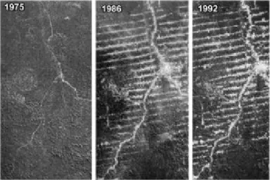
Image comparison over a significant span of time will allow teacher and student to view the environmental impact that man has had on an area. The deforestation of the Amazon rainforest and the on-going change in the course of the sediment-laden streams are clearly defined through image comparison. Deforestation involves the cutting down, burning and damaging of forests. Most of the clearing is for agricultural purposes and commercial logging. The world’s population has increased causing a real need for survival. However, at what cost? Students will be able to compare the change in the landscape through time and research the reasons why the deforestation occurred and its profound effects on global climate and the possible loss of unidentified species. A brainstorming for solutions to this and other problems will allow students to problem solve and realize that their environment is influenced by the decisions made by others. Students will have the capability to do an in-depth image comparison over time and enter activities like the NASA Student Involvement Program.
Students might choose to hypothesize as to what effect the burning and clearing technique has on the topsoil. Rainwater carries away the topsoil, which goes into the river system. The turbidity or clarity of river water is an indicator of the amount of sediment that is being transported. If too much sediment is transported and the velocity of the river decreases the sediment is deposited in lobes. These will cause the river to change its’ course and become braided. This is evident in satellite imagery. The change in the color of the vegetation and the addition of sediment to the rivers will be evident in images taken by Skylab and by the GeoCam II cameras. A decline in vegetation and an increase in sediment load of rivers clearly points to a future environmental or agricultural problem.
Rivers, deltas, and other natural fluvial and coastal systems change through time. The formation of oxbow lakes, a changing flood plain, the development or erosion of a beach or offshore island could be investigated with a sequence of images that span several years. The tremendous diversity of fluvial systems and its relationship to the accompanying geology of the area on a global scale could be investigated by collaborative groups of students. Projects involving images taken by a camera onboard the space shuttle have engaged the students into comparisons and annotations of images from different geographic areas.
Students might choose to study the development of urban area and the transportation patterns (highways, roads and airports). This will be another feature that will be evident when images of the same area are reviewed over a span of time. The positive or negative impact of urban planning will clearly show up in images. The students’ understanding and willingness to investigate a problem of their choice has lead in the past to the development of excellent student projects. For example, students have compared London to Charleston. These projects serve as models as they represent excellence. Students do not limit themselves when given the freedom to expound. Presentations in my classroom, though scientific in nature, are sometimes presented in different methods such as prose. Students are given the opportunity to explore and present in a manner of their choice.
A dramatic change in the geology of an area will prompt students to investigate the cause. The dramatic impact that a volcanic eruption has on the landscape will be best observed by a sequence of images taken over time. It will allow the teacher and students to view the total impact of the volcanic eruption on the landscape and to investigate how the environment recovers from such an event. To evaluate a change requires images of the same area over a span of time. The color images which will be taken by the GeoCam II cameras onboard the International Space Station, covering163km per side, will be ideal for this type of study. The first step will be to
identify those factors that have changed after matching up the latitude and longitude of the area. The students will be able to speculate as to what forces (wind, volcanic, influence of water) caused the changes that they see. They will be able to identify the type of change, cite evidence as taken from the images and speculate as to the cause or causes of the change. This should lead them into an in-depth study as they investigate and even hypothesize as to what will happen to this particular geological area in the future if factors remain the same. Can Do teachers have involved their students in short-range research projects in the past. These were an effective learning tool. If students were able to evaluate and to actually see the geomorphic changes that areas undergo over time, they will engage in active learning and problem solving. This will provide them with a visualization of the changing face of the Earth through time.
Technology Skills
One of the most valuable aspects of the KidSat and EarthKAM programs has been the effective way in which they allow teachers and students to utilize technology skills in an educational setting. Instruction on the use of the Internet and digital cameras serves as a useful method to teach fundamental technology skills. Previous participants have acquired the skills to qualitatively identify, annotate
and interpret natural color images of the Earth from space. The KidSat and EarthKAM programs have only used natural color (red, green, blue) images while the GeoCam mission did take a single infrared band as well. Unfortunately, camera orientation limited the usefulness of the GeoCam photographic infrared images. So far multispectral, infrared and false color imagery has not been fully utilized in an educational setting. Its use will make information gathered by remote sensing a more valuable tool that will enhance and enrich the Earth Science curriculum. The GeoCam II multispectral approach will serve as an ideal instrument to address this need since the selection of spectral bands and digital image processing lie at the very heart of the technique. The inclusion of a separate natural color CCD will provide a
more familiar image to users who are not yet advanced enough to take full advantage of the system’s capability. These separate true color images will also provide useful reference and catalog images. They will be suitable images to compare to previous KidSat and EarthKAM images which share a similar scale. They will also be useful for comparison to the huge pre-existing library of Space Shuttle handheld pictures that are taken on every flight.
Team Building
To construct such an ambitious undertaking will require a team of educators and scientists coupled with the active support of NASA, equipment manufacturers and institutions such as the National Geographic Society. Successful projects like GeoCam, KidSat, EarthKAM and the Jason Project have developed the model for this type of teamwork. The International Space Station will provide a new vehicle for such a joint effort to produce a scientific and educational tool of real and lasting value. Since the watershed pictures taken by Apollo 8 showed us a small blue planet hanging in a black void, we have realized just how truly majestic
yet fragile our only home is. It is our generation’s responsibility to teach the next generation to appreciate and better understand the many diverse but also interdependent systems that exist on this planet we call Earth. It is just this appreciation of our fragile planet and the interdependence of one environment on another that may prove to be the key to our survival as a species.
Figure 12. Technology skills for educators
Figure 13. The 1992 GeoCam team representing the astronauts, four NASA centers, the National Geographic Society and the Can Do Project.
Relevant Publications
Nicholson JH: Students With a Mission, NASA Puts the Can Do Project in Orbit. National Geographic Magazine Vol. 186, No.2:54-69, August 1994
Nicholson JH, O’Brien TJ, Colgan M, Truluck RA, Frysinger J, Tempel CA: Earth Observation Photography, Looking Back 20 Years After Skylab. 1992 Shuttle Small Payload Symposium, NASA Conference Publication 3171:54-56, 1992
NASA -JSC: Skylab EREP Investigation Summary, NASA SP-399, prepared by NASA Lyndon B. Johnson Space Center, Washington D.C., 1978