785
Abstract: Accidents owing to potholes has become an alarming problem in today‘s life. The first step to solve this problem requires, designing a device
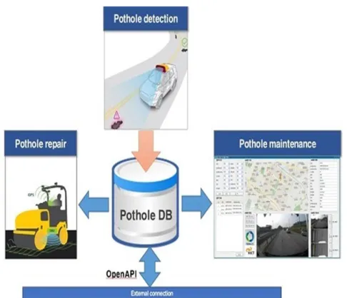
embedded on the vehicle which can continuously scan the road surface for identifying potholes, alerting the driver in time and enable the driver to avoid the pothole. The second step is to introduce a technique to enable the device to locate the position of the pothole via GPS (Global Positioning System). The GPS data can be uploaded via a GPRS (General Packet Radio Service) module or Bluetooth module onto a data base which is stored locally. This database can then be transferred to the cloud using WiFi or 4G technology by connecting the system. The third aspect is to link the database to a network system incorporating mapping software such as Google Maps or Open-Street Map. The data in the system can be made available to the general public as well as municipalities and road maintenance agencies. Awareness of the location of potholes will help drivers to avoid those roads and being more careful while driving on the same roads. This paper focuses on the pothole detection task based on image processing algorithms and the data captured from ultrasonic sensor placed on the vehicle. The later steps were implemented through Bluetooth interface available in smartphones.
Index Terms: Bluetooth communication, GPS, Image Processing, IoT, Real time pothole detection, Sensors, Smartphones, WiFi.
—————————— ——————————
1.
INTRODUCTION
Number of vehicle on the roads has increased enormously in the last decade. India being a developing country, construction and development of infrastructure is still in progress. This ever growing number of vehicles combined with the lack of infrastructure makes the road difficult to drive upon eventually leading to accidents. According to the road accidents in India 2017 report [1] of Ministry of Road Transport and Highways (MORTH), the number of accidents that occurred in 2017 alone due to the potholes is a staggering 9423 accidents which led to the death of 3597 and injuries to 8792 people only in India. This number takes care of only the reported case and if the unreported cases are also considered then the same number may go up to tens of thousands which is an alarming factor. Above stated factors enabled the need of designing intelligent vehicles which is able to detect potholes and humps on road]. Identification of pavement distress such as potholes and humps not only helps drivers to avoid accidents or vehicle damages, but also helps authorities to maintain roads. Several methods to detect humps and potholes are reported in published literatures. [2-5] Authors have done mentioned four major detection techniques namely vibration based, image processing based, 3 D image reconstruction based and vision based. [6-8] Author proposes use of kinect sensor and smart phone sensor for the detection of potholes. [9] Illustrates implication of SVM classification technique for pothole detection. [10-12]Explain different techniques for detection of potholes and generating an early warning for driver. [13-15] Authors have illustrated methodologies to maintain pavement‘s health data for longer period of time which can later be used for analysis and improvement of road infrastructure by the government authorities. This paper proposes a pothole detection system which aims at prior warning to the drivers about the uneven roads and potholes on the way. This information gets updated in cloud immediately which can also
be used by municipality and road maintenance agencies for immediate maintenance or repairing of potholes.
Designing of the prototype model involved different electronic components. Those are explained below-
A. Required Components
Processing unit The IoT based real time pothole detection system will give prior indication to the driver and store the location of the potholes. This is accomplished using microcontroller. Sensors The microcontroller is interfaced with the ultrasonic sensor, LED (for warning) and the Bluetooth module (for sending the GPS location of the pothole to the database). The proposed system is compatible with both Arduino and Wiznet board. Wireless communication Module The Bluetooth module is used to share the GPS location of the pothole. Bluetooth module is used instead of GPS module to make it cost efficient as GPS module is thrice the price of a Bluetooth module. The microcontroller is also interfaced with a WiFi esp8266 module which is used to send the data from the database to the cloud. The cloud storage can be done either in a private domain or a dedicated server may be used to store the same.
B. Application
Detect the potholes using image processing and alert the driver through the blinking of a LED
Store the GPS information about the detected potholes in the local database using Bluetooth
Send the database to the cloud and share with the common public so that municipality agencies or related government bodies can track and repair the same
It can be used by other vehicles also if we can link the database to mapping software such as Google Maps or Open Street Map
_______________
Chandra Mukherjee is working as an Assistant Professor in the Department of ECE, CHRIST (Deemed to be University
E-mail: [email protected]
Sushanth.G is working as an Assistant Professor in the Department of ECE, CHRIST (Deemed to be University
Fig 1: Overall Block diagram of Pothole detection system
2
METHODOLOGY
The methods followed in this work are as explained below:
1. The system comprises of a camera which can take snapshots in real time and send the captured images to MATLAB which is stored in a remote server using Wi-Fi or 4G/5G. There are 2 ways in which the pothole will be detected:
Photos of the road will be captured using a camera. These will undergo image processing using MATLAB, where the detection and verification of the presence of pothole will be done. If pothole is present, the driver will be notified /warned with the blinking of LED.
Fig 2: Overall flowchart of the process
Use of ultrasonic sensor will be the other way to detect the pothole. This method is shown in Fig2. The ultrasonic sensor will detect the irregularity in the road, and after confirming that it is a pothole, will send an alarm to the driver through the blinking of a LED. 2. Once the pothole is detected, its location will be stored in
the database locally. GPS coordinates of the pothole will be obtained from the driver‘s phone (which will be interfaced with the sensor using a Bluetooth module. 3. These coordinates will then be updated to the server
which will have a an entire database of potholes. This information can be used by the municipal organization or government agencies to repair the same.
4. The database will store the location of the potholes detected on the way. This collected data can be used for various applications.
5. The database stores the location of the potholes detected on the way and alerts the other driver travelling on same the way i.e it will be shown in GPS. This information can also be used by municipality people for immediate maintenance or repairing
3 EXPERIMENTAL
SETUP
AND
RESULTS
This work is implemented using two different approaches. the details of that approaches are explained below in detail
A. Pothole detection using MATLAB image processing A camera is mounted in the vehicle which captures the images. The image captured in real time is sent to a MATLAB code which is running on a remote server through Wi-Fi or 4G/5G. In MATLAB, the received image is converted to its binary form. Then a database of different images considering the depth and width of the Pothole is made and stored in binary form. If the binary value of captured image match with the binary values of the images stored in the database, then it is concluded as a pothole and after this, a notification in the form of an alert message will be provided to the driver by blinking of a LED
787
Fig 3: Original image considered for detection of Pothole
Fig 4: Gradient Magnitude computation of original image
Fig 3 shows the original image considered for pothole detection. This image is then taken to MATLAB and the gradient magnitude of the image is computed which is as shown in Fig4. In MATLAB, the function imgradient() returns the gradient magnitude of an image. This is then further processed to compute the regional maxima. The function imregionalmax() returns this regional maximum values of an image and this requires the greyscale component of the original image. Fig 5 shows the regional maxima computed for the image shown in fig 3.
Fig 5: Computation of Regional Maxima
The image of which regional maxima is computed is then processed further by opening by morphological reconstruction. This processing method involves processing an image according to the arrangement element where the image is contracted by deleting the objects which are smaller than the required shape. In opening by reconstruction, the image contracting is then followed by an image expansion where the image then regrows the objects which are left out after deletion of the other objects to the same shape as required. This processed image is as shown below in Fig 6.
Fig 6: Threshold detection for pothole identification
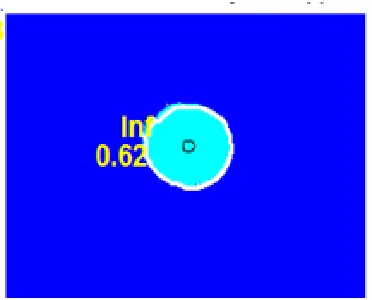
Fig 7: Pothole identification by considering shape and dimension
This work proposes an image processing based pothole identification mechanism by considering the shape and dimension of holes present in captured image. The algorithm firsts assigns a fixed threshold for segmenting captured images into two class namely- a. portion with potential pothole‘s presence b. non defective portion. Next probable pothole sections are exploited and experimented with different geometrical approximation techniques to extract the geometrical property of the region. This algorithm takes dimension and shape into consideration for detecting the pothole. This algorithm is implemented through MATLAB image processing toolbox and images were acquired from the camera fixed on the front side of the vehicle. Fig. 7 shows the identified pothole using proposed algorithm.
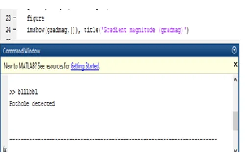
Fig 8: Pothole identification message on MATLAB screen
Fig 8 presents the screenshot of MATLAB screen demonstrating the output of above mentioned image processing algorithm. Developed algorithm incorporates driver notifying and alerting system as well. It notifies the driver through audio and visual message in order to avoid accidents due to pothole.
B. Hardware setup for pothole detection
This research work demonstrates real time implementation of image processing based pothole detection algorithm through a simple and low cost hardware setup. Hardware setup included ultrasonic sensor, camera, GPS module, Bluetooth module, camera and Arduino microcontroller board. A digital camera is fixed at the front side of the vehicle which captures image in real time and sends to Arduino microcontroller for further processing through Bluetooth module. The hardware setup has two parts namely- i. Sensor ii. Controller Unit. Sensing unit has camera and ultrasonic sensors fixed on front side of the vehicle to acquire inputs required for identification of pothole. Ultrasonic sensors send pulsed ultrasonic waves of a certain frequency and determine the objects distance from the duration of the ultrasound that it reflects. This sensor consists of a transmitter and a receiver unit. Depending on the distance we can identify the potholes and humps on the road. The distance should be more for potholes and less for humps compared to the normal distance between the road and the sensor. The sensor can be interfaced with Arduino or Wiznet board. Images captured by the camera are acquired using Arduino and is sent to MATLAB using serial communication for detection of potholes using image processing. A smart phone application is also made along with the hardware design which fetches the exact location of the potholes from GPS unit and updates to cloud server.
Fig 9: Experimental setup using Ultrasonic sensor
Fig 9: Hardware setup
5 CONCLUSION
The proposed system basically serves two purposes, one it is able to identify the potholes and humps on the road and sends the information regarding this to the vehicle drivers. This will help to avoid accidents and will save valuable lives. Second, the location of the pothole is saved in the database. This is an effective solution for detection of humps and potholes. This system is effective even in rainy season when roads are flooded with rain-water as well as in winter during low visibility, as the alerts are sent from the stored information in the server/database and helps us to avoid dreadful potholes and humps and hence to avoid any tragic accidents due to bad road conditions. The information can also be used by the Government authorities for the maintenance of the roads. The proposed system will give a voice alerts such as ‗Bad road ahead‘ along with led blinking in order to help the driver be more alert while driving/riding on such roads. The database could be linked to a network system incorporating mapping software such as Google Maps or Open-Street-Map in future.
REFERENCES
[1] Ministry of Road Transport and Highways, Government of India, ―ROAD ACCIDENTS IN INDIA – 2017‖. [Online]. Available: http://www.indiaenvironmentportal.org.in/files/file/road%20accide nts%20in%20India%202017.pdf. [Accessed: 03-Dec.-2019]. [2] Rajeshwari Madli, Santosh Hebbar, Praveenraj Pattar, and
Varaprasad Golla, ―Automatic Detection and Notification of Potholes and Humps on Roads to Aid Drivers‖, IEEE Sensors J., Vol. 15, No. 8, August 2015.
789 Rahman, ―Metrology and visualization of potholes using the
microsoft Kinect sensor,‖ in Proc. 16th Int. IEEE Conf. Intell. Transp. Syst., Oct. 2013, pp. 1284–1291.
[7] Gunjan Chugh, Divya Bansal and Sanjeev Sofat, ―Road Condition Detection Using Smartphone Sensor: A Survey‖, International Journal of Electronic and Electrical Engineering, Vol. 7, No. 6, 2014.
[8] A. Mednis, G. Strazdins, R. Zviedris, G. Kanonirs, and L. Selavo, ―Real time pothole detection using Android smartphones with accelerometers,‖ in Proceedings of the International Conference on Distributed Computing in Sensor Systems and Workshops (DCOSS '11), pp. 1–6, IEEE, Barcelona, Spain, June 2011. [9] J. Lin and Y. Liu, ―Potholes detection based on SVM in the
pavement distress image,‖ in Proc. 9th Int. Symp. Distrib. Comput. Appl. Bus. Eng. Sci., Aug. 2010, pp. 544– 547.
[10] Madhumathy P, Saurabh Singh, Shivam Shukla, Unni Krishnan, ―Detection of humps and potholes on roads and notifying the same to the drivers,‖ International Journal of Management and Applied Science, vol. 3, no. 1, 2017.
[11] Kwok Yu Mak, Valentin Siderskiy, Lamia Iftekhar, ―Detachable pothole detection and warning system‖, ME thesis, NYU Tandon School of Engineering Polytechnic University, Sanghai, 2008. [12] R. Sundar, S. Hebbar, V. Golla, "Implementing intelligent traffic
control system for congestion control ambulance clearance and stolen vehicle detection", IEEE Sensors J., vol. 15, no. 2, pp. 1109-1113, Feb. 2015.
[13] K. C. P. Wang, ―Challenges and feasibility for comprehensive automated survey of pavement conditions,‖ in Proceedings of the 8th International Conference on Applications of Advanced Technologies in Transportaion Engineering, pp. 531–536, May 2004.
[14] J. S. Miller and W. Y. Bellinger, ―Distress identification manual for the long-term pavement performance program,‖ FHWA RD-03-031, Federal Highway Administration, Washington, DC, USA, 2003.