Copyright by
Caroline Meeden Bailey 2017
The Report Committee for Caroline Meeden Bailey
Certifies that this is the approved version of the following report:
Pedestrian Counting Methods:
A Case Study for Austin’s Pedestrian Program
APPROVED BY
SUPERVISING COMMITTEE:
Sandra Rosenbloom
Joel Meyer
Pedestrian Counting Methods:
A Case Study for Austin’s Pedestrian Program
by
Caroline Meeden Bailey, B.A.
Report
Presented to the Faculty of the Graduate School of The University of Texas at Austin
in Partial Fulfillment of the Requirements
for the Degree of
Master of Science in Community and Regional Planning
The University of Texas at Austin
December 2017
iv
Acknowledgements
My heartfelt gratitude goes towards my advisor, Sandra Rosenbloom, for believing in me and pushing me to do better than my best. I would also like to thank my second reader, and former boss, Joel Meyer, for allowing me to carry out research on pedestrian counting for him and the Pedestrian Program, and for his feedback, advice, and help. Many thanks also go to the rest of the Active Transportation and Street Design Division at the Austin Transportation Department, including Laura Dierenfield, Francis Reilly, and Aleksiina Chapman. From other City of Austin Departments, I would like to thank John Eastman, Amir Emamian, Nicole Klepadlo, Katie Mulholland, Renee Orr, Alisha Pena Lauren Seyda, and Janae Spence. Many thanks also go to Nirav Ved and his colleagues at the Capital Area Metropolitan Organization for providing me with crucial information on pedestrian counting. Finally, I would like to thank my family and friends for their support of me throughout this journey, for I would not have completed my Master’s degree without them.
v
Abstract
Pedestrian Counting Methods:
A Case Study for Austin’s Pedestrian Program
Caroline Meeden Bailey, M.S.C.R.P. The University of Texas at Austin, 2017
Supervisor: Sandra Rosenbloom
The Pedestrian Program is the only program within the City of Austin that is devoted solely to pedestrian issues and planning within the City. Thus far, the program has been primarily concerned with pedestrian safety; with the release of the Pedestrian Safety Action plan this year, the program will soon be focusing on broader pedestrian issues. Namely, the Pedestrian Program would like to evaluate the walkability of Austin and collect data on pedestrian activity within the City that will help the City pass pedestrian-friendly policies and make improvements aimed at increasing the walkability of Austin. While there are many quantitative and qualitative measurements for evaluating walkability available, the Pedestrian Program would like to focus on counting pedestrians within Austin. The goal would be to implement a permanent pedestrian counting program within the Pedestrian Program, with specific goals the program would like to accomplish through the pedestrian counting program.
This professional report will outline a plan for how the Pedestrian Program can best achieve their pedestrian counting goals. This professional report reviews the importance of
vi
planning for pedestrians as well as the current state of practice for pedestrian counting. Using case studies of pedestrian counting from around the United States, as well as an overview of readily available pedestrian counting techniques, I outline what the Pedestrian Program’s goals are for their permanent pedestrian counting program, and I offer specific techniques aimed at achieving each goal. I found that, rather than a one-size-fits-all approach, the Pedestrian Program would be best served by a specific technique applied to each goal in order to obtain the best data that it can.
vii
Table of Contents
List of Tables ... ix
List of Figures ...x
Chapter One: Introduction ...1
Chapter Two: Planning for Pedestrians ...4
WHY IS IT IMPORTANT TO PLAN FOR PEDESTRIANS? ...4
WHAT IS PEDESTRIAN COUNTING AND WHY IS IT USEFUL FOR PLANNING? ...6
CASE STUDIES OF PEDESTRIAN COUNTS THAT HAVE VALUE FOR PLANNERS. .8 California’s Safe Routes to School Program ...8
Santa Monica’s Pedestrian Demand Index Model ...9
Jacksonville, Florida’s Pedestrian Safety Analysis ...10
The National Bicycle & Pedestrian Documentation Project ...11
San Diego County, CA ...13
FHWA Bicycle-Pedestrian Count Technology Pilot Project ...14
SUMMARY ...17
Chapter Three: The City of Austin’s Pedestrian Goals ...19
AUSTIN,TEXAS ...19
CITY OF AUSTIN PEDESTRIAN PROGRAM ...24
SUMMARY ...30
Chapter Four: Methods of Determining Pedestrian Volumes ...33
MANUAL COUNTS ...35
AUTOMATED COUNTING METHODS ...38
Video Image Processing ...39
Passive Infrared Technology...41
Active Infrared Technology ...45
EMERGING TECHNOLOGIES ...46
viii
Chapter Five: Applying Methods to Goals ...54
GOAL 1:TRACK CHANGES IN WALKING LEVELS OVER TIME CITYWIDE ...55
GOAL 2:USE THE COUNTS TO HELP DEVELOP A CITYWIDE MODEL OF PEDESTRIAN ACTIVITY ...58
GOAL 3:TRACK WALKING LEVELS AND BEHAVIOR CHANGES AT SPECIFIC LOCATIONS (E.G. CORRIDORS OR COMMERCIAL DISTRICTS) ...62
GOAL 4:CONDUCT BEFORE/AFTER STUDIES WHEN INSTALLING NEW PEDESTRIAN FACILITIES IN ORDER TO ASSESS THE IMPACT OF THE IMPROVEMENTS ...64
GOAL 5:PUT PEDESTRIAN CRASH DATA INTO CONTEXT (I.E. NORMALIZE CRASH RATES BY PEDESTRIAN ACTIVITY TO BETTER UNDERSTAND WHERE THE HIGHEST RISK AREAS ARE FOR PEDESTRIANS) ...66
SUMMARY ...67
Chapter Six: Future Considerations and Conclusion ...68
Bibliography ...75
ix
List of Tables
Table 1: Benefits of Pedestrian Counts to various City departments. ...31 Table 2: Summary of Different Pedestrian Counting Methods ...51
x
List of Figures
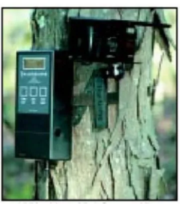
Figure 1: An output of what a video image processing device does. Source: Miovision, n.d. ...41 Figure 2: Example of a Passive Infrared Sensor installed within the large black pole next to the building wall. Source: Eco-Counter, n.d. ...44 Figure 3: Example of an Active Infrared Sensor. Source: TrailMaster, n.d. ....46 Figure 4: Manual Count Locations for Goal 1. ...57
1
Chapter One: Introduction
Austin, Texas, in the past few decades, has changed from a small and sleepy college-centered city to a rapidly growing with many industries that are attracting new residents from all over the United States. Austin has, historically, been a city that is dependent on automobile travel. This history of automobile travel is now at odds with how fast the city has been growing, leading to traffic congestion and ever-expanding and sprawling suburban development. In recent years, there has been interest in increasing the amount of people utilizing other modes of transportation in order to solve Austin’s traffic woes, which has led to the creation of several active-transportation promoting policies and City departments. One such department within the City is the Active Transportation and Street Design Division within the Austin Transportation Department, which is home to Austin’s Pedestrian Program, established in 2016.
The Pedestrian Program is the only program within the City of Austin that is devoted solely to pedestrian issues and planning within the City. Thus far, the program has been primarily concerned with pedestrian safety; with the release of the Pedestrian Safety Action plan this year, the program will soon be focusing on broader pedestrian issues. Namely, the Pedestrian Program would like to evaluate the walkability of Austin and collect data on pedestrian activity within the City that will help the City pass pedestrian-friendly policies and make improvements aimed at increasing the walkability of Austin. While there are many quantitative and qualitative measurements for evaluating walkability
2
available, the Pedestrian Program would like to focus on counting pedestrians within Austin. Pedestrian activity levels throughout the City would be tracked over time in order to determine if walkability is, in fact, increasing within the City. The goal would be to implement a permanent pedestrian counting program within the Pedestrian Program.
This report will explore the current state of pedestrian counting methods and present options to the Pedestrian Program for planning and implementing a pedestrian counting program. Chapter Two will provide a brief overview of why pedestrian planning is important, and how pedestrian counting can be beneficial for pedestrian planning. Following that, Chapter Three will discuss policies and programs at the City of Austin that would benefit from the data collected from a permanent pedestrian counting program before discussing the goals of the Pedestrian Program in implementing a permanent pedestrian counting program.
Chapter Four will present and examine the best and most common methods and technologies available for counting pedestrians, including the benefits, drawbacks, associated costs, and tradeoffs for each one. I will also discuss emerging new technologies that may be useful for pedestrian counting in the future. Then, this report will take each of the goals of the pedestrian counting program and determine which method is best suited for each goal.
Finally, Chapter Five will discuss next steps and things for the Pedestrian Program to think about, including analyzing the data, sharing the data, and evaluating the pedestrian
3
counting program. Following that, there will be a brief summary of the overall report with key takeaways. Then, the report will conclude.
4
Chapter Two: Planning for Pedestrians
WHY IS IT IMPORTANT TO PLAN FOR PEDESTRIANS?
For a majority of the last century, development within the United States has revolved around the automobile, to the detriment of people who would like to either bike or walk to their destinations. Reliance on the private car has led to sprawling cities and negative consequences for people and the environment. The Center for Disease Control and Prevention reports that 36.5% of adults in the United States were obese in 2011-2014 due to lack of physical activity (Ogden, 2016). Trapped greenhouse gas emissions increasingly make the planet warmer and potentially too warm to comfortably support human life in the future. Emissions from automobiles make up about 16% of the total greenhouse gas emissions in the United States (EPA, 2016). One way to reduce the number of auto trips that contribute to global greenhouse gas emissions is to promote active transportation alternatives, such as walking for all trips, not just walking for recreation. Komanoff et al (1993) find that between 1.2 and 5.0 percent of passenger vehicle emissions of CO, NOx, VOCs, and CO2 were annually offset by bicycling and walking (although this is a high estimate). Encouraging people to replace their automobile trips with active transportation modes is one way that cities can combat climate change.
Careful planning to encourage pedestrianism and to create walkable communities must consider a wide range of physical, environmental, social, and human factors. A city needs more than sidewalks to call itself walkable; the overall design of the streets and the surrounding environment must making walking a feasible and appealing alternative to
5
driving for many people. The appropriate pedestrian infrastructure and improvements, as well as proper maintenance of those facilities, would increase walking which can decrease vehicle miles traveled and provide positive benefits for cities and for people.
What kind of positive benefits could walkable cities provide? Walkable cities could contribute to increased traffic safety by increasing the number of pedestrians on the streets and changing the behavior of drivers so they respect pedestrians (Jacobsen, 2003). Encouraging people to walk more would lead to healthier lives; walking is an easy and free activity for most people (U.S. Department of Health and Human Services, 2015). Frank et al (2004) show that “increased levels of mixed use and corresponding moderate physical activity (i.e., walking) are associated with reduced odds of obesity” (p. 94). Walkable neighborhoods also enable people to reduce automobile use for commuting to jobs or running errands; when residents live closer to their jobs they can spend less of their income on transportation (Quednau, 2016; Leinberger & Alfonzo, 2012). Transportation costs are usually the second highest household expenditure; in Austin, Texas, for example, the average annual transportation cost per household is $12,264 (H+T Affordability Index, 2017). Walkable neighborhoods can contribute to positive mental and emotional health by encouraging social interactions between people on city streets (Watts et al., 2015; Finlay et al., 2015). Walkable places typically have higher housing values, reflecting the popularity of accessible neighborhoods. Other benefits of walking in lieu of driving include decreased traffic congestion and street noise (Rabl & de Nazelle, 2012; Giles-Corti et al., 2014).
6
Increasing walkability may have some negative consequences. Increased home prices resulting from increased pedestrian infrastructure could lead to gentrification and community displacement when current residents cannot pay increasing taxes and other rising homeowner costs. Careful planning, however, can help cities mitigate those negative impacts and ensure that pedestrian improvements benefit everyone in the city. Pedestrian planning can be done with every community in mind, with a focus on equity.
There are a variety of tools that cities can use to measure walkability that will aid cities in their pedestrian planning efforts. The Austin Pedestrian Program would like to implement a permanent pedestrian counting program as their first step in planning for a walkable city. This report focuses on the Program’s original goal: counting pedestrians and learning how pedestrian counting can be useful for the Pedestrian Program and the City of Austin as a whole.
WHAT IS PEDESTRIAN COUNTING AND WHY IS IT USEFUL FOR PLANNING?
Pedestrian counting refers to the practice of collecting pedestrian volume data: selecting a location or multiple locations, and counting each pedestrian that walks by. Counting can either be done manually or using automated devices. Cities have long used a variety of systems for collecting, summarizing, and disseminating motor vehicle traffic volumes, but those systems do not typically include pedestrian or bicycle volume data (Ryus et al., 2014). Cities typically collect pedestrian volume data for specific projects, rather than across a city as a whole. Transportation agencies that lack system-wide pedestrian volume data, however, do not know where pedestrian facilities are needed the
7
most or which facilities are most in the need of improvement. Collecting pedestrian volume data at random locations is not sufficient for calculating pedestrian levels throughout a city nor do the data allow cities to estimate what pedestrian volume levels may look like in the future.
It is important to differentiate between motorized (motor vehicle) and non-motorized (pedestrian) volume data for several reasons. First, non-non-motorized volumes fluctuate more from day to day than motor vehicle volumes, particularly due to the weather or other environmental variables. Day to day variability is also related to lower hourly pedestrian volumes compared to automobile volumes. Adjacent land uses tend to impact pedestrian volumes more than vehicular traffic because pedestrian trips are also usually shorter than trips made by automobile and typically have different purposes than automobile trips (Kuzmyak, Walters, Bradley & Kockelman, 2014). The peak periods for pedestrian trips and automobile trips may also not coincide. It is difficult to detect bicyclists and pedestrians in motorized counts because they are smaller than automobiles; do not always stay in sidewalks or bike lanes; sometimes move in unpredictable ways such as crossing streets where there are no marked crosswalks; may linger in front of sensors; and usually will travel closely together, which will make it difficult for the sensor to distinguish individual members of a group, and may lead to undercounting of pedestrians or bicyclists (FHWA, 2011; Ryus et al., 2014). Automatic vehicle counters are not likely to record pedestrians accurately for these reasons. Finally, it is also important to understand that the
8
methods used to count non-motorized vehicles differ from those used for counting automobiles; so traffic engineers may not have as much experience using these methods.
CASE STUDIES OF PEDESTRIAN COUNTS THAT HAVE VALUE FOR PLANNERS.
This section highlights case studies showing how cities or governmental organizations have used pedestrian counts for a variety of planning purposes. These case studies illustrate how pedestrian count data can be useful for different projects and programs, such as Safe Routes to School programs, yearly data analysis, or even the process of creating a Pedestrian Master Plan. Some of the case studies also involve bicycle counts, because many organizations combine pedestrian and bicycle counts in their programs; the case studies still offer insight that will help the Pedestrian Program plan and implement a pedestrian-only counting program. Additionally, some of the case studies do not necessarily show that walking increased when the city focused on pedestrian counts, but how the pedestrian counts were useful for planning purposes and evaluation of programs and policies. Altogether, the case studies will provide valuable lessons to Austin’s Pedestrian Program that will help them plan their own counting program and ensure they capture valuable pedestrian data.
California’s Safe Routes to School Program
Many communities, states, and even the federal government have official Safe Routes to School programs that are aimed at increasing the number of children walking to and from school. The state of California has one such program, which funds six type of infrastructure improvements: sidewalk improvements; traffic calming and speed reduction
9
projects; pedestrian and bicycle crossing projects; bicycle facilities; traffic control devices; and traffic diversion projects for schools statewide. In a study of 10 California elementary schools that received Safe Routes to School improvements, Boarnet, Day, Anderson, McMillan, and Alfonzo (2005) determined the expected outcomes of each improvement type funded by the Safe Routes to School Program, and measured the actual outcomes of each improvement type against the expected outcomes. The authors surveyed parents and counted pedestrians before and after each improvement was installed in order to gauge whether the projects had shown evidence of success. Most of the sidewalk gap closure projects resulted in an increased numbers of children walking to and from school as well as decreased numbers of children walking in the street or on the shoulder once the missing sidewalk was constructed (Boarnet et al., 2005). However, the other types of Safe Routes to School projects did not show as large an impact.
Santa Monica’s Pedestrian Demand Index Model
In Santa Monica, California, the city used the data collected from biannual pedestrian counts, along with other data, to create a Pedestrian Demand Index map that shows which areas of Santa Monica are likely to see the highest rates of pedestrian numbers and demand for pedestrian improvements (City of Santa Monica, 2016). Santa Monica’s Pedestrian Suitability Index Demand Analysis included demographic information, social equity data, land use data, special district information, pedestrian counts, and physical geography data. The city was able to combine the demand index with an analysis of existing pedestrian infrastructure in order to see which areas would benefit the most from
10
improvements, especially if they were crucial connections to elsewhere. Santa Monica was then able to use these data to create their Pedestrian Action Plan for future pedestrian planning.
Jacksonville, Florida’s Pedestrian Safety Analysis
In 2016, the Robert Wood Johnson Foundation sponsored a program called “Technology for Healthy Communities,” which provided support for communities to implement technological solutions that would target their most dire heath issues. One of the beneficiaries of this program was Jacksonville, Florida, who partnered with Numina, the Health Planning Council of Northeast Florida, and the Clinton Health Matters Initiative to install Numina sensors in order to collect bicycle and pedestrian counts and other data. Jacksonville wanted to collect these data because the city is the third most dangerous in the United States for pedestrian safety; by collecting these data, they could pinpoint opportunities for investment that would improve pedestrian safety while also encouraging residents to be more physically active (Camesas, 2016). Jacksonville also sought to improve health outcomes and reduce the number of residents suffering from chronic diseases as a result of this initiative. Jacksonville installed 22 Numina sensors around the city at 11 different sites that had been identified as high-risk with significant pedestrian safety issues in underserved neighborhoods. These data showed Jacksonville that the intersections believed to be high risk actually were not very dangerous when crashes were compared to the pedestrian volumes identified at those locations.
11
The National Bicycle & Pedestrian Documentation Project
Established in 2003 by Alta Planning + Design and the Institute of Transportation (ITE) Engineers Pedestrian and Bicycle Council, the National Bicycle and Pedestrian Documentation Project (NBPDP) is a bicycle and pedestrian count and survey project that occurs every year. The main objectives of the NBPDP are to create a standardized methodology for conducting bicycle and pedestrian counts and surveys that could be easily replicated in any community; create a freely available national database for the count data collected as a result of the standardized methodology; and use the data collected to analyze potential relationships between various elements and bicycle and pedestrian activity (NBPDP Project Description, 2009). The NBPDP was started because there was a need for more guidance and documentation pertaining to bicyclist and pedestrian data. Without data on pedestrian behaviors, it is hard to justify or quantify the effects of investing in pedestrian facilities and improvements in addition to investing in automobile infrastructure.
The NBPDP created free standardized and consistent bicycle and pedestrian count and survey forms for agencies and organizations to use if they choose to participate in the NBPDP’s National Documentation Days, which occurs in early September each year. September was chosen for the national count date because higher volumes of bicyclists and pedestrians tend to occur during that month (NBPDP Instructions, 2010). There is also an option to do additional surveys and counts during the months of January, May, and July in order to collect seasonal data.
12
After participating agencies and organizations conduct their pedestrian and bicycle travel surveys and counts, they can send their collected data to the NBPDP, where it will be added to a national database. This national database is freely accessible for any organization that participates in the NBPDP. The NBPDP will also provide summary reports to everyone who participated. Additionally, for agencies that use one of Eco-Counter’s automatic counting devices, the NBPDP will “provide a free summary report of the data in exchange for submission of the annual automatic count data to the project” (“National Bicycle and Pedestrian Documentation Project,” 2016). Once all of the data have been collected from all of the participating organizations, Alta Planning + Design will create an annual Summary Report of Trends for public viewing, which will include information such as volumes by user group; comparison of volumes to location attributes; understanding of trip purpose; and understanding of trip origin, among other data.
As of January 2009, the NBPDP had collected data on approximately 310 counts in about 93 different communities nationwide (“Fact Sheet and Status Report,” 2009). By participating in the annual count dates for the NBPDP each year, the City of Austin would be contributing a national database on pedestrian count data, which would benefit all the communities that participate. The more data that is collected on pedestrian behavior and activity levels nationwide, the easier it will be to quantify the positive benefits of increasing the walking mode share for transportation and to justify investments in pedestrian improvements and facilities.
13
San Diego County, CA
In 2006, Caltrans, the Traffic Safety Center at the University of California Berkeley, and Alta Planning + Design all collaborated on developing a bicycle and pedestrian demand model for San Diego County, known as the Seamless Travel Project. For the Seamless Travel Project, bicycle and pedestrian counts and intercept surveys were conducted over two years; the purpose of the project was to gauge the effects of variables such as socio-demographic factors or land use mix on bicycling and walking levels throughout the county (Jones et al., 2010). San Diego County was selected to be the focus of this project because the county had data available from previous bicycle counts that could be used to test and validate the counts conducted for this project. Additionally, San Diego County also had a public GIS database that is updated frequently, which was useful for the Seamless Travel Project.
The variety of data collected is useful for comparing trends and location attributes from year to year. The project involved two manual counts at 80 locations around San Diego County during peak periods in 2007 and 2008; a year of automated 24-hour counts at five locations from August 2007 to July 2008; and intercept surveys. The 80 count locations (a mixture of historic bicycle count locations and new locations) were chosen based on the “presence and type of bicycle facilities, high pedestrian crash areas, areas identified for future smart growth, locations near transit stops, locations near planned or recently completed bicycle and pedestrian projects, and variety of land uses and
14
demographics” (Jones et al., 2010, p. 38). The counts all took place during peak periods for bicyclists and pedestrians during the day.
In addition to the manual and automated counts, intercept surveys were conducted, and 367 surveys of pedestrians were collected from 25 count locations (Jones et al., 2010). The pedestrians surveyed were chosen randomly. The results of the intercept surveys showed that 63% of the trips were transportation-related. Major factors involved in pedestrians choosing to not walking more often included traffic, crime, poor driver behavior, lack of facilities, and poor lighting. A majority of the pedestrians most likely walked for economic reasons. Finally, Hispanic and Latino people were more represented in these surveys than the entire county (Jones et al., 2010).
As a result of the pedestrian counts and surveys taken for the Seamless Travel Project, Jones et al. learned several important lessons for pedestrian counting. First, the reasons why people chose to walk were similar to the percentages found for household travel and private vehicle trips in general; i.e., people who walk were walking for a variety of reasons, not just recreation. Additionally, the location of the automatic counters would influence the data collected, since “pedestrian activity is affected by facility type (pathways, sidewalks), surrounding land use, weather, time of year, and many other factors” (Jones et al., 2010, p. 84).
FHWA Bicycle-Pedestrian Count Technology Pilot Project
In 2015, the Federal Highway Administration (FHWA) started a Bicycle-Pedestrian Count Technology Pilot Project that lasted for one year. The pilot project was intended to
15
assist Metropolitan Planning Organizations (MPOs) in quickly planning and implementing effective automated counting programs for pedestrians and bicyclists with limited funding as a model for other agencies and entities as they planned and implemented their own counting programs (Baas, Galton, & Biton, 2016). Ten MPOs were chosen for the pilot project, based on their population size (at least one million people) and their lack of a formal bicycle-pedestrian counting program or experience in conducting such counts. Through the study, each MPO received $20,000 “to purchase and install bicycle and pedestrian counting equipment, to gather baseline count data, and to consider how these data may be used to support multimodal planning and project development” (Baas, Galton, & Biton, 2016, p. 1).
This pilot project offers insightful lessons for the Pedestrian Program, since there were a variety of MPOs involved in the project, and they all took different approaches to planning and implementing their bicycle and pedestrian counting programs. For example, two MPOs rotated their counters from location to location within their regions in order to capture the differences in land use types, densities and building types. A different MPO, by contrast, decided to use only regional trails and pathways for all of their counts. Some MPOs chose to conduct counts on recently installed or future infrastructure projects in order to quantify the impacts of those improvements on alternative transportation in their regions. Other MPOs chose locations where manual counts had been done previously in order to receive more data about those locations and so the automatic counter data could be validated against the previous manual counts. Overall, there were more than 170
16
locations used during the pilot project among the ten MPOs, with most of the MPOs choosing locations where the volumes of bicyclists and pedestrians were highest. Several of the MPOs also coordinated with local agencies and organizations when choosing the count locations.
The MPOs that participated in this study learned a lot about planning and implementing counting programs and collected useful data that aided them in their analysis. Among all of the MPOs, the data were used to create a baseline at the selected count locations; pinpoint various patterns based on the time of day or week; determine where there were safety issues for pedestrians; evaluate the impact of improved infrastructure; and compare pedestrian to automobile counts in order to ascertain modal share. One MPO created summary reports that looked at count volumes in relation to the weather, seasons, and land use conditions; this same MPO also took counts before and after paving a trail in order to gauge the impact of the trail improvement. Two MPOs reported that the count data they collected were useful when applying for federal funding, such as the Transportation Alternatives Program (TAP) or Congestion Mitigation and Air Quality (CMAQ) funds; one of these MPOs also noted that the data were helpful in the creation of an Alternative Transportation Plan (Baas, Galton & Biton, 2016). Overall, the MPOs, especially the ones that had conducted manual counts in the past, benefitted from significant time and labor savings as well as increased amounts of data because they were able to track pedestrians and bicyclist volumes over a longer period of time. The pilot project allowed the MPOs to track these data more efficiently.
17
SUMMARY
Around the country, many entities and agencies are using pedestrian count data to aid in their planning processes for improving pedestrian facilities within cities. Since Austin does not have a comprehensive and permanent pedestrian counting program yet, it is beneficial to learn from other cities and organizations about what they have done and what lessons they have learned from implementing their own pedestrian counting programs, as the case studies showed. Collecting baseline pedestrian counts and tracking the changes in pedestrian activity levels over time will enable the Austin Pedestrian Program to assess what impact, if any, their pedestrian policies and projects have and adjust their pedestrian planning processes if the desired impact is not being achieved. Additionally, the Pedestrian Program can determine which projects have the greatest impact and prioritize those kinds of projects in order to achieve a greater impact with the same budget. For example, it would be useful to track changes in the number of people walking in the event of major road projects or closures, to see if walking is a viable alternative transportation option in those events. Pedestrian count data will also allow the Pedestrian Program to determine which areas are actually in need of pedestrian improvements in order to increase pedestrian safety, rather than spending money on locations that are already comparatively safe. One of the more interesting uses for the pedestrian count data is in applying for federal funding; the Austin Transportation Department will usually apply for federal funding from the Capital Area Metropolitan Planning Organization (CAMPO), and these data could make their projects even stronger
18
when they apply. While these are not all of the ways that the Pedestrian Program could use pedestrian count data, these would likely be the biggest uses of any collected data. Before collecting any data, however, the Pedestrian Program should have very clear goals and objectives in mind for their pedestrian counting program, an issue I cover in the next chapter.
19
Chapter Three: The City of Austin’s Pedestrian Goals
This chapter provides a brief overview of the factors that led to the City of Austin’s Pedestrian Program’s desire to create a Pedestrian Counting Program. The city wants to improve infrastructure conditions for pedestrians in Austin, and this objective is reflected in various plans, policies, and actions that the city has adopted over the last few years. I describe the various programs and their data needs and I end by pulling all the themes together.
AUSTIN,TEXAS
Imagine Austin, Austin’s comprehensive plan, was adopted in 2012; expanding
transportation mode choices is a high priority of the plan. The plan’s vision statement states that Austin is a livable city, and that future development should occur in “connected and pedestrian-friendly patterns supporting transit and urban lifestyles” while also reducing sprawl (Imagine Austin, 2012, p. 84). Another component of the vision statement asserts that Austin is a mobile and interconnected city that “promotes safe bicycle and pedestrian access with well-designed routes that provide connectivity throughout the greater Austin area;” the plan sees the cycling and pedestrian routes as a critical element of the overall regional transportation network (Imagine Austin, 2012, p. 86). Imagine Austin states that it is important to ensure that any new development or redevelopment within Austin will be pedestrian-friendly and connected to the rest of the city because pedestrian-friendly development will help address “many of the challenges facing Austin, including motor vehicle congestion, commute times, air quality, transportation costs, lack of connectivity,
20
bicycle safety, and recreational access” (Imagine Austin, 2012, p. 98). Overall, the comprehensive plan provides a broad guideline for increasing pedestrianism within the city, and influences all other programs and policies related to pedestrianism and walkability in Austin.
Following the adoption of Imagine Austin, a Complete Streets policy was adopted by the City in June 2014. Complete Streets refers to streets that are “inviting and accessible places to walk, bike, or ride for people of all ages and abilities” (“Complete Streets,” n.d.). The Complete Streets ordinance is intended to complement Imagine Austin and advocates for better mobility options and compact and walkable development patterns as tools for increasing the overall quality of life for all of Austin’s residents. The policy seeks improvements in livability, affordability, equity, as well as the quality of the environment. Adopting the Complete Streets policy for the city means that any new roadway construction or roadway reconstruction must include pedestrian and bicycle improvements, green infrastructure, increased connectivity to the overall street grid, public transportation facilities, and other such improvements.
The Urban Trails program released their Master Plan in 2014, which “envisions a system of Urban Trails that connects all of Austin by allowing residents to go from one end of the City to the other in a safe and healthy way” (Urban Trails Master Plan, 2014, p. ii). These Urban Trails would complement the existing on-street pedestrian network, “giving residents the opportunity to use active transportation to travel greater distances across all parts of Austin and creating a true ‘8 to 80’ network, where an 8 year old child
21
can walk or ride with an 80 year old” (Urban Trails Master Plan, 2014, p. ii). Increasing the walkability of Austin and the number of pedestrians on the streets means that City staff needs to consider all motives for walking trips, including recreation.
The City of Austin has a Great Streets Development Program within the Planning and Zoning Department, similar to the Complete Streets policy, which “provides a mechanism to improve the quality of downtown streets and sidewalks, aiming ultimately to transform the public right-of-ways into great public spaces” (“Great Streets Program,” n.d.). The program allows the city to work together with private developers to share the costs of needed streetscape improvements that transform public streets into high quality urban streets. The program, however, is limited to only downtown streets (“Great Streets Program,” n.d.). Austin’s Great Streets include design elements such as “sidewalks 18 or 32 feet in width; street furnishings that include benches, bike racks and trash receptacles; and street trees that are spaced so that there is a contiguous canopy at maturity to provide shade” (“Great Streets Program,” n.d.). The program is funded by the Great Streets Parking Meter Fund, which sets aside 30% of the parking revenues collected in downtown within the program’s boundaries to provide assistance to the development community to implement the Great Streets standards; approximately $400,000 is generated each year from this fund (“Great Streets Program,” n.d.).
In 2016, Austin passed an update of their Sidewalk Master Plan and ADA Transition Plan, which describes asset management policies for sidewalks within City of Austin right-of-way (Sidewalk Master Plan, 2016). Currently, the sidewalk network has
22
roughly 2,400 miles of existing sidewalk but lacks approximately 2,580 miles of sidewalk. The Sidewalk Master Plan is implemented by the Austin Public Works Department’s Sidewalk Program; one of the goals of the plan is to encourage walking as an alternative mode of transportation. The plan has a ten-year target to install all very high and high priority sidewalks within ¼ mile of all identified schools, bus stops, and parks, including both sides of arterial and collector streets and one side of residential streets. This would equate to approximately 390 miles of new sidewalks, or 39 miles of sidewalk installed each year of the ten year period (Sidewalk Master Plan, 2016). The Sidewalk Program and the Special Projects Division, also located within the Public Works Department, would benefit from pedestrian count data as a way to benchmark the success of the Sidewalk Master Plan in building needed sidewalks within Austin, and to show how new or improved sidewalks are actively contributing to increased pedestrian levels within Austin.
Austin voters approved a Mobility Bond in 2016, which earmarked $720 million for improvements to transportation and mobility throughout Austin, with $482 million specifically for corridor improvements (“Corridor Program Implementation Office,” n.d.). The mobility bond has three major components: Local, Corridor, and Regional improvements for transportation within the city. The corridor program seeks to improve major corridors within Austin. The local mobility improvements include sidewalks, Safe Routes to School, Urban Trails, as well as Vision Zero Fatality Reduction Strategies (“2016 Bond Programs and Projects,” n.d.). Pedestrian improvements for all portions of the mobility bond may include installation or rehabilitation/replacement of curb ramps,
23
sidewalks, curbs, driveway aprons; improvements to non-motorized, multi-use pathways; improvements to dangerous intersections; and other pedestrian improvements.
The Safe Routes to School program, housed within the City of Austin’s Public Works Department, educates students on pedestrian and bicycle safety and provides crossing guards at crucial intersections (“Public Works Department Programs,” n.d.). The aim of the program is to eliminate barriers that preclude children from walking to school. This is important, since “the percentage of children walking or bicycling to school nationwide has dropped precipitously, from approximately 50% in 1969 to just 13% in 2009 (“Quick Facts and Stats,” n.d.).
The City of Austin also adopted the Vision Zero Action Plan in 2016. Vision Zero is based on the principle that there should be no fatalities or serious injuries on roadways and streets resulting from crashes. The Vision Zero Action Plan has set a goal of eliminating all deaths and serious injuries from crashes by 2025. This goal necessitates a multi-pronged effort among various City departments and other agencies to redesign the transportation system so that when people make mistakes on the road, those mistakes are not fatal. This Vision Zero Action Plan adopts citywide policies related to education, engineering, enforcement, transportation planning, land-use planning, and street design (Vision Zero Action Plan, 2016). While Vision Zero focuses on safety improvements, those safety improvements could lead to increases in pedestrians if people perceive streets to be safe and comfortable for walking. Pedestrian count data would benefit the Vision Zero
24
Program by providing context for pedestrian crashes within Austin; if the program knows where people are walking within the city, planners can account for pedestrian exposure.
CITY OF AUSTIN PEDESTRIAN PROGRAM
Austin Transportation Department’s (ATD) Active Transportation and Street Design Division, established in July 2016, oversees the City’s Bicycle Program, Vision Zero Program, Bike Share, Street Design and emerging Pedestrian Program. Existing pedestrian efforts were fragmented and there was no comprehensive program for coordinating them. Additionally, while ATD had a strong Bicycle Program in place, ATD leadership felt that the need for a separate program specifically focused on providing solutions that could address the nuanced challenges faced by people walking in Austin. Other factors that led to the establishment of the Pedestrian Program were, 1) the trends observed in Austin’s peer cities to have dedicated pedestrian programs; 2) the strong community voice for pedestrians that was present in the city in the form of an emerging advocacy community, including the Pedestrian Advisory Council (PAC); and 3) the desire to support the Vision Zero Action Plan and Program (L. Dierenfield and J. Meyer, personal communication, July 6, 2017).
The Pedestrian Program is still a new program, with one dedicated Pedestrian Coordinator. The primary focus for the program thus far has been the creation of the Pedestrian Safety Action Plan (PSAP), which will serve as a holistic strategy for addressing pedestrian safety in Austin in support of the Vision Zero Program. The program is
25
concerned with pedestrian safety, but the program’s purview covers many other aspects of pedestrianism.
According to ATD staff interviewed for this report, the main objectives of the Pedestrian Program are to:
Goal 1: Encourage walking within Austin;
Goal 2: Create pedestrian friendly places through placemaking;
Goal 3: Advocate for pedestrian issues in interactions with other city departments; and
Goal 4: Influence both policy and programmatic activities within the city (L. Dierenfield and J. Meyer, personal communication, July 6, 2017).
For example, the Pedestrian Program has been recently creating a Pedestrian Crossing Improvement Program, which aims to create safer pedestrian crossings, using low cost treatments at large numbers of locations across the city. The Pedestrian Program has also been involved in the effort to overhaul Austin’s Land Development Code, known as CodeNEXT, to ensure that the new land development code will promote walkability. In the future, the Pedestrian Program would like to create a Pedestrian Master Plan for Austin and establish a dedicated Placemaking Program.
The Pedestrian Program does have a number of challenges including the lack of resources, both in terms of staffing and funding. There is little awareness and understanding of the program and its purpose within the city and a lack of available data. Austin’s auto-oriented land use patterns and driving culture also makes creating a walking culture very
26
challenging in all areas of the city. It is also difficult to articulate the needs of the program and turn conceptual support from other stakeholders into actual support for the program (L. Dierenfield and J. Meyer, personal communication, July 6, 2017). While the city does have access to pedestrian crash data, there are few data on overall levels of pedestrian activity or pedestrian travel patterns within the city. Some of these challenges stem from the infancy of the program and are expected to be overcome as time, attention, understanding and resources come online.
The Pedestrian Program staff would like to implement an ongoing and sustainable pedestrian counting program as a way to gather more information and data to support their policies. Having a counting program in place will provide concrete data to measure the successes of the program’s recent efforts to promote walking in Austin and increase pedestrian safety on roadways. The collected data could be used to validate and calibrate a pedestrian demand model; measure the impact of specific pedestrian improvement projects; predict where crashes might happen; and also be used to solicit more support from other city departments and outside organizations. While the Austin Transportation Department has conducted pedestrian counts in the past, those counts were usually conducted for a specific project, or as part of a traffic study, and not specifically for evaluating walkability or gathering baseline pedestrian volume data (E. Bollich, personal communication, July 11).
The Austin Transportation Department does currently have several automatic counting devices installed throughout the city that count both bicyclists and pedestrians.
27
There are two different kinds of counting devices currently installed, one of which is the Eco-Counter Nature” device. Typically a permanent installation, the “Multi-Nature” device combines the PYRO passive infrared sensor (the sensor is housed in a post) with Eco-Counter’s ZELT inductive loop. The Urban MULTI device is able to differentiate between pedestrians and bicyclists through a subsystem of the device called the Smart Connect, which “analyses the signal from both sensors in order to count and classify each user” (“MULTI Urban,” n.d.). This device is best suited for multi-use pathways with high volumes of pedestrians and bicyclists. There are currently six “Multi-Nature” devices installed within the central core of Austin, all located on urban trails. The other Eco-Counter device currently in use within Austin is the “Urban Zelt” device, which only counts bicyclists. The Austin Transportation Department has a website hosted by Eco-Counter that shows the number of people walking and biking at these locations, broken down by mode. The volumes can be further broken down by month, week, or day as well.
Besides the installation of permanent automated counters in Austin, there have been one-time bicycle counting projects where the Austin Transportation Department was able to expand the scope of the project so that pedestrians could also be counted.For example, Austin was one of the ten cities chosen for the PeopleForBikes Big Jump Project, which is assisting those ten cities in quickly and radically transforming their bicycling infrastructure and expanding their outreach efforts at the same time, in order to double or triple the number of people bicycling in specific areas of those cities over a three-year period (“Big Jump Project,” n.d.). As a part of the Big Jump Project, the Austin Transportation
28
Department was able to receive funding to conduct 24 hour video counts at 50 locations throughout the central core of Austin through a contractor. While the video recording counts were initially focused on counting bicyclists, the Austin Transportation Department was able to expand the scope so that pedestrians could be counted as well. The video counts were done using regular video cameras installed at the chosen locations; the pedestrians shown on the videos will be manually counted by outside staff.
The Capitol Area Metropolitan Planning Organization (CAMPO), the region’s Metropolitan Planning Organization (MPO) has also conducted pedestrian counts within Austin in the past. CAMPO currently operates a bicycle and pedestrian monitoring program in partnership with the Texas Transportation Institute and the City of Austin (“Active Transportation,” n.d.). In 2010, CAMPO conducted manual pedestrian counts at several locations within Austin. CAMPO and the City of Austin also jointly operate an Eco-Counter PYRO-Box in Austin, located on the Lance Armstrong Bikeway at Waller Creek. The PYRO-Box has been in place since December 18, 2012, recording over 1.6 million individuals through July 2017. The count data are available to the public through a web viewer accessible from the CAMPO website.
The pedestrian count data collected by the City and through CAMPO are useful to the City, but are not sufficient for the Pedestrian Program’s needs. It is essential to collect sustained pedestrian data over a long period of time from several locations around the entire city in order to acquire an accurate picture of what pedestrian activity levels are really like within Austin. Thus far, there has not been a comprehensive effort by the City of Austin to
29
conduct pedestrian counts throughout the city in order to draw any conclusions about pedestrian activity throughout the city. By implementing a permanent pedestrian counting program, the Pedestrian Program hopes to collect long term pedestrian activity data that will benefit multiple city departments and support current and future pedestrian-oriented policies or programs.
According to Pedestrian Program staff, the main objectives for a pedestrian counting program are to:
Goal 1: Track changes in walking levels over time citywide;
Goal 2: Use the counts to help develop a citywide model of pedestrian activity;
Goal 3: Track walking levels and behavior changes at specific locations (e.g. corridors or commercial districts);
Goal 4: Conduct before/after studies when installing new pedestrian facilities in order to assess the impact of the improvements; and,
Goal 5: Put pedestrian crash data into context (i.e. normalize crash rates by pedestrian activity to better understand where the highest risk areas are for pedestrians. (J. Meyer, personal communication, July 10, 2017).
Staff indicated a desire for a pedestrian counting program that would ideally cover a wide geographic area. They recognize that, due to resource constraints, there may be limitations on how expansive the initial counting program can be, especially early on in the program’s existence. One priority for planning the pedestrian counting program is to set it up in a way that would allow for long-term counts across the city in order to track
30
changes in pedestrian levels, but also be flexible enough to be able to move counters to other locations for short counts for specific projects (J. Meyer, personal communication, July 10, 2017).
SUMMARY
The City of Austin has a variety of plans, departments and programs that all promote pedestrianism in some way. This report outlined several of the plans and policies that the City of Austin has published and established that relate to pedestrianism already. Behind those plans and policies, there are City departments, programs, and offices carrying out the plans and policies. These departments and programs include the Sidewalks, Urban Trails, and Safe Routes to School Programs within the Public Works Department; the Planning and Zoning Department, especially the Great Streets Program; the Economic Development Department; and the Street Banner, Arterial Management Division, and Vision Zero programs within Austin Transportation Department. Each department, program, division, or office all have a different purpose, but each has a mission that in some way promotes pedestrianism. Based on conversations with City staff, Table 1 below identifies how a permanent pedestrian counting program would benefit each of these programs.
31
Program/Vision (Department)
How would they benefit?
Sidewalks and Special Projects Program (Public Works Department (PWD))
Pedestrian counts can be used to prioritize where new sidewalks should be built or where existing sidewalks need to be improved or replaced.
Urban Trails Program (PWD)
Pedestrian counts would be analyzed to see which Austin trails have the most traffic, which helps the program plan future trails. The data would also be used to gauge the success of projects and track changes in usage over time.
Safe Routes to School Program (PWD)
Pedestrian counts can be used to track how many children are walking to and from school and that data can justify safety improvements for children who are walking to and from school. Planning and
Zoning
Department (P&Z)
Pedestrian counts would help them understand latent demand for walking, if the built environment serves all people (or only the “Strong and Fearless/”Enthused and Confident” walkers), and help them come up with better designs, standards and code, and plans (corridor, district, neighborhood).
Redevelopment Division (Economic Development Department (EDD))
Pedestrian count information would help the department
determine how foot traffic impacts the economics of businesses within a business district, and provide information on if people walk to their destination or park and overall sales as it relates to number of customers and foot traffic within a district.
Street Banner Program (ATD)
Pedestrian counts could assist with promoting the program, opening new banner districts, and developing a new sub-program of pedestrian-level banners in areas with pedestrian counts that are higher than vehicle counts.
Arterial Management Division (ATD)
Pedestrian count data would allow the Division’s PHB program to justify the installation of PHBs where there is a high volume of pedestrians but a lack of safe pedestrian street crossings.
Vision Zero Program (ATD)
Pedestrian counts would give the program a denominator for calculating injury and fatality rates for pedestrians. Calculating these rates would help the program prioritize engineering, enforcement, and education activities.
32
The pedestrian counting program is intended to help the Pedestrian Program first and foremost. The pedestrian data collected from this pedestrian counting program, however, can benefit other departments as well. The Pedestrian Program is not a silo onto itself; the Program will seek to collaborate with other departments so that the Pedestrian Program is not duplicating data collection underway in other city programs while providing those agencies and programs with valuable pedestrian data they may not be collecting. The Pedestrian Program must take a multi-pronged approach to developing their pedestrian counting program to meet their needs and those of other city departments. The program will need to collect different types of pedestrian data for different reasons over different time periods; they cannot create therefore, a one-size-fits-all pedestrian counting program. Capturing relevant data for estimating pedestrian activity levels citywide, for example will not necessarily provide appropriate data for examining dangerous intersections within the city – the data needs are very different. The Pedestrian Program should choose specific counting methods that match specific city goals, keeping in mind that counting methods may overlap for some of the goals. In the next chapter, I present an overview of some of the common pedestrian counting methods that would be best suited to the Pedestrian Program’s goals and needs, as well as utilizing emerging technologies that may be useful.
33
Chapter Four: Methods of Determining Pedestrian Volumes
This chapter briefly examines various methods available for counting pedestrians and evaluates the benefits, drawbacks, and associated costs of each one. Different types of counting methodologies suit different goals, and it is important to determine which counting method suits each particular goal for the pedestrian counting program. There are both manual and automated counting methods available to count pedestrians. To manually count pedestrians, cities conduct in person counts either in the field or evaluate pedestrian activity recorded on video. Automated count technologies include video image processing; pressure/acoustic pads (also known as Piezometric pads); laser scanning devices, passive infrared sensors; active infrared sensors; radio beam devices; or a combination of any of the above technologies.
There is no perfect technology available for counting only pedestrians. Many of the available technologies described in this chapter cannot distinguish between pedestrians and bicyclists, so their usefulness in counting pedestrians is limited to pedestrian-only areas, such as sidewalks or trails. However, it is possible to use one technology that counts both pedestrians and bicyclists in tandem with a bicycle-only counting technology in an area with both bicyclists and pedestrians in order to capture the volume of pedestrians and bicyclists, by removing out the number of bicyclists from the overall number of pedestrians and bicyclists. This means that the Pedestrian Program would have to coordinate with the rest of the Active Transportation department on capturing the bicyclist data and then manually capture the pedestrian data by subtracting the bicyclist data from the pedestrian
34
data. Using two technologies requires more resources than using just one technology, as well.
Some of the technologies mentioned are also primarily used indoors or work best indoors, which is not useful to the Pedestrian Program now. These technologies, however, could theoretically be used outdoors and could be useful in the future. Each technology described below does have drawbacks that limits how, where, and how often these technologies can be used.
The next section explores the best methods and technologies for capturing pedestrian data. Some technologies, such as pressure pads, laser scanning devices, and radio beam devices, will not be discussed here because they do not fit the Pedestrian Program’s current needs; because there is limited information on their successful use for outdoors pedestrian counting; they are typically used to count pedestrians indoors (for example, in shopping malls); and they are sensitive to environmental conditions. First, I describe manual counting methods, the only way to truly count just pedestrians without any location limitations or technology constraints. I then look at combination technologies which count both pedestrians and cyclists at the same time and then require an additional effort to separate pedestrian from cycling data. There are technologies which can be used to just count pedestrians but they face location constraints (they can only be used where no cyclists are present) so that a combined approach is often needed. I conclude by looking at emerging and innovative resources that may be useful for pedestrian counting in the future.
35
MANUAL COUNTS
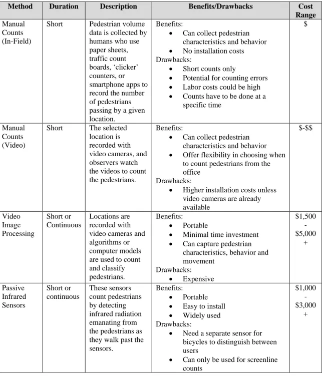
The first kind of manual pedestrian counting involves trained observers counting the number of pedestrians passing by a given location using paper sheets, traffic count boards, ‘clicker’ counters, or smartphone apps to record the numbers (NASEM, 2014). These counts generally take place over one to four hours with intervals of roughly 15 minutes each; they can take place at screenline, intersection, or midblock locations. Screenline refers to an imaginary line across the intersection or roadway; when pedestrians cross this imaginary line, they are counted. In-field manual counts tend to be the most widely used method for collecting pedestrian volume information since no equipment is needed, and the counts can be very accurate as long as the field observers are well-trained (FHWA, 2011). There are, however, drawbacks to in-field manual counting, including the high labor costs, the logistics of conducting long-term or permanent counts, and an inability to authenticate or double-check data, especially if volunteer staff are used.
The second form of manual pedestrian counting involves the use of video recordings, in which the selected location is recorded with video cameras, and then, observers watch the videos and count the pedestrians that appear on the screen. Recording the number of pedestrians can be done using paper, a handheld counter, or a computer with an additional specialized keyboard made specifically for traffic counts. Manual counting through video recordings offers more flexibility than in-field counts because it is possible to re-watch footage, which increases the accuracy of the counts and allows observers to verify the data; it is also more flexible in that it allows observers to watch the footage when
36
it fits their schedule, rather than having to stand outside for several hours. Labor costs can be lower than on-site manual counts because observers can quickly skim through inactive periods on the recordings (FHWA, 2011). There are some problems with this form of manual pedestrian counting; purchasing, installing, and maintaining the video cameras used can be cost-prohibitive. Costs may be reduced by using regular video cameras as long as they are installed in secure boxes; for more detailed video recordings, higher quality cameras are needed (Ryus et al., 2014). Other equipment needed for video counting includes a computer that is able to play videos as well as computer software that is suitable for recording counts. Cities have to consider the tradeoffs between labor and capital costs in using video manual techniques.
The two forms of manual counting are similar, in that they are best suited for short duration counts; both can be used to gather other information about pedestrians, such as gender, direction of travel, usage of a stroller or walker, or pedestrian behavior such as walking against a pedestrian signal. Labor costs are higher, however, than for automated counting technology. There are some key differences that may make one form a better choice than the other one, depending on the situation. Labor costs (staff time needed to train counters and for counters to do the counts) are high for both forms, but in different ways. City staff conducting counts outside take time away from other priorities and lose time spent traveling to count locations and setting up. Using video recordings to count pedestrians does not require staff to leave the office so they can fit the counts into their
37
schedule. It still takes more time, however, to analyze the video recordings than it would to stand outside and count pedestrians for several hours.
One way to reduce staff labor would be to use volunteers to conduct the manual counts in the field or through videotape recordings. Volunteers could be useful if the Pedestrian Program would like to conduct many manual counts all at one time, and the volunteers could come from local school programs or from organizations related to walkability and pedestrianism. Of course, the Pedestrian Program would have to factor in the time and cost of training the volunteers as well as managing the data the volunteers collect. Additionally, it is important to make sure that volunteer observers understand exactly how to conduct a count in order to avoid the effects of unconscious or intentional bias with both forms of manual counts (human and video) for both forms of manual counting. Experts counsel that there should be more than one volunteer at locations with high pedestrian volumes in order to increase the accuracy of the counts (NASEM, 2014). Several studies that compared field counts to video counts found that, while field counts tended to undercount pedestrians compared to video counts, having the proper equipment and training could reduce that undercounting. Focusing specifically on the number of pedestrians in a location (rather than also capturing person attributes for example) and using ‘clicker’ devices increased the accuracy of the field counts. Overall, for new pedestrian counting efforts, manual counts tend to be the best method to start off with, because the associated costs are low and the manual count locations can form the basis for automated count locations in the future (Ryus et al., 2014).
38
AUTOMATED COUNTING METHODS
This section discusses different technologies that cities can use to capture pedestrian data. All of these methods can capture pedestrian data, but it is important to note that none of the methods can be used for counting only pedestrians in any kind of location at any time. One method uses only one technology to record multiple modes, including pedestrians, of travel through an intersection. The other methods, while they do capture pedestrian volume data, can only do so under certain conditions, and may need the use of a second technology for counting and then removing bicyclists from the data set in areas where there is a mix of pedestrians and bicyclists. Using two technologies is useful for situations where there is a mix of traffic modes because no current automated technology can separately detect bicycles and pedestrians and provide individual counts for each (NASEM, 2014). Using a tandem technology can also be useful for agencies that would like to count both pedestrians and bicyclists but obtain mode-specific data; doing so would allow for more efficient use of resources.
Automated counting technologies also raise the issue of undercounting or overcounting. It may be possible to offset or overcome the counting errors through adjustment functions, that is, equations used to adjust raw automated count data to reduce the amount of errors present in the data, as well as project what future pedestrian volumes may look like. Cities can use two types of adjustment factors: correction and expansion factors. The first kind of factor is used to correct for any systematic inaccuracies in the counting technology and are created using validation counts; expansion factors are used to
39
extrapolate long-term pedestrian volumes from short duration counts (Ryus et al., 2014). Factors are generally simple multiplicative functions, i.e. multiplying the counts by specific numbers. Ryus et al. (2014) suggest that any adjustment factor used be created specifically for each site location, because each site will have different characteristics that will affect the count data. The National Bicycle and Pedestrian Documentation Project that can help agencies select the necessary adjustment factor for their count data, or even provide adjustment factors that have already been created, which can then be modified to fit the Pedestrian Program’s data.
Video Image Processing
Video image processing encompasses any video-based data collection that counts and classifies users through a computer model or algorithm rather than through a manual counting process (FHWA, 2011). This technology has become more popular in recent years due to its benefits; the data are more accurate, labor costs are lower, and it performs better than other methods in crowded settings. The algorithms used in these computer models can be programmed to count every pedestrian walking by and track their directions and rate of walking; some programs can even create a map of pedestrian movements. There is no standard approach for this technology however; rather, the algorithms employed are programmed by the manufacturers of the video image processing devices specifically for the equipment used and the location where the equipment will be deployed (FHWA, 2011). The software, in short, is not plug-in ready out of the box, but is being programmed for each organization’s purposes. The video camera used for this type of technology also needs
40
to be installed overhead in the location(s) chosen. For example, Numina, a company that offers video image processing devices for sale, will provide at least one staff employee to assist a city employee or engineer in installing the sensor; this labor cost is included in the price of the sensor. However, the sensors are only available to lease from the company, but there are unlimited non-commercial licenses available with the sensor. The data collected can be viewed either through the Numina web dashboard, which was built specifically for urban planners, or through an application programming interface (API) (P. de Konkoly Thege, personal communication. June 27, 2017). Numina also offers a dedicated customer support service to help with the process of installing and maintaining the sensor and data.
There are drawbacks to using video image processing. One problem is costs for automated video processing counting are high, because the vendor does all of the processing, rather than the client. This does means that staff do not have to be as involved in actually counting the pedestrians on the screen and can devote their time to other priorities. Another potential issue is occlusion: that is, trouble detecting individual pedestrians who are traveling in groups, when one pedestrian may be blocked by another pedestrian and therefore not counted (NASEM, 2014). Finally, environmental factors such as lighting differences may affect the accuracy of the processors; glare from the sun or from windows, for example, may affect the video recordings.
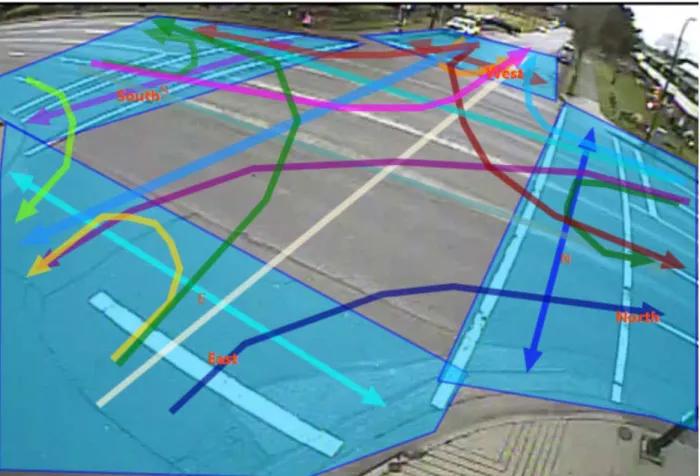
Figure 1 below shows an example of what video image processing produces. Each colored line represents a different mode of travel and direction of travel through an