MULTIFACETED FACADE TEXTURES
FOR 3D CITY MODELS
Jurgen BOGDAHN
Multifaceted Fagade Textures
for 3D City Models
Jurgen Bogdahn
School of the Built Environment
Salford University
Submitted in Partial Fulfillment of the Requirements of the Degree of
Doctor of Philosophy (PhD)
Contents
List of Figures vii
Listings x
Acknowledgements xi
Declaration xii
Glossary xiii
Abstract xv
1 Introduction 1
1.1 Research Problem ... ... 1
1.2 Contribution to Knowledge ... 3
1.3 Aim & Objectives ... 4
1.4 Structure of the Thesis ... 7
2 Background & Motivation 10 2.1 Relevant Work ... 11
2.1.1 Use of 3D city models ... 11
2.1.2 Data Acquisition ... ... ... 16
2.1.3 Procedural Modelling ... 17
2.2 Background ... 19
2.2.1 Six Types of 3D City Models . ... 20
2.2.2 Multipurpose Model Management ... 23
2.2.3 Management Systems for Urban Models ... 25
2.2.4 Spatial Data Infrastructures ... 28
2.3 Motivation ... 31
2.3.1 Textures in current 3D City Models ... 31
CONTENTS
2.3.3 3D City Models & Map Illustration ... 38
2.3.3.1 2D Map Rendering ... 40
2.3.3.2 2.5D Map Rendering ... 41
2.3.3.3 3D Map Rendering . . ... 42
2.3.3.4 Extension of Map-Space ... 44
2.3.4 Level of Detail and Level of Realism ... 45
2.3.5 Additional Information in Fagade Textures ... 48
2.4 Summary ... 50
3 Methodology 52 3.1 Constructive Research ... 52
3.1.1 Six Stages of Constructive Research ... 54
3.2 Realizing the Stages of the Constructive Approach ... 55
3.3 Literature Review ... ... 57
3.4 Proof of Concept by Prototyping . ... 60
3.5 Validation by Case Study ... 62
3.6 Summary . . ... 66
4 Texture Content Model 68 4.1 The Image ... ... 70
4.2 Video ... 72
4.3 The Texture ... 74
4.4 Data Sources for Textures ... 77
4.5 Texture Atlas ... 79
4.6 Modelling of Null-Texture Content ... 81
4.6.1 Zones ... 81
4.6.2 Layer ... 82
4.6.2.1 Description The Pulse Function . ... 85
4.6.2.2 Alternative Descriptions ... 90
4.6.2.3 Operations ... 91
4.6.3 The Real-Time Layer ... 93
CONTENTS
4.6.3.2 The Player Components ... 97
4.6.3.3 Summary ... 99
4.6.4 Mapping of Information to Zones/Real-time layer ... 99
4.6.4.1 Image to Zone ... 99
4.6.4.2 Measurement Set / Attributes to Zone ... 101
4.6.4.3 Real-Time Content to Real-time Layer . ... 101
4.7 The Reconstruction Implementation ... 102
4.8 Integration into Spatial Data Infrastructures .... ... 104
4.8.1 Flexible Integration into Client-Server Process Chains ... 105
4.8.2 Scenario 1: Server Side Texture reconstruction ... 105
4.8.3 Scenario 2: Client Side Reconstruction and Processing ... 107
4.8.4 Scenario 3: Pre-processing for Clients with Special Requirements ... 109
4.9 Discussion ... 112
4.9.1 Pulse Function Approach ... 112
4.9.2 A Similar Approach for Thematic Visualization ... 113
4.9.3 Real-Time Layer ... 115
4.9.4 Integration into (3D-) SDIs ... 116
5 Proof of Concept 117 5.1 The Rendering Pipeline ... ... 118
5.2 The Programmable Elements of the Rendering Pipeline ... 121
5.3 Data Management and 3D Viewer Integration ... 124
5.4 The Pre-Processing Step implemented as Utility Functions ... 128
5.5 Data Texture ... 129
5.6 The Texture Atlas ... 134
5.7 The Rendering Concept ... 135
5.7.1 The Construction of Fagade Texture Content ... 136
5.7.2 The Real-Time Content ... 141
5.7.3 Video ... ... 142
CONTENTS
5.7.5 Rendering Real-Time Data embedded in the Fagade Texture . . 145
5.8 Summary ... ... 148
5.8.1 Performance ... 149
5.8.2 Scalability ... 151
5.8.3 Real-Time Content .... ... . ... 153
6 Pedestrian Navigation using 3D City Models - a Case-Study 154 6.1 Concepts of Navigation - Cars compared to Pedestrians ... 156
6.2 Landmarks ... 161
6.3 The MoNaSD Project ... 163
6.3.1 The MoNaSD Spatial Data Infrastructure . ... 165
6.3.2 Storage Efficient Synthetic Textures ... 167
6.3.3 The Smartphone Client Prototype ... 169
6.3.4 Summary . . ... 169
6.4 Visualization of Buildings and Landmarks for Pedestrian Navigation . . 170
6.4.1 Level of Realism ... 170
6.4.2 Navigation Hints ... 174
6.4.3 Shop Signs . ... ... ... 179
6.4.4 Link to Indoor Navigation ... ... 180
6.5 Summary ... ... 182
7 Conclusions & Future Work 186 7.1 Conclusions ... ... ... ... 186
7.1.1 Objective 1: Flexible Description ... 186
7.1.2 Objective 2: Adjustability and additional Information ... 188
7.1.3 Objectives: Real-time Content Changes ... 189
7.1.4 Objective 4: 3D-SDI Integration ... 191
7.1.5 Objectives: Evaluation of the presented Approach ... 193
7.1.6 Summary ... ... . . 194
7.2 Future Work ... 195
7.2.1 Layer/Zone Model ... 195
CONTENTS
7.2.3 Real-Time Layer ... ... 197
7.2.4 3D Spatial Data Infrastructures ... 198
7.2.5 Pedestrian Navigation ... 198
List of Figures
1.1 The Thesis Structure ... 8
2.1 Example for 3D building models in a Nav-System ... 13
2.2 Visualization of air pollution ... 14
2.3 Visualization of simulation scenarios ... 15
2.4 Obligue imagery for generating 3D city models ... 17
2.5 Fagade grammars ... 18
2.6 Type-3 Model ... 22
2.7 Type-6 Model ... 23
2.8 CAT3D as basis for OGC Services ... 28
2.9 Schema of Surface Properties ... 33
2.10 Simple World Map ... 40
2.11 2.5D-Surfaces as Map-Space ... 41
2.12 3D Map with Tree-Icons .... ... 42
2.13 3D Map-Terrain with Building-Icons ... 43
2.14 Extension of Map-Space ... 44
2.15 CityGML LoD concept ... ... . 46
3.1 Constructive Research . ... ... 53
3.2 Research Stages ... 56
4.1 Image coordinate system ... 71
4.2 Texture Mapping ... 76
4.3 Null-Texture Concept ... 77
4.4 Texture Atlas Concept ... 80
4.5 Using BSP to create texture atlas ... ... 81
4.6 Defining a Zone ... 82
4.7 The Layer Concept ... 84
LIST OF FIGURES
4.9 Pulse functions overlap ... ... 87
4.10 Multiple use of Pulses ... 88
4.11 False Zones ... 89
4.12 Painter's Algorithm ... 92
4.13 Thermal Image Content vs Fagade Structure ... 94
4.14 Real-Time Layer Concept ... 96
4.15 Real-Time Layer Implementation Concept ... 98
4.16 Possible reconstruction levels for texture content ... 106
4.17 Portrayal W3DS ... 107
4.18 Thin Client using Shader on GPU .... ... 109
4.19 Fat Client using Shader on GPU ... 111
4.20 Surface Properties Tool ... 114
5.1 OpenGL Operations ... . 119
5.2 OpenGL Programmable Processors ... 122
5.3 Fragment processor inputs and outputs ... 123
5.4 The CAT3D Architecture ... 125
5.5 The CAT3D Data Model ... 126
5.6 The Extended Texture Model ... 127
5.7 Layer encoding into Data Texture ... ... 130
5.8 Pulse Rows in DataTexture ... 132
5.9 Bounding Box for Zones in one Layer. ... 137
5.10 Two level rendering ... 140
5.11 Video-Player implementation ... 143
5.12 Pachube-Player implementation . ... 145
5.13 Real-Time Layer Rendering ... 147
5.14 Prototype Rendering Performance Measurement ... 149
6.1 Example for decision support in car navigation systems ... 157
6.2 Lines to Approximate Square ... 158
6.3 Kunstmuseum Stuttgart ... 162
LIST OF FIGURES
6.5 Emphasizing landmarks in 3D Scene ... 172
6.6 Sketch Rendering ... 173
6.7 The Pre-verbal Message ... 175
6.8 Visual Hints for Landmarks ... 176
6.9 Navigation Hints in Fagade ... 177
6.10 Bubbles for linking nav-instruction to landmark ... 178
6.11 Highlights for fagade elements ... 181
6.12 Navigation hint for correct entrance and floor of a building ... 183
Listings
Acknowledgements
First and foremost I would like to thank my supervisor Mr. Andy Hamilton, head of the
Virtual Planning Group at Salford University and my second supervisor Prof. Dr. Volker
Coors from HFT Stuttgart University of Applied Sciences. Both of my supervisors
always supported me during this PhD research with invaluable advice. I want to thank
both of them for their continuous efforts to guide me through this process and I am
grateful for their patience and positive attitude, which provided a very fruitful working
environment.
I would also like to thank my colleagues in the projects MoNaSD, VEPs and CityNet for
their support. I always enjoyed discussions, meetings, coffee breaks and all the other
occasions for a little chat. I learned a lot of things in these very interesting projects, not
only in terms of my research but also for life.
I would also like to thank all the colleagues at HFT Stuttgart for their support and the
never ending interest in my work. Very special thanks to the staff at the School of the
Built Environment at Salford University, who helped me with all administrative questions
and who were very supportive throughout the years.
Finally I would like to thank my family for their encouragement and support. And I am
especially grateful to have my girlfriend Michaela by my side, who, as always, believed
Declaration
I herewith declare that I have produced this thesis without the prohibited assistance of
third parties and without making use of aids other than those specified; notions taken
over directly or indirectly from other sources have been identified as such. This work
has not previously been presented in identical or similar form to any other UK or foreign
examination board.
Glossary
ADE Application Domain Extension API Application Programming Interface AR Action Research
Bbox Bounding Box
BRep Boundary Representation BSPTree Binary Space Partitioning Tree CAD Computer Aided Design
CAT3D CityModel Administration Toolkit 3D CityGML City Geography Markup Language dpi Dots per inch
DSM Digital Surface Model DIM Digital Terrain Model EDA Exploratory Data Analysis FBO Frame Buffer Object GIS Geo-lnformation System GLSL OpenGL Shading Language GML Geography Markup Language GPU Graphics Processing Unit HCI Human Computer Interaction JMF Java Media Framework KML Keyhole Markup Language L-System Lindenmayer-System LIDAR Light Detection And Ranging LoD Level of Detail
LoR Level of Realism Ipi lines per inch
MoNaSD Mobile Pedestrian Navigation in 3D (project) NPR Non-Photorealistic Rendering
Glossary_______________________
PV Photovoltaic
SDI Spatial Data Infrastructure SWT Standard Widget Toolkit TBO Texture Buffer Object
TIN Triangulated Irregular Network
VEPs Virtual Environmental Planning System (Project) ViSC Visualization in Scientific Computing
VR Virtual Reality
VRML Virtual Reality Modelling Language W3DS Web 3D Service
Abstract
Three-dimensional digital representations of cities are widely used today, from urban
planning to navigation systems, emergency response and to energy and flood simu-
lations. Many of these scenarios can be served by one multipurpose 3D city model
that has the semantic and attribute information depth that is required (besides the ge-
ometrical detail). These multipurpose models do not only represent the geometrical
properties and textures and materials, which would be sufficient for pure visualization
of the urban space, they also model semantic entities like walls, roofs, ground, etc. And
all these parts , as well as the buildings, as specific, identifiable entities, can be linked
to additional information and data sets from other sources.
However, although these models have the required information-richness and can be
used beyond pure visualization, one part of these models is still treated the same way
as for pure visualization models: the textures. Textures in most of today's city models
are still a tool to enhance the photo-realistic appearance. The primary task of the
textures is still to add the 'naturalistic' elements that are not modelled in geometry.
These elements are mainly located in the fagades, namely windows, doors, signs, fire
escapes and many more.
The presented work investigates how textures can be used for information visualization,
which is more useful for the aforementioned multipurpose city models. A new texture
concept is presented that is based on flexible content, which is managed in layers. In
this way it is possible to adapt the appearance of buildings (especially fagades) to the
actual scenario. The concept also allows the integration of additional information into
the fagade, enhancing the 3D city model. In this way it is possible to generate scenario
Chapter 1
Introduction
1.1
Research Problem
In recent years many new applications for digital three-dimensional urban models have
appeared. Many cities have a digital counterpart nowadays either modelled by private
companies or by municipalities themselves. Very often these 3D city models were
built for urban planning purposes and have the task to represent the urban space in a
(photo-) realistic way to assess newly planned buildings in the existing spatial context.
These models are more or less built from a computer graphics perspective, which
intends to build an indistinguishable digital model of the real world.
However, over time more and more focus has been laid on 3D urban data and 3D visu-
alization in the GIS (Geo-lnformation System) field as well. In this world a 3D city model
is not only a graphical representation (a 'collection of triangles and textures' that rep-
resents the form of urban space) it also carries semantic information. In GIS features
are defined, which can be identified and linked to other data. This 'GIS perspective'
on 3D urban models created a further type of city models with different intensions.
Photo-realistic representation is still a scenario, which these models want to serve,
but in addition they also address issues of (visual) analysis, information modelling and
information creation as well as other similarly related aims. These additional aims be-
yond realistic visualization turn these models into 3D geo-data models. This becomes
very obvious when looking at the CityGML standard defined by the Open Geospatial
1. INTRODUCTION
structure includes much more information than necessary for pure visualization pur-
poses. Hence, the intension of the model is to serve more than this single scenario.
This intension opened the way into a new research field on its own, which includes
aspects of various related disciplines, like computer graphics, GIS, geovisualization,
etc. The city models that are under investigation in this field are multipurpose data sets
and can be used for many different applications ranging from urban planning, disas-
ter and emergency response to navigation systems and simulation tools (e.g. energy
consumption or photovoltaic potential).
However, looking at these multipurpose 3D city models in terms of textures not much
has changed in comparison to models for photo-realistic visualization. For the graph-
ical models textures were and are still used in order to enhance the photo-realistic
appearance of the model. The textures do normally apply a certain material to a sur-
face or they add elements visually, which are not modelled in geometry. Especially
fagade textures have the purpose to add details that are not present in 3D city models
geometrically. Windows, doors, signs, ledges and other fagade elements are normally
not modelled in geometry and are visually added by applying a photo-texture. And
this is also true for today's multipurpose models. As the geometrical acquisition and
the modelling of fagade details is too expensive and time consuming textures are still
used to add these elements in order to achieve a photo-realistic coherence with the
real world, although photo-realistic visualization is only one purpose of these models
among many others.
This is why this work is going to investigate how textures can be used in additional
ways to realistic visualization. As the purpose of 3D city models is not only the realistic
representation of urban space other illustration types need to be supported as well.
Like in a thematic map, not representing spatial information in a photo-realistic way,
urban objects might represent thematic information on their surface. Therefore this
work investigates how the texture content model needs to be designed to better serve
1. INTRODUCTION
1.2 Contribution to Knowledge
As already mentioned in the previous section there are city models, which are cre-
ated as multipurpose semantic information spaces rather than graphical visualization
models. This difference in purpose also demands other ways of visualization and il-
lustration of multipurpose models. They are not only a 'perfect visual copy' of the real
world that can be freely navigated and observed from different perspectives, e.g. for
urban planning purposes. Models are of an information space nowadays. They consist
of identifiable objects, which can be linked to an almost unlimited number of external
data sets, which could be visualized in specific ways in order to analyse urban phenom-
ena. Models can also be used to for simulations or can be integrated into applications
like navigation support systems. In many applications city models act as an integral
part of the problem solving process and not only as visual background information. It
is quite obvious that the intension of 3D city models, when they are modelled in ways
like CityGML defines, has grown from pure photo-realistic representation to multiple
purposes in different scenarios. This requires a different visual appearance for each
specific use-case.
However, this work addresses an element of 3D city models, which has not adapted
to the aforementioned changes. Textures are mainly used to apply the real-world
(fagade-) image to the geometry of the model in order to enhance its realistic ap-
pearance. Textures are used to hold image information, which represents one fixed
representation of the fagade/building at a given point in time (when the picture was
taken). For today's 3D city models a texture is the 'container' for an image, which in
most cases shows the real-world representation of the fagade. This is still the same
purpose as for purely visually oriented models. But this concept is limiting in regards
to today's multipurpose city models.
Therefore this work defines a new model for (fagade-) texture content. This new model
rear-1. INTRODUCTION
ranged for specific purposes. The content is sub-divided into zones and layers, which
allow adding further information into the texture content mixing it with realistic elements
if necessary. This new way of texture content definition makes it possible to generate
thematic map-like textures, which integrate different information into one visual repre-
sentation. In this way the presented work helps to see textures of urban objects not only
as a container for static real-world images but as a channel for flexible and adjustable
content in order to serve a multitude of visualization needs.
1.3 Aim & Objectives
In the previous section the standard use of textures was identified as limiting in terms of
3D city models and a more flexible solution is needed for today's multipurpose models.
It is necessary to have a closer look at the concept of texture content, especially in
regards to emerging hardware capabilities and new possibilities to directly influence
the rendering process. Therefore the overall aim of this work can be formulated as:
Determine how fagade textures can contribute to information visualization for
multipurpose, semantic 3D city models.
This aim concentrates on the texture content as such and how it can be changed into
a flexible and adaptable channel for various types of information and how different city
model representations can be supported. In addition this work also looks at issues of
3D spatial data infrastructures and the possibility to integrate a new texture concept
and its capabilities into this context. This is a necessary step as multipurpose 3D city
models are often part of this kind of environment and are often integrated into SDI
(Spatial Data Infrastructure) processes and workflows. Furthermore this work also
evaluates the capabilities of the new concept in a case-study in order to find out how
1. INTRODUCTION
Objective 1: Find a way to describe the content of (fagade-) textures that allows the flexible representation and combination of different content as well as the integration of additional (non-photorealistic) information.
This objective describes the need to flexibilize the texture content. Normally a photo image is used as the fagade texture, which consists of one fixed representation of the fagade at a specific point in time (when the photo was taken). For multipurpose models there needs to be a multipurpose visual representation as well. Therefore it is necessary to define the texture content according to specific use-cases and scenario dependent requirements. Therefore a texture content concept needs to be found that can add specific content and can exclude other content if the scenario requires this. Another aspect of this flexibility is that scenarios might require additional content to be added besides the photo-realistic elements of the fagade. As the multipurpose models consist of identifiable objects that are often linked to significant amount of additional attribute data, the need for visualizing these attributes is very immanent in specific use-cases.
Objective 2: Define concepts in order to adjust the ratio of realism as well as the ratio between realistic elements and the integrated additional information
1. INTRODUCTION
Objective 3: Implement a suitable prototype in order to test the flexibility of
(fagade-) texture content and its appearance in regards to real-time contextual events.
In regards to flexibility and the ability to use the new texture concept in analysis scenar-
ios or for use-cases where context dependent changes of the model's appearance are
required, it would be necessary that the texture content can change in real time. Real-
time in this context is defined by an acceptable response time from the point when the
new appearance was requested to the point when the change in the texture content is
finished. When the response time can be held relatively low this would allow interactive
changes of illustrations. In combination with the first two objectives formulated above
this would mean that switching between different fagade representations and different
sets of information/data can be realized for the user in a similar way to a GIS. This
would allow using the texture content model for knowledge retrieval and analysis of
urban space and support the multipurpose nature of 3D city models in this respect.
Objective 4: Investigate how the new texture model can be integrated into 3D- SDIs and how services can address the absence of certain client capabilities.
As multipurpose 3D city models are used in various different scenarios they are nor-
mally managed in a special way. Very often they are stored in spatial databases and
managed by a dedicated system, which provides (web-) interfaces for clients to retrieve
the suitable model for a specific purpose. Furthermore these dedicated management
systems are often integrated into SDIs where the 3D model can be merged with other
data on request and be integrated into scenario related workflows. Because multipur-
pose 3D city models are often used in a SDI environment it needs to be investigated
how the new texture concept can be integrated into this environment. Aspects on
client/server capabilities and related distribution of workload need to be addressed.
The texture content model should be able to be used in a flexible way and be able to
1. INTRODUCTION
Objective 5: Evaluate the capabilities of the new texture content model in a spe- cific use-case.
The newly developed model for describing (fagade-) texture content is evaluated for a
specific use-case. It needs to be found out how the new capabilities and the flexibility
of the concept can support certain scenarios in which 3D city models are used. The
work presents a case-study that evaluates how flexible texture content can be used in
the case-study scenario. By generalising the findings of the case-study, this work tries
to estimate the benefits for the whole field of digital 3D urban models.
1.4 Structure of the Thesis
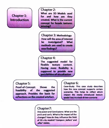
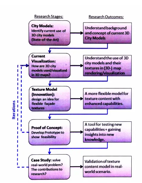
The remainder of this thesis is organized in the following way (see figure 1.1).
Chapter 2 shows the wider context of the research and provides a selection of relevant
work. The chapter describes the background on how 3D city models are produced and
in which scenarios they are used. Different types of models and variations in their
structure are also presented based on the work of Stadler and Kolbe (2007). From this
description of the background the chapter develops the motivation for this research and
the rationale for investigating a new texture content model for 3D city models.
Chapter 3 presents the methodology used for the presented work. The chapter de-
scribes the process of constructive research and in which way it aims to generate new
knowledge. In a second part this chapter shows which research methods are actu-
ally used in this work to perform the different stages of constructive research, namely
literature review, prototyping and case-study.
Chapter 4 describes the new model for (fagade-) texture content that is going to be
used to arrange information appropriately for flexible visualization of city models. The
chapter develops the new texture content model based on basic elements (image,
1. INTRODUCTION
Chapter 1:
Introduction
Chapter 2:
What are 3D Models used for and how are they created. What is the current concept for facade textures
ChapterS: Methodology
How will the area of interest be investigated? What methods are used to create new findings?
Chapter 4:
The suggested model for flexible texture content. Having more flexibility is supposed to provide new ^possibilities of visualization ^
ChapterS:
Proof-of-Concept: Shows the feasibility of the suggested approach. Provides the basis for reflections on the created artefact.
Chapter 6:
Case-Study: This case study describes how the new concept supports certain scenarios. This helps to reflect which impact the newly introduced texture model has in a task-driven scenario j
Chapter?:
[image:24.553.42.506.116.661.2]Discussion and Conclusions: What are the pro'sand con's. What is the impact of the changes? How do they influence the field of 3D city models? Compare .before' and .after'-states.
1. INTRODUCTION
Realism, Real-Time Layer) in order to manage the content. This chapter also discusses
issues about how to integrate the new content approach into the environment in which
3D city models often exist. This integration into (3D-) SDIs is a very important part that
the texture content model needs to achieve. Hence, the use of the texture model in
client-server scenarios is discussed in this chapter as well.
Chapter 5 presents the prototype that is implemented in order to prove the feasibility of
the new texture content model. The second aspect that the prototype should prove is
the ability to change the texture content in real-time according to user input or changes
triggered by the system/application during rendering. This issue is important when 3D
models are used in scenarios where the model appearance needs to change during
the visualization and the model is not loaded in a specific representation that does not
change while the model is in use.
Chapter 6 presents a case-study in which the new texture content model is assessed
and it is expected to be of mutual benefit for the task-solving process. Some aspects of
the new content model are compared to the traditional texturing approach and benefits
of the new approach are discussed. The chapter intends to show the applicability of
the texture content model and to outline extended visualization capabilities, which are
regarded as contributions to existing knowledge and concepts.
Chapter 7 provides conclusions and an outlook on future work. This chapter revisits
the objectives formulated in chapter 1.3 and sums up the results in regards to these
objectives. The second part of the chapter formulates starting points for future research
Chapter 2
Background & Motivation
This chapter is going to provide an overview of the current state-of-the-art and the context in which this research is conducted. It starts with relevant work in the field of 3D city models in order to provide an overview of the wider research field and it also includes a section discussing different data acquisition methods. The variety of acquisition and modelling approaches reflects the different types of models that exist as well as the aspect that models are captured and built differently for different purposes. A further part of the context summary is going to present the definition for six types of models and their differences, how they are managed and integrated into spatial data infrastructures.
The state-of-the-art and relevant work in this chapter provides the current situation of 3D city modelling and visualization and shows the existing situation in this field. Besides demonstrating and clarifying the context of the research it also describes the current situation to which the results of the work need to be compared (see chapter 3). In the sphere of differences between current state-of-the-art and the newly developed model for texture content (presented in chapter 4) new findings are expected to be found and to be evaluated.
2. BACKGROUND & MOTIVATION
Hence, the chapter acts as the context of the work and provides a basis for validating
the result of the work on the one hand. On the other hand it uses the current situation,
more precisely the lack in current knowledge, to explain the rationale and motivation of
the work.
2.1
Relevant Work
In this part examples of relevant work are presented. The section provides an overview
on the state-of-the-art in 3D city modelling as well as a selection of use cases, in which
these models are used. Besides the different forms of use this part of the work also
includes state-of-the-art data acquisition methods and a section on procedural model
generation based on grammars and specialized algorithms. Knowing the current state
of 3D city models and their purpose provides the context in which this research is
undertaken. Therefore it describes the 'status quo' of the research field to which the
results of this work is going to be compared to. Hence, a profound knowledge about the
relevant work and the current concept of 3D city models is essential. The use-cases
and ways of data capture presented in this section reflect this existing concept.
2.1.1
Use of 3D city models
Three dimensional urban models play a growing role not only in terms of visualization
purposes but also as well regarded data sets in CIS and related disciplines. This 'is
illustrated by some state-of-the-art cases, worldwide, suggesting that rapid changes
are taking place in the ways such visualisations are being developed. We note devel-
opments in remotely sensed survey and in the development of 3D models integral to
spatial databases as reflected in G/S'(Shiode, 2001). They are useful in many scenar-
ios and can provide an extra benefit when integrated into other applications. Shiode
infrastruc-2. BACKGROUND & MOTIVATION
ture and facility services, (3) commercial sector and marketing, and (4) promotion and
learning of information on cities'. In specific scenarios it appears beneficial to have a
visual/photo-realistic representation of the city (planning and design) in order to make
design decisions or to learn about the geographical layout of the city ((4) promotion
and learning of information on cities). 'Planning and detailed design reviews as well
as problems of site location, community planning and public participation all require
and are informed by 3D visualisation. The focus is upon aesthetic considerations of
landscapes as well as daylight and line-of-sight. Visual representation of environmen-
tal impact is also widely supported by 3D models' (Shiode, 2001). In other scenarios
like infrastructure and facility services it might be necessary to work with more detailed
models with a set of semantic information and attributes attached to the semantic enti-
ties. This allows performing analyses of the urban objects, etc.
When 3D models are integrated into other applications there are two ways how the
models can support the specific scenario and the application in which it is integrated.
For some scenarios the 3D model provides the context for other spatial information. In
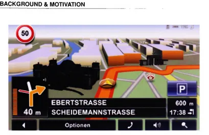
recent car navigation systems, for example, the 3D model acts as the background for
the visualized route and the direction instructions of the system (fig. 2.1). For some
scenarios the 3D model provides the context for other spatial information. In recent
car navigation systems, for example, the 3D model acts as the background for the
visualized route and the direction instructions of the system (fig. 2.1).
The process of calculating the route and providing guidance instructions as such does
not include any 3D data or is linked to the 3D model. Placing 3D building models onto
the tilted map with the route visualization should provide the context for the user to
support the self-localization and navigation process. However, there are also efforts to
integrate 3D information/the 3D model into this process directly. The project MoNaSD
(Mobile Pedestrian Navigation in 3D) (Coors and Zipf, 2007) tries to integrate 3D city
models into the pedestrian navigation process by including landmarks, building objects
2. BACKGROUND & MOTIVATION
rr*
EBERTSTRASSE
__
40 m
SCHEIDEMANNSTRASSE^
Oplionen
[image:29.553.77.486.53.318.2]600 m
17:38-Tl
Figure 2.1: Example for 3D building models in a Nav-System - An example for 3D build- ings in a car navigation system providing spatial context (from http://www.navigon.com/, copyright Navigon AG)
accordingly. Here the 3D model is tied stronger into the application and the solution of
the actual task. The landmarks for the specific route are automatically identified by an
algorithm that scans the 3D model and they are integrated into navigation instructions
(see chapter 6).
Another example is using 3D city models for simulations of environmental influences.
Floods as well as air- and noise pollution need to be based on some kind of 3D data.
Three-dimensional digital city models can be used to provide the geometrical input data
for these simulations. Kokas (2008) provides some flooding simulation results based
on his models and Czerwinski et al. (2006) provides a report on noise simulations
using 3D city models as a basis. Another example for using 3D city models as input
for simulations is presented in Strzalka et al. (2010). Here the modelled 3D buildings
are used to extract properties like volume, height, orientation and area of walls, etc.,
which are then used as one of the required inputs for an energy demand estimation
simulation. This simulation cannot only be performed for one single building but for
2. BACKGROUND & MOTIVATION
visualize simulations results and provide the spatial context for the produced output.
Other examples are the Air Pollution Map for London (www.londonair.org.uk, 2011)
(fig. 2.2) and Kokas (2008) provides some examples on flood simulation visualizations
[image:30.553.107.466.187.462.2]in his thesis for Heerbrug, Switzerland and London.
Figure 2.2: Visualization of air pollution - Air pollution overlaid onto the 3D model (LoD1; of London (from http://www.londonair.org.uk/london/asp/virtualmaps.asp)
In the field of flood simulations Schulte and Coors (2008) present an Application Do-
main Extension (ADE) in order to integrate hydrological data into the CityGML stan-
dard. In this way the 3D city model and flood data can be exchanged together in an
open data format and can also be processed together, e.g. for visualization or for
rerunning the simulation and verifying it.
A further example for using 3D city models in an application context is presented in
Knapp et al. (2007). The presented system for public participation in urban planning
uses digital 3D models of the development area in a web-based system to commu-
2. BACKGROUND & MOTIVATION
a comment, or access the comment of others, by selecting the according building di-
rectly in the 3D model. Exploring what-if scenarios is also possible by switching certain
planning proposals (modelled in 3D) on/off in the 3D scene. In this case the model
is not only a way of visualizing a planning proposal and thereby communicating in a
one-to-many fashion (municipality to citizens) but also allowing a discussion which is
a many-to-many fashion (municipality o citizens and citizen <^> citizen). In literature
one can find more scenarios in which 3D city models are used beyond pure visual-
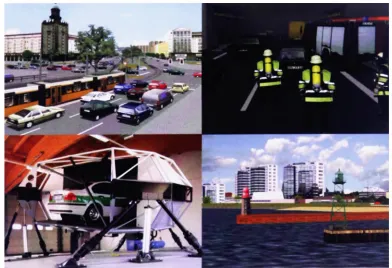
ization and to help to solve other tasks. There are examples for emergency response
(Kolbe, 2008), simulation of wave propagation ((Fabritius et al., 2008), (Schmitz and
Kobbelt, 2006)), simulation and training (Bildstein, 2005) (fig. 2.3), public safety (Qiu
et al., 2004) and the visualization of change in urban areas over time (Weber et al.,
[image:31.553.82.474.406.674.2]2009).
2. BACKGROUND & MOTIVATION
2.1.2 Data Acquisition
The 3D models for these and many other applications are generated in many differ-
ent ways, which can include various sensors and algorithms. As cities are quite large
structures and it is necessary to model a quite significant number of objects, therefore
normally sensors are used that can acquire a big amount of data in reasonably short
time (for a comprehensive summary see Hu et al. (2003)). Appropriate and intelligent
algorithms and software tools help to manage and analyse these large data sets in or-
der to extract the required information (urban objects). Another strategy is to produce
city models procedurally (e.g. Fabritius et al. (2008)) according to a specific algorithm
which can also use a set of rules that can be combined in an intelligent way. This
procedural approach will be described in detail in the next section. A quite common
approach to model buildings, vegetation and streets is based on aerial photogram-
metry. Aerial photos can be used to gather urban structures in an (semi-) automatic
way. Examples can be found in Brenner et al. (2001) giving an overview on differ-
ent modelling concepts for 3D city models. In Kokas (2008), Schwalbe et al. (2005)
and Brenner and Haala (1998) approaches for acquiring building data from aerial laser
scans (LIDAR) are described and an approach using satellite images for automatic 3D
building reconstruction can be found in Lafarge et al. (2007). A relatively new data
source for detecting and modelling the geometry and acquiring textures (fagade tex-
tures) of buildings is oblique imagery (Wang et al. (2008), Lorenz and Dollner (2006)).
Hamruni (2010) also describes an approach using oblique images to model 3D urban
buildings and fagade textures. The retrieval of fagade images is possible because not
only vertical images (nadir) are taken but oblique views are recorded as well. In the
oblique pictures the fagade structures can be better analysed and modelled.
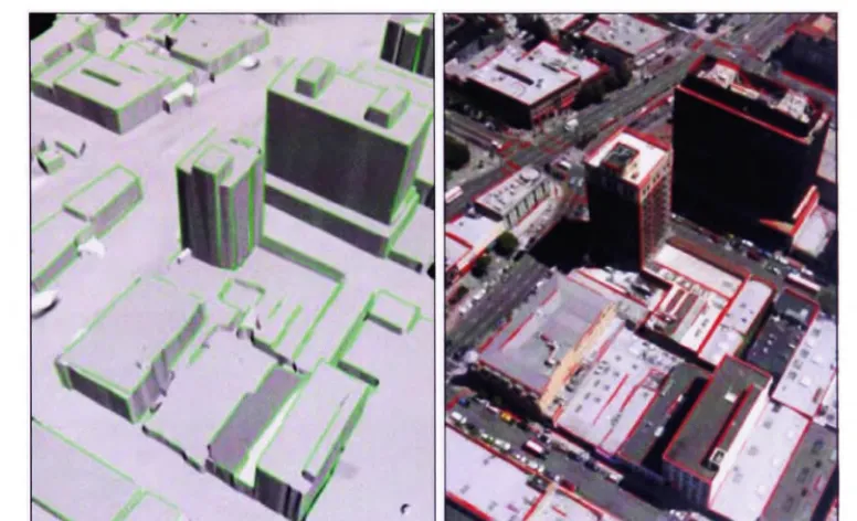
Especially the generation of fagade images and textures, respectively fagade struc-
tures, is investigated by many researchers. Different data capture methods are pre-
2. BACKGROUND & MOTIVATION
occluded areas another aspect of textures is investigated: The automatic mapping of
the image to the building's geometry (Kada et al., 2005). As the process of applying
textures manually to the building geometry is very time-consuming and expensive an
automated solution is beneficial. Besides the concepts for terrestrial images there are
also methods presented for oblique imagery (Frueh et al. (2004), Lorenz and Dollner
[image:33.553.82.470.228.464.2](2006)).
Figure 2.4: Obligue imagery for generating 3D city models - (a) Visible 3D lines of the model in green; (b) 2D lines in the image in red.(from Frueh et al. (2004))
2.1.3 Procedural Modelling
As mentioned before, the modelling process for entire cities is still time consuming
and rather expensive because it is still not fully automated. In scenarios where it
is not necessary to produce an identical copy of a real world city (or the real world
city does not exist as a reference) procedural approaches can be used to generate
buildings and other urban objects according to (user-) defined rules. Coelho et al.
(2007) presents an approach that is based on Lindenmayer-Systems (L-Systems). A
2. BACKGROUND & MOTIVATION
Finkenzeller and Schmitt (2006) and described in detail in Finkenzeller (2008). Parish
and Muller (2001) present a further concept that is based on extended L-Systems for
creating street networks and building geometry. Wonka et al. (2003) do present con-
cepts for procedural modelling for virtual cities based on what they call split grammars,
which 'draws from the work on shape grammars pioneered by Stiny' (Wonka et al.,
2003). Muller et al. (2006) consequently combined the approaches of Wonka et al.
(2003) and Parish and Muller (2001) to the CGA Shape-concept for procedural mod-
elling of even more detailed building mass models. In their paper Muller et al. (2007)
the concept is also extended on the modelling of fagades. This approach allows ex-
tracting fagade elements and rules for the fagade structure. The 'style' of the extracted
fagade grammar can then be applied to arbitrary building geometries (fig. 2.5). A more
general procedural approach for texture synthesis for wall materials can be found in
[image:34.553.81.481.412.696.2]Legakiset al. (2001).
2. BACKGROUND & MOTIVATION
Lipp et al. (2008) developed a concept for users to vary the fagade rules giving design-
ers more influence on the final appearance of the facade style. A comparable similar
approach for fagade texture construction based on real world images is presented in
Ricard et al. (2008). In contrast to Muller et al. (2007), this approach 'uses a merging of
various histograms resulting from image analysis algorithms (hough, edge and back-
ground detector) to detect the main features of a fagade' (Ricard et al., 2008) inside the
real world image. Fagade grammars are also interesting for the concept presented in
this work. For generating fagade grammars features and elements of the fagade need
to be detected and their distribution on the wall needs to be identified. This information
could also be used as the input for the texture model described in chapter 4.
Other authors also investigate fagades and try to detect and extract features inside
of fagade images. Lee and Nevatia (2004) presents a concept for automatic window
detection using 'a profile projection method, which exploits the regularity of the vertical
and horizontal window placement'. In Wang et al. (2002) another approach for fagade
structure extraction is presented. Ripperda and Brenner (2007) present a concept for
fagade reconstruction that is 'based on a formal grammar to derive a structural fagade
description in the form of a derivation tree and uses a stochastic process based on
reversible jump Markov Chain Monte Carlo (rjMCMC)'. Becker et al. (2008) describes a
method for fagade reconstruction based on terrestrial laser scan point clouds. Missing
windows that are not detected due to low data acquisition quality are inserted into the
fagade using a formal grammar that is extracted from formerly reconstructed fagades,
which act as a knowledge base.
2.2 Background
This part of the chapter is taking a closer look at the actual structure of 3D city models
and at definitions of various manifestations of actual models. Stadler and Kolbe (2007)
2. BACKGROUND & MOTIVATION
types of models can be related to different ways of data acquisition/modelling as well as
different terms of use (described in the previous sections). More sophisticated models
in terms of additional information and semantically rich data sets can be modelled
using formats like CityGML. These models can be characterized as multi-purpose data
sets as they can include much more information about urban space/urban objects than
necessary for pure visualization purposes. Therefore these models are also managed
in a different way in order to provide access to information included in the data models.
The relevant infrastructure and concepts for model management are also presented in
this section to show the (technical) environment in which these 3D city models exist.
2.2.1
Six Types of 3D City Models
As one can see in chapter 2.1, 3D city models can be created in very different ways for
very different purposes. Therefore the structure as well as the amount of (semantic)
information that is included into these models can differ quite significantly. There are
different types of city models and not all of them can be used for all purposes. Stadler
and Kolbe (2007) provide a profound discussion on different 3D city model manifesta-
tions and define six types of models. In their paper they discuss the two characteristics
of 3D city models, the geometric and the semantic model, based on the CityGML stan-
dard (OGC, 2008a) and show the interrelation and detail in which the two parts are
represented for the six model types. This thesis follows their definition of the six model
types and refers to them using the same numbers (type-1 to type-6 models).
The six cases from Stadler and Kolbe (2007) are:
Case 1: Only geometry, no semantics
Case 2: Only semantics, but no geometry
2. BACKGROUND & MOTIVATION
Case 5: Complex objects with unstructured geometry
Case 6: Complex objects with structured geometry
The distinct cases (1-6) defined by Stadler and Kolbe (2007) depend on the two afore-
mentioned characteristics of 3D city models: geometry and semantics. The authors
refer to ISO 19109 and the GML3 standard (Geography Markup Language) for the
CityGML model, which describes building objects. Basically all classes in CityGML's
semantic model are 'derived from the basic class feature, defined in ISO 19109 and
GML3' (Stadler and Kolbe, 2007). For the geometrical model the CityGML standard
uses 'objects of the GML3's geometry model which is based on the standard ISO
19107 'Spatial Schema' (Herring, 2001), representing 3D geometry according to the
well-known Boundary Representation (BRep, Foley et. al, 1995). CityGML actually
uses only a subset of the GML3 geometry package' (Stadler and Kolbe, 2007).
For example, a type-3 model (fig. 2.6) defines a simple building object in the semantic
model and unstructured geometric instances to form the shape of the building. Type-1
models do not even have a semantic entity for 'urban objects'. These models exist only
of unstructured geometry that models the visual appearance of urban space. Models of
this type are 'based on 3D graphics formats like VRML, X3D, KML, U3D or legacy CAD
formats' (Stadler and Kolbe, 2007). However, introducing a minimum of conventions it
is possible to generate type-1 models that can easily be converted into type-3 models.
In VRML (Virtual Reality Modelling Language) (WebSD Consortium, 2003) for example,
it would be possible to define each semantic building as a group node named after the
ID of the actual building (as a link to further non-visual data). This group node would
act as a container for the formerly unstructured geometry. Hence, it is possible to a
certain extent to transform models from one type to another.
Besides type-6 models, which will be described later in this section, type-3 models are
in focus in this work, because they provide sufficient semantic information to fulfil the
2. BACKGROUND & MOTIVATION
Building Semantics Geometry
Figure 2.6: Type-3 Model - Simple object with unstructured geometry (Case 3)(Stadler and Kolbe, 2007)
models it is possible to identify semantic objects (and their type). It is possible to
identify single buildings in the data set and retrieve an identifier, which allows accessing
any non-visual data that is linked to the object, e.g. building attributes like year of
construction. Therefore, these models can be used in information systems where the
city model acts as a freely navigable 3-dimensional interface to further data linked to
the 3D representation.
For example, in the EU-project 'VEPs' (Knapp et al., 2007), which investigated the use
of 3D city models in public participation in urban planning, it is possible to navigate
a 3D scene of existing and planned objects. It is possible for users to get additional
information about objects in the scene and to leave comments (linked to buildings) by
choosing the building in the 3D scene. In this case the visual aspect of the model
was important, but also the semantic entity that needs to be present in order to link
data/comments or access additional information. Semantic modelling of walls, roof or
building floors, etc. was not necessary because the scenario did not require them in
this case.
The models that this work investigates in detail are the type-6 models (fig. 2.7). This
type of model provides a very high 'spatio-semantic coherence' (Stadler and Kolbe,
2007), models semantic and geometry in the same detail and also links the two el-
ements of the 3D model. Walls, roofs and ground elements of the building hull, for
example, are modelled in semantics and a separate geometry is associated with them.
2. BACKGROUND & MOTIVATION
ditional attributes can be assigned to the semantic entities and an information-rich, meaningful model can be created. In contrast to type-3 models even more scenarios can be served as more information about the objects and their structure is present. Type-6 models can therefore be regarded as multipurpose models, especially in con- trast to type-1 pure visualization models. The CityGML data format is a well-known format that can describe type-3 as well as type-6 city models 1 . Many examples can be found in literature for CityGML use cases supporting the multipurpose nature of type-6 models.
Figure 2.7: Type-6 Model - Complex object with fully coherent spatio-semantic structure (Case 6) (Stadler and Kolbe, 2007)
2.2.2 Multipurpose Model Management
Multipurpose, semantically rich models demand for better management systems, which can provide specific subsets of the model as well as scenario specific information. Having this kind of management systems at hand appears to be crucial as the models are supposed to be used in different scenarios. Therefore it is necessary to be able to query exactly the 'form' of model that is required in the specific scenario.
The previous section outlined that type-6 models have a high coherence between the semantic and the geometrical part of the model and that these models can be also
2. BACKGROUND & MOTIVATION
linked to various external data sets. This can be regarded as one of the major rea-
sons for the multipurpose nature of type-6 models, they can serve various scenarios
because they provide more information about the semantics and structure of urban
space and they can be linked to scenario specific information on data level (not only
visually superimposed).
However, as there is not only one specific use-case into which the model is perma-
nently integrated, there are probably many different 'user'-systems, which have very
specific requirements and also different hardware capabilities. Furthermore, it is ex-
tremely unlikely that arbitrary clients in various scenarios work with exact the same
part of the model or with the model as a whole. Moreover, it is necessary to provide
different spatial parts of the model for a specific use-case, most probably in a specific
style or an adequate Level of Detail (LoD) (see chapter 2.3.4).
With all these requirements in mind (and there are certainly several more) it is obvi-
ous that this flexibility can hardly be achieved by a file-base city model. Especially
when separate (file-based) models are used for separate use-cases, e.g. in specific
departments of a municipality there is a danger of inconsistency, storage of the same
information in several places (inefficient) and possibly the establishment of 'information
islands' that produce considerable problems when need to be merged with 'outside'
data or models.
A possible solution for managing the models more efficiently and in a more flexible way
can be found in the GIS world. Geographic data is very often managed in dedicated
Gl systems that very often make use of spatially enabled database systems. A similar
approach can be observed in the case of multipurpose 3D city models, which show the
characteristics of 3D geo-data. These models are also managed in spatial database
systems and administered by dedicated 3D model management systems (e.g. J. Haist
2. BACKGROUND & MOTIVATION
2.2.3 Management Systems for Urban Models
As outlined in the previous section it is very complicated to serve multipurpose models
by a file-based approach and therefore dedicated systems are in use to provide models
in diverse scenarios. This section looks at the 3D management systems in more detail
and on the requirements they have to fulfil. It will also look at the CAT3D framework
(CityModel Administration Toolkit) that was developed by the author of this thesis and
extended in term of this work. By using this framework as an example possible imple-
mentation options for service processes are discussed to show how the flexible output
of these systems can be achieved.
The management systems that this work refers to need to serve different outputs based
on one centralized model (not based on separate models for each scenario) in:
the right size (spatial extent as well as data size)
the right data format
the right type (1-6)
with the right information density
in the appropriate visual representation
The size of the model depends on two aspects: 1) for specific scenarios it is not nec-
essary to use the whole 3D model. The application scenario only focuses on a specific
quarter or the area along a certain route. Here size refers to the spatial extent and is
scenario-driven. In some cases the streaming of small portions of the model is also
part of the scenario. 2) Specific client hardware can only handle small amounts of data
(e.g. a mobile device) because of their hardware configuration or limits in the trans-
mission of data (wireless networks, mobile phone networks). In this case the model
should be small in terms of data size. This refers to the extent of the model but also
to information density or the LoD. This aspect is influenced by hardware requirements,
2. BACKGROUND & MOTIVATION
The correct data format is a quite obvious requirement as different client platforms
usually work on different data formats. This format is also linked to the way the model
is used on client side. For visualization data formats like VRML (Web3D Consortium,
2003) are used. When transmitting data to a remote information system (e.g. a CIS
or another application server in a SDI) the full range of information is needed and a
format like CityGML would be preferred.
Aspects like information density and suitable visualization are more scenario-driven
as certain use-cases do not require the full information that is present in the model. The
system itself and the implemented interfaces should allow filtering content accordingly.
But not only the capabilities of the middle-tier and the interfaces are important in this
aspect, the data model as such needs to be in a form that allows combining informa-
tion streams and not only represent pre-defined, fixed representation of one type of
information. In terms of visualization not only the standard representation of photo-
realism might be required by the client, but a combination of information sets to solve
specific tasks. In the field of geovisualization this is regarded as very important for
knowledge construction and information retrieval (Dykes et al., 2005). Interfaces and
the management system should support these capabilities in order to allow multiple
visual representations of the 3D city models.
In order to fulfil these requirements and flexibly provide output for scenario-driven
mash-ups of SDI services the 3D city model management system needs to be im-
plemented in a flexible way and to handle most diverse requests and serve various
information requirements. Systems like the City Server (J. Haist, 2005) provide this
kind of flexibility and the required functionality. Another system that is developed by
the author of this thesis can also act as a centralized 3D model repository. The CAT3D
framework provides functionality for managing 3D city models and serves them to other
systems through the OGC WebSD Service interface (W3DS). The framework acts as
a basis for developing the solutions presented in this work and to assess SDI related
2. BACKGROUND & MOTIVATION
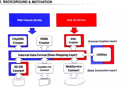
that groups modules in several logical layers. The general architecture and description
of CAT3D can be found in fig. 2.8 (grey boxes). The framework is built of three general
layers: Data Connection, Data Mapping and Format Creation. The Data Connection
layer symbolizes modules that establish a connection to a data source and translate the
external information into the internal data representation (Data Mapping Layer). Here
the information can be integrated with data from other sources or transformed (e.g.
coordinate reference system). The translation from the internal representation into a
specific output format is done by one of the modules in the Format Creation Layer.
Here the required information is read from the internal representation and translated
into an output format requested by the client application through one of the service
interfaces.
It can also be seen in figure 2.8 that it is not only possible to support one specific
data service interface. It is possible to implement a W3DS (red), for example, that
provides 3D scene graphs for rendering (e.g. type-1 or type-3 models). However,
it is also possible to implement a Web Feature Service (blue) interface (WFS) that
provides CityGML output, which includes the full type-6 model with all of its semantics
and attributes in addition to the geometry. The two interfaces on top of the 3D data
management system ensure the aforementioned requirements of delivering the right
'model type' for a specific scenario or workflow through the appropriate interface.
Feeding the data that is requested through those interfaces involves several compo-
nents of the framework to be linked together to a process chain. One process chain
is needed for the WFS workflow (blue elements) and one for the W3DS workflow (red
elements). As modules of the framework are reusable the specific functionality does
not need to be re-implemented for each new process chain of other service interfaces.
The flexible management systems provide an appropriate repository in which ideally
type-6 models should be stored in order to have the full range of information avail-
able. Upon request of specific clients it is still possible to provide type-1 or type-3
2. BACKGROUND & MOTIVATION
Web Feature Service Web 3D Service
(Format Creation Layer)
Internal Data Format (Data-Mapping-Layer)
(Data Connection Layer)
^~ •/
Figure 2.8: CAT3D as basis for OGC Services - Service implementations using specific modules of the framework (red - W3DS; blue - WFS)
the presented type of management systems are capable of providing several types of
output and serve a multitude of scenarios, they are also integrated into (3D-) spatial
data infrastructures in order to support external process chains and interact with other
systems in this infrastructure.
2.2.4 Spatial Data Infrastructures
As already discussed a file-based per use-case solution for the investigated multipur-
pose models appears to be inefficient and keeps the danger of inconsistencies and is
also inefficient in terms of data storage, as models or parts of them have to be stored
multiple times. But not only serving multiple clients/scenarios is an issue for the man-
agement of 3D city models. City models can also exist of data that is provided from dif-
ferent distributed sources. Especially within municipalities data for the 3D model can be
[image:44.553.58.502.59.361.2]