Hydrol. Earth Syst. Sci., 16, 3127–3137, 2012 www.hydrol-earth-syst-sci.net/16/3127/2012/ doi:10.5194/hess-16-3127-2012
© Author(s) 2012. CC Attribution 3.0 License.
Hydrology and
Earth System
Sciences
On the sources of hydrological prediction uncertainty in the Amazon
R. C. D. Paiva1,2, W. Collischonn1, M. P. Bonnet2,4, and L. G. G. de Gonc¸alves3
1Instituto de Pesquisas Hidr´aulicas, Universidade Federal do Rio Grande do Sul, Porto Alegre, Brazil 2Universit´e Toulouse III Paul Sabatier, UMR5563, CNRS, OMP, GET,IRD, UT3, Toulouse, France 3Centro de Previs˜ao de Tempo e Estudos Clim´aticos CPTEC/INPE, Cachoeira Paulista, Brazil 4International Joint Laboratory OCE, IRD, University of Brasilia, Brazil
Correspondence to: R. C. D. Paiva ([email protected])
Received: 5 March 2012 – Published in Hydrol. Earth Syst. Sci. Discuss.: 20 March 2012 Revised: 17 July 2012 – Accepted: 6 August 2012 – Published: 5 September 2012
Abstract. Recent extreme events in the Amazon River basin and the vulnerability of local population motivate the de-velopment of hydrological forecast systems using process based models for this region. In this direction, the knowl-edge of the source of errors in hydrological forecast systems may guide the choice on improving model structure, model forcings or developing data assimilation systems for estima-tion of initial model states. We evaluate the relative impor-tance of hydrologic initial conditions and model meteoro-logical forcings errors (precipitation) as sources of stream flow forecast uncertainty in the Amazon River basin. We used a hindcast approach that compares Ensemble Stream-flow Prediction (ESP) and a reverse Ensemble StreamStream-flow Prediction (reverse-ESP). Simulations were performed us-ing the physically-based and distributed hydrological model MGB-IPH, comprising surface energy and water balance, soil water, river and floodplain hydrodynamics processes. The model was forced using TRMM 3B42 precipitation es-timates. Results show that uncertainty on initial conditions plays an important role for discharge predictability, even for large lead times (∼1 to 3 months) on main Amazonian Rivers. Initial conditions of surface waters state variables are the major source of hydrological forecast uncertainty, mainly in rivers with low slope and large floodplains. Initial con-ditions of groundwater state variables are important, mostly during low flow period and in the southeast part of the Ama-zon where lithology and the strong rainfall seasonality with a marked dry season may be the explaining factors. Analyses indicate that hydrological forecasts based on a hydrological model forced with historical meteorological data and optimal initial conditions may be feasible. Also, development of data assimilation methods is encouraged for this region.
1 Introduction
Recent extreme hydrological events have occurred in the past years in the Amazon River basin, such as the 2009 flood (Chen et al., 2010) and the 1996 (Tomasella et al., 2010), 2005 (Marengo et al., 2008; Zeng et al., 2008; Chen et al., 2009) and 2010 (Espinoza et al., 2011; Marengo et al., 2011) droughts. These extreme events caused several impacts on lo-cal population, since most settlements lie along the Amazon and its main tributaries where susceptibility to floods is large. Also, local population strongly depends on these rivers for transportation of people and goods, agriculture, generation of hydroelectricity, among other needs. The vulnerability to hydrological extremes could be reduced with information provided by Hydrological Forecast Systems.
of the maximum water level in Central Amazonia (Manaus) using El Ni˜no – Southern Oscillation (ENSO) indices. Cap-palaere et al. (1996) developed flood forecasts methods for Central Amazonia (Manaus) for lead times ranging from 10 to 60 days, using statistical-type modelling of the stage time series recorded at the main river gauges in the Brazilian Amazon basin.
However, hydrological forecast systems based on physi-cally based hydrological models such as Wood et al. (2002), Collischonn et al. (2005) or Thielen et al. (2009) were not evaluated in the region, although hydrological modelling of the Amazon is being continually developed (e.g. Beighley et al., 2009; Decharme et al., 2008; Coe et al., 2007; Getirana et al., 2010; Paiva et al., 2011, 2012a, b; Trigg et al., 2009; Yamazaki et al., 2011; Guimberteau et al., 2012).
Prediction errors of the hydrological forecast systems arise from uncertainty on (i) model structure and parameters, (ii) atmospheric forcing such as precipitation and (iii) initial states (e.g. preceding soil moisture or volume of water stored in rivers and floodplains). The type of model forcings can range from simple climatology to an ensemble of histori-cal meteorology (Day, 1985) or to more complex weather forecasts obtained from general or regional circulation mod-els (e.g. Collischonn et al., 2005; Wood et al., 2002). In contrast, several data assimilation methods (Reichle, 2008; Liu and Gupta, 2007) can be employed to improve initial states estimates. Numerous hydrologic remote sensing prod-ucts that can be assimilated have been developed recently, such as river water levels from nadir altimeters (Alsdorf et al., 2007; Santos da Silva et al., 2010), Terrestrial Water Stor-age from GRACE mission (Tapley et al., 2004a, b; Chen et al., 2009), soil moisture estimates from SMOS mission (Kerr et al., 2001), flooded inundation extent (Hess et al., 2003; Papa et al., 2010; Prigent et al., 2007), energy fluxes and evapotranspiration (e.g. Vinukollu et al., 2011) and in fu-ture flooded extent with water level from the SWOT mis-sion (Durand et al., 2010). Therefore, the knowledge of the relative importance of each source of errors plays an im-portant role on the hydrological predictability and also sup-ports the choice of technique to be developed first: improv-ing model structure, improvimprov-ing or lookimprov-ing for better model forcings, or developing data assimilation systems for better initial conditions estimates. In the later case, it is also impor-tant to evaluate what are the key state variables and what data to assimilate.
In this direction, Wood and Lettenmaier (2008) developed an approach to evaluate the relative importance of errors in hydrologic initial conditions and model meteorological forc-ings as sources of hydrologic uncertainty. Latter, Shukla and Lettenmaier (2011) and Shukla et al. (2011) applied this ap-proach to evaluate seasonal forecasts of cumulative runoff and soil moisture in the United States and globally, respec-tively. We use a similar approach to evaluate the relative im-portance of hydrologic initial conditions and model meteo-rological forcings errors (precipitation) as sources of stream
flow forecast uncertainty in the Amazon River basin. We assess (i) when each of these features are more important, i.e. at which lead time uncertainty arising from meteorolog-ical forcings errors becomes larger than from initial condi-tions errors and in which season; (ii) where, i.e. in which rivers; (iii) what are the key state variables contributing for uncertainty; and (iv) how it relates to Amazon River basin characteristics.
2 Methods
2.1 Amazon River basin
The Amazon River basin is the largest hydrological system of the world. It has an area of approximately 6 million km2, is responsible for ∼15 % of fresh water released into the oceans and covers several South American countries, includ-ing Brazil, Bolivia, Peru, Colombia, Ecuador, Venezuela and Guiana (Fig. 1a). The Amazon consists of three main mor-phological units, namely the Andes, Amazon plain and the Guyanese and Brazilian shields (Fig. 1). Extensive season-ally flooded areas are found at the Amazon plains (Hess et al., 2003; Papa et al., 2010; Prigent et al., 2007) (see Fig. 1b), which store and release large amounts of water from the rivers and consequently attenuate and delay flood waves into several days or months (Paiva et al., 2012a, b).
Due to its size, the Amazon basin presents important spa-tial rainfall variability, as briefly described below following Espinoza et al. (2009a). Extremely rainy regions (more than 3000 mm yr−1) are found in the northeast, in the Amazon
delta exposed by the intertropical convergence zone (ITCZ) and in the southeast close to the South Atlantic Conver-gence Zone (SACZ). Rainfall decreases towards the south-east (∼1500–2000 mm yr−1) and also in the Andes as a func-tion of altitude (rainfall is generally less than 1000 mm yr−1 in areas over 3000 m). Concerning the seasonal cycle, con-trasting rainfall regimes are found in northern and southern parts of the basin, with rainy season in June, July and Au-gust – JJA (in December, January and February – DJF) in the North (South). Seasonal variability, with defined wet and dry seasons, is present at southern and eastern parts of the basin, including Xingu, Tapaj´os, Madeira, Purus and Juru´a river basins, but also at northern areas from Branco river basins (see Fig. 1a). Areas located at the Northwest (Mara-non, Japur´a and Negro river basins) exhibit weaker seasonal regime with large amounts of rainfall rates during the whole year (see Fig. 1a).
R. C. D. Paiva et al.: On the sources of hydrological prediction uncertainty in the Amazon 3129
Fig. 1. (a) Amazon River basin with main tributaries, international limits, relief from SRTM DEM (Farr et al., 2007) and sites used in analyses (black circles), (b) mean flooded area (%) derived from Papa et al. (2010) and (c) Lithological map derived from Durr et al. (2005).
River, where maximum flow occurs during June to August and minimum during December to March. Other rivers have weaker seasonal regimes (seesVC values from Table 1), in
some cases due to rainfall characteristics (e.g. Negro and Japura Rivers), and in the Solim˜oes/Amazon main stem due to the contribution of lagged hydrographs from northern and southern areas. In the latter, high water occurs generally from May to July and low water from September to November but 1–3 months earlier in upper Solim˜oes due to the flood wave travel time.
2.2 ESP versus rev-ESP approach
We used a hindcast approach developed by Wood and Let-tenmaier (2008) that contrasts Ensemble Streamflow Pre-diction (ESP) and a reverse Ensemble Streamflow Predic-tion (reverse-ESP) (see Fig. 2). This approach uses ensem-ble model runs from a large scale distributed and process based hydrological model to evaluate the relative importance
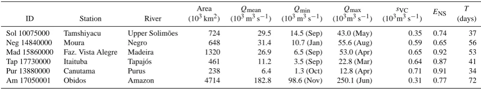
[image:3.595.145.451.61.445.2]Table 1. Gauging stations from Fig. 1a with summary of discharge regime, MGB-IPH model skill and results.
Area Qmean Qmin Qmax sVC T
ID Station River (103km2) (103m3s−1) (103m3s−1) (103m3s−1) (103m3s−1)
ENS
(days)
Sol 10075000 Tamshiyacu Upper Solim˜oes 724 29.5 14.5 (Sep) 43.0 (May) 0.35 0.74 37
Neg 14840000 Moura Negro 648 31.4 10.7 (Jan) 55.6 (Aug) 0.59 0.65 56
Mad 15860000 Faz. Vista Alegre Madeira 1320 26.9 6.5 (Sep) 53.0 (Apr) 0.65 0.92 53
Tap 17730000 Itaituba Tapaj´os 461 11.2 3.5 (Sep) 22.8 (Mar) 0.64 0.87 41
Pur 13880000 Canutama Purus 238 6.4 1.3 (Oct) 12.8 (Apr) 0.71 0.91 34
Am 17050001 Obidos Amazon 4714 182.8 98.6 (Nov) 250.1 (Jun) 0.31 0.77 72
Qmean– mean discharge,QminandQmax– minimum and maximum monthly discharge derived from climatology with respective time of occurrence,sVC– seasonal coefficient
of variability computed as the ratio between the standard deviation of monthly discharges andQmean,ENS– Nash and Suttcliffe index from simulated and observed discharges,T
values as described in Sects. 2.2 and 3.1.
initial conditions from past years forced by a perfect forecast (see Fig. 2b). The initial conditions ensemble is obtained using the hydrological model forced by observed meteoro-logical data resampled from past years during the spin-up period (up to the date of forecast) (e.g. model initial states from 15 June of years 1998, 1999, . . . , 2009). Observed me-teorological data from current year is used as perfect mete-orological forecast (e.g. metemete-orological data form 15 June to 25 September 2000). Consequently, the reverse-ESP pro-duces a proxy of stream flow forecast uncertainty due to model initial conditions errors. Model climatology (Fig. 2c), where either initial conditions and meteorological forcings are unknown, is used as a reference for comparing ESP and reverse-ESP model runs.
We use the ensemble spread (either for ESP, reverse-ESP and model climatology) as a measure of uncertainty in stream flow forecasts. For a given forecastj starting at the time in-tervalt0 and atτ lead time, the ensemble spreadS is
com-puted as the mean square deviation using simulated discharge
Qsim, as a reference:
S (τ, j )= 1
N
N
X
i=1
Qensi−Qsim 2
, (1)
whereN is the ensemble size andQensi is stream flow from ensemble memberi. The indexest andτ were omitted for simplicity.S is computed for the ESP (SESP), reverse-ESP
(Srev-ESP)and model climatology (SCLIM)ensembles. For a
proper evaluation of stream flow uncertainty in different time periods, the model climatology is used as a reference and relative spreads are computed asSESP∗ = SESP/ SCLIM and
Srev-ESP∗ =Srev-ESP/SCLIM. Finally, results are averaged from
all forecasts:
S∗(τ )= 1
M
M
X
j=1
S∗(τ, j ), (2)
whereMis the total number of forecasts performed in the test period andS∗(τ) is the relative ensemble spread as function of the lead timeτ.
The comparison of the spread of both sets of ensembles allows the evaluation of the relative importance of the
ini-tial conditions and meteorological forcings on model pre-dictability as functions of lead time (see Fig. 2d). Moreover, a proxy of the river “memory”T can be obtained by verifying in which lead timeτ the spread of ESP ensemble becomes larger than the reverse-ESP:
T = min(τ )|Srev-ESP∗ (τ ) < S∗ESP(τ ). (3)
2.3 Hydrological model
We used the MGB-IPH model (Collischonn et al., 2007; Paiva et al., 2011), which is a large scale, distributed and process-based hydrological model with a hydrodynamic module described in Paiva et al. (2011b). It simulates surface energy and water balance and also discharge, water level and flood inundation on a complex river network. We used results from a model application in the Amazon River basin (Fig. 1a) presented in Paiva et al. (2012b), as briefly described be-low. The model was forced using TRMM 3B42 precipita-tion estimates (Huffman et al., 2007), with spatial resoluprecipita-tion of 0.25◦×0.25◦ and daily time step for a period spanning 12 yr (1998–2009) and meteorological data obtained from the CRU CL 2.0 dataset (New et al., 2002). Stream gauge data were provided by the Brazilian Agency for Water Re-sources (ANA), the Peruvian and Bolivian National Mete-orology and Hydrology Services (both SENAMHI) and the HYBAM program (Hydrology, Biogeochemistry and Geo-dynamic of the Amazon Basin, http://www.ore-hybam.org/). The model parameters related to soil water budget were cali-brated using discharge data from part of the stream gauges (47 stations). Then, the model was validated against dis-charge and water level data from stream gauge stations (111 and 69 sites, respectively), water levels derived from EN-VISAT satellite altimetry data (Santos da Silva et al., 2010) (212 sites), Terrestrial Water Storage from GRACE mis-sion (Tapley et al., 2004a, b) and flood inundations ex-tent from Papa et al. (2010). Comparisons between simu-lations and observations showed relatively high Nash and Suttcliffe index (ENS) values and a good model performance.
ENS values were larger than 0.6 in ∼70 % of discharge
gauges, and Table 1 showsENS ranging from 0.65 to 0.91
R. C. D. Paiva et al.: On the sources of hydrological prediction uncertainty in the Amazon 3131
Fig. 2. Schematic representation of evolution of hydrologic states in spin-up and forecast for (a) ESP approach, (b) reverse-ESP approach, (c) climatology and (d) relative ensemble spreadS* as function of lead timeτ. Modified from Wood and Lettenmaier (2008).
(Fig. 1a). Also,ENSvalues were larger than 0.6 in∼60 %
of the water level stations derived from satellite altimetry. Similarly, total Amazon flood extent and terrestrial water storage agreed with observations, withENS values of 0.71
and 0.93, respectively.
2.4 Model runs
We performed 6 different model runs: (i) a retrospective sim-ulation from which the ensemble of model climatology is de-rived and used as initial conditions for rev-ESP runs; (ii) an ESP run; (iii) a ESP run; and three restricted reverse-ESP runs, where (iv) in the first only surface waters state variables (river discharge and water level, floodplain storage and surface runoff) are considered; (v) in the second only soil moisture state variable is considered; and (vi) in the latter only groundwater state variables are considered. In all model runs, simulations used the 1998 to 2009 time period and en-sembles have 12 members. ESP and reverse-ESP model runs generated 4 forecasts per year with up to 100 days lead time
starting on 15 March, 15 June, 15 September and 15 De-cember. Note that since we are using meteorological data obtained from the CRU CL 2.0 dataset (New et al., 2002), which provides only climatological values, uncertainty of meteorological variables different from precipitation is not accounted. We choose this simplification because MGB-IPH model using CRU CL 2.0 showed a reasonable performance when results were compared with observations (Paiva et al., 2012b), and most of Amazon discharge variability is due to precipitation variability.
3 Results
3.1 Forecast uncertainty in main rivers
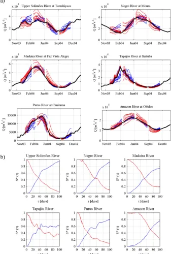
example (Fig. 3). Results show to be different for each site, although some characteristics are found in all of them.
In upper Solim˜oes River, discharge starts to rise in September, and the spread of the ESP run rapidly surpasses the spread of the reverse-ESP run, showing that the impor-tance of uncertainties in meteorological forcings is larger than from initial conditions (Fig. 3a). This situation changes in the other forecasts (at high water period in forecasts start-ing on 15 December and 15 March and in flow recession starting on 15 June) when the uncertainty in initial condi-tions appears to be more important than meteorological forc-ings. On average, the spread of the ESP ensembleSESP∗ takes 37 days to surpass the spread of the reverse-ESP ensemble (T= 37 days in Fig. 3b).
At the Negro River site, discharges rise during the MAM period, and differently from upper Solim˜oes River, the fore-cast uncertainty due to initial conditions shows to be compa-rable, with uncertainty due to meteorological forcings even for large lead times (Fig. 3a). This characteristic is also present at high water (JJA) and flow recession periods (SON and DJF), and as a consequence, only after 56 days uncer-tainty in meteorological forcings becomes more important than in initial conditions (Fig. 3b).
At the rivers draining the southeast part of the Amazon with a southern tropical regime – namely Madeira, Purus and Tapaj´os Rivers – some common features are found. In the DJF period when discharge slowly starts to rise, and in the MAM period when it increases rapidly almost to flood peak, initial conditions uncertainties are important at the beginning of forecasts but the weight of meteorological forcings uncer-tainty becomes larger for smaller lead times. In contrast, at high water periods (JJA), flow recession and low water period (SON), the spread of reverse-ESP ensemble greatly surpasses the spread of the ESP ensemble, showing that initial condi-tions errors may have a large influence in flow forecasts un-certainty (Fig. 3a).T values of Purus, Tapaj´os and Madeira Rivers showed to be different and approximately 34, 41 and 53 days, respectively (Fig. 3b).
In the Amazon main stem, analysis show that the spread of reverse-ESP ensemble greatly surpass the spread of ESP ensemble in all periods of the year, including high water (MAM), low water (SON), rising (DJF) and falling (JJA) pe-riods (Fig. 3a). Uncertainty in meteorological forcings be-comes more important than in initial conditions only after 72 days (Fig. 3b).
Meteorological forcings seem to play an important role in forecast uncertainty at the rising water period, but this is not valid or not so strong in some of the largest rivers, such as Solim˜oes, Negro and Amazon. Perhaps this is due to the flood travel times in these rivers and the contribution of lagged hydrographs from areas with different hydrological regimes (Sect. 2.1). In all rivers, the influence of initial condi-tions greatly surpasses MF’s in high water period and mostly in flow recession and low water period. This characteristic in flow recession and low water period is very strong in rivers
with southern tropical regime where rainfall seasonality is stronger and there is a very marked dry season (Espinoza et al., 2009a, b), as described in Sect. 2.1. In all Amazon large rivers,T values can be considered very large, ranging from ∼30 days at Purus Rivers to∼70 days in the Amazon River, showing that uncertainty on initial conditions may play an important role for hydrological predictability even for large lead times (∼2 or 3 months).
3.2 Spatial analysis
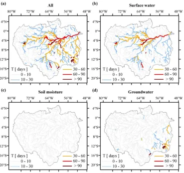
We investigate the spatial distribution ofT values, indicat-ing at which lead time uncertainty in meteorological forc-ings becomes more important than initial conditions for hy-drological predictability, serving as a proxy of river “mem-ory”. According to Fig. 4a, largeT values are found at al-most all Amazonian Rivers.T values smaller than 10 days are found mostly in headwater and in the Andean region at west part of the Amazon where high river slopes are present (see also Fig. 1a). In most of the Amazon main tributaries, including Solim˜oes, Juru´a, Purus, Madeira, Tapaj´os, Xingu and Negro River, it is larger than 30 days and in Amazon main stem it is between 2 and 3 months. Results show that initial conditions may be the main source of discharge fore-cast uncertainty, even for large lead times (∼1 to 3 months) in most Amazonian Rivers.
Results from restricted reverse-ESP runs (Fig. 4b, c and d) show larger T values in analyzes considering only sur-face waters state variables (Fig. 4b). This suggests that initial conditions of surface waters state variables, which include river discharge and water levels, surface runoff and flood-plain storage, are the major source of hydrological forecast uncertainty. This characteristic is present mostly in Solim˜oes, Negro, Purus, Japur´a, Madeira and Amazon Rivers that are located in low slope regions (Fig. 1a) with large seasonally inundated floodplains (see Fig. 1b), as described in Sect. 2.1.
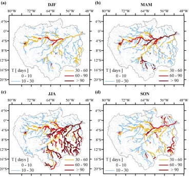
T values in analyses using soil moisture restricted reverse-ESP run (Fig. 4c) are always less than 10 days, showing that initial conditions of soil moisture are not as important as ini-tial conditions of other state variables. Finally, groundwater state variables showed to be important mostly in Tapaj´os and Xingu River basins located at southeast part of the Amazon. The relative importance of meteorological forcings and initial conditions as sources of hydrological prediction uncer-tainty is variable according to the period of the year, as shown by seasonal analyses of T values (Fig. 5). At rivers drain-ing extensive floodplains, such as Solim˜oes, Negro, Juru´a, Madeira and Purus, T values are always large, especially in high water and falling periods (MAM and JJA, see also Fig. 3). In these time periods,T values larger than 90 days are found in the Amazon main stem.
R. C. D. Paiva et al.: On the sources of hydrological prediction uncertainty in the Amazon 3133
Fig. 3. Retrospective simulation (black), ESP (blue) and reverse-ESP (red) (a) discharge results and (b) relative ensemble spreadS∗(τ) as function of the lead timeτ. Results are presented at upper Solim˜oes (Sol), Negro (Neg), Madeira (Mad), Tapaj´os (Tap), Purus (Pur) and Amazon (Am) Rivers at sites shown in Fig. 1a.
10 to 30 days. But it increases a lot in low water period (JJA, SON), reaching values larger than 90 days. It shows that in this region, initial conditions are more important for hydro-logical prediction during low flows.
Results show that in rivers with extensive floodplains, ini-tial conditions of surface waters state variables are the
Fig. 4. Spatial distribution ofT values considering (a) all, (b) surface water, (c) soil moisture and (d) groundwater model states variables. Results are shown only in rivers reaches with upstream drainage area larger than 3000 km2.
On the other hand, at the southeast part of the basin (mainly at Tapaj´os and Xingu Rivers), initial conditions play an important role for prediction of low flows and ground-water state variables showed to be important. This region is the one that presents the strongest rainfall seasonality with a marked dry season, as discussed in Sect. 2.1 and by Espinoza et al. (2009a, b). It is also located mostly in the Brazilian Shield where lithological characteristics differ from the rest of the basin (Figs. 1a and 2c). So, a possible explanation for this behavior is that during low flows period, river discharge may be dominated by base flow, which is directly related to groundwater storage.
Finally, in a first comparison, our results disagree with Shukla et al. (2011), who applied the same methodology in a global analysis, presenting results that show that me-teorological forcings uncertainties dominate the hydrologi-cal prediction uncertainty in the Amazon, even for shorter lead times. However, the results are not fully comparable since we evaluated river discharge while these authors stud-ied cumulative runoff, which does not take into account flow routing throughout river, floodplain and groundwater
reservoirs. Consequently, the water time traveling throughout these hydrological compartments and the associated mem-ory to initial water storage in these reservoirs are not con-sidered, which is probably the reason for the disagreement between results.
4 Conclusions
We investigate the importance of model initial conditions and meteorological forcings as sources of hydrological predictions uncertainty in the Amazon River basin. Our investigations show that in the Amazon River basin:
R. C. D. Paiva et al.: On the sources of hydrological prediction uncertainty in the Amazon 3135
Fig. 5. Spatial distribution ofT values considering (a) DJF, (b) MAM, (c) JJA and (d) SON time periods. Results are shown only in rivers reaches with upstream drainage area larger than 3000 km2.
development of data assimilation methods is encour-aged for reducing model initial conditions uncertainty. 2. Initial conditions of surface waters state variables are
the major sources of hydrological forecast uncertainty, mainly in rivers with low slope and large floodplains, such as Solim˜oes, Juru´a, Japur´a, Madeira, Negro and Amazon Rivers. Initial conditions of groundwater state variables are important mostly in the southeast part of the Amazon, in Tapaj´os as Xingu Rivers. Soil moisture is not as important as other state variables as a source of hydrological prediction uncertainty.
3. The relative importance of meteorological forcings and initial conditions as sources of hydrological predic-tion uncertainty is variable according to the period of the year.
4. At rivers draining extensive floodplains, initial condi-tions are more important in all time periods but espe-cially in high water and falling periods (MAM and JJA). This can be related to the large flood wave travel times of these rivers, where these flood waves are delayed
because floodplains store large volumes of water and release it slowly.
5. Meteorological forcings are more important in the be-ginning of the rainy season when hydrographs are rising, especially at the rivers draining southeast. 6. At the southeast part of the basin, mainly at Tapaj´os and
Xingu Rivers, initial conditions play an important role for prediction of low flows (JJA, SON), and groundwa-ter state variables showed to be important. A possible reason is that this region is the one that presents the strongest rainfall seasonality with a marked dry season. Lithology may be an explaining factor, since this region is located mostly over the Brazilian Shield.
Results indicate that hydrological forecasts based on phys-ically based and distributed hydrological models forced with past climate and optimal initial conditions may be feasible in the Amazon River basin and possibly in other world large rivers. It should also be mentioned the potentiality of recent remote sensing developments for providing past meteorolog-ical forcings (e.g. Tropmeteorolog-ical Rainfall Measurement Misson, Huffman et al., 2007, and others) and information to update model states, such as radar altimetry based water levels or discharge derived from previous (Alsdorf et al., 2007; Santos da Silva et al., 2010) or the future SWOT mission (Durand et al., 2010).
Acknowledgements. The authors are grateful for: the financial
support from the Brazilian agencies FINEP and ANA (“Projeto de Integrac¸˜ao e Cooperac¸˜ao Amazˆonica para a Modernizac¸˜ao do Mon-itoramento Hidrol´ogico” (ICA-MMH)) and CNPq (“Assimilac¸˜ao de Dados de monitoramento Espacial para a an´alise do regime hidrol´ogico da Bacia Amazˆonica e a previs˜ao de curto e m´edio prazos”); the TRMM data supplied by NASA and associated agencies; the global inundation extent dataset provided by Fab-rice Papa; as well for the constructive comments from Sylvain Mangiarotti and Shraddhanand Shukla, and also from Wouter Buytaert, editor from HESS, Matthieu Guimberteau and the other anonymous reviewer.
Edited by: W. Buytaert
The publication of this article is financed by CNRS-INSU.
References
Alsdorf, D. E., Rodr´ıguez, E., and Lettenmaier, D. P.: Measur-ing surface water from space, Rev. Geophys., 45, RG2002, doi:10.1029/2006RG000197, 2007.
Beighley, R. E., Eggert, K. G., Dunne, T., He, Y., Gummadi, V., and Verdin, K. L.: Simulating hydrologic and hydraulic processes throughout the Amazon River Basin, Hydrol. Process., 23, 1221– 1235, 2009.
Cappelaere, B., Lub`es-Niel, H., Berkhoff, C., Th´epaut, H., Guyot, J. L., de Oliveira, E., and Rodrigues, M.: Pr´evisions des crues de l’Amazone. In: /. ’hydrologie tropicale: g´eoscience et outil pour le d´eveloppement (Actes de la conf´erence de Paris, mai 1995), 355–366. IAHS Publ. no. 238, 1996.
Chen, J. L., Wilson, C. R., Tapley, B. D., Zang, Z. L., and Niu, G. Y.: The 2005 drought event in the Amazon River basin as measured by GRACE and estimated by climate models, J. Geophys. Res., 114, B05404, doi:10.1029/2008JB006056, 2009.
Chen, J. L., Wilson, C. R., and Tapley, B. D.: The 2009 excep-tional Amazon flood and interannual terrestrial water storage change observed by GRACE, Water Resour. Res., 46, W12526, doi:10.1029/2010WR009383, 2010.
Coe, M. T., Costa, M. H., and Howard, E. A.: Simulating the sur-face waters of the Amazon River basin: Impacts of new river geo-morphic and flow parameterizations, Hydrol. Process., 22, 2542– 2553, 2007.
Collischonn, W., Haas, R., Andreolli, I., and Tucci, C. E. M.: Focasting river Uruguay flow using rainfall forecasts from a re-gional weather-prediction model, J. Hydrol., 305, 87–98, 2005. Collischonn, W., Allasia, D. G., Silva, B. C., and Tucci, C. E. M.:
The MGB-IPH model for large-scale rainfall-runoff modeling, Hydrolog. Sci. J., 52, 878–895, 2007.
Day, G. N.: Extended streamflow forecasting using NWSRFS, J. Water Resour. Plann. Manage., 111, 157–170, 1985.
Decharme, B., Douville, H., Prigent, C., Papa, F., and Aires F.: A new river flooding scheme for global climate applications: Off-line evaluation over South America, J. Geophys. Res., 113, D11110, doi:10.1029/2007JD009376, 2008.
Durand, M., Fu, L. L., Lettenmaier, D. P., Alsdorf, D. E., Rodr´ıguez, E., and Fernandez, D. E.: The surface water and ocean topog-raphy mission: Observing terrestrial surface water and oceanic submesoscale eddies, Proc. IEEE, 98, 766–779, 2010.
Durr, H. H., Meybeck, M., and Durr, S. H.: Lithologic composi-tion of the Earth’s continental surfaces derived from a new digital map emphasizing riverine material transfer, Global Biogeochem. Cy., 19, GB4S10, doi:10.1029/2005GB002515, 2005.
Espinoza, J. C., Ronchail, J., Guyot, J. L., Cocheneau, G., Filizola, N., Lavado, W., de Oliveira, E., Pombosa, R., and Vauchel, P.: Spatio – Temporal rainfall variability in the Amazon Basin Coun-tries (Brazil, Peru, Bolivia, Colombia and Ecuador), Int. J. Cli-matol., 29, 1574–1594, 2009a.
Espinoza, J. C., Guyot, J. L, Ronchail, J., Cocheneau, G., Fili-zola, N., Fraizy, P., Labat, D., de Oliveira, E., Ordo˜nez, J. J., and Vauchel, P.: Contrasting regional discharge evolutions in the Amazon Basin, J. Hydrol., 375, 297–311, 2009b.
Espinoza, J. C., Ronchail, J., Guyot, J. L., Junquas, C., Vauchel, P., Lavado, W., Drapeau, G., and Pombosa, R.: Climate variabil-ity and extreme drought in the upper Solim˜oes River (western Amazon Basin): Understanding the exceptional 2010 drought, Geophys. Res. Lett., 38, L13406, doi:10.1029/2011GL047862, 2011.
Farr, T. G., Caro, E., Crippen, R., Duren, R., Hensley, S., Kobrick, M., Paller, M., Rodriguez, E., Rosen, P., Roth, L., Seal, D., Shaf-fer, S., Shimada, J., Umland, J., Werner, M., Burbank, D., Oskin, M., and Alsdorf, D.: The shuttle radartopography mission, Rev. Geophys., 45, RG2004, doi:10.1029/2005RG000183, 2007. Getirana, A. C. V., Bonnet, M.-P., Rotunno Filho, O. C.,
Col-lischonn, W., Guyot, J.-L., Seyler, F., and Mansur, W. J.: Hydro-logical modelling and water balance of the Negro River basin: evaluation based on in situ and spatial altimetry data, Hydrol. Process., 24, 3219–3236, 2010.
R. C. D. Paiva et al.: On the sources of hydrological prediction uncertainty in the Amazon 3137
doi:10.5194/hess-16-911-2012, 2012.
Hess, L. L., Melack, J. M., Novo, E. M. L. M., Barbosa, C. C. F., and Gastil, M.: Dual-season mapping of wetland inundation and vegetation for the central Amazon basin, Remote Sens. Environ., 87, 404–428, 2003.
Huffman, G., Adler, R., Bolvin, D., Gu, G., Nelkin, E., Bowman, K., Hong, Y., Stocker, E., and Wolff, D.: The TRMM Multi-satellite Precipitation Analysis (TCMA): quasi-global, multiyear, combined-sensor precipitation estimates at fine scales, J. Hy-dromet., 8, 38–55, 2007.
Liu, Y. and Gupta, H. V.: Uncertainty in hydrologic modeling: To-ward an integrated data assimilation framework, Water Resour. Res., 43, W07401, doi:10.1029/2006WR005756, 2007. Kerr, Y., Waldteufel, P., Wigneron, J.-P., Martinuzzi, J.-M., Font,
J., and Berger, M.: Soil moisture retrieval from space: The soil moisture and ocean salinity (SMOS) mission, IEEE T. Geosci. Remote Sens., 39, 1729–1736, 2001.
Marengo, J., Nobre, C., Tomasella, J., Oyama, M., de Oliveira, G., de Oliveira, R., Camargo, H., and Alves, L.: The drought in Ama-zonia in 2005, J. Climate, 21, 495–516, 2008.
Marengo, J. A., Tomasella, J., Alves, L. M., Soares, W. R., and Ro-driguez, D. A.: The drought of 2010 in the context of historical droughts in the Amazon region, Geophys. Res. Lett., 38, L12703, doi:10.1029/2011GL047436, 2011.
New, M., Lister, D., Hulme, M., and Makin, I.: A high-resolution data set of surface climate over global land areas, Climate Res., 21, 1–25, 2002.
Paiva, R. C. D., Collischonn, W., and Tucci, C. E. M.: Large scale hydrologic and hydrodynamic modeling using limited data and a GIS based approach, J. Hydrol., 406, 170–181, 2011.
Paiva, R. C. D., Collischonn, W., and Buarque, D. C.: Validation of a full hydrodynamic model for large scale hydrologic modelling in the Amazon, Hydrol. Process., in press, doi:10.1002/hyp.8425, 2012a.
Paiva, R. C. D., Collischonn, W., Bonnet, M. P., Buarque, D. C., Frappart, F., Calmant, S., and Mendes, C. B.: Large scale hydro-logic and hydrodynamic modelling of the Amazon River basin, Water Resour. Res., in review, 2012b.
Papa, F., Prigent, C., Aires, F., Jimenez, C., Rossow, W. B., and Matthews, E.: Interannual variability of surface wa-ter extent at global scale, J. Geophys. Res., 115, D12111. doi:10.1029/2009JD012674, 2010.
Prigent, C., Papa, F., Aires, F., Rossow, W., and Matthews, E.: Global inundation dynamics inferred from multiple satellite ob-servations, 1993–2000, J. Geophys. Res., 112, 1993–2000, 2007. Reichle, R. H.: Data Assimilation methods in Earth sciences, Adv.
Water Resour., 31, 1411–1418, 2008.
Santos da Silva, J., Calmant, S., Seyler, F., Rotunno Filho, O. C., Cochonneau, G., and Mansur, W. J.: Water levels in the Ama-zon basin derived from the ERS 2 and ENVISAT radar altimetry missions, Remote Sens. Environ., 114, 2160–2181, 2010. Schongart, J. and Junk, W. J.: Forecasting the flood-pulse in Central
Amazonia by ENSO-indices, J. Hydrol., 335, 124–132, 2007. Shukla, S. and Lettenmaier, D. P.: Seasonal hydrologic
predic-tion in the United States: understanding the role of initial hy-drologic conditions and seasonal climate forecast skill, Hy-drol. Earth Syst. Sci., 15, 3529–3538, doi:10.5194/hess-15-3529-2011, 2011.
Shukla, S., Sheffield, J., Wood, E. F., and Lettenmaier, D. P.: Rel-ative contributions of initial hydrologic conditions and seasonal climate forecast skill to seasonal hydrologic prediction globally, Abstract H51N-05 presented at 2011 Fall Meeting, AGU, San Francisco, Calif., 5–9 December, 2011.
Tapley, B. D., Bettadpur, S., Watkins, M., and Reigber, C.: The gravity recovery and climate experiment: mission overview and early results, Geophys. Res. Lett., 31, L09607, doi:10.1029/2004GL019920, 2004a.
Tapley, B. D., Bettadpur, S., Ries, J. C., Thompson, P. F., and Watkins, M.: GRACE measurements of mass variability in the Earth system, Science, 305, 503–505, 2004b.
Thielen, J., Bartholmes, J., Ramos, M.-H., and de Roo, A.: The Eu-ropean Flood Alert System – Part 1: Concept and development, Hydrol. Earth Syst. Sci., 13, 125–140, doi:10.5194/hess-13-125-2009, 2009.
Tomasella, J., Borma, L. S., Marengo, J. A., Rodriguez, D. A., Cuar-tas, L. A. Nobre, C. A., and Prado, M. C. R.: The droughts of 1996–1997 and 2004–2005 in Amazonia: hydrological re-sponse in the river main-stem, Hydrol. Process., 25, 1228–1242, doi:10.1002/hyp.7889, 2010.
Trigg, M. A., Wilson, M. D., Bates, P. D., Horritt, M. S., Alsdorf, D. E., Forsberg, B. R., and Vega, M. C.: Amazon flood wave hydraulics, J. Hydrol., 374, 92–105, 2009.
Uvo, C. B. and Graham, N. E.: Seasonal runoff forecast for north-ern South America: A statistical model, Water Resour. Res., 34, 3515–3524, doi:10.1029/98WR02854, 1998.
Uvo, C. B., T¨olle, U., and Berndtsson, R.: Forecasting discharge in Amazonia using artificial neural networks, Int. J. Climatol., 20, 1495–1507, doi:10.1002/1097-0088(200010)20:12<1495::AID-JOC549>3.0.CO;2-F, 2000.
Vinukollu, R. K., Wood, E. F., Ferguson, C. R., and Fisher, J. B.: Global Estimates of Evapotranspiration for Climate Studies us-ing Multi-Sensor Remote Sensus-ing Data: Evaluation of Three Process-Based Approaches, Remote Sens. Environ., 115, 801– 823, doi:10.1016/j.rse.2010.11.006, 2011.
Wood, A. W. and Lettenmaier, D. P. An ensemble approach for attri-bution of hydrologic prediction uncertainty, Geophys. Res. Lett., 35, L14401, doi:10.1029/2008GL034648, 2008.
Wood, A. W. and Schaake J. C.: Correcting errors in streamflow forecast ensemble mean and spread, J. Hydrometeorol., 9, 132– 148, 2008.
Wood, A. W., Maurer, E., Kumar, A., and Lettenmaier, D. P.: Long-range experimental hydrologic forecasting for the eastern United States, J. Geophys. Res., 107, 4429, doi:10.1029/2001JD000659, 2002.
Yamazaki, D., Kanae, S., Kim, H., and Oki, T.: A physi-cally based description of floodplain inundation dynamics in a global river routing model, Water Resour. Res., 47, W04501, doi:10.1029/2010WR009726, 2011.