1
.. ,
.
'Y.i1.e J2.8velopmen-c of Con:;lrc'..!.'1ication LinesAcross - -
-The'Taranaki Uplands.
'.j
A Thesis PreS621ted For
Tlie Degree of lCGA 0 and Honours.
Univ'ersity of NeVI Zealand
949
,)li
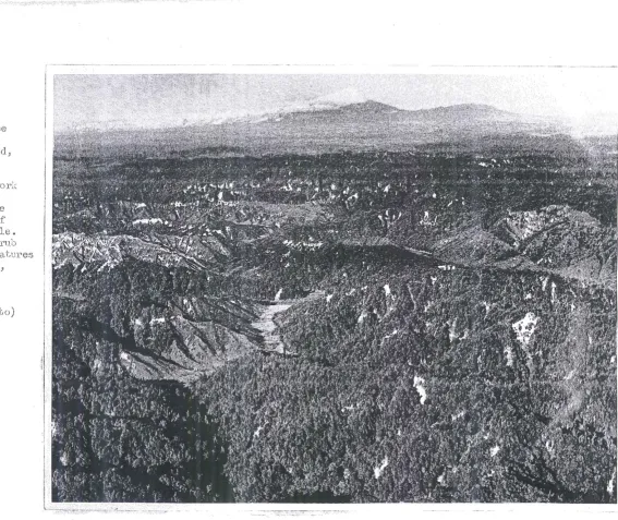
Fig. 1. 'rhi.s ~d.j:' phuGO shc\:;~.J Lhe three (:)Jements ufLll (:'; t cf ~i\)I'an;:.lL'i.. I.i.i the h:lckgr.';)tmd l.'~~;e.s 'l~hr:=J c1oIJ.c1-ca.pped, "iJ"().l.c<':'i.n:i.c cone uf Egr:1ont
U')
260 t ) •. ~)Ul'J.'OlJl.ldL·ig Llw peL).:.;: i),nu. :i:ts ):'clllges are LJJ(:J T;j,:t:'anak::L Im-Jlcui(1::';i1iLth their p;:J,i.:,cin'ToJ:'~;: lilll c.lscci-j)e. In the foreground J5e the tangled rid!!;es aild l1ci,r.C01'J vaJ.le)'fj of the T,trc.naki Uplcl,nds. Dtriking e:;;:;J,mpleS of the mass lwvement of !:'iO i1 ct1'8 j.r.lnuri181'able. J.1.eve:t'sio.n of th(~ cleJ'ol'eu Led hill~3 to scrub cJ.nd forest i.s evident. IJd.JlY uf the features th,:d, l.la.ve lYfl.de tile Uplands D • . p8l'sistent., t01J0.g l·,?~phic I:)ar:cier are portrayed.
(V • C. f.lroirirJ.e phnt 0 )
I
I.
)
.)
l
l
.,
•• _ _ _ _ ~ •• M •• _MM.MM _._ •• _
[image:2.844.258.826.59.536.2]CHAPTER I
CHAPTER I I
CHAPTER I I I
CHAPTER IV
CHAPTER V
CI-IAPTER VI
CONTENTS
A ckno 1'vledgement s
List of Haps
Introduction
The Taranaki UJJlands in relation to Settlement and Corrrrnu.n.ication Lines.
A. Expansion of Settlement from Nel,i Plymouth.
B. E:1..'Pansion of Settlement from Auckland.
C. Pl-:ysical Geograp}w of the Taranaki UplandS.
'rhe Development of Communication Ljines Across the Tar&!aki Uplands lliltil 1908.
l~ori trails: co~~ications 1841-1890: com~u.nications 1890-1908: conclusion.
TI1e Construction and Development of the Railway as a Cownunication Line.
Ea.r ly develo?ment: th e clo si...n.g of the Tahora-Ohura gap: problems i...n. con-struction: value of the railway.
The Construction and Development of Roa.ds Across the Taranaki Uplands.
Coastal road: inland road: Ahititi-Ohura road: conclusion.
The Present Pattern of CCD.'l.lUl"1ications a"1d its Relation to the Distribution of Population.
--Patteri1(;'f'"' comn:ru.I1ications: relation to dj.stribution of population: pattern of settlement.
The Expanding Hinterland of Ne1rl Pl;Xillouth. Early gr01'fth 184 i -1908: expansion and
competition 1908-1932: consolidation.
Problems and Prospects
Appendix:
(A) A Note on Haps
(B) A Specific Area on the Ahititi-Ohura Road.
Bibliography.
", I \ •.. . / _~ • j
The author expresses sincere appreciation to the m~my people
lI'J110, by the extension of hospitality ar.rl in.i'onna. t..ion supplied, have J'ilade possible t~e preps,rat ion of this paper. S~)ecial ac~:nm'rledgement
is made .to the IolloirJing:
lciessrs. D.F.C. Sa.xton, llanaging Editor, 'l'aranaki Daily NelrJ's"
Keh1 Plymouth; ~'>J. Bridger, I'Jev-T Pl;Y-nlou:th; G. F:caser, New Pl~7!nouth; }~. Ivlackinder" l-Iatiere;
F .1.10 berts" Engineer
to the Taral1a;--;:i C01 .. mty COll.neil and Hain Highirla;ys Board, Zone No.7,
IJe"',j Plymo"l;.th; A. E. L01'!e" Public Library, Ne\-J Plymouth; G.C. Heron, Turnbull Library, '('{ellington; the Sta:c.:LonllE.ster, Stratford; the
}ianager, Henry Brc.n'.1l1 and Company, r~eVi Plym.outh; the :Manager, Boon
31'0 S ., N e'w Pl:;n:wuth; the Secretary, Taranaki Automobile Association,
"or.: F .li. Aickin, General }:Ianager, Hew Zealand Raill,.vays,
~Iellington ~ for the use of his library; and the Staff' of the Lands
and
Survey Depart,ment, Ne~"J Pl;-}tTIlouth, for considerable help inover-COD.1L.'1g the many problems created by the absenc:e of detailed topographic
~. )
?'igure
2
7
10
20
23
52
53
57
63
68
List of Haps.
Location
Distrib-utiOl1 of Popu.la tioD 18960 Regional Boundaries.
Eiver Pattern.
Relief.
Rai l :.=1.outes.
Corr~lul1icatiol1 Pattern. Far:rcLng }'iap.
Population 1945. Hoa.d DistallCes. Contoured Area.
\
.
I, i' I
I ii
I
i
,'j
~.
II\:-TRODUCTION
A characteristic feature of the topo,si."'aph;/ ') of Nev.J Zealand
is the presence sf s:rnall, coas-tal ~)lai~1s ~ commonly seps.:ra,ted f:.:'Om e.::;,c11 other by l..1psta:J.dins a reas or :::,ugged relief. ,since n13.n first
set, foot on the isl::1.nds, physical b2.r!"'1B rs h3. ve hindered the
de-'lelopment of both cOITLUl1ications .::md settle:nent. 'The Haoris Here
confronted l.-.rith th-:: difficulties of land tra:vel bet-,··jeen t::''"'ibaJ.
centres.
of sea co:rrrnunications.. 1:'1 the l";oI,th Island, as s.ettlers occupied
th.e i,)lore f 2~vGurable lm'ilands, 'eta Y·'laori tr.L'Jes ,'Jere for ced to Yn..CTve
Thus, to t.118
EtJ.ropean3, ]...3,nd cOJill:ltmication oab·ree;:l their scatt'3red settlemsn.ts
--;"'l r::_
- - " ' 0
alien ci ~v:l.J.i.z.:?"tiol1.
inland explorD.:tion he.d begun, princi:pall}, by mis5ionaries. The
na.ture of the COU!1tl"'"j' in bot~ the North a.nd South Isla.YJ.ds, it is
clear, prevented the success of a fe-..", S:{s·c-ematicalJ.y ~)lsnned
e.';cped-it.i0ns~ E:x:ploration. h:1d 'GO be carried on from many i.t.1.connected bases.
The ep.:i.c of e:;91oro.tion .for:us no si~lgle .,cohe:.'.")nt 3tory but a complex,
e1Jisodic chJ:"::nicle.
pendence a,nei self-s:Ji'.i.'ici,,:ncy. Th~i;'emovc.l cf the isolation. has
been directly related to ';:'118 d evelo~Jm~nt of :i1odern comr:ru2.1ication
ii.
past has p~rsistede It is e::;'Cpressed in the distinct regional
day New Zealand 0
In. an attempt "C() port~('ay and qualify these varied features, a loc.'?l eXc3..:nple h3.s been studiede
settlements in Nevi Zealand l,\laS that of the ~:lakefield colony of Nevi
Plyr:.rJ.outh, founded on the ~1.:)r-Gh'iJest J coast.a.l margin of the Tarana.~:i
j\~ount Egmont" are enclosed; lal1a.irJards, by a vade, north-east -Go
sout.h-east arc of low but extremely rugged uplands. To this region
of ridge and volley topography has been given the general name of the
( ~ \
Taranaki D:91ands. \ I j During t.he 8c-ll"'ly ~{ears of settlement, the
l"EL."l.ges ~vel"'e regarded as an almost insupel."'alJle b.3rrier to land COTIBl.UD
-ica-:ions, i'Jith -[:'h8 notC1.~;)le exception of the n3.1"1'O\;[, coastal corY'idor
to ·\'Ja..Y1ganui aJld the south. Tl18 most persistent effect of the
top-ographic oi3,!'rier has been in North Taranaki, ia the long period of
land isolation of Ne-LI'! Plymouth fr::m the i,vaikato basL'1 and Auckl3.J.'1d"
ConsequentlY!J IrDY'e a ttentio~1 has been given to tDis a rea"
The thesis is advanced tm t the Taranaki Upla.nds have long
been a barrier to land com'JI1..h'l.icaticns and
settlement ; that their barrier character
is due to the l.'Jide extent of the Uplands aY1d
to a unique c·omhii'Tltion :)f landform, clilmtic
end ves;etation features, l"ather than to their
elevation .3,bove S <8;), level.
In
addition tothe physical oosta.c.lGs, the development of
the present comm1J..l1ication pattern across tbe
Uplands has been long delayed by ecol1<?rnic,
political anJ. financi3.l factors, external to
-the region itselfe During the last t-wo
de-cades, the :i...-rnprovement 8.f cormn.unicatiol1s h2"S
iii.
'.,f>
occasioned a rapid extension of the hint;
er-land of the city-port of New PIJ~outh, thus
bringing about 2-11 inevitable conflict 1\d.th
the cOrITr.8rcial int erests of ~;Ja.ngan1)i arid
\JellingtoD., Hanlilton and Auckland.. The
Uplands ef':'ectively isola,ted the Taranaki
1011\T1a.'1ds during the e.:l.rly 3real"S of set'
l::,le-ment and, alth:.)'ugh the :)arrier ha.s nOH been
penetrated, it is not entirely removed. It
still remains -' t·J hinder, obstruct a.nd, in
and tra vellel'" OJ Finally, it is suggested
tha
t
the Ta.ranaY,i Uplands remain a problem2.1:'83. for preSe!lt:. 5.11d future settlement.
This is due, not only to the l iini ta tions of
the ,environment but, also, to th,~ j,·ridespread
and ill-advised actions of the Europeat'1
settlers during the past SL~Y years. The
~:; latter have played the dJ::ninant role in the
~:'
production of the ma.imed a.l1d sca.rred
l,::md-scapes that exist, today., over Hide tracts
: .. ,.L ..
; !
I
I
I ~ !"
!
'
I
fI
"'-
\ \.;~'"\.J:::J
\
!
,
~
'
/
I
f
!
II
NOP-.TH ISLAND
£/thom e
oHawera
o 'Waver-ley
N
tior-opi to 0
OhQKL4ne e
CHA.P~~R I •
. ~~ . ..,.".--.... -... , ... " ..
T~8 sEttlement of 1-:'21\' Plymouth or Taral12.ki "'13.S founded in
the I\Tet'i Zealand Company. An e::,-cpeT-ienced surveyol"'.~ F. A.Carringt.on
chose the E.ite fer settlement at a point on the coast; tlivO TI".iles
From this pcint to the :rr~outh of the T'Jaita.ra
l"i vel";; there is a nal''Tml" prograded, co,s.stal plain Hhich e:·;tends
hali' 8. 1ni1e inl2.nc1 to the ew."'lcient sea-cliffs, lY,arking the '2dge cf
the T2.ranaki lO't1[lands e The lovllands forrr~ an arc avera.ging ten
If tiles in -l'~-j.dth and extend for fifty D.~iles around. the eastern b2.se
of the vc·lcanic cone of F~o1.)l1t Egr:1Ont & They ::eise from one lrundred
The original
3ettl€-!J'lGnt 1·'JaS conf:L.'1sd to the f;;Cl'ub and fern covered coas.tal plain.
no
c::.ttempt '!.Va.s made te· penet::ats the c.ense sub-tropical r'ai:r!ioY'est',;J11ic11 clothed the Jo1tl1cmds.
On. the morning 0 f lfarch 1841, t'c.e H~{illic9.:m BrycU1!1 a
vessel of 312 t.ODS lanc~ed the first Devon errd.grants, as vmll as
the livestock that had been · brought from England. i:' eDt S ',JeTe
erected for the settlers en the beach but S E:YE:;:2,.l v.rhares l,ihich had
been built to serve 8.S a '\;JTI2.1inE; cent.re, 1iJere available to the
The second shipload of ~,E:ttlE:rs arrived in the
!I.Amelia Thompson!! on September 11th, 1841 but ov.ring to the open
n.atur:e of thE. roadst.ead, the ·'.ill.lo2.ding or addi tiona. 1 food supplies
1:Jas interrupted by a period of north-11i€:;ot v;inds and the vess'el
was forced to return to Port Nicholson. The insecl.;.rity of the
roa.dstead fer vessel9'supplying the colony Y·ia,S apparent. l1I a.ill
exceedingly c.fraid the sehea-ITJ 1:~inds so c:cnst;;.ntly recurring ,;·rl.l l
do :D.'!.cale;u.8,bJ.e injury to the placE:. There is no disguising the
is not at:· all fit for large vesE~els to come here until
\·te haVe sufficient means for c.ischarging thern quickly; [-.nd. e-'len for
small ones i t is a.s bad a.s bad can be as nothin.g can t IS land.ed
;1
.':';;.:
2.
a t the place 1A1i th the 'wind a.t all fresh, 't·ih en blovd.ng from the
north-west even if a vessel can ride safely a.t anchor. II (1)
The settlement la.ng-uishea. for c. period c,lli"'ing Hhich the number
of imrrLi..grants Kas small and tIle replenishment of fouG. supplies
irregular. Ships 1,-.,r culd tCilce no risks ~ A. t. the first E;ign of
wind th\sy 'h;eighed anchor and stood out to sea~ The high costs
involved in the transhipment of goods "lIvere an important factor
in retarding land settlem.ent. The small lcS...llao1ii1TJ:s-rs cocld not
economically clear the forest as ther·e 1iTcl.S, in tbe Early deWS of
the colony, no market for timber. With increased settlement
in Taranaki and a growing dernand this became practica.ble. The
only area on ~ihich the early immigrants could be immediately settled
was the liJaitara block "'(,vnieh, t·eing covered 'trJith a scrub vegetation,
required less effort to clea,r ar.d cultiva.teo Communication
be-t'Heen the ~'J2.itara block and. Ee~·[ Plymo1.A.th ·,,-.l(;tS prLm2Tily by sea but
the bar of the lrJaitara river restricted entrance to vessels of
small tOr'.J!age. Travellers by land encoll.11tered difficulties in
.. ,~
crossing the nuro.ero<J.s stl'ea.rr:s, chief of '. ... hich v.ras {he T)ai'lnkaiho
river - a;t'd.de stre81Tl w'ith a stony bed and subject to occasional
floods c
On June 20th, 1842, the scrub lands. on both sides of the
~'Taitara river lv-ere offered for selection despite wo.rning from the
Haoris that the European se.ttler must. keep to the south side of
the rivere The conflict over rights 0 f oV.'l1eTship herald.ed €:
x-.~. e..spe l"'ating difficulties tha
t
v~ere to leae. to t 11e HE,ori 'h'EtI'S of the~;. The year, 18l,.r2, "'.laS equally important in that althoL,gh
the settlers were not perfectly satisfied vd.th the hc.y·bouTless site
of the New Plymo'ilth colony, they real i sed t.hey had to h'Cl"'k :to
maintain tl1emselves. Devon and Com. ... l'all fc.urd.lies and relatives
L."1 England had responded to the call for &id from the pioneers of
Nel,'l Pl~,7mo1.rth. The settlerrent bego1! to shoil E,igns o:Vr.rogress ~
Nore d1...relli.'1.gs '.:Jere bu.ilt to hO·0..cG the ne"'; ::;hip-·loads of :L'DYfi.grants
from the south of England; t1r~"D sLJall flecks of sheep he.d been bred,
:C.
. ~t
3 .
one of lVlerinos and the other of SOllt.bdol-;ns; C:":, bridle track had been opened. a.round the e.3.sten ba.se of HOll..'1t Egnont throLgh the .i'orest to Ps,tea, a.long 1'\!nicb f:~ev8nty hea,d of cattle and large
numbers of sheep i,··;.e:i'6 driven ireIT'.. Fellinzton to Net·j" Plymou.t.h;
and a. small nucleus of shops a.li:kd bouses formed the tOlJrlship of l\ie1'J Plymouth.
The purCt'-}ase of land continued. despite unsolved questions
of lvI.-3.ori rights of ()v.7!:.ership ..
proved productive, :tThe very large yield of the grain-crop and
the promising appearance of the potc:.toes have in.spired confidence
and good feeling among the settlerso"(1) Indeed, in 1845; barely
four yeal~s after t!'-18 .initi<:i.l settlement, farm product ion ifC;,S in
eJcce.S[j 0.[' lOCFJ.l deman.rJ. Trade v,ra,s begun l"J"ith Nelson and hiellii'1 g-ton. ,settlement expanc:.ed inland and. spread around the coa.st cf Cape Egmont. In 18~-7, the Oln.atct block ·Nas :p1.:r~hasi2d. from the na.ti\res •. The derr£l1c. for l-E~nd necessitated e.xtensive clearir.g
:f"crest fr-om the The forest l:la,S felled d1.u"iDg
bl.i.rnt. anc a thiJl sOI-'ring of 1,kJ.eat made cUilC~J2: the a ;::hes c ;:'effern
records the.
t
the r-eturns from the first rlO~ rvcst v[ere c::~c811ent.,Restoraticn of cbnfidenc3 3.:1'..C~1g the 3sttler.: c!2:Guraged :Ln.crs2.scd
cultiv3.tioD The
the settlemf;:r..t more cs.pit3.1 Eo 1"' the clearing 2.nd cropping of the
nevI land.
their various settlemEnts;. including TaranaY-i, i'Jere sold tc ,the
restrict-ions on land c::eveJ.cpTI~.ent. The pi.i'.::,licc,t ion of the first
cf critic:i~@ and of mCH:.lc5 YJ.g ... ~:,:::.e LillO:tg3T:i::::ed ::;E:t-'L.lers into a
p:i-V-.. :,-+,: .
. 1I~"''':
( 1) Seffern: op. cit. p. 131 1 C:?
.(; ..
.~
em
gressive co;mni)11ity. The district. of Taranaki a-c. this tinE: N&..S c..
s:m..s.ll Emd co:rrtpact area} totalling two and a. half rrillion aCi'es ~
of ,,·;hich less than ninet~r -'Gil.C!usar"c. Kere in the possE:ssion of
..., (1)
.r:., uropeans • ' 'rhe 'village capital of New Pl;;rmorLtll nestled on
the C.Oc3..sta..l plaL':1 beh!een '~h::, cliffed edge of the lOHlands to the
south-east and the se2,. in the 110 rt.h-iN€st. Outlie rs c·f set.tlerrent
had been established at Bell Block, Tatarai!'Llal';:a and Ornata. The
final episode of the i'01..U1QcltioE pe'1'icd of the colony vias the
en-forcement of the nm'! Ccnstit·G.tic)TI Ac.t in 1853. Until tlus act.;!
Taranaki \:\lG.S virtually 't!itho-u.t a Govermnent .. Auc.1cland I.,ras the
In their
isolo.tion othsr district.s llere independent states, ma ... l1aging their
2.ffairs as test sl~itecl 1.oc3.1 conditions.
The ne:;::t tEn yea.rs 1J:itnessed a deterioration i:n the l"elations
bstvieen Eao ri 81d Europew. The J.\Yaori Ls.nd l.ee..gue bound it::;
l'Eember-s !fto sell no lan.d to the European settler and to prchibi.t
by force, if neces:::a.ry-, other's from seili:rg.1f Conflict over l.and
ov,Tlership led to open 1\rarfare in 1860 arlO, for a decade, the
settler had to take up a rifle 2nd. lay elm-·m. the axe. Land
de--irelopment 1':as arrested.
~;!ith the 3.c.:.:es~:ic.n to ofr'ice c1' the rex-VoZel :ministry in '1869,
peac~ ;,-vas proclaJ..r.:led. by the r·Ta.tive hinister, SiT Donald l-'1ac163J; t;
and his Iollol'[ers in 1880(2)
~1.0
furthe.r distur-DCL.llCi3;::; c:ccLrred inE01··!8Ver -' peace, did not resJ,:,ore complete confiden C8
2ID.Ong tl".te settler's. Dense fo rest, tr8.vel"~.ed: cnIy by b:-cidle paths-,
';,rit,hin it c!.irislt remna.nts of t.he !11llny 'Vaori "tribes ej8Gted
(2) ".c'he rt3.o1"'is plo-"lghed up settlers I land·:; ::1. S G. ~n~:)test agai.nst.
.!~h8iI~ a cc~;~isiti·:)l'l l')y E-lrOpeELDs e
iii
stearne}." c.::~llGd once or :tl,rlce a i'lesli: but rel1Eined only as long
1374, an ,~rea of 379 ~h70 :;,cres
The j.8velopr'l!?!TG of rail and cOach
The
in 1 SC5.,
to a tremenclo:.l5 bC<l"ln in l:1Dd settlement ~
J)oT 100 PERSONS
•
DF
•
•
•
•
•
•
"
-•
•
•
POPULATION
•
•
•
. $
.~
...
• 0 • •
•
•
·":0"
•
-
•
@.-
®
-
.
•
.
•
•
•
G
.
•
6
.
part of I'Je-w Zealand to Sh'J1'T a spectacula.r adv;:mce as a res'--tlt
grasses; dairy farming became the :;:nainst~iY' of the eC·:)110:rD;Y- of
Ne1'IT l"oadslJGre constructed and old ones improved;
:-ci vers 1,vere bridged. It 11as during these ye.s.l'''S 0:2 economic
prosperity- t.hat most of the Taranaki l01l1ile.nds lilere occupied~
Pioneers beg;3.,;."l to :;,"'ea.ch t!1.8 bO!'ciers
o
r
the Taranaki Uplands ~.~fter 1863, the e::;:pansion \{T;';.S encouraged by the cOl.1str'
~c-tion of the no rthern seetiQ:ns of the 1vlain TrLll1k railHay. The line
ol"iginated to supply t.he ne,:::ds of efficient militar:r trafls,?ort during the 'f'Iaori ;,;j2.rs.
\·..rorks policy \{,rlth -il/hieh Julius 'logeJ. had electrified the :-Iouse
policy cf assist'3d ilIn~ugra.tion .;::,110. ene!'getic constI'l:.cti'::m' of p'.lrJlic
By 1883 the railllead had l~e,3.ched
're
~~\r.laElUtL~ emthe northern border.
The northern border of the King CO'lL'1try corresponds l-rit.h
bidd.en to t::'-'8spa.ss. Trw frontier for -;{hite set.tlement lay -3,long ::':' dp-f'i n pd ..:..,... 1 ;<01
/, ( _... .~ '-"' _ _ "'-_ . " ....!-LJ. -..J -r.
1 )
It ra.'t1 from the
confisC3.ticm lin.s
cion of th e Plli"liu and 'daipa. rivers" t.hence alongthe Pl.1J.'1i'J. river
of Th&11.8S ~ ':.':118 s.re,::;, south of the line ;:'h:;CCU:1.8 :cnou'Jn 3,3 the King
COlli'1try or nH.ohe Potaell• It reacl~.'8d the shore :.JI L:d-;:e Taupo in the
east;
·r\ ..
of the lin.1,-:tnga.:;uomon~, river to the SBi~J, at, 'the ~fnite Cliffs. (FiC.7) The entire ,s.rea Was closed to the v"hi te man ulltil 1383.
surveyors sG.3.rching for possible I'cutes fo r [-,hE. IVT2,l:,l Tnllllc rD,il1.':a:?
The general 8.Yll11esty
The seC'Glon Has opened .in 1837.
~ dista.nce of 126 mile s.
engilleeI')S e
cc:rr:e.
Taranaki l01r.rL'..nds.
H01!leve:t, sep&rati~lg Te Kui ti an::i I\:e,:J' Pl~i1no1..rth Has the forrnidable
inals. The roa.dstead,
i:l the lee of t.he volc';.nic :?:co je c:tL;l1 of 11oturo09,.!l lilas open to
the br-eaki.r:::l.ter; oehil1d'li.rhich relatively s.2.fe d21ch,orage 1JJB,S possible
overs(;:,J,s shi?pil1g service 1''.''J,::3 begu:'1 in 1917.
The second flL'1damental disadv811ta,se is com-.1C::!, ~':J all l"lVer
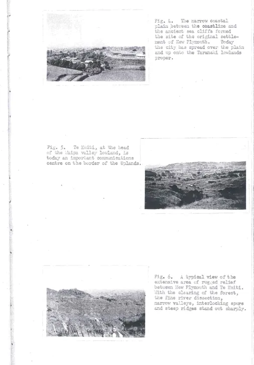
Fi,s' 5. Te Kui-('i, at the head
(if the~raipa valle3T lOi;lland, is
today an iElpor-('311t communications
centr'e on the border of' the U:.:;l::Jnds ..
Fig.. ~_ ~ The nari~Q',v coastal
l:lain :bet-;-.~een the coastline and
the ancient sea cliffs i'orrl1ed
the site of the original settl
e-meYlt ::Ji- I'Jev·j Pl?1i-:.outh. Today
the city 11a .. 3 spread over the plain
ccl1d u.p on-[:,o the Taranaki lo1rllan.ds
J?Y'opel'.
.,
· ~ l · r
!
· !
l ~:
If
11
I;~
'1 \ tFig •
.-5.
A typical vievJ of the : I8.:;ctensi ve area of rugj=;ed relief
oet;;16"en Hew PlYIT10-uth and
Te
I\\rit i.-:iith the clEaring of the forest>
the fin·& rj_ver dissection,
DarI'mv va.lleys, interlocking spu.:rs
and steep ridges stand Ol).t sharply.
[image:18.595.37.547.55.827.2] [image:18.595.42.549.58.785.2]HE
klNCr
COU~TRY
/0 . . IS" 0 10 .:lO 30 "f tl1ile.s
-1 jrtcl, ('/f,,011O 3 S ".,-, I",,,
fbr"I'l't,,',hi
(I.'!'ite (Mrs) (·::;;'i)~9 TOf""on";ki
~~? L.
i:.
't1j""
"
•
~i1:1
!~1
... , JlI
...
~'t, ~.
..
'.... ;!:
~ ~~"
Fi,.'. REGIONAL
HE
TARANAKI
UPI-AND5
10 0 .e) 020 30 ;'0
__ - I Miles
I ipc.h e'r""f!, 35' "'il~5
•
Ne'W
I
Stt-atfol"do I,
~tea
80UN
AA .ES
I
\
\
\
,
,
i
~ Ton8or-ir-o\ ~ Ngour-uhoe
\\~::~~
l
/' ,../oTa'hape
//;/
/, , / ~
--#6;" f
into sheltered l'iater during roue:h 1\ieather.
M.
o.
ca.pable of CO!".lP8tition, ll-:1til tr-l!3 op'3:").ing of the fiain Tru..'1k :"'::12.
1-Aftel~ t:1.E' conpletion of the T.Jellinston-r. el;! Pld'7il.out.h
rclilu.j·Y -j,1 1385, ilirtually 21.11 of th·g tl:'3.ffic bet';'reen Auckland and.
~Iellinston .pa;'3sed through Ye;!l Plymouth c
A line
of 'six others.
TertiarY' era,;l -t~he r3Zi:)11 formed p::;.:ct of the f10.:)1" of 2, sh~.1101·'; se3."
lanr::lo
:'::1 mudstones., s3x.:dstone s a:nd
This
Tile cl, cccrda.nt s1.J.rrr~~i
-s
,3rem-D:;J..lTGS of ~1 la.nd of 10"(,1} relief.
r , '
Grange \ I) believes tl!.e old s1....1.rface
to h3.~Je aeeD il p81.1spla,in" fOY"cI1.ed at <:!, ti:me it.Jhen the sea [::·i.:,'Jod a
pJ.aiD .•
homogeneous rock ~as :ls"l81oDGd an intricat'8 ::.~i'T:3:r pattern. (FiG.C)
Changes in elevati'Jll ,1>Jere res~xmsible fcY' t;18 fOY'::T1:l.tion of ';::,h(;)
)re-for many rules in l ~11d. On8 of t:--i8 13.rgest c'i' these rivers" the
( 'J
cll~a~i~13,zei' \'-1
central divide bebJeen the up)er i}"mganui ,:~nd jI<:jJ:,ara rIver valJ.eys.
(2)
("'\ • ~, I
\
-
'
:~~
.
~el~i~~~e~:·c t;nth~~
~
~~~~(
:
~hi;;
':
5f t~~ ~~;1~
Eei~~ht £':~CL vq,lle;' fl':)or:s ::.:' ridC8-t'J,?S.
'~\I~ Yi(!~[~ogerleO-!_-~=1
-c,I'Ieec
J.':)ck
! I
/0 :10 30
-to
.,...
• • • "- 0Fi,.
8
\ :::
-r:x.
t·--·
FiE, e 9. ?bis vETtical air ~;hoto of \,Qlange .• i~lomona 'c'O'i'lnship and the SLL2:~r~OlJ11d_ing :-?~.~··e2v illl).st/r~a·Ges ·tll(3 I-':irle dis~lectio11 of -[,118 r~e,3ion l-'~T
irlSeCfLlerrt str~earns" Ri.clges ~1 close lJl~,):~d.r:~t/3r Sepal'\s"te llal~r~OvJ
'i::,lle~y·s 0> Tl1e da.r~.:€:1..-<' t:a. :~,·:;:leS clY'e Ei-G!le r scr'llb e-l" s€co:1dal
Jr 1~O Y'est
:;'!'Illose gr:olt'Jt11 l.s 1""!e3,liI1g t/h~3 scars ()f ma.ss mO,\l\SYrte11t of sc,j .. l Q Lit,.tl.e
LIse 5_s :1()l\j- rr.2\C~e of tli.e l~id,ses ' f; fl1..."G:l11:i::1G acrc)s~ tl-le p110to 3,1"")8 tll.6
Feet
0-- I Doa
-1000 Fec;
1000 _
-3000 I-e'er .:looo
4000 F<.ef
.3000--5000 Fe i
J,rooo ~
. 5000 j-ect
Ovc:.R
Fi'Je
10
~ .• 1'"'1 ...
"- . .Iv SYEOtei-:(2)) • Ample
.l \ . JJ 1'1 :l • l- --:,"':.-_~.~:-.t .. I"_" __ -~I.":~('-'}/'j
2.~~V~>
lS,
genera .. . y) 'Gnl:o' 002"J_DSr:,'v _c." ':::::c ,"<:-:<::=-of the fOJ.~sst v2 .. ries l-Jith relief.
(
.
'.! )
:Lnte:c-
-(2) 30 J. G~l:tllier: nCJ..L"'J2,·ces c.:i· I'J(:n·: Zea,le..n.d: A.cco:-cding to Tll01~Yl
t,l-p,l(~~,ite' s (!l?!"ssi~~ic~., -~icLH :r .. ~1~1·1J_5 c·,f -tJ-lE .·-:.s;:':'-ci?,t,ic'I:. cf
Ameri~ .. -: . .1l Ge~gl~2Jnh,::;~".S;~ Vo]::.:. 3~.L 194{~··--·--~~-·~· ~~--~~~.~.
1
l
quickly cc>vers the aY'ea~ Tli.is, in turn, zivBn IJCi.j"- to tbe sruall
""Gr8E' c1.sf;:ociation of the II second.ary fo rest·H·•
ha.s traced, in detail: the. 1ife-cycle cfttB forest oIthe T'arana1-::i
to S-3;/ , there is Ci series Ol plant celI'Jllunities; one t3rpe by its
It H2.f.:' this clima.x:
Uplands in 1890.
Elevaticn a.bove
Indeed, I'Jhen JJ18,lysed separa;tel;y: the physical cbst.? e1e5 do !:let,
1'.'"as 8D ebata,cle. Tracks 1,-.rere :['e1:1 a:1<'3. t:) :':01101'1
a
river valleyto cliL"1b iron 011e l''i:iTSY valleS" into another) over :relentless ridGes,
rising steepl:}" 600 1':·0 1300 feet abcve th.e narr'cl,J, c.llu:vial,!' va.11ey
floors ~ Dense forest hindered progress.
they '!i·.'ere, i'Y'c::;ti.ently J little more "~ha.:!.-: canals of 21ush.
ItCist env(~1oped ~;he valleys at night and, in v.r:Lnt er, (;fte!'~ P E"rsisted
The noise of JT£t,~;~: ]!lClve:nEnts of :;l C2:'8S cf hillsi,j.es;
DUl~ing the sUD.:.'l£ r , placid
stre<:-lT.S;, E8anderint; peacefullJ throtl.zh Itr;cu,riEl.nt for'est) bstr2.yed
NintET.
P.~raQ.o~ical13;-; tJ:e
pl:.:tin.
this a,rea rem3..ined closed. t.o the :S:;urOY62....11 sct~18r-' u.i'J.til the
comple-:-In order to reach Te Eui-ci, the:re still re!TUlined t.he . .9rcj.:)le:n ci" Cl'OS
s--ing a l'.!-:i.de portion of the Upl3.lJ.ds. 'l'he cOi:~s-i.:,al terl"ace along the
( ~ \
Z:.:~~3, JC() f :)ll}l t118 :;·lIlit,·s Cliffs 0 \ J j
( 1 \
\
.
;irr1e
pOpl.!..Lctl~ DELE1e ..L;:J7Jhitish f0:rmation.
It, i;;;; '.::lacked inla.,.'1d by steep hills ·i:.Jhich
(leri~lre,1 j~<l~o:-rr 'G11~: G15_sti.::nil1g Et~)~;e,J,l~,3l:c·e
Fig. 170 The intense drainage relief aDd razorbac};: na.ture of the :ridges is I'Jell illw;3trated by this vievJ of the cc!.t:,ch
-;::-,snt divide 'oetl'Je.en t.he l'~_ok.s'u-~it:,i 3.l1d Ohura rivers. The
altitn.lC:.e is only about 2,000'
1'1-';0 Vi8\:r5 of the ac cord,::..nt SUTwT'its 1.-J~lich are evide:,-tl~r the
relilllarrts of a la.nd of 1mv' relief,
A ViShf Dea r Tokirinla
looki:1g east.
Fig. 1
3
~ )1. "'vie~-'i lJ.ecLr~ Dou!-;la,s [image:28.595.64.542.19.843.2]Fig .. 1L~. 'The tid.al est.uary of t he Avvalcino river 8..t th.e ljJnl t of the eoa stetl terrace.
: ~
.)
Fig. 15. The Tongaporl.1.tu riveT'
<i
f01..ll~ :.'£'.i1e5 from its Ii.lot'.th at :fu~l ,
tide. TLe fertile alluvium
supports rich pastures but is l iai)le to e}"'i:.ensive f1oodiag.
Note tl18 s cI'lj.b-cove:ced hills r
is-ing steeply- from the flat valle;{ floor.
Fig. 16. The nar~:'ov.J coastal
terraCe between Tongapor'trtu and
llohakatino ba.cked by steep cliffs cut by the sea at an earlier
[image:29.595.67.554.52.790.2]r
Fig .. 170
prililitive
A forest r'efili'lant near ~lait.:ianga sti l l larGely in its sta,te. Altitude ap!..:)]:""0YJ..matel~T 1 :-500' .
Fig. HL The Upper Hoka:u r5ver :Ll1 flood in t.he 1920' s.
of the valley is Btill under tbe original forest 0
(lvII's. L. Tate photo)
Fig. 19. Tbe secondary scrub stage 01. succession back to forest
after clea.ring. Ham.11ca clu.iu.ps CL.'1d br·a.cken ierrl predorJinate and have
[image:30.595.61.534.30.788.2]l::-..nc1 ~
~J-7", .-.~ :,,;.'..:..,.: .• -.J
negotiat.ed be"hrBSl1 101-0[ :-}.nd h3..1f t.ide e
t,·i :J1.1 5 E.:.1.1.c1:; :::.ett,1c:·::n.8!J.t.
Cnl}'" ':::";:1 lOGall]
Indeed~ the sreater
Cliff·s ~
Thus it is l:L ttJ.e i--vcnder
sultcd
J-·:··.·.···1··: · · · '
.,
,
l
;~·
:
'
:
·:··1
~
1
.. '
j -j
.~
J
\i.~.lJ~8~.. v' · :-~.n.d--. t,.... "'1 .. \~-; ·~:-:!--.-:·.... ··-,":I.-~,·~.L·.~.~- ~ <-~_-j --"-' ~' __ '-II.· -• ."_I.:? __ .. I·.J.{,'J_U f='_;' . ";: T.:":.r,~·.,,,.L""·! '.-:'" . ~ ~:~,... ll'~~'('-'~"i"-" .:.}... ,"' ... !....i...... 1 .C-... ":TE·\I. ·;....!..v 1'-'-~... ..J;:j-.._'. ~.. . L'''.\./ - ·1-l;'._~ ,-_c
-.
iIICUY'5j~Ol!S t12~aJJ.1S~ t,I1e 'Te .. ra~r:c:~l-:i 1,:!:~cr~is Q (F'ig e 20:~
.~ .,.
J..v COl'lt·i~lUG(l
15a.
and s ett.lements > notably G.t Earokopa river, Haikawau and the l\1'Jakino
river. The 110kau river 'Has the s:: te of a consid.e~.'able population ..
Se"lreral branches of the Nga:ti-l-ia.njapoto tribe D-Y€d near its mouth and
1m the ri ver va11ey:~~. The nex:t, tHel ve rf1iles to the Pul:earuJ.").e ilpal!,
near the southern end of the vrhite Cliffs, formed an efi'ecti ve bar:rier
of S t.eep raviJ1.2s 2J1d forest-clad ranges, a part from the narrO\v strip
of bea.ch at the Dase of' the cliffs 0 From Hokau to t:he Kat
ik3.ti-03.;'-:3, lipan 5 at the northern end of -c.lle hiJ.1ii:.e Cliffs, t he trai l tl~aversed
C.){.:.'~ 2 t,.::.l 1.1i.lls to
." J ..
c:'.V
LL'L1Cl !) clJ.lt;j.-\..ic.teC. ~b~y
~ni.J.'~s ;;
I
l.-·Ii ~~,b \) e(:a~E~i'Jrlai s'?Mnd}l.ilJ_E IT
PR INC I PAL
I in<.h equals {b rJ'i"e~
I
".;~.:':'.'.if
'it"'. ···: I·!.'·:·:···.
"
_ t:
, ... ':.' ~:
.~f
,
t
·( .
")':
t
(
;
i
... ; •....
g~.
:
•...I
J
:
. ....•
,
.•... \ ...•.. . ;.l ~::,
Fi60 2.1. :._ vertical air phot.o of the ~·~1dte Clif.:Cs taken at, h.::;.lf tide shol,ing the narrow beach e.xposed. Here the Eessenger r&ige
r:'eets the sea in 900 I elii fs. The a ose21ce of the coo. stal terrace ma,de this rar..ge a cI·itical point for la.:.1d travel. Even toda;,-" at
10,(,'[ tid.e J the beach is used as a stock route. The terrace can be
seen re,:o,p~Jearillg at the top of the photo.
i'GS pr::'.-l!.'L.l."Glve state.
Fo}, ... est still largely in
(N.Z 0 Aeri&.l }ia:.~p ing photo)
; I
'i . " .,1 !I ~.
.,
t
I
t
1
I
I
t
.
~
:
'
i
'
:···'·:I·
i
•.. : •. ' ..•...•....
.'. '!
".;;!C;
~
tf
'
J
i
.
i
'
• .;.: •....••
~ ...
l
. :. 1.·.· .. ·:·:1::
.
j:
Em effective barr-ier aga.inst inc'J.rsior:.s b;~r hostile tribes. A fel'{
Eaori paths led. through :':;8 Uphncls 2...11.d conD.ected scattered vi l lages
\":ith the popuJ.ated coast. (Fig,,20) ~ The Hokan river ":8,5 n.avigable"
Habi~1e trail b}··3..l1.ched south1r.Je"rds, up the I'.iokalJ.-iti river e~'1d a.CIDSS
the Tafrui-'\;'Jahine ranges ",hich form :,he divide bet'iJ'een the catchment s of the headwe.ters of the :r.~oka.u-it::.l and Ohura rivers 0 The trail CO
D-tinned xross the upper 1tJaters of the OhtU'a river to KavJakawa, fo110 w-ing the TaringamuJ-.u d:iTer and the 'I'uhlla ranges to the sou,thern shore
of Lake Taupoo A bl~2...'1ch of the trail lay along, but, not in, the
valley of the T,va:L1{aka river to Nihoniho, on the Ohura river 'I-'lhence it
travelled so-tJ.th-eastwards to conn.ect vd.:i:,h the Tapui-t'lahine trail. .A
second i.."llaf1.d trail, the Tihi-manuka, ran from the coast at Katikati
-aka "pat!, along forested ra..l1ges to the Tangaraka gorge, near the modern
Ohur?~ road route; across ranges and river valleys to the lrJ'anganui river
at Ko,iro; thence along the river ba,1'lk to the present site of
Tau-marunuio A third west-east trail across the Uplands to the Upper
'Yianganui river was the Taumata-mahoe track, which, begin.n.i...'1g at Onaero
on the· coast, fol101ved the Urenui river to the Taramouka;u stream, a
tributary of the Waitara river. Here, it was joL'1ed by another trail
from the coast following t he north bank of the Waitara river. The
combined ¥J.aori trail continued inland across the Iljaitara river at
Purangi; climbed the dividing ra.1'lge and descended into a tributary of
the Patea. ri'V'er l'lhence it ran, in an easterly direction, into the
valley of the l.\Tanganui river.
These three routes were the only ones affording means of access be
-tween the sea coast and the interior. The Maoris used them ma.iP~y as
a means of refuge. Long distance movement of goods, except those of
very high value,'played little part in the Maori economy of Taranaki.
The Patea' river valley and the ~vanganui river provided tW') routeways
L'l1to the interior from too South Taranaki coast. The potential value
1
~
l
j
·.·1'
't 1.': ' 1·
1
t
'
l
1
··:.·
I~
·
···
·i":
.:t.
i
bearly as 18690 tlNative tracks a s a rule follow the best lines of the
count ry but a re generally cap3. ble 0 f being improved in detail.
Inas-much as bridges are rarely thought of by the natives, considerable
detours are often IJIade to a void a stream which :rJight be covered with
the exercise of a moderate amount of mechanical ingenuity. Swamps
too are 1D und a round which might be rnade passable by a small amount of
1vork Ll'l draining. 11 (1) Along the lines of the trails, many secondaFj
roads
m
ve been laid$ connecting the main through routes. The important Haori trail along the coast corresponds, closely, vrith tb.e presEntroute followed by the main coast road bet,,!een Te ICuiti and Nevi Ply-.mouth" Above all, the trails proved indispensable to early surveyors 3.l.'10.
ex-plorers.
Unfortunately the Maoris, having no vehicles or draught animals,
formed only narrow tracks 1>Jhich 1'Tere useless as a means of serviCing
the settlement c f I'je-Vlr PlylIlOl.. .. th. Fror:.1 18L~ 1 to 1890, il:Ll"t'...l.ally al l
,::8a. co:rm2u.:.'1ica.ticm \fjitl:l ~'lellinsl:;on declined
Cobb! s coach provided the first reg'ul::> 1:'
roac. connection betv!een '\If.ll1gan1.::i and Nev.! Plymouth, early in 1871.
The opening of the ':Jellington-Ne1rJ Plymouth railway: :L."l 1 1385, com.pleted
the diversion. ( ) i trade from sea 1:D land e In cO:'1trast, sea trade vuth
Auclclar.d increased Jecause New Pl;y:mo'L1th became t~-:e ~c:canshipment centre
for the rail &"1d S '33. through :coutj8 of North Island ·c,rade. The river
port. of Waitar3, cOID.TIl2.l."lded a (';onsiderabJ.e sha.re C£ oc)th imJard an.d
out-1,Jc.\,rd shlppinz c· RegLll::>. :c., services 1"wre in OpeT'B,t-iOl1 to Onehllnga,
113[;12..n and Kawhia 1·\lhil8 lYloh:au and AVJa.kino ("Tere 13,rgely supplied by s sa"
The constru.ction of the artificial harbour at NeH Pl;ymouth concentrated sea traffic through tl::.e ne'V,T port.
The year jg90 marks the peak period of the coastal sea serviceo
;:the complet.ion of the Nain. TruJ.":.k railway.~ J.n i 908, :!..ed to a rapid decline
in the coastal ~rade. Heduction of traT,relling t ime bet1tJeen Auckland
···,··_1.-'
,---
[image:39.597.53.543.54.785.2]-I
1
Fig .. 22. Coastal shippi..l1g "vas vital in the -early yea:rs of the
settlement of New Plymouth. Here pictured is one of the coastal
vessels 1 • .;hich supplied the Eorth Taranaki set"clements such as
r-lokau, Tongaporutu and Airlo.kino, tied up at tte river port of ~vaitara ..
The opening of the main north road for all~1Neather traffic in the
late 'tirmnties broiJ.gh
t
an end to this service.-
I-,
I
'~
i
'.j1
1
-' I :
.:,
1
!
l
1
1
•. '.ll.··· :.1 .
..
,
I-"ft
1
t
f
J
I
t
··
: ;~~
-':.:
?
....•... !J ... ' ... ' ... : 'I~:': ...•... :.···1.)
...•.... . • :: .• :). ,., •. i,: ' ..•.
..
~>;t
. ··.·.1.'.; ..
·:-lt~
18.
and Wellington t.o eighteen hours, instead of two days, meant cheaper
freights "irinile the prospect of trading with the new settlements
along the railirla;y helped to divert traffic from the sea to the land.
The clearance and maintenance of a channel through the bar at the
en-trqnce to the lVIanukau harbour was too great a task to be economical 0
However, lack of other means of transport necessitated the
continua.-tion of the sea service with the North Taranaki coastal settlements~
It vvaS not until the economies of the motor age occasioned an
all-weather, coastal road that the sea service was abandoned. Difficult:ie s,
associated principally ~rith the physical nature of the country,
pre-sented such a road Lmtil the late i920tso The signifi cance of the sea,
during the years before 1890, cannot be exaggerated • Despite its
' . \
fundamental role :Ln the early progress of Taranaki, it could not
com-fB te wit h the rapid and reliable services v.Jhich the rail and road were
to prov4....de.
The years betwe~n 1890 and the opening of the l~in Trunk railway
were those of transition :Ln means of tr~nsport; coastal sea
comm_uni-cation reached its maximu.m. development and bega.YJ. to decline; the
survey of land routes a cross the Taranaki Uplands vJaS inaugurated; a
beginning was wade on the construction of the coastal road and the
in-land road and railway. The principal feature of the period, h01..rever,
w-as the completion of the II/lain Tru..'1k railway with the construction of
~he Te Kuiti to f~rton section.
Te Kuiti is 120
wiles,
in a direct line, from Marton aCrossthe
eastern Taranaki Uplands. . Although the railvvay had reached Te Kuiti .
by 1887, twenty one years elapsed before the line was completed.
It was the idea of a Nain Trunk railll'Jay to link Auckland and ~.1Jellington
and the conviction that without such a li..1'1k the rTorth Island could
never begin to realise its potentialities, that drove the railway
con-struction on :L.'l.. t.he face of financial difficulties ~ a twenty year old
native question~ the deepest economic depression t~1e COlmtry had yet
knOl..zl and a succession of engineering problercs "u.nequalled on 2.n:/ <Jther
lirle in the cO'Lmt ry • \fiith an ullsolved nati.ve problem 81":.d a central
upland. block which must be crossed, the choice of a route for the line
a. gain , as each important s8ction. l'JEl-S nearing completion 0 11 l'eport ~
itH··itten in 1872, discussed three possible terminals a ft.er t.he lin.e
( 1 \
Ie it N ga. rUcl,\\Tahia • I / The j:,a.ilhead fina.lly decided Llpon IVas 2~t
rihikihi, tv'TO miles south of Te A,·vamutu. The opening of the section,
in 1880, once again l"'aised the problem of altern-J. tive routes. Bearing
in rnil'1d the future connection 1.nth \[vellington, the central and more
direct route, west of 1ske Taupo, VlaS regarded as the obl:~ous choice.
One alterr...ative inIaS to head loVestward, to the growing
settle-ment of Ne1,v Plymouth and thus utilise the railway already const.ructed
between New Plymouth
aPn
';"Jellington 0 The sug;ested route along thecoast from Awakino to Haitara 1t.."ras abandoned early because of t1riO main
factors; the nature of the country vvhich was some of the \·.;orst that
had been surveyed at thai/time ~'1d the fact that being a coastal route
it could only open up land on one side of the railway. A more favoured
route through Taranaki INas via Ohl.U'a to Stratford. A complete
alter-mtive was to avoid the K:L."1g Country and its native problem altogether,
by carrying the line east of Taupo to the JYIanawatu river. (2) The
main purpose of the railway under Vogel is public works policy was to
open the interior for settlement. It was desirable t hat the railway
should give access to fertile areas, especially, i f in so dOL~g, it
could a void t.he upland block. The preliminary survey of the three
routesJ in 1882, disclosed several important facts. In neither the
eastern nor the Taranaki route V.J as there much difficulty -vri th the l'4aoris.
The nature of the topography presented the greatest obstacle; in the
case of the eastern route, the barren pumice region of the Kaingar~
plains offered little to prospective settlers at th3t tiro~. The full
survey of the central route 1,vas done by John Rochfort, despite l'1a.ori
interference during his exploration through the heart of the King C01l.l1try.
The work was completed in 1884, after ten months of exploration in
\vhich razorback ridges, steep ravi.l1es and miles of trackless forest had
required as great a fortitude as the rifles of threatening lJiaoris.
(1) Appendix to Journals of .the House of Representatives; 1872, D5: po5
!10hAU Rour~
-STRATFORD RouT£. A\ X " X X X
NAPJ£P, RouT£. OOCOCeooeco
/ '
I / - - "
jMOHOU
J
/
/ '
/ '
-- - -o-tJt-enu;
...
... o· • • ••••.
x
X
x x
" "
.
•
I
{I
20.
From the viewpoint of settlement ~ the cent2:'z.1 r cute1:J'as most
A"9pro:;cimately 80::; of the
land \'1[2.S classifie da. s ploughable, though.:; c.t that time, it ,'.las o,e_1
fern C01.lnt I'Y 1,-ri,th ClUlllPS of k2.hikatea (Podocarpl.i.3 dacrydioides) in
the valleys .. (1) As a result of the investigations, the central route
-\Aras adopted, iodth the belief that it iiJ'Ould giv~a::ccess to the greatest
area of land suitable for settlement and followed the least costly
line a cross the upla,nd block.
The rate of construction varied considerably.. The first twenty
six miles to 'I'e Kuiti vlere finished ill t'tvo yea.rs; in the next
two
years, onl;)T a third of tba
t
distance ioTas cover-ed. Topographicdiffi-culties played a large part in the retardation. As far as Te Kuiti,
the line followed the valley of the, ~'Jaipa rivere ~vith the
penetra-tion of the Uplands, steeper grades, high v~aducts, sharp curves
and
long tup~els presented greater engineering problems. l{oreover a
large part of the work vJas done d1..lring the depression years of the
late ~ighties and earlylnil~eties when finance was not readily
forth-corning. The rising price level, after 1895, alleviated the difficu..lt;/.
Thereafter, lLDtil the completion of the line, the retarding factor
was the rugged relief. The Raurimu spiral exemplifies the remarkable '
engineering feats occasioned by the difficult terrain. The railway
climbs 2,160 feet from the river side at Taumarunui Flat to National
Park Station on the WaL~rino plaino The lLne
runs
in an ascendingspiral, a. complete cil"cle and two loops 't'l-:ith t"i.vo tunnels. (Fig.24)
The railway vas the key factor in the opening up and development
of the King Country. Thousands of acres were nade accessible for
pastoral settlement; timber 'milling and allied industries became the
main feature of the King Count~-'s economy. The clearing of t~e forest
from the alluvial river f1a.ts and gentle slopes was quickly followed
by the surface sow-i-J,"1g of grasses on the slopes al"1,d the ploughing of the
valley plains. Present tOV>.lJ.1S, such as Taumarunui and Raurimu, ltV'ere
originally railhead towns, from which settlement expanded as the forest
was c1Bared. Sheep farming, LD association w~th the fattening of
cattle for the Auckland Freezing (rJorks, became the major farrr..Jing in dtist,ry •
(1) A. to J.; 1884, D5: p. 75.
i
(
1:;
~. :
'---.- .. --
---'.' ---'--- - - - -- -.. ~ ... .,;:.-.- -. ~.-.-.---.---~.---,-~. " . ~ --,"-
::;=-:
J
'
··.1,.,.·.·
. '
i
'-1
"'
:,~\1
'
. r: . ,.
.21.
Settlement i::1, the Oh1..~ra: district Has also pion.eered during these
years but it i,.TS,S handicapped by tVJenty miles of umnetalled road 1\b,i ch
separated it from the railwaye The road 't"as impassable during the
vvinter months J a factor 'lArhich prevented rapid development on a parallel
'tilth other J.l.1ain Trunk settlements e The inaccessibility of the a rea
was responsible for the commencement of a railway line from Okahillcura,
on the ~1ain Trunk, to Ohura in 191 i " The district developed a co
mmun-ity of interest i~d.th the overseas port of Auckland, not only because
it gave the easiest &~ cheapest means 6f co~~ication but Auckland
capital and organisations had nurtured the settlers. As regards ac
-tual dis tance, the Ohura area, includLYlg TaUL'"'1arunui, was closer to
Nell'[ Plymouth b"L.-t betvreen them stretched the topog:::,aphic barrier of the
Uplands. The distance to N81-J Pl;YTJlouth is less than a third of tha t
to Auckland and yet, the trade of the Ohura area was 1 .. rith Aucl:..land firms I)
The barrier to the south-l,vest vras no myth and it l'Tas not until the
Stratford to Okahuku,ra line 1'laS opened in 1932 that New Plymouth began
to dra-If; the trade of the area into its hinterlando
The ilI1.portance of the }IIain Trl.LYLLc line, however, does not lie
solely in the new settlements to ~mich it gave birth or to the tirriller
resources that became accessible for milling. After 1905, the flolv
of settlers and trade between Auckla..'1d and hielli.ngton was no longer
hindered by the frequently rough sea voyage from Ne~l Plymouth to Auck
-lalld. Tbrough traffic by-passed Taranaki, in general, a.."1.d New Pl;ymouth,
in particular. Taranaki had gain e d a land route to Auckland but it
"laS a circuitous rail journey, via r,fu,rton, al1d occupied brvo days,.
Such a :means of transport did not sclve the problem of a northern outlet.
Coastal vessels continued
to
service settlers along the northcoast; the quickest and cheapest means of reaching Auckland from New'
Plymouth was still by sea, across the perilous bar of thE Manukau
harbour. The diversion of through North Island traffic to the Nain
Trunk railvlay brought a decl ine in the entrepot trade of the port of
N e1nT Pl::l]EQuth. T1..e,f...,- p·asr':np' oJ:> 'T'~ranal(i b,y "'bo rail' .. ""v re Pll1ph"'sJ'zed
!.1 VUf;/-_ 0..l.._ 0 ..i. _d. _ , J LJ LV ... __ If'olo,ej ' _ - _ .... _~-_c;.. .. , , '
its isolation, especia.ll.y from northern settlements. Farmers along
;1'
j
J
_·· .. '.:·1·: ... ',: .···
..
:~
····:··.1·.:.7 1 ...
.~-.,
22.
of settlement ~ v,rere still isolated for more than siJ~ months of the
ye2 .. r whereas -:1-'3 n8\-[ settla'1snts in the King C01..mtr;y possessed, f:ro!r1.
the time of their foundation, a raiIHa;y" direct to an overseas port G
This si tua tioD ,more than anyth:L'1g els e, stressed the necessit.y of
providing these isola ted settlements 1>rith an u..n.interrupted means of
access to New Plymoutho Co~~ercialinterests l~Llforced popular
opi.nion, in the desire for go.'Jd cornmu..nication lines ID ich would not
only provide transport serv-lces but 'lfTould also attract new areas and,
thus, enlarge the hinterlar.d of New Plymouth. ~~e opening of the
port of New Pl;ymouth" in 1917, fo r direct overseas shipping accentuated the validity of the case.
The adoption of the central route for the Ivlain Trunk raihray
re-sulted in diUtisfaction between Auckla.f1d and Taranaki, on the one hand,
and Wellington" on the othe r. H01rleVer, l\'"hile Auckland lost interest,
Taranaki did not forego the possibility of a western rail cOlliiection
across the Taranaki Upl&~dso Families had taken up sites inland from
stratford, on the ,understanding that it was t8 be the rail ju..1'1ction of the Ivlain Trunlc vri.th the New Pl3'lnouth-~·lellington linec After 1890,
a considerable number of settlers moved, eastwards, into the
irJhang-amomona cou..ntry, into the true Taranaki Upla...ndse During the next _,
fifteen years, axe and fire removed the forest from even the steepest
of hills. English grasses, which were som in the \varIn ashes of the
aut~~ burn, replaced the protective forest. The rejection of the
~ aranaki route for tre Nain Tnw..k rail1nJay left the settlers virtually
without·hope of removing their isolation. Some success had been
ob-tained in securing road cowmQ~ication but, for over six months of the
year, the ~'Jhanga.Tflomona to Stratford road 1:lTaS an impassable sea of mu.d.
The cost of trB-nsport amounted to 50-100% of the price of goods L.'1 Stratford. In the SlllTIiller of 1900, the charge for carting goods, by
road, to Vf..l'18J.'1 gamomona l'laS £2. 1 0. 0 a ton, C ompa. red 'Wit h
£3.
9.
0-'- . . -'- (1) h ·t ' b l ' + -'-h
1~
a uon, 1111tn.Tll,.,er, 1rhenever 1. was POSSl. e '"Go gev v_::cougu. The
result 1>Jas the proposal by govern:LYlg bodie s in TC'~rana.1:i, for a light
railway into the area, from Stratford, to provide facilities to service
-l
•
~···.··'.·.···,···
I
.. ··.
~
..• : .... ' ..,
:..~ ,t
, .
't:
_ ..••.•••
i.·
I~
.·
..•.•.~-".~ ,
:
1
)1l
'
I
.J l.. J t ...
;
1
'
:S
,
.
f
t
.•
~
~
i
.
~
•. · .•. ' ...
:.·~.·
•. i.·.J: ••..J
't',:";
',",:
23.
and TI!aint.3.-in t.116 cOJT.:2Hinitie s .. ThE7·tle-\relopment of t.his idea, into
, an urge for a 1'2,i l connection "{.Iiith the l·12.in Trunk and, thus, a
:coute-\'va.y across the Uplands, forms the topic of -che Iollc1t>!ing chapter. Basically, the problems assoc:L-:t ted 1",-i th both the inland :."Oad 8;;:J.d rs"il
-\va;sr resolved themselves into the difficulties of penetratiilg the
top-c gr-aphic barrier.
Sett·12ment. had also expc.~nded north-II'J'G,raS ~ along the eoastal
lcn-.r-lands to Puke~~,!'l..t~1e and inl::md, up-:',he Uriti valley tOGl16 foot of the
Nesseng6l:' re,n,ge ir,rhich S8)2,r·ated. these fa.:cming dis tricts fn:.l1n tho S9
northwards of 'I'e.ngaporutuo '}:):'.e inadequ_Clcies of sea com.mmications
in 1890.
About the sam.e time, a. bridle pa,th lila.s opened
from /'~l"iakino, eVer the Tau:n..atamaire hills al'10. ",long. the up~)er £-1:0l-;2U
valley-, f;ivil1g 3.c::ess fr-oJ:H the c.oast to Te Tuiti and the -;!Is.ipa d.ver.,
The only portion of the route1:etvlee.n 1'e l~uiti 3.nd Net'" Plyr:lo'..lth open
'GO vJheel traffic '\!"as Il"om Nev-J Plymouth to Uriti - a distance of only
thirty miles. The section haS 7netalled before the beginning of the
The e.x:perience of the early pe riod of roadbLulding
t
~
.,
illustr':-lted the difficulties I.,rhich would be confronted in future 'liJorks.
cuttings, through the I!papaY
forma tiol1,1 proved to be unstable;, due to the continual i!Vater-seepage
and the long :geriods of he.av-y- rainfall; maintenance V\Tork had to be
continuous a By 1900, the road to Hokau, over JYhmic Messenger, 1nTaS
ii:
open for wheeled traffic, during· the Sllil1rller months. It reITl.ained purely
a sumner road li.l1til near the end of the 1920' s" The tidal Tongaporutu
and Nokau rivers 'tv-ere cro ssed by means of a punt. ~vith the
indiscrim-ina t.e felling of the forest 'tvithin the I i ver cat ctlment s , an increased
run-off resulted in the rapid rise ~~ river levels, du~_ng heav;y rain
-fal l. Even in the s~~mer, coromunication v~s often L~terrupted by high
floods.. A t the outbreak of the Great vvar, there 1nJas still no regular
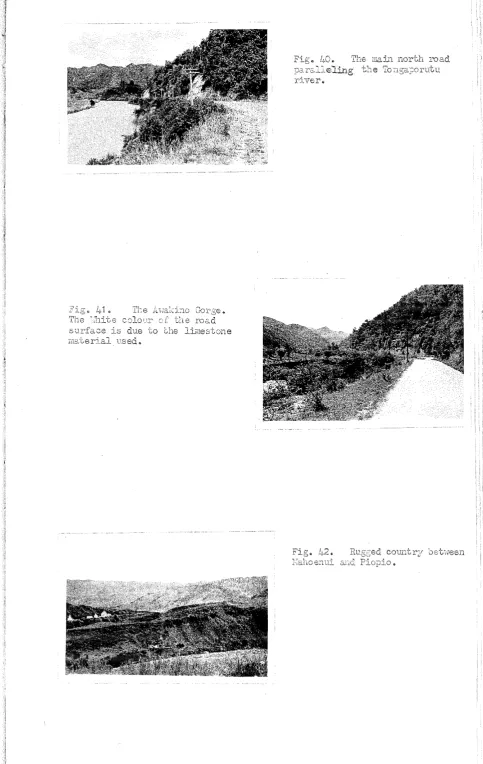
Today, the coastal road pro~~des, not only the w~in outlet
north-1,,,,ards from Ne,'\T Plymouth, but is an important section of a main hight"lay
betwe en Auckland and Uellington 0 The period after the Great \;Jar
·t\Tas an era of irnportant road construction.' The popularity of the
motor car and motor lorry meant that all-weather roads vlere a necessity ..
In the days of the "ho rse a.l1.d buggytl, a cart could travel on the mu.d.dy
road:?&"'1d provide servicable corrnrtUJ.'1ication bet"l,1Teen settlements vi.nich
,.vere in clo se proximity. The a dventi of the automobile age' made
it
possible to cover long distances, in a comparatively short time,
pro-vided the roads lifere suitable. As in other parts of Nel'" Zealand, the
automobile, j~ Taranah~, gave n~w life to, hitherto, isolated centreso
!v1oreover, i t gave imPetus to the roadbuilding era I,hich continues today;
an era., which has seen the penetration of the physical barrier of the
Taran.aki Uplands by mod ern communi cation lines. The term "backblocks"
is nOlif> rarely applicable. h7J.1ereas the ride from Te Kuiti to Ne1v
PlJ"'I!1outh, by horse and coach, required tvlQ strenuous days in 1914, nmt{
the 105 road miles form a comfortable journey of three hours by motor
car.
Changes in many forms accompanied the neN modes of tr&"1.sport 0
Physical obstacles ceased to be insuper.s.ole and beca~me only rele.tive. The;: vJere· penet:c2.ted by modenl r02.ds and rail1rlays} in order to 1X.1ite
the T2..rana,:d lo·\t,rlanc.s. The econolnc structure of 1:0 -ch areas 'hras altered and impr'oved. The hinterland of Nel! P1Y:!louth e~ct,eYlded as comrmmication IL.les were constructed into areas, Ilvhich had, preiriol.ls1:y,
Jooked to Aucl:la.nd as their o~v-erseas port and. :rna.jor c01ITr:ercie,l centre.
[~eneral Th,s d evelop!EEmt of the y:ceserlI, C021lIlunication P2:t.t,.:;:;:--n in Tara.r:aki: clearl:}" erEphasizes the legacr of "CDe past.
Progress and isoJ.ation are inco!J1.:.)atlble in the D:resent age of rapid
t},.'),."'1.sport. and ccmrrrunica.tions 0
--24.
CHA?TE2 III.
as 3. Communication hUle.
of settleiJ.len'~ J New PIYTaouth could COEIITmnicata with the rest of N61rf
Zealarid, onl: ~e seao At one stagej the colony 1iJaS described as
rrlaL.'1tai.ning a precariolJ.s e:xistence, l'Jith the sea in front of it and
the forest 3J~ld hostile Ymo:ns behind. The completi.on of th e Nel'J
on the B2.in stl~e'3.m of north and south traffic it"/Ghe island 6 ~iEth
the improvement of the port facilitie ~, expeditious transport between
... o.uckland and Hellington, by combined rail and sea, v..ras offered&
Hm .. jever, by diverting tra.ffic thr01J.gh the centre of the island, the
Main Trunk railv,[ay forced Tar&'1aJd. ,again ,into a backwater in the
North Island traffic stream. In ! 900., there was not the least doubt
that ~~e greatest opporttmity of removing the isolation lay in the
proposed rail~'lay connection between New Plymouth and the northern
portion of the Nain Trunk railv~:\r. The realisation of this project
appeared to provide the best hopes of an effective northern outlet.
In 1870, the suggestion O+' .L 0. .., North Island Hain Trunk rail~vay was
corrunonly mooted. Duri..'1g the next few years, the construction of the
hiellington-New Plymouth line vJaS begu..n a..'1d, utilising different
sec-tions of this surveyed line, alteITI.8. tive routes for the l1ain Trunk
railway were prcposed. ThoSG through the Taranaki Uplands lITere
serious contenders. u.. ~ early as 1875" an expedition set out from
t1:'1 e forest-enclosed village of Stratford, Iifith the intention of
reach-mg vihat is n01'[ Te Kuiti, in order to obtain a Imowledge of the land
and report on possible road a..'1d rail routes to COTnlect with the Auckland
district. Difficulties encountered in the extremely rough a..n.d
track-less country proved too strenuous for the e:xpedition ll1Thich vias forced
to emerge on the coast, near ~lount Nessengero Exploration parties,
dur:L"lg succeeding years, met i-vi th mo re succ ess 0
S.election of the route betvleen I"Iarton and Te .A:v.lamutu became a