Abstract— Location based services are becoming an emerging market due to technological advances achieved both at GSM phone operators and the multimedia nature of the mobile handsets. In this paper, a new methodology of mobile positioning integrating both GSM network using signal strengths and GPS readings in the light of an assisted GPS based approach. The methodology employs an extended Kalman filter approach in which the stochastic errors related to various measurements are appropriately characterized and modeled. The methodology uses Netmonitor software to retrieve network information including signal strength and cell-identities of various base transmitter stations (BTS). The distance from the mobile station (MS) to each BTS is therefore determined using Hata -Okumura radio propagation model. The different distances and the GPS readings are therefore combined in the framework of extended static Kalman filter. Once positioning is achieved, a .NET like application is implemented to access the Microsoft MapPoint Web Service, via the Internet (http protocol), which visualises the mobile’s location on a map, finds nearby points of interest (POI) and computes routes between them. In order to demonstrate the feasibility of the proposal, experiment is carried out in Birmingham area and compared to the result yielded by the commercial software of MobileLocate Ltd. An accuracy of less than 70 meters has been achieved, which shows substantial improvement over standard Timing Advance related techniques and the commercial software.
Index Terms— mobile positioning, Kalman filter, Netmonitor, MapPoint server.
I. INTRODUCTION
Since the emergence of mobile computing applications, the development of location based systems has grown drastically. This has been motivated and encouraged by the E911 standard. This mandate required mobile operators to provide the Public Safety Answering Point (the emergency call centre) with the geographic position of 911 wireless callers, which forces the mobile positioning within 400 ft of its actual location 67% of the time [4,13]. For this purpose, several positioning techniques have been developed and investigated. These range from techniques using only the available infrastructure without any
changes to those actually requiring some changes. The former class of methods includes the Cell Identity (CID) in which positioning is performed by finding the cell (geographical coverage area of a base station) the mobile is currently in . Another approach uses the timing advance (TA), which is based on measuring the round-trip propagation delay of the signal transmitted from the base station to the handset and back to the BTS [2, 3, 5]. The latter allows the user, given the speed of radiowaves, to determine the distance between the BTS and the MS, thereby, when several BTS were used, the location of the MS is determined as the intersection of the underlying range circles. Other methods use signal strength as received by the MS from the base station, which using a propagation model [1, 7, 8, 10, 12, 14] is transformed into distance from MS to related BTS. On the other hand, in the class, which requires changes in cellular infrastructure, one distinguishes time difference of arrival (TDOA) and angle of arrival (AOA) [7].
In contrast to cellular based techniques, GPS based technology uses GPS satellites, which, through a GPS receiver, the position of the MS in terms of latitude and longitude coordinates is determined with an accuracy of less than 10 metres. However, usually, such estimation is only plausible if there is a clear line-of-sight to at least four GPS satellites. This reduces its capability in case of dense urban-like environment or indoor environment. In order to deal with such situations, the idea of Assisted-GPS (A-GPS) has been acknowledged as a promising technology for future location based systems. The basic idea in A-GPS is to enforce a fruitful combination between Cellular network technology and GPS signals where an assistant server, which can be made available via, for instance, a network, helps the GPS receiver to perform the tasks required to determine position estimate. The resulting AGPS system boosts performance beyond that of the same receiver in a stand-alone mode. One of the main purposes of A-GPS is to provide municipalities with location-based emergency phone service, such as E911 service. Another is to provide mobile carriers with
end-user, location-based services such as a turn-by-turn navigation aid
Finding the position fix using the network can in fact achieve reasonable accuracies of less than 50 metres, based on the results of our previous work in [9]. Therefore, such network-based can be useful when GPS is unavailable. This paper advocates a fruitful combination of GPS positioning and cellular network-based methodology through conversion of signal strength into distance measurement. Especially, Hata’s
Combination of GSM and GPS signals for Mobile Positioning
and Location Service Using Kalman Filter
S. Hamani, M. Oussalah, P. Hall
University of Birmingham, Electronics, Electrical and Computer Engineering
propagation model [1, 7] will be used to determine various BTS-MS distances. Next, a Kalman filter approach will be developed that comb ines the different BT-MS distances together with GPS readings from the GPS receiver. Once the positioning is determined, through a connection to Microsoft MapPoint server, mobile location services, including, map generation, itinerary search, identificatio n of points of interests, among others, can be enabled. An experiment is carried out in Birmingham area to prove the feasibility of the approach and comparison result will be provided.
Section 2 of this paper provides a general overview of the developed system. Section 3 details the Kalman filter approach. Section 4 details some experimental results carried out in Birmingham City area.
II. METHODOLOGY
The process of finding the location of the MS using the cellular network, and thereby enabling further services through MapPoint server, involves several stages.
A. Determination of Base Station locations
The determination of the location of the BTSs is accomplished using information available from the government website www.sitefinder.radio.gov.uk, which updates the location of GSM and UMTS base stations throughout the UK. It is therefore possible to measure the latitude/longitude positioning of all the surrounding base stations.
B. Signal strength calculation
Using NetMonitor software at the exact reference location, the strength of the signal received from the serving base station, as well as neighboring base stations, can be measured. Indeed, Netmonitor allows determination of the Cell Identity (CI) code of each BTS communicating with MS. By forcing the hand over in order to communicate directly with a specific CI (or BTS) using the channel number of such cell as pointed by the software, Netmonitor also allows us to display the received signal strength (Rx) transmitted by each of the surrounding BTS pointed out at previous test. See [9] for details of operation.
C. Distance calculation
The distance between each BTS and the handset can be determined using one of the empirical propagation models. We focused in this paper on Hata-Okumura propagation model [7], see [1, 9] for an exploration of alternative models. Basically, the model provides an expressing of the path loss of the signal transmitted by the BTS (Tx) (known through sitefinder) and received signal at the MS receiver (Rx), retrieved using Netmonitor, as a function of the distance between BTS and MS and the carrier frequency f, also determined using Netmonitor displayed parameters.
More formally, the Hata-Okumura model defines a parameter
a(hM) to be the mobile height correction factor or gain (dB). As a
result Hata subdivided the urban environment into large and small/medium cities.
For urban areas the path loss is expressed as follows:
(
)
(1) ) log( . ) log( 55 . 6 9 . 44
) ( ) log( 82 . 13 ) log( 16 . 26 55 . 69
d h
h a h f
Rx Tx
B
M B
− +
− −
+ = −
For suburban areas the path loss is expressed as follows:
(
44.9 6.55log( ))
.log( ) 2(
log( /28))
(2)) ( ) log( 82 . 13 ) log( 16 . 26 55 . 69
2
f d
h
h a h f
Rx Tx
B
M B
− −
+
− −
+ = −
a(hM) refers to the small/medium gain factor and is given by:
(
)
− −
− − =
city um small/medi for
, 8 . 0 ) log( 56 . 1 ) 7 . 0 log( 1 . 1
city large for , 97 . 4 ) 75 . 11 log( 2 . 3 )
( 2
f h
f h h
a
m M m
hB stands for height of the base station (m). hM stands for height of the mobile phone (m). d stands for BTS-MS distance
The carrier frequency f is determined by
f = 1805 + 0.2 (CH-511),
where CH stands for BTS carrier channel number as displayed
by Netmonitor software.
Consequently, as all parameters are known, expressions (1) or (2), depending on type of environment, allows us to
straightforwardly determine the distance d from the path loss (Tx-Rx) expression.
D. Mobile Positioning Location and Location Based Services
Once the different distances from the MS to the surrounding BTS are determined as in previous step, these distances are integrated together with the GPS information of the GPS receiver using an extended Kalman filter to determine the exact positioning of the MS in terms of the latitude/longitude coordinates. The detail of the Kalman filter is detailed at the next section. Thereby, once the location is known, a connexion with MapPoint web service SDK version 3.5 enables the access to mobile location services like map building, route tracer, nearest points of interest, among others.
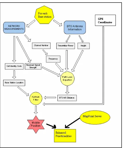
The general scheme of this methodology is illustrated in the block diagram shown in Figure 1, which summarises the tasks that constitute the entire positioning methodology.
Hata-Okumura model allows us, by integrating the antenna characteristics and the retrieved mobile station characteristics, to determine the distance from the bas e station to the mobile station. The above process will be repeated for each base station. The obtained distances will therefore be integrated together with the GPS reading to yield an estimate of the mobile station in terms of latitude and longitude coordinates, which enables further location based services functionalities through connection to Microsoft MapPoint server.
Figure 1. Block diagram for the general methodology
III. KALMANFILTERMODEL
A. State Model
Let k k k l L
X be the vector representing the position of the
mobile station (MS) at time k in terms of latitude and longitude coordinates, i.e., Lk being the latitude and lk the longitude. As the dynamic of the MS is not taken into account; that is, one assumes when the MS is connected to different BTSs, the MS location is assumed constant when all measurements are handled. This yields a static model in the state. In other words, the state model of the target is given by
X
k+1=
X
k. (3)B. Measurement Model
Two types of measurements occur: the BTS-MS distances calculated using Hata-Okumura propagation model and the GPS readings retrieved from the GPS receiver. The measurement
equations subsumes two distinguished and uncorrelated models.
1) Distance-Based Measurement
Let
i i i l L
B be the vector representing the latitude and longitude
of the ith base station (BTS).
Let Di(k) be the (noised) distance between the ith BTS and the MS position at time k; R is the earth radius (6378.135 km). Di(k) can be defined using the spherical law of cosines as follows:
[
sin( )sin( ) cos( )cos( )cos( )]
( ).(4) cos)
(k a L L L L l l 1 k
Di = k i + k i i− k +ε
Where ε1(k) is zero-mean Gaussian noise with variance-covariance matrix R1.
As (4) is highly linear, it requires linear approximation at the estimate state X, which yields
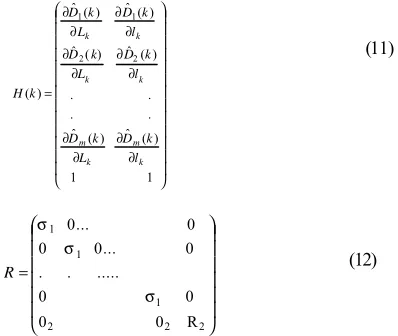
Di(k)=Hi(k).Xk +ε1(k) (5) With ∂ ∂ ∂ ∂ = k i k i i l k D L k D k
H ( ) ˆ( ) ˆ ( ) (6) Namely, [ ] − + − − − = ∂ ∂ 2 ) cos( ) cos( ) cos( ) sin( ) sin( 1 ) sin( ) cos( ) cos( ) cos( ) sin( ˆ k i i k i k i k k i i k k i l l L L L L L L l l L L R L D [ ] − + − − = ∂ ∂ 2 ) cos( ) cos( ) cos( ) sin( ) sin( 1 ) sin( ) cos( ) cos( ˆ k i i k i k k i i k k i l l L L L L l l L L R l D
As far as the R1 estimate is concerned, one should notice that R1
should capture the overall uncertainty pervading the distance measurement. In fact, due to technical specifications reported in [6], the estimation error, due to noise and interferences, must be in the range of
E=∆/4+λ.∆/8
with ∆=1108m and λ lies within the unit interval and accounts for speed of MS. Accordingly, Pent et al. [11] driven a probability distribution of the noise with a variance parameter
+ + ∆
= 2 2
1 2 61 1 λ4 λ4
σ (7)
So, for a single BTS measurement, R1 becomes one dimensional
vector and coincides with (7).
2) GPS-Based Measurement
Since the GPS receiver is incorporated in the MS, so its location is explicitly linked to the MS location, up to noise measurements. This yields:
d(k)= Xk+ε2(k) (8)
Where ε1(k) is zero-mean additive Gaussian noise with
Since, the accuracy of the GPS reading are mainly dependent on the number of GPS satellites used to obtain the underlying readings, it is common to have R2 dependent of the number of
satellites. More formally, the variance-covariance matrix should be inversely proportional to the number of satellites used to obtain the GPS readings. Indeed, the more the GPS readings make use of high number of satellites, better the accuracy of the GPS positioning is, and therefore, smaller the variance-covariance matrix R2 is. In other words, there exists a
constant parameter αfor which
R2=α/Nsat (9)
Where Nsat stands for the number of satellites pointed out by the GPS receiver.
The parameter αcan be determined as a function of the total variation of latitude and longitude occurring at initial BTS; namely, ∆ ∆ = i i i i l L k.
α (10)
Where k is a positive coefficient and
i i l ∆ ( i i L
∆ )stands for the largest difference of longitude (latitude) of the base stations. Notice that such weighting is important especially due to the fact that in rural like environment where information on GSM signal is weak, the GPS reading, if available should be privileged over GSM-based positioning.
C. Kalman filter equations
The various measurement models can be stacked into a single linearized model Z(k) whose observation matrix H and variance-covariance matrix R are given by
∂ ∂ ∂ ∂ ∂ ∂ ∂ ∂ ∂ ∂ ∂ ∂ = 1 1 ) ( ˆ ) ( ˆ . . . . ) ( ˆ ) ( ˆ ) ( ˆ ) ( ˆ ) ( 2 2 1 1 k m k m k k k k l k D L k D l k D L k D l k D L k D k H (11) = 2 2 2 1 1 1 R 0 0 0 0 .... . . . 0 ... 0 0 0 ... 0 σ σ σ
R (12)
Where m stands for the total number of BTS and 02 for a 2x2 zero
matrix.
The resolution of the Kalman filer equation leads to the following iterative algorithm, which, after initializing the initial
variance-covariance matrix Pk, we have:
Filter gain: K =P.H .
(
HPkHT +R)
−1 Tk
k
State estimation:Xˆk+1=Xˆk +Kk.
( )
Z−Zˆ ,Update of state covariance: Pk+1=
(
I−KkH)
.PkIn state update, Z represents the vector carrying all the measurements, i.e.,
Z = T m
z
z z .. d(k) ]
[ 1 2 T
zi stands for the distance MS-ith BTS as calculated by the
propagation model and d(k) corresponds to GPS readings. Zˆ corresponds to the predicted measurement according to expressions (5) and (7) (without additive noise), while I stands for the identity matrix.
Notice that, alternatively to using one single stack vector of all measurements, Kalman filter has also been proved to be effective by iterating measurements in the sense that each measurement contributes to update the state Xk and Pk of the model. This
creates lower dimension matrices.
IV. EXPERIMENT
A. Positioning Estimation
[image:4.596.55.254.515.683.2]In order to test the feasibility of our approach, we tested the positioning of our system in the Birmingham area. We deliberately choose highly urban environment in which the GSP signal is quite poor due to the lack of satellite visibility. Besides, we used information obtained through Google earth image as a reference to quantify the positioning error. Figure 2 shows the Google earth image of the MS positioning area. In order to elicit the measurements that will be employed in the filter, Table 1 and Table 2 provide the result in terms of signal strength as obtained using Netmonitor software and the BTS-MS distances obtained using Hata-Okumura propagation model, respectively.
Table 1. Signal strength measure ments table
CH Cell
ID BTS Street Name Signal Strength (dB)
642 42201 Broad Street -73
652 49496 Halloway
Head
-90
646 4198 Morville
street
-88
Table 2. Distance calculation using Hata-Okumura model
BTS Hata model distances (Km)
Broad Street 0.203 Halloway Head 0.562 Morville Street 0.5
The application of Kalman filter yields a position, which is shown in Figure 3. As it can be seen this achieves an accuracy of around 70m, which constitutes a substantial improvement over classic Timing advance measurement whose accuracy is around 500m in urban environments.
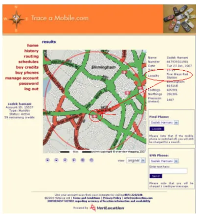
[image:5.596.56.280.277.356.2]For comparison purpose, we also used the location provided by Mobile Locate Ltd, which is one of the UK providers of mobile phone tracking services. As it can be seen the accuracy of such system is around few hundreds of meters, which is of few order of magnitude less accurate than the estimation provided by our system.
Figure 3. Position estimation and accuracy provided by the deve loped Kalman filter approach
Figure 4. Positioning using MobileLocate Ltd.’s service
B. Mobile Location services
The developed software referred as “GSM Mobile Locator” has been implemented in C# using Microsoft Visual Studio .NET 2003 is integrated in a PDA handset which is equipped with a GPS receiver, once the latitude/longitude coordinate of the MS is determined through the Kalman filter based methodology, the application communicates with Microsoft MapPoint server in order to enables location based services. The general methodology is shown in bloc diagram of Figure 5.
Legend : USER
BTS Selection
Distance Inputs
Route Selection
User actions
MapPoint Render Service
MS MapPoint Web Service
Positioning System
Mobile Location
Data
POI Locations Map
Display
USER
MapPoint Find Route Service Route
Itinerary
[image:5.596.340.507.471.694.2]MapPoint Find Nearby Service
Figure 5. Block diagram of Location based services
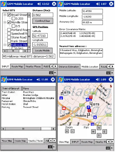
[image:5.596.45.288.510.694.2]Figure 6 shows some examples of results displayed in PDA.
Figure 6. Examples of PDA’s display while enabling location based services
The upper plot exhibits an instance of result using Hata-Okumura modal, outcomes of Kalman filter in terms of state estimation, i.e., latitude, longitude coordinate of the MS and the associated variance-covariance matrix. While the bottom left and bottom right display the points of interest as indicated by signs of restaurants, hospital, train station, parking, petrol station nearby the location of the MS.
V. CONCLUSION
In this paper, a new low cost methodology for mobile positioning using GSM standard and GPS location together with enhanced services has been put forward. The proposal uses NetMonitor software to retrieve received signal strength pertaining to the emitting base transmitter station as well as each of neighbouring base stations. A matching with government database of BTS allows us to identify the location and characteristic of each underlying BTS. A Hata-Okumura propagation model was used to determine the MS-BTS distance using the signal strength information. Next, an extended Kalman filter model was developed to combine the different distances together with the GPS readings in order to determine accurate positioning of the MS in terms of latitude and longitude coordinate. Finally, a connection to MapPoint server allows the user to access several enhanced services related to map construction, identification of nearby points and route tracer, etc. An experimental has been
carried out in Birmingham city centre and compared to typical commercial results of MobileLocation Ltd.
VI. REFERENCES:
[1] V.S. Abhayawardhana, I.J. Wassell, D. Crosby, M.P. Sellars, M.G. Brown, Comparison of Empirical Propagation Path Loss Models for Fixed Wireless Access Systems, in: Proceedings of the 61st IEEE
Vehicular Technology Conference, Stockholm, Sweden, 2005,
p.73-77.
[2] M. Ali, Survey of Current Location and Positioning Techniques, in:
Proceedings of the First European Workshop on Location Based
Services (LBS-2002), Sept., 2002,
[3] T. D’Roza T and G. Bilchev, An overview of location-based services. BT Technology Journal 21(1), 2003, 20-27
[4] C.C. Docket, Revision of the Commissions rules to ensure
compatibility with enhanced 911 emergency calling systems,
RM-8143, Rep. No. 94-102, FCC, 1994
[5] C. Drane, M. Macnaughtan and C. Scott, Positioning GSM Telephones, IEEE Communication Magazines, 36(4), 1998, 54-59
[6] ETSI TC-SMG, European digital telecommunications system (phase 2), Radio subsystem synchronization (GSM 05.10). ETSI-European Telecommunications, 1994, Version 4.4.0 [7] K Fujimoto, J. R. James, Mobile Antenna Systems Handbook,
Artech House, NY, 2nd Edition, 2001
[8] G.Gunnarsson, M. Allen, T. Rantalainen, V. Ruutu and V-M.Teittinen, Location Trial System for Mobile Phones, in:
Proceedings of the IEEE Global Telecommunication Conference.
The Bridge to Global Integration, 1998, 2211-2216.
[9] S. Hamani and M. Oussalah, Mobile Location System Using Netmonitor and MapPoint Server, Proceedings of 6th Anuual
PostGraduate Symposium on the Convergence of Telecommunications, Networking and Broadcasting, Liverpool John Moores University, June 2006, 17-23
[10] A. Kupper, Location-based Services: Fundamentals and
Applications, John Wiley and Sons, NY, 2005.
[11] M. Pent, M. A., Spirito and E. Turco, Methodfor positioning GSM mobile stations using absolute time delay measurements, Electronics Letters, Vol. 33 (24), 1997, 2019-2020
[12] G. L Stuber, Principles of Mobile Communication, Kluwer Academic Publishers, NY, 2002
[13] S.C. Swales, J.E. Maloney and J.O. Stevenson, Locating Mobile Phones and The US Wireless E-911 Mandate, in: Proceedings of IEE Colloquium on Novel Methods of Location and Tracking of
Cellular Mobiles and Their System Applications, 1999, p.2/1-2/6.
[14] D. Tse, P. Viswanath, Fundamentals of Wireless