Effective Information Delivery at
Construction Phase with Integrated
Application of RFID, GPS and GSM
Technology
J. Majrouhi Sardroud, M.C. Limbachiya
Abstract-- Construction projects generally take place
in uncontrolled and unprepared environments where accurate and timely information are vital to operating a well managed and cost efficient construction project. Automated advanced tracking and data storage technologies such as RFID and GPS give cost-effective, unobtrusive and hazard-free solutions for acquiring operations data in the relatively harsh and hectic environment of construction sites. This paper investigates the applications of integrated RF technologies such as RFID and GPS in the management and delivery of construction information. RFID integrated with the GPS provides an opportunity to collect data and to transfer them by GSM technology using minimal or no worker input.
Index Terms—Automation in construction,
Information management, RFID.
I. INTRODUCTION
Construction is recognized internationally as one of the information-intensive industry and subject to harsh conditions (e.g., rain and dust) and is often criticized for delivering projects late and over budget [1, 2]. Due to the complex, unprepared, information-intensive, and uncontrolled nature of the construction site, not only using of automated advanced tracking and data storage technologies for efficient information management is needed but also construction industry has greatly benefited from technology in rising the speed of information flow, enhancing the efficiency and effectiveness of information communication, and reducing the cost of information transfer[3]. Collection of detailed, accurate and a sufficient volume of information and timely delivery of them are vital to operating a well managed and cost efficient construction project[2].
J.MajrouhiSardroud is a PhD researcher at Kingston University London, school of civil engineering & construction, Kingston upon Thames, KT1 2EE, UK. (e-mail: [email protected])
M.C. Limbachiya is a full professor at Kingston University, and the head of school of civil engineering & construction, Kingston University London, Kingston upon Thames, KT1 2EE, UK. (e-mail: [email protected])
Information is a major resource utilized in construction projects. One of the major sources of information is the data collected on construction sites. Data collected accurately and comprehensively on a construction site and transferred timely to a site office is vital for correct assessment of job conditions that are used in managerial tasks (e.g., cost control). The current situations of on-site information management are paper-based information communication, non-automatic information management activities, and traditional information communication methods which do not provide real-time status information because of the amount of time required to pull all data from different reports together. Data collected using manual methods are not reliable or complete due to reluctance of workers to monitor and record the flow of large quantities of elements. Data collected through these methods are usually transferred and stored in paper-based format, which is difficult to search and access, and makes processing data into useful information expensive and unreliable. Thus, some information items end up being unavailable to the parties who need access to them in a timely manner to make effective decisions [4].
The process of capturing quantity of work data at a construction site needed to be improved in terms of accuracy and completeness to eliminate unnecessary communication loops and secondary tasks caused by missing or inaccurate data. Effective and immediate access to information minimizes the time and labor used for retrieving information related to each part of construction and reduces the occurrence of ineffective decisions that are made in the absence of information[5].
construction job sites and they are still gaps between site offices and actual work sites [6]. The emergence of ubiquitous system which is developed in this paper have the potential to enlarge the boundary of information systems from actual work sites to site offices and ensure real time data flow to and from the construction site.
This paper investigates the fully automated data collection using integrated applications of Radio Frequency Identification (RFID), Global Positioning System (GPS) and Global System for Mobile Communication (GSM) technologies in the construction industry which focused on the real-time exchange of information between the construction site and off-site office, how this technology could change current practice. Therefore the main objective of this study is to propose a system to improve efficiency and cost-effectiveness, practical communication and control among participants, and increase flexibility in terms of information delivery and response time on and off construction sites. Most of the used technologies in this research are commercially available and are inexpensive (RFID, GPS, GSM). The system concept can be divided into three tiers: clients (U-Box with integrated RFID and GPS technology), communication channel (GSM) and the server (database).
The remainder of this paper first reviews previous research and work that has been done by others relating to applications of RFID and GPS technologies in construction, followed by an assessment of the enabling technologies which are utilized in our research. Then it reveals the architecture of our integrated system for information delivery and management. Finally conclusion is given in the end.
II. RELATED WORK
Information is a major resource utilized in construction projects. Missing and delayed information access constitutes 50–80% of the problems in construction. One of the major sources of information is the data collected on construction sites. Data collected accurately and comprehensively on a construction site and transferred timely to a site office is vital for correct assessment of job conditions that are used in managerial tasks such as cost control [7].
Previous observations on construction sites cite that 30–50% of the field supervisory personnel’s time is spent on recording and analyzing field data [8] and 2% of the work on construction sites is devoted to manual tracking and recording of progress data [9]. Accuracy of the collected data
depends on judgments and writing skills of the people collecting data [10]. In addition, since most data items are not captured digitally, data transfer from a site to a field office requires additional time. When the required data is not captured accurately or completely, extra communication is needed between the site office and field personnel [11]. Advanced tracking and data storage technologies are integral to project management information systems in construction [12]. Radio Frequencies based information and communication technologies, such as GPS, RFID tags and Bluetooth etc, have matured and become commercially available to potentially support automated data collection in construction. Jaselskis and El-Misalami implemented RFID to receive and keep tracking of pipe spool in the industrial construction process. Their pilot test demonstrated that RFID could increase operation efficiency by saving time and cost in material receiving and tracking [13].
RFID, GPS and GSM enable collecting, storing and reusing field data accurately (i.e., without inaccurate recording of manual process), completely (i.e., without missing data), and timely (i.e., whenever needed). Some application of advanced tracking and data storage technologies in construction information management have been indicated previously [2, 5].
Although various studies exist for using new technologies in construction, studies focusing on detailed application of full automatic data collection and information management models are scarce. The application to an open environment like a construction site is still unproven.
technology for the construction industry that can be integrated into systems that can track materials, identify vehicles, and assist with cost controls.”[14]. RFID tags is more durable and suitable for a construction site environment because they are not damaged as easily, does not require line-of sight for reading and writing, can be read in direct sunlight, and survive harsh conditions, reusable and permit remote [15].
A. RFID OVERVIEW
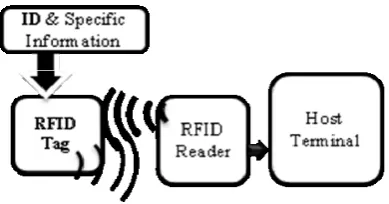
[image:3.595.72.267.453.555.2]RFID is a wireless sensor technology that is based on the detection of electromagnetic signals where radio frequencies are used to capture and transmit data from a tag or transponder. In other words, RFID is a method of remotely storing and retrieving data by utilizing radio frequency. An early, if not the first, work exploring RFID is the landmark paper by Harry Stockman, "Communication by Means of Reflected Power", Proceedings of the IRE, pp1196-1204, October 1948 [16]. Two decades ago RFID was introduced as the ultimate replacement for barcode. RFID tags is more durable and suitable for a construction site environment because they are not damaged as easily, does not require line-of sight for reading and writing, can be read in direct sunlight, and survive harsh conditions, reusable and permit remote. A RIFD system consists of tags (transponder), a reader (transceiver) and host terminal (middleware). A typical RFID system is shown in Figure 1.
Figure 1: A typical RFID system.
An RFID tag is an electronic label, such as an adhesive sticker, is a portable memory device on a chip that is encapsulated in a protective shell and can be embedded in any object and store dynamic information about the object. Tags which consist of a small integrated circuit chip coupled with an antenna to enable them to receive and respond to radio frequency queries from a reader. Tags can be categorized as read-only (RO), write once, read many (WORM) and read-write (RW) in which the volume capacity of their built-in memories varies from a few bits to thousands of bits. RFID tags can be classified into active tags (battery powered) and passive tags, which powered solely by the magnetic field emanated from the reader and hence have an
unlimited lifetime. Reading and writing ranges depend on the operation frequency (low, high, ultra high and microwave). Low frequency systems generally operate at 124 KHz, 125 KHz or 135 KHz. High frequency systems operates at 13.56 MHz and ultra high frequency (UHF) use a band anywhere from 400 MHz to 960 MHz [17]. Tags operating at ultra high frequency (UHF) typically have longer reading ranges than tags operating at other frequencies. Similarly, active tags have typically longer reading ranges than passive tags. Communication distance between RFID tags and readers may decrease significantly due to interferences by steel objects and moisture in the vicinity, which is commonplace to a construction site. Active tags have internal battery source and therefore have shorter lifetime of approximately three to ten years [13]. They can read, write and store significant amount of information, and be attached to sensors to store and communicate data to/from these devices. Some tags have an LED (light-emitting diode) that notifies the user with a blinking light when a tag and a reading device are communicating.
The reader, combined with an external antenna, reads/writes data from/to a tag via radio frequency and transfers data to a host computer. The reader can be configured either as a handheld or a fixed mount device. The host and software system is an all-encompassing term for the hardware and software component that is separate from the RFID hardware (that is, reader and tag); the system is composed of some components such as: Edge interface/system, Middleware, Enterprise back-end interface, Enterprise back end [18].
B. GPS OVERVIEW
GPS is a Global Positioning System based on satellite technology. The activities on GPS were initiated by the US Department of Defence (DOD) in the early 1970s under the term Navigation Satellite Timing and Ranging System (NAVSTAR). The first of a nominal constellation of 24 GPS satellites was launched in 1978, and the system was fully operational in the mid- 1990s. Galileo is a European Union Global Positioning System, Glonass is a Russian and BeiDou is the Chinese system [19, 20].
inclination angle of 55◦. GPS is a typical Medium Earth Orbit (MEO) system with an orbit altitude of approximately 20,200 km with regard to mean sea level. The control segment is responsible for monitoring and controlling the satellites subsystem health, status and signal integrity and maintains the orbital configuration of the satellites and consists of one Master Control Station and four unmanned monitor stations located strategically around the world. Finally, the user receiver equipment performs the navigation, timing, or other related functions (e.g., surveying) [21]. Each GPS satellite transmits signals at three distinct frequencies, namely: L1 (1575.42 MHz), L2 (1227.60 MHz) and L5 (1176.45 MHz). The L1, L2 and L5 carrier frequencies are generated by multiplying the fundamental frequency by 154, 120 and 115, respectively. The measured transmitting times of the signals that travel from the satellites to the receivers are used to compute the pseudo ranges. Two levels of navigation and positioning are offered by the GPS. They are the Coarse Acquisition Code (C/A-code), sometimes called the “Civilian Code,” and the Precise, or Protected Code (P-Code).The Course-Acquisition (C/A) code, sometimes called the Standard Positioning Service (SPS), is a pseudorandom noise code that is modulated onto the L1 carrier. The precision (P) code, sometimes called the Precise Positioning Service (PPS), is modulated onto the L1, L2 and L5 carriers allowing for the removal of the effects of the ionosphere. Each satellite carries its own unique code string. The SPS is a positioning and timing service focusing on the civilian user and the PPS is a positioning, velocity, and timing service for military applications [20]. Each receiver has a clock, enabling it to measure the travel time of signals from the satellites. Measuring the signals TOF from the satellites, whose positions are known, enables the calculation of the receiver’s 3-D position based on the trilateration principles. To calculate locations, the readings from at least four satellites are necessary, because there are four parameters to calculate: three location variables and the receiver’s time [22].
To get metric or sub metric accuracy in positioning data (i.e. longitude, latitude, and altitude), a single GPS receiver is not sufficient; instead a pair of receivers perform measurements with common satellites and operate in a differential mode. DGPS provides sufficient accuracy for most outdoor tracking applications. In DGPS two receivers are used. One receiver measures the coordinates of a stationary point, called the base, whose position is perfectly known in the reference geodetic system used by GPS. The 3-D deviation between the measured and actual position of the
base, which is roughly equal to the measurement error at a second receiver at an unknown point (called ‘‘rover’’), is used to correct the position computed by the latter [23]. The Real-Time Kinematic GPS (RTK GPS) can further enhance the positioning accuracy to centimetre (even millimetre) levels by combining the measurements of the signal carrier phases from both base and rover receivers with special algorithms.
C. GSM OVERVIEW
The idea of cell-based mobile radio systems appeared at Bell Laboratories in the early 1970s. In 1982 the Conference of European Posts and Telecommunications formed the Groupe Spécial Mobile (GSM) to develop a pan-European mobile cellular radio system (the acronym later became Global System for Mobile communications). In 1988, GSM system is validated.
The currently available technologies for mobile data transfer are Circuit Switched Data (CSD), High Speed Circuit Switched Data (HSCSD), General Packet Radio Systems (GPRS) and Third Generation (3G). Just as with audio transmission on landline phones, both CSD and HSCSD charges are based on the time spent using the dial-up connection. However, GPRS systems are sometimes referred to be as being always connected and dial-up modem connection is not necessary, so in comparison to CSD, immediacy is one of the advantages of GPRS (and SMS).
GPRS is a non-voice value added service that allows data to be sent and received across a mobile telephone network that was designed to run on GSM, a worldwide standard for cellular communications. Data transmissions in the past were slow across the radio interfaces due to many propagation and reception problems. To create a broadband communications interface, GPRS was developed as a stepping-stone approach to other services like the Enhanced Data for a Global Environment (EDGE). GPRS is a packet switched "always on" technology supporting Internet Protocols (IP) with a theoretical maximum speed of up to 114kbps. Because GPRS uses the same protocols as the Internet, the networks can be seen as subsets of the Internet, with the GPRS devices as hosts, potentially with their own IP addresses. In practice, connection speeds can be significantly lower than the theoretical maximum, depending upon the amount of traffic on the network and the type of handset being used [24].
status of construction information management, the potential opportunities of technologies are best deployed in the area of construction information management. The aim of this research is to identify opportunities for applying advanced tracking and data storage technologies in construction information management and to develop a model that explores how these technologies can be used in construction site environments to retrieve and transfer on-site information. After the reviews and evaluations of previous research and published literature, a conceptual model was developed from the perspective of information management.
[image:5.595.85.281.480.558.2]V. ARCHITECTURE OF THE UBIQUITOUS SYSTEM (U-BOX) The ubiquitous system utilized in this research is combination of GPS, RFID and GSM, and as such, takes advantage of the respective strengths of each. RFID integrated with the GPS and GSM technologies provides an opportunity to collect information and deliver them using minimal or no worker input. RFID technology will be used for identifying objects/users in a construction site. GPS technology will monitor the location of objects/users. The system mainly consists of three types of hardware components; namely, (i) RFID technology (RFID tags, readers, antenna); (ii) GPS technology (GPS receiver); and (iii) GSM technology. A schematic modelof U-Box is shown in Figure 2.
Figure 2: A schematic modelof U-Box
U-Box has a motion sensor which shows status of moving vehicle. Status will show vehicles are running or stopped. This feature will help U-Box to optimize the power consumption and also calibrate the stop positions. As you can see in the block diagram, the device has an internal battery which is rechargeable. Micro controller checks the source of power. If it’s still connected, micro controller sends a command to controller module to recharging the battery. Users can attach some external sensors to U-Box. Micro controller will get information of sensors and store them in internal memory and will send to data center via defined link. It has its own internal memory to store information (Lat, Long,
Alt, Speed, Data and Time, and etc.). Ability to save information when it lost GSM network, and sending saved information immediately after registering in the network.
In identification segment, due to longer reading range the UHF RFID has the potential to meet all of our needs in construction phase, and with an independent power supply active RFID tags allow greater communication ranges, higher carrier frequencies, greater data transmission rates, better noise immunity, and larger data storage capacity than passive RFID tags, and are typically read/write. In this segment for the cases where selective identification is not needed, objects/users can be identified automatically by tagging the objects/users and detecting them with a reader and for the cases where selective reading and automated identification are needed, a reasoning mechanism had to be developed and used to ensure that only information from the desired tag was recorded. In positioning segment the GPS unite will be durable to function in open air conditions. The GPS receiver used had a nominal accuracy of 5 m with WAAS (Wide Area Augmentation System). In data transmission segment we chose GPRS and Short Messaging Service (SMS) to support the data transmission between the ubiquitous system and the central office. GPRS connected to the GSM network via SIM card for data transfer enables several new applications which have not previously been available over GSM networks due to the limitations in message length of SMS (160 characters) such as Multimedia Messaging (MMS).
is to store only the unique object/user IDs directly on RFID tags and store all of the related information in one or more databases which will be indexed with the same unique IDs and the other extreme case is to store all the data in RFID tags locally and not to store any data in the server.
Off site tracking process begins when an order for the supply of materials or equipment is being placed. Suppliers attach RFID tags to all materials, components and possibly some bulk engineered items which are to be delivered in unit sets (e.g. pallets, packages, bags, etc.). The delivery vehicle is equipped with a U-Box system. Therefore, information during production (off-site), shipping (En-rout), and installation (on-site) could be collected by using U-Box.
The transmission of data (time, position (latitudinal and longitudinal coordinates), ID, and activity status of the users/objects) from the U-Box to the central database will be carried out with the help of standard cellular phone communications networks technology such as GSM. The selection criteria are a mix of the following: wireless link distance, coverage, data bandwidth and low power at wireless node.
Central database stores the status data collected during manufacturing, shipping, storage and installation. Therefore, data collection is done continuously, autonomously, and it is not influenced by the conditions on-site, such as line of site and weather, and information is transmitted back to the engineering office for analysis and documentation, enabling the generation of reports on productivity, cycle times, volume and material type, etc. which this up-to-date information about construction will enable effective management of project. In this research, a geo-referenced map of the construction job site should be created once, and then it will be used to identify locations of the objects/users by comparing the coordinates received from the GPS with those in the geo-referenced map. Citing factors such as screen size for RFID reader, outdoor readability, battery power, physical unit size and robustness are important considerations in the selection of appropriate hardware for the construction site. The use of appropriate software for the task of recording and accessing data is also an important factor. To minimize the performance reduction of selected technology under harsh conditions (e.g., rain or possible impacts from different pieces of equipment) and while in contact with metal and concrete, RFID tags need to be encapsulated or insulated.
VI. CONCLUSION
Proposed system is an application framework of RFID technology coupled with GPS and GSM technology for effective construction information delivery and management. The model permits real-time control enabling corrective actions to be taken. In this manner up-to-date information regarding all part of construction phase is available. It is believed that the application of this system will lead to important changes in the management and in the concept of operations of construction sites as well as in the processes of construction. The proposed system has numerous advantages. It is fully automatic, thus reducing the labour costs and eliminating human error associated with data collection during construction phase. In other word, the U-Box system is useful to improve the efficiency and effectiveness of automated data acquisition and information sharing between construction work site and construction site office. Proposed system needs assessments in varying conditions to test its performance in real-life environments. In practice, this system can deliver a complete return on investment within a short period by reducing operational costs and increasing workforce productivity. The authors believe that full automation of the Operation and data collection in construction industry can increase the efficiency and quality of the operation and lead to reductions in overall project costs and time.
REFERENCES
[1] S. Bowden, A. Dorr, T. Thorpe, and C. Anumba, "Mobile ICT support for construction process improvement," Automation in Construction, vol. 15,
pp. 664-676, 2006.
[2] A. H. Behzadan, Z. Aziz, C. J. Anumba, and V. R. Kamat, "Ubiquitous location tracking for context-specific information delivery on construction sites,"
Automation in Construction, vol. 17, pp. 737-748,
2008.
[3] L. C. Wang, Y. C. Lin, and P. H. Lin, "Dynamic mobile RFID-based supply chain control and management system in construction," Advanced Engineering Informatics, vol. 21, pp. 377-390, 2007.
[4] E. Ergen, B. Akinci, and R. Sacks, "Formalization and automation of effective tracking and locating of precast components in a storage yard," in 9th EuropIA International Conference(EIA-9), E-Activities and Intelligent Support in Design and the Built Environment, Istanbul, Turkey, 2003.
[5] B. Akinci, S. Kiziltas, E. Ergen, I. Z. Karaesmen, and F. Keceli, "Modeling and analyzing the impact of technology on data capture and transfer processes at construction sites: a case study," Journal of Construction Engineering and Management, vol.
132, pp. 1148-1157, 2006.
[6] J. Majrouhi Sardroud, M. C. Limbachiya, and A. A. Saremi, "An Overview of RFID Application in Construction Industry," in Third International RFID Conference Tehran, IRAN, 2009.
[8] B. McCullouch, "Automating field data collection on construction organizations," in 5th Construction Congress: Managing Engineered Construction in Expanding Global Markets, Minneapolis, 1997, pp.
957-963.
[9] G. S. Cheok, R. R. Lipman, C. Witzgall, J. Bernal, and W. C. Stone, "Non - Intrusive Scanning Technology for Construction Status Determination,"
Building and Fire Research Laboratory, National Institute of Standards and Technology, Gaithersburg, Md2000.
[10] L. Y. Liu, "Digital data-collection device for construction site documentation," in 2nd Congress on Computing in Civil Engineering, Atlanta, 1995, pp.
1287-1293.
[11] T. Thorpe and S. Mead, "Project-specific web sites: Friend or foe?," Journal of Construction Engineering and Management, vol. 127 (5), pp. 406-413, 2001.
[12] M. Lu, M. Anson, S. L. Tang, and Y. C. Ying, "HKCONSIM: A practical simulation solution to planning concrete plant operations in Hong Kong "
Journal of Construction Engineering and Management, vol. 129 (5), pp. 547-554, 2003.
[13] E. J. Jaselskis and T. El-Misalami, "Implementing radio frequency identification in the construction process," Journal of Construction Engineering and Management, vol. 129, pp. 680-688, 2003.
[14] E. J. Jaselskis, A. M. R., C. T. Jahren, Y. Rodriguez, and N. S., "Radio frequency identification applications in construction industry," Journal of Construction Engineering and Management, vol. 121, pp. 189-196, 1995.
[15] J. Majrouhi Sardroud, M. C. Limbachiya, and A. A. Saremi, "Ubiquitous Tracking and Locating of Construction Resource Using GIS and RFID," in 6th GIS Conference & Exhibition, GIS 88, 6 January,
Tehran, IRAN, 2010.
[16] J. Landt, "The history of RFID," IEEE Potentials,
vol. 24, pp. 8-11, 2005.
[17] ERABUILD, "Review of the current state of Radio Frequency Identification (RFID) Technology, its use and potential future use in Construction " 2006. [18] S. Lahiri, RFID Sourcebook: Prentice Hall, 2005.
[19] E. D. Kaplan and C. J. Hegarty, Understanding GPS, Principles and Applications, Second Edition ed. Norwood, MA 02062: ARTECH HOUSE, INC. USA, 2006.
[20] G. Xu, GPS · Theory, Algorithms and Applications,
Second Edition ed. Berlin: Springer, Germany, 2007. [21] A. Kupper, Location-based Services, Fundamentals
and Operation. West Sussex: John Wiley & Sons Ltd, England, 2005.
[22] G. T. French, Understanding The GPS - An Introduction to the Global Positioning System
Bethesda, MD 20814: GeoResearch, Inc. USA, 1996. [23] F. Peyret, D. Betaille, and G. Hintzy, "High-precision
application of GPS in the field of real-time equipment positioning," Automation in Construction, vol. 9, pp.
299-314, 2000.
[24] M. Ward, T. Thorpe, A. Price, and C. Wren, "Implementation and control of wireless data collection on construction sites," Electronic Journal of Information Technology in Construction, (ITcon),