1
ICT ENABLED PARTICIPATORY URBAN PLANNING AND
POLICY DEVELOPMENT: THE URBANAPI PROJECT
Zaheer Khan, University of the West of England, Bristol, United Kingdom,
David Ludlow, University of the West of England, Bristol, United Kingdom,
Wolfgang Loibl, Austrian Institute of Technology, Vienna, Austria,
[email protected]
Kamran Soomro, University of the West of England, Bristol, United Kingdom,
Abstact
Purpose – The aim of this paper is to present effectiveness of participatory ICT tools for urban planning and supporting bottom up decision making in urban management and governance.
Design/methodology/approach – This work begins with presenting state of the art literature on the existing participatory approaches and their contribution to urban planning and policy making process. Further, a case study – namely the urbanAPI project is selected to identify new visualization and simulation tools applied at different levels of urban scales. These tools are applied in four different European cities – Vienna, Bologna, Vitoria-Gasteiz and Ruse - with the objective to identify data needs for application development and commonalities in requirements of such participatory tools and their expected impact in policy and decision making processes.
Findings – The case study presents three planning applications i) 3D Virtual Reality at neighbourhood scale, ii) Public Motion Explorer at city wide scale, and iii) Urban Growth Simulation at city-region scale. These applications are dependent on specialized city data to develop required features and often data is not available in appropriate quality and necessitate data harmonization and pre-processing. In addition, urbanAPI applications indicate both active and passive participation secured by applying these tools at different level of urban scale and hence facilitate evidence based urban planning decisions. The level of urban scale at which these tools are applied plays a major role in acquiring participation from expert users or general public. In addition, regular engagement with the city administrations indicates commonalities in user needs and application requirements resulting in the development of generic features in these ICT tools which can be applied to other cities.
Research limitations/implications – Top down and bottom up urban planning and policy making needs vary from one city administration to another. This makes it difficult to capture and develop all required features in respective IT tools and often result in failure of software solutions. Therefore, the benefit of identifying commonalities among city needs and requirements for IT tools can result in development of common features and save huge investments in bespoke/ad hoc software development and maintenance costs. The urbanAPI application development follow a structured requirements development methodology where over 50% of commonalities are identified and as a result these tools can be applied at various stages of a policy making cycle/process. However, specialized data is required for the development of these applications which often does not exist in proper quality and format and hence necessitate data harmonization and pre-processing to ensure successful delivery of these tools.
Originality/value – This paper presents new ICT enabled participatory urban planning tools at different urban scale to support the collaborative decision making and urban policy development. Various technologies are used for the development of these IT tools and applied in the real environment of four European cities.
2
1
INTRODUCTION
Democracies have been challenged in recent times by increasing demands from citizens to take part in decision-making, for example infrastructure decisions and planning, especially at local and regional levels (Dahl R, 1998; Held D, 2006). The political systems of representative democracies have adapted to these challenges by becoming more responsive, opening up to the public in many ways and incorporating more participatory elements. As a result, citizens’ participation in urban planning and policy-making develops the traditional top-down governance model via promotion of bottom-up approaches to policy development and decision-making and often can be based a well-defined eDemocracy framework (Suree and Wichian 2009). This evolution drives social innovation in support of planning initiatives and results in more public-oriented policy specification for better governance and sustainable urban environment.
[image:2.595.105.515.307.635.2]In the above context, the development of ICT tools supporting urban management and governance focuses on information and intelligence needs within a well-defined policy making process (Khan Z et al, 2012), consisting of different procedural stages including: issue and problem identification, agenda setting including consideration of alternative development options, analysis, negotiation and decision making, implementation and finally evaluation as depicted in Figure 1 (Kraemar M, Ludlow D, Khan Z, 2013; Khan Z et al, 2012). In addition, ICT-enabled policy development and decision-making for urban management and governance require the involvement of various participants including citizens, stakeholders, practitioners and policy makers at different stages of the policy cycle.
Figure 1: Policy cycle – A Generic Policy Making Model (based on Michel K., et al 2013; Khan Z, et al. 2012)
3 (EXPGOV 2009). ICTs thereby are seen as enablers of more and better participation (e-Participation), and democracy (e-Democracy) and more inclusive societies (inclusive e-Governance and e-Inclusion), extending beyond enhanced service delivery, to facilitate interactions between actors. Overall technological opportunity is prompting a transformation of the relations between citizens and government agencies, and at the same time the driving forces of ICT enabled urban management are also responding to the dynamic of transformational governance and changes in regulatory, policy making and governance processes.
Critical in the above context is the recognition that investment in ICT enabled urban management, must be defined by a future vision of ICT enabled urban governance. Investments in a system of governance that is demonstrably failing, particularly in relation to the need for holistic and integrated urban management, will prove both costly and futile. Sound investment can only be made on the basis of user-defined concepts of governance, and associated requirements, that addresses the failings of the existing system and build on a future vision of transformational governance. Future visions of urban planning and ICT enabled urban governance build upon the analysis of commonality, and a model of a common fully interoperable information space (Hřebíček, J and Pillmann W, 2009). In this information space all agencies, at all levels of governance, and all stakeholders have equal access to information and intelligence necessary to secure the sustainable management of the city-region.
Despite all of the above, at the city level there is as yet only limited evidence of the direct effects of ICT-enabled innovations on city governance systems, and in many respects this revolution is still in infancy and clearly more research, particularly the pan-European level, is required to define the most effective tools and methodologies to support ICT enabled participatory urban governance.
In the above context, this research asserts the hypothesis: ‘ICT-enabled tools can help in transforming urban planning, decision making and policy making processes by adopting bottom up or a participatory governance model’. Consequently, it aims to answer the following research questions:
i) Do ICT tools help in transforming policy making and decision making processes? And,
ii) Can generic ICT tools be developed and applied in different cities for participatory urban planning, policy making and decision making?
In order to prove or disprove the hypothesis and respond to above questions, a case study based research methodology is adopted. This case study is based on an on-going project, namely, Interactive Analysis, Simulation and Visualisation Tools for Urban Agile Policy Implementation (UrbanAPI) project (UrbanAPI project, 2011-2014) 1 that aims to support top-down and bottom-up engagement in the decision making process through provision of selected software tools which collect, generate and combine necessary information at particular stages of the policy cycle to support decision making. The development of these tools is driven by stakeholder engagement and requirements gathering from four European cities i.e. Vienna, Vitoria-Gasteiz, Bologna and Ruse. Consequently, the enhanced ICT tools (virtual reality, visualisation and simulation) developed by UrbanAPI offer new opportunities for the development of both intelligence sources as well as tools for decision-making support at three levels of urban governance from neighbourhood to city-wide and city region level, thereby addressing the key dimensions of the management of urban complexity.
The conceptual frame for the project is based upon the understanding that urban managers throughout Europe face common challenges in responding to the desire for a more participatory democracy, in order to define the basis for urban economic vitality, social inclusion and environmental sustainability. The commonality of the drivers of urban change including global economic instability, demographic and migratory change, as well as climate change offers a major opportunity for the development of common solutions grounded in effective citizen and wider stakeholder engagement in the planning process.
UrbanAPI directly addresses these potentials for the development of common models of policy formulation and implementation in respect of both information generation and management, as well as stakeholder engagement, thereby supporting the potential for widespread application in the cities and regions of Europe.
1 The UrbanAPI project is funded under the European Commission’s Framework Programme Seven for the duration of three years
4 The structure of this paper as follows: in section 2, we present literature review followed by research methodology that is based on urbanAPI case study in section 3. In section 4, we briefly present research findings and their analysis, and discuss the overall research outcomes. Finally, we conclude in section 5.
2
THEORETICAL
BACKGROUND
AND
LITERATURE
REVIEW
Cities are transforming and seeking to harness the full benefits of ICT enabled “urban governance” (Montgomery et al, 2003; Ruble A Blair, et al. 2001; Eckhardt Felix and Elander Ingemar, 2011). These benefits are sought in order to manage the complexity of urban systems in responding to political objectives supporting sustainable urban development, ensuring an appropriate balance of socio-economic and environmental objectives defined in respect of land use management, and to fully engage with urban stakeholder communities in this process (Davies R. Sarah et al 2012; Poplin Alenka, 2011; Hanzl Malgorzata, 2007;Misuraca G et al 2011).
For instance, forms of engagement with stakeholders by the state have evolved from an emphasis on top-down hierarchical models towards networked models, from steering and directing society to contextual steering and incentive provision (Rhodes 1997, Pierre & Peters, 2000). An important driving force in this transformation concerns the information overload arising from the complexity of urban systems management, experienced in both political and technical management. This has reinforced the understanding that traditional planning methodologies are outdated, and has highlighted an increasing need for tools to support the involvement of the public in decision-making, and to assist in citizen assessment of the impacts of policy-making, creating enhanced intelligence, and applied to both the management of urban complexity as well as enhancement of e-democracy (Felt & Wynne, 2007).
In the above context, the following related dimensions/aspects are covered in the literature review: i) public participation, ii) urban planning, and iii) ICT and urban governance, which collectively support policy development and decision making processes.
2.1
Public Participation
Wampler Brian and McNulty Stephanie (2011) define participatory governance as, ‘…consists of state-sanctioned institutional processes that allow citizens to exercise voice and vote, which then results in the implementation of public policies that produce some sort of changes in citizens’ lives…’. Other researchers argue that public participation should be seen as multi-way interaction in which citizens and other stakeholders are involved formally and informally to influence actions in the public arena before it is considered as final conclusion to develop and implement specific policies (Innes and Booher 2004). In addition, Rowe & Fewer (2005) clearly define key concepts in the domains: public communication, public consultation and public participation, to mitigate misconceptions about public participation. They also provide a comprehensive typology of communication, consultation and engagement mechanisms. Previously Rowe & Fewer (2000) reviewed different public participation methods and proposed an evaluation framework based on acceptance and process criteria.
Among others, Suree and Wichian (2009) introduced a framework for the development of tools for sustainable eDomocracy which consists of five main components: Stakeholder and policy; Methodology; ICT; Environment; and, e-Democracy system which provide useful ingredients for the development of an eDemocracy system. They also defined a quality model to develop this eDemocracy framework. Apparently, this framework provides useful insights for the development of applications like eInformation, eService, eVoting, eComplaint, eForum etc. Such a framework can also be applied for the development of participatory tools for urban planning and management.
2.2
Urban Planning
5 resources (e.g. Open data initiatives) now planners have more flexibility to perform planning activities and involve different stakeholders, including citizens (Poplin Alenka, 2011; Hanzl Malgorzata, 2007), in informed decision making processes. These issues suggest developing structured mechanisms and processes to effectively use ICT for urban governance and management of cities, as proposed by Khan et al (2012). In this regard, the urbanAPI tools and applications help in collecting integrated intelligence for better decision making in transformational urban planning.
2.3
ICT and Urban Governanace
ICT tools and applications have developed rapidly and in a variety of different ways including direct democratic experiments such as planning cells, public assessment exercises and moderated discussions of various kinds, to experiments with the science/policy interface and impact assessment (Liberatore & Funtowicz 2003; Boyd & Chan, 2002). Citizens have incorporated a number of roles in these experiments including active and participative, critical in the oversight of politics and administration, productive in generating data useful for assessing public services, and efficient in co-producing public services. Whilst this is clearly a demanding set of roles, there is evidence that participatory decision-making in the framework of urban governance initiatives has the potential to widen and deepen democratic decision-making and public service delivery (Wampler Brian and McNulty Stephanie, 2011). According to some researchers, concepts attributed to “transformational governance” (Jacquier C 2005; Jacquier C 2008; Weerakkody V et. al, 2008; Weerakkody V et. al, 2011; Janssen M & Zuiderwiik A, 2012) have also emerged in response to the specific demands for the delivery of holistic urban planning to secure sustainable urban development in which partnership is key. Transformational governance emphasises the essential need for traditional top-down expert-driven and sectorally defined urban planning to be combined with bottom-up processes of stakeholder engagement and partnership formation (Albrechts Louis, 2010).
With the rapid ICT innovations e.g. Web 2.0/3.0, crowd sourcing, 3D Interactive visualisation and simulation for past and future urban growth, access to smart phones and web, availability of ambient environmental sensors and Internet of Things and computing and storage capacities using cloud computing, enable multi-way interaction for participatory governance. Many ICT related planning and analysis tools have been developed helping citizens to understand decisions and impacts by providing quantitative and visual outputs for development scenarios, providing access to decision polls or helping to explore citizens behaviour to improve urban design and infrastructure (Boyd & Chan, 2002). Similarly, many ICT applications have been developed for participatory urban planning e.g. mobile phone 3D Augmented Reality application for Vienna (Lang & Sittler, 2012), Turku SoftGIS for Helsinki (Kahila & Kyttä, 2010; Kyttä, 2011), Public motion explorer using GSM mobile data for Vienna (Loibl & Peters-Anders, 2012), etc. However, most of existing tools and applications are limited in terms of providing rich and extensive interactive operations (i.e. editing, deleting or modifying scenarios) which can further support public participation in defining future urban models and contribute towards policy development.
Recognizing the potential of ICT tools, local and national governments have started to share public data for transparency and control, civic participation, development of new innovative product and governmental efficiency (Parycek Peter, Sachs Michael, 2010; Open Government Data, 2012). However, researchers (Marijn Janssen and Anneke Zuiderwijk, 2012) argue that open data initiatives from local and national governments share public data but require further investigation in adopting this data in planning, policy making and public participation by introducing new mechanisms and transforming current processes. They also indicated that major focus is on publishing the data and there are no mechanisms and/or processes for public engagement to capture intellectual inputs for planning, policy making and decision making. This suggests that city administrations should identify new mechanisms or reengineer current processes, as suggested by other researchers (Weerakkody V, et al 2011), in order to utilise open data and promote public participation for greater benefits. The urbanAPI tools and applications utilise data from city databases as well as open data from various national and European data sources to better present urban models and secure public engagement.
6 bottom-up processes of social networking and crowd sourcing facilitate engagement with urban planning structures and decision-making processes. Indeed social networking and crowd sourcing offers new means of communication and engagement between the multiple and various stakeholders that support the bottom-up processes of sustainable urban governance (Silva C., 2010; Jaquier C, 2005).
2.4
UrbanAPI tools and applications
The urbanAPI project deals with the above challenges through city region scenarios developed at different urban scales and provide further insights in harmonising and integrating data from various agencies and departments in order to promote bottom up and participatory planning, policy development and decision making. In this section we present review of literature that is more specific to urbanAPI application: 3D Virtual Reality (3D VR), Public Motion Explorer (PME) and Urban Growth Simulation (UGS).
Using virtual reality applications for urban planning is not a new concept. For example, initial attempts were made in late 1990s to show the benefits of interactive 3D applications to urban planning and public participation and since then many aspects have been investigated (Doyle et al. 1998; Al Kodmany 2002; Manoharan et al. 2002; Stellingwerffet al., 2004; Zhang et al. 2007). However, a general issue is always to create interactive 3D worlds (and other IT policy support tools) with data collection, feedback and adopted steering mechanisms effectively, i.e. with verifiable impact (Hayek et al., 2010) and efficiently, i.e. with low effort (Hanzl, 2007). Costs were often cited to be high, while the re-usability and maintainability, e.g. with live data, was not emphasised (Latoschik et al. 2007). The urbanAPI 3D VR applicationis built on the basis of the CityServer3D2 integration service which has already been proven in use by various city administrations, with up to 50 data sources and hundreds of GB of data volume. Upcoming standards such as X3D-Earth (Daly et al., 2008) permit delivery of portrayed 3D geodata to a various clients, ranging from HTML5/WebGL Web Browsers over CAVEs and MultiTouchTables to Smart Phones (Reitz et al., 2009). In X3D, interactivity can be defined, and links to arbitrary image or XML data can be included. In this way, live or pre-recorded data from sensors can be integrated or orthoimagery and maps can be loaded from view services. The urbanAPI 3D VR application uses the open source X3DOM WebGL binding3 developed by Fraunhofer IGD to exploit the next generation of Web Browsers as clients. In addition to above, urbanAPI provide generic toolset e.g. Rule Editor and domain specific rule language as current rule-based systems try to solve a wide range of problems, but do not take into account specific issues that arise in the area of GIS. Therefore urbanAPI Rule Editor is developed with a new front-end to be used for defining rules in a special language adapted to the problem domain with specific policy modelling examples presented in (Kraemer et al 2013).
Research dealing with communication device location patterns started recently (Ahas et al., 2005; Gartner et al., 2007). Current approaches (Jinxing et al, 2009; Michalopoulou et al, 2010) present tests, initial applications and first results. Several projects have been undertaken by university researchers to locate the population, to examine fluctuations in geographic population distribution, to assess the mobility patterns or via mobile phone distribution in Graz, Amsterdam, Rome and Milano (Ratti et al., 2006), Shenzen, China (Jinxing et al., 2009), and others. All these projects make use of anonymized data provided by the GSM mobile service providers. UrbanAPI PME application takes a step further based on the following novel investigations:
1. Sojourn/activity distribution, described as volume of mobile devices connected with one cell.
2. Communication density, by counting the number of active mobile devices per GSM cell.
3. Population mobility, depicted through tracking of connection handovers or devices between base stations
For strict privacy reasons, urbanAPI PME application is mainly concentrating on the first issue for mapping sojourn/activity distribution and sojourn/activity dynamics to explore the usage (and attractiveness experience) of open space and other pedestrian environments.
In literature, Cellular Automata concepts are applied to model urban growth and urban planning i.e. only land use (Batty 2007; Li et al., 2003; Benenson et al., 2004). However, the foundations of UGS application are based
2 URL: http://www.cityserver3d.de/en/
7 on Agent-based models (ABMs) for land use change simulation model individual behaviour of actors (residents, developers, entrepreneurs and stakeholders) as agents and decision makers resulting in collective effects on changes in land use pattern (Loibl et al., 2007; Loibl et al 2010). In urbanAPI, spatial planning interventions are introduced by allowing end users to interact with application via visual screen. Consequently, model recalculation is performed using GPU processing to accelerate the simulation and map visulisation and provide a 3D simulation model.
3
RESEARH
METHODOLOGY
[image:7.595.98.536.372.533.2]In an attempt to answer the above research questions, authors adopt combination of case study, supported by an extensive literature review, and applied research methods as depicted in Figure 2. A comprehensive literature review provided basis for development of new participatory ICT tools (section 2 above). As a result, the case study is based on an EC FP7 UrbanAPI-project - a collaborative research project, in which eleven partners from six European countries are collaborating to develop ICT tools to support policy making, urban planning and participatory governance at different urban scales. UrbanAPI aims to develop three generic ICT applications: i) 3D Virtual Reality (3DVR), ii) Public Motion Explorer (PME), and iii) Urban Growth Simulation (UGS), to support urban management by collaborative decision-making and public engagement in the planning process. Furthermore, in order to deliver attributes essential for urban planning decision-making tools in compliance with local city needs, particularly in relation to ensuring effective engagement with stakeholders including citizens (Davies S et al 2012; Poplin A, 2011; Hanzl M, 2007), urban planners from the project case study cities including Vienna (Austria), Bologna (Italy), Vitoria-Gasteiz (Spain) and Ruse (Bulgaria), are actively engaged in project related research, especially to define city policy related needs and system requirements and assessment of overall impact of these tools.
Figure 2: Overall Research Methodology
3.1
Background and Context of UrbanAPI Project
Evidence from recent surveys of European city engagement in ICT enabled urban management and governance, and a broader spectrum of smart city related initiatives demonstrates that with, notable exceptions of innovatory progress, currently there is only limited evidence of the positive impacts of ICT-enabled innovations on urban management and city governance systems (Relhan, et al., 2011). It is reasonable to argue that the ICT driven revolution remains in its infancy, and that progression towards a more mature status, and wider acceptance by European cities, can only benefit from further research to identify a more comprehensive vision of its effective application, particularly where a clear user defined requirement is established. It is precisely this sort of ambition that is addressed by the UrbanAPI project (2011-2014) as presented in this paper.
UrbanAPI aims to develop ICT enabled tools supporting city governance and adapted governance models particularly addressing stakeholder engagement and citizen participation in the planning process, in order to enhance sustainable urban policy development and delivery. These tools aim to provide planners and policy makers with the information they need to expose the socio-economic and environmental impacts associated with
UrbanAPI
Project
Participatory urban planning Urban management
Policy making
Application 1: 3D Virtual Reality
Application 2: Public Motion Explorer Application 3: Urban Growth Simulation
City
Administrations
Literature
Survey
Vienna (Austria) Bologna (Italy) Vitoria-Gasteiz (Spain) Ruse (Bulgaria) ICT tools for above apps
State of the art
Case Study
Real
Practical
Applications
provides
8 alternative options for territorial development, and at the same time create conditions in which the political mandate as a critical basis for more effective management, is secured (Yigitcanlar et al, 2008). The main stakeholders addressed in the UrbanAPI project relate to three different interest groups: i) planning authorities interested in software solutions and application in their cities, ii) policy makers interested in content communication and means to intervene in the urban development process, and iii) ‘ordinary citizens’, laypersons with respect to methodology, but experts in local issue identification and specification of alternative development solutions.
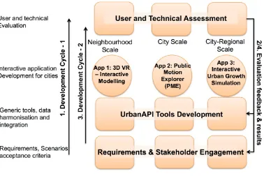
[image:8.595.93.471.297.549.2]UrbanAPI adopts the agile system development methodology like SCRUM (Deemer P. et al 2012). This means multiple application development activities run concurrently and are repeated in multiple cycles (i.e. two cycles for UrbanAPI) to obtain improved results. Figure 3 shows that the overall process is initiated with ‘Requirements gathering and stakeholder engagement followed by generic tools development which can be utilised for the development of 3DVR, PME and UGS applications for participating cities. The assessment of these applications results in the identification of the limitations of these applications and/or gathering new evolving requirements and, subsequently the entire development process is repeated. One of the major benefits of this agile methodology is regular stakeholder engagement at different stages of the toolset and application development process that helps in specifying and validating necessary and common requirements specification, resulting in generic but nonetheless user defined ICT tools.
Figure 3: UrbanAPI development methodology
The ambition of the project research is not restricted to that concerning the project cities alone, however, as it is evident that the drivers of change influencing the development of European cities have common global and pan-European origin (Kingston, 2007, Relhan et al, 2011). Accordingly, lessons generated from the comparative assessment of the applications developed in the differing project case study city contexts, can form the basis for the future development of generic ICT tools that can be utilised in the majority of the 446 cities4 of Europe with populations over 100,000, as well as other smaller cities and towns throughout Europe.
3.2
UrbanAPI Application Matrix – City Scenarios
The fundamental driving force behind the development of urbanAPI ICT toolset was state of the art literature
9 and need for ICT innovations in participatory urban plannig, policy making and decision making. However, these findnigs are further strengthened by developing additional user specific requirements by the public administrations of case study cities. Most of the cities are participating in up to two different applications that aim to explore the potentials of the applications in relation to context specific socio-economic, environmental and territorial characteristics, governance structures and practices, and furthermore to define potential commonalities as a basis for the development of generic ICT applications. Table 1 identifies the city participation in the different UrbanAPI applications, defined according to local policy priorities.
Table 1: UrbanAPI City Applications
3D VR Public Motion
Explorer
Urban Growth Simulation
Vienna √ √
Bologna √ √
Vitoria-Gasteiz √ √
Ruse √
4
EMPIRICAL
FINDINGS,
ANALYSIS
AND
DISCUSSION
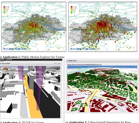
The UrbanAPI toolset aims to provide advanced ICT-based intelligence in relation to three urban planning contexts and spatial scales. First, UrbanAPI directly addresses the issue of stakeholder engagement and citizen participation in the planning process by the development of enhanced 3D virtual reality (3DVR) visualisation of neighbourhood development proposals. This 3DVR application also enables end users to access and propose amendments to planning proposals using interactive visual interface via the web. Second, at the city-wide scale, UrbanAPI is developing a public motion explorer (PME) application, a mobile phone location based application using mobile phone location data (also referred as GSM data), that permits the visual representation, and analysis of population distribution and movement patterns across the city which assists planning agencies to explore space attractiveness and carry out mobility analysis. Finally, UrbanAPI is developing urban growth simulation (UGS) for city-regions, addressing multiple urban planning challenges including visualisation of planning interventions and assessment of the impact of alternative proposals for urban expansion (and/or shrinkage) in the peri-urban area, and the optimum distribution of residential, employment and associated services.5 Basic snapshots of the visual interfaces of these three UrbanAPI applications are depicted in Figure 4.
Collectively three UrbanAPI applications aim to provide vital decision-making aids for urban planners in the management of the territory, as well as for associated requirements in political negotiation, and wider stakeholder engagement regarding the future development of the urban region. In doing so UrbanAPI also aims to support the development of transformational governance, the shift from a purely top-down planning approach to one which is fully engaged with bottom-up initiatives supported by public intervention.
10
a) Application 1: Public Motion Explorer for Vienna
[image:10.595.88.545.68.471.2]b) Application 2: 3D VR for Vienna c) Application 3: Urban Growth Simulation for Ruse
Figure 4: UrbanAPI applications: a) Application 1: PME application – Population distribution dynamics in the Vienna Region during the morning hours (left: 10:30-10:45; right: 11:45-12:00) of a sample day 2009 (Source: Loibl & Peters-Andres, 2012), b) Application 2: 3DVR application Vienna – adding annotations, c) Application 3: UGS application – 3D View of Ruse.
Major findings of the urbanAPI can be classified into following three main categories: i) data specific, ii) process specific, and iii) urbanAPI tools and application specific. The first two are more related to issues identified while developing urbanAPI tools and applications whereas the third is related to participatory aspects and attractiveness of specific applications for different cities.
4.1
Data specific
Data plays a crucial role in the development of urbanAPI applications. Three main issues require special considerations to deal with application specific data which can be useful for the development of similar ICT tools and applications. These issues are:
i) Application specific data requirements: Identifying the data requirements early based on application requirements specification helps in identifying which particular features can be implemented. This also helps in identifying alternate sources of data which can be utilised.
11 3D data for 3DVR application requires to build new 3D models using 2D city data. Similarly, historical socio-economic and urban development data (e.g. taxation, lot prices, etc) at city-region scale for the development of UGS appliaction is either limited or not availabe in required format (e.g. language, resolution, district unit et).
iii) Cost of application specific data: Not all the data is freely available and can be accessed on certain payment. For example, GSM data for PME application is acquired from mobile data provider companies which often charge for such data.
4.2
Process specific
Structured processes need to be applied at various development stages of the urbanAPI tools and applications due to the complexity of the urbanAPI applications and involvement of various stakeholders. These processes are:
i) Requirements development process: Due to applied nature of the urbanAPI project a rigorous requirements development process is applied that consists of the following activities: i) background and context, ii) requirements workshop, iii) scenario development and requirements specification, iv) requirements validation, and v) requirements management. This process and detailed requirements are documented in (Khan Z and Ludlow D 2013).
ii) Data collection process: A structured data collection process ensures that necessary data elements have been collected, analysed and transformed for application development. In urbanAPI project a hybrid data collection process is applied on the basis of identified data requirements using top-down approach i.e. using existing application prototypes, and bottom-up approach i.e. using cities application feature requirements.
iii) Software development process: Agile software development process can be useful to secure regular stakeholder engagement for feedback on developing application features.
iv) Evaluation process: A comprehensive user and technical evaluation using Criteria, Indicators and Metrics methodology (Khan Z, et al 2013) is applied to secure usability, functionality, benefits, relevance and impact of urbanAPI applications. The overall evaluation process is documented in detail and accessible from (Khan Z 2012).
v)
Stakeholder engagement process: The iterative nature of software development process necessitates to engage with urbanAPI stakeholders mainly city administrations and external bodies e.g. stakeholder board i.e. organisations who are not directly invovled in the development of the project but have vested interest in the outcomes and are willing to oversee overall project progress and provide technical input. Regular meetings and online feedback mechanism are utilised to secure feedback from stakeholders.4.3
UrbanAPI tools and Application specific
Each urbanAPI application is designed to capture specific aspects related to planning and policy development and hence provide certain characteristics which may be attractive to one city administration then other. Use of specialised software tools as well as skills are applied in the development of these applications. Below we present strengths and weaknesses found regarding three urbanAPI applications. These are:
12 large amounts of rich 3D models imported in different formats including CAD, GIS databases, selected elevation views and textured information.
ii) PME application: This application helps urban planners to acquire information regarding the population distribution and mobility patterns for various land uses. This information helps planning agencies to manage public and private transportation within the cities according to policy objectives. For example, number of movement patterns between specific districts during specific times of days/nights to generate origin-destination matrices. PME application also helps to observe the populations preferences for certain open spaces – parks, nearby forests or recreation areas and public open spaces including pedestrian areas and playgrounds. However, the real challenge in PME application is acquiring GSM data from mobile service providers and the quality and required information within GSM data is often not suitable to analyse and generate useful and complete results. For example, smaller cities like Vitoria-Gasteiz where geographical size of the city is too small to be appropriate for 500m grid cells to represent population distribution at certain time of day/night.
The overall concept of using GSM data to represent tempospatial population distribution and mobility can be utilised for multiple applications including: environment analysis e.g. effect of air pollution or noise on general public;
capacity planning of public traffic infrastructure;
identifying attracted areas and evidence based planning for future investments for
improvements in those areas, etc.
iii) UGS application: This application is applied to both city and city-region scales and helps in understanding the large scale consequences of complex spatial planning decisions including socio-economic activity in relation to land-use elements of the city. In addition, interactive control of proposed planning interventions and associated impacts generated by these interventions assists the public interactively engaging in the planning processes and contributing to planning decisions. Detailed and easy understandable information about planning decisions and full transparency about the expected impacts will support the negotiation activities during a participatory planning process and will finally increase public commitment to these decisions. The agent based model for simulating land use-‐‑ and land use density change in a 3D and high-resolution cellular landscape (e.g. 100x100 m grid) permits the allocation of new infrastructure by hand to observe the urban development effects, triggered through planning interventions in Ruse territory. Like PME application, UGS is also highly dependant on the availability of historical data to train agents and predict future behaviour accordingly. UGS allows identifying urban development effects through historical dynamic land use maps and data and learning about interaction between various variables. It also explores land-use effects and effects of population growth; alternative planning guidelines; planning interventions e.g. major roads, bridges etc. UGS also allows to carry out planning interventions to perform interactive exploration of planning policies and decisions i.e. what if analysis, and simulating the overall effects.
4.4
Analysis and discussion
This section critically analyse and discuss the above findings in response to the reseach questions and hypothesis set aside in section 1. These findings are reflected in view of the tools presented in urbanAPI case study from following two aspects:
i) UrbanAPI tools and applications supporting various stages of policy development process: Figure 1 depicts a generic policy process as a cycle representing different stages of the policy-making process (boxes). The process begins with the ‘Issue Identification’ stage (a.k.a survey) that collects domain specific data e.g. socio-economic and environmental relevant to the issue of urban development, etc. either by using surveys, polls, or ICT technologies e.g. sensor nets, etc. for problem or issue identification. This stage can be seen from top-down policy making perspective e.g. such issues can be either identified from policy makers or planning agencies by initiating a new project in 3D VR application or from a bottom up perspective e.g. by acquiring passive public participation in PME or UGS application.
13 all three urbanAPI applications support this stage by presenting alternative scenarios including proposals and suggestions by participants.
The ‘Development and analysis stage’ utilises data gathered at the ‘Issue identification’ stage and based on the priorities set up in ‘Agenda setting stage’, and provides an assessment of the territorial impacts, in respect of socio-economic and environmental variables, that identify the problem to be resolved by the plan. In the ‘Negotiation/decision-making stage’ urban planners provide a proposition for future development of the urban territory typically subject to public and wider stakeholder consultation, following which a political commitment is made by elected officials of the municipality to the implementation of the plan. Implementation of the plan (in the Implementation stage) over the plan period of several years involves commitments by a variety of public agencies acting in concert to secure the objectives of the plan in order to respond to the problems identified at the survey/analysis stages and to provide a framework for private investment in the development of the urban area. Again all three urbanAPI applications enable passive and active participation on planning proposals. This also leads to identify public preferences and new issues which can be taken further in future policy cycles.
The Evaluation stage is focused around the monitoring of the implementation of the plan to identify the extent to which the plan is achieving the objectives identified with the policies of the plan, and where it is failing to fully meet the policy objectives of the plan, to provide a basis for reformulation of the plan in the next stage of the policy cycle. The process repeats in a cycle in order to assess and improve current policy implementation.
The above analysis helps in answering the research question: ‘Do ICT tools help in transforming policy making and decision making processes?’. And, based on the urbanAPI project results we can conclude that ICT tools help in transforming policy making and decision making processes to a certain extent by engaging with various stakeholders including public at some stages of the policy development cycle to acquire feedback and influnce on the policy and decision making. This suggests that additional tools can be developed or integrated to fill the gap at other stages of the policy making process e.g. social networking, crowd sourcing at ‘Issues Identification’ stage. In addition, an integrated workflow based approach is needed to better utilise outcomes of every previous policy development stage at the very next stage as proposed in (Kraemar et al 2013). This would result in semi-automated data collection and analysis for policy and decision making.
ii) Identifying the commonalities in ICT tools requirements based on stakeholder engagement and cities scenarios: The starting point for this analysis of commonalities is the understanding that global socio-economic and environmental forces, the drivers of change, have common impacts on European cities, indeed on cities throughout the world (Lambin Eric F. et al 2001; ESPON, 2010; United Nations, 2010). These common drivers of change and their impacts assist in defining political priorities at the local level. These political priorities include mitigation and adaptation responses to climate change, controlling urban sprawl supported by compact city solutions, as well as delivering commitments for urban growth and social cohesion. These common political priorities invite common solutions in urban management delivered by common processes of governance, that invite the development of generic ICT applications and methodologies.
Based on the urbanAPI case study and development of detailed requirements specifications for ICT application mostly derived from cities needs helped in analysing and identifying common requirements to develop generic software features which can be applied in various other cities. In addition, these commonalities help in avoiding the reinvention of the wheel (i.e. developing something which has already been implemented) in an R&D collaborative project where resources are limited.
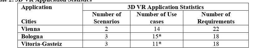
[image:13.595.98.506.645.722.2]In UrbanAPI the following tables (Tables 2 and 3) represent the total number of scenarios, use cases and requirements defined for the 3DVR and public motion explorer applications for each case study city.
Table 2: 3D VR Application Statistics Application
Cities
3D VR Application Statistics Number of
Scenarios
Number of Use cases
Number of Requirements
Vienna 2 14 22
Bologna 3 15* 18
Vitoria-Gasteiz 3 11* 18
14 Preliminary analysis derived from the UrbanAPI CoReS method application (Khan Z and Ludlow D 2013) indicates that nearly 50% commonality exists between two or more city requirements for the 3DVR application. These common requirements include usability aspects such as need for visual aid; data synchronisation and integrity; public participation and ease of interaction with the application; accessibility of the application using different platforms e.g. web, smart phones; change impact assessment; importing new data and exporting results in common formats; and conformance to city administration IT policies.
[image:14.595.90.499.215.294.2]On the one hand this suggests, based on the commonalities in city requirements, that generic tools and services can be developed which can be exploited in fulfilling the specific needs of a wide range of city administrations in Europe. On the other hand individually specified requirements from cities can also indicate new potentials which can be developed to enhance functional features and improve the overall functionality of the 3DVR application.
Table 3: Public Motion Explorer Application Statistics Application
Cities
Public Motion Explorer Applications Statistics Number of
Scenarios
Number of Use cases
Number of Requirements
Vienna 3 8 22
Bologna 2 7 13
Vitoria-Gasteiz 3 20* 18
* there are common use cases between different scenarios of the city application
In a similar fashion to the 3DVR application, there exist about 60% commonalities between two or more city requirements for the public motion explorer (PME) application. These requirements include usability aspects such as need for intuitive user interface; visualisation of aggregated population; indication of places attractive to the public; extrapolation of results to the overall city population; identification of social biasing; visualisation of motion traces between city districts/zones; intra-city and extra-city origin-destination matrices and travelling mode; accessibility using different platforms; importing new mobile phone data and exporting results in common formats; integration of PME data with data from other sources e.g. GPS, survey information, city administration IT standards compliance; and workflow documentation.
Based on the above findings we can respond to research question: ‘Can generic ICT tools be developed and applied in different cities for participatory urban planning, policy making and decision making?’. The above analysis for 3DVR and PME applications strengthens the claim in the research question that generic tools can be developed to facilitate development of participatory ICT applications and their wider adoptability where more specific requirements from cities add value to these common capabilities.
Answers to the above questions help in proving the hypothesis: ‘ICT-enabled tools can help in transforming urban planning, decision making and policy making processes by adopting bottom up or a participatory governance model’ and we can conclude that specialised ICT tools and applications help in participatory urban planning, decision making and policy making processes and adopting bottom up governance model to a certain extent. Development of more integrated tools applied at all policy development stages can be useful in collecting participatory data and performing analysis to take evidence based decision making and promoting bottom up policy making.
5
CONCLUSIONS
AND
FUTURE
RESEARCH
15 In addition to above, the urbanAPI case study reveals that a significant percentage of common application requirements generated by case study cities can provide the basis for the development of generic functionalities in the ICT tools. For example, a preliminary analysis of the UrbanAPI requirements specification of four different European cities indicates that there are over 50% commonalities in policy development and decision making processes, and hence demand for generic capabilities in the interactive ICT enabled participatory applications at different governance scales can be useful and applicable to other European cities.
However, many requirements for the development of the urban management system vary between cities, which may be attributed to the local specifics including policy needs and priorities. Furthermore, the quality of data also varies from one city to another, placing constraints on the development of common solutions for different cities and so challenging the IT community to adopt software design patterns which permit the implementation and integration of these more specific features with the generic software systems. Based on the experiences of urbanAPI project, our future research direction aims to develop design patterns to enable use of existing ICT tools and develop new applications. Furthermore, we aim to investigate and integrate aspects of social networking as crowd sourcing for participatory planning and policy making.
References
Suree Funilkul, Wichian Chutimaskul, (2009) ‘The framework for sustainable eDemocracy development’, Transforming Government: People, Process and Policy, Vol. 3 Iss: 1, pp.16 – 31
Ahas R. and Ülar M. (2005) Location based services—new challenges for planning and public administration? Futures, 37:6 547-561 doi:10.1016/j.futures.2004.10.012.
Al-Kodmany, K. (2002) Visualization Tools and Methods in Community Planning: From Freehand Sketches to Virtual Reality. Journal of Planning Literature, 17(2), 189 -211. doi:10.1177/088541202762475946.
Batty, M. (2007) Cities and Complexity: Understanding Cities with Cellular Automata, Agent-Based Models, and Fractals. The MIT Press, Cambridge, MA
Benenson, I. and Torrens, P.M. (2004) Geosimulation: Automata-Based Modelling of Urban Phenomena, John Wiley & Sons, London, UK.
Daly, L. & Brutzman, D. (2008) X3D: extensible 3D graphics standard. In ACM SIGGRAPH ASIA 2008 courses, SIGGRAPH Asia ʹ08 (S. 22:1–22:6). New York, NY, USA: ACM. doi:10.1145/1508044.1508066.
Doyle, S., Dodge, M., & Smith, A. (1998) The potential of Web-based mapping and virtual reality technologies for modeling urban environments. Computers, Environment and Urban Systems, 22(2), 137-155.
doi:10.1016/S0198-9715(98)00014-3.
Gartner, G., Cartwright, W., & Peterson, M.P. (Eds) (2007) Location Based Services and TeleCartography. Berlin, Heidelberg: Springer Berlin Heidelberg. http://www.springerlink.com/content/g5m5q15r046571mj/.
Hanzl M. (2007) Information technology as a tool for public participation in urban planning: a review of experiments and potentials in: Design Studies 28 (2007) 289-307.doi:10.1016/j.destud.2007.02.003.
Hayek, U.W. & Get-Regamey, A. (2010) Virtuelle Landschaften zur partizipativen Planung der
16 Jinxing, H., Wenjing, C., Luo, J. and Xiaomin, Y. (2009) Dynamic modeling of urban population travel behavior based on data fusion of mobile phone positioning data and FCD. In Geoinformatics 2009 (1-5). Lecture given at International Conference on GeoInformatics 2009, Fairfax, VA.
Latoschik, M.E. & Fröhlich, C. (2007) Towards intelligent VR - _multi-layered semantic reflection for intelligent virtual environments. In GRAPP (AS/IE) (S. 249-260).
Liu, Y., & Phinn, S.R. (2003) Modelling urban development with cellular automata incorporating fuzzy-set approaches. Computers, Environment and Urban Systems, 27(6), 637-658. doi:10.1016/S0198-9715(02)00069-8 .
Loibl, W., Tötzer T, Köstl M., Steinnocher K. (2007) Simulation of polycentric urban growth dynamics through agents - _Model concept, application, results and validation. In: Koomen, E., Stillwell, J., Bakema, A. and Scholten, H., (Eds.), Modelling Land-Use Change – Progress and applications, Springer, Dortrecht, 219-235.
Loibl, W. and Walz, A. (2010), Generic Regional Development Strategies from Local Stakeholdersʹ _Scenarios -
_an Alpine Village Experience; in: Ecology and Society 15(3): 3.
Manoharan, T., Taylor, H., & Gardiner, P. (2002) A collaborative analysis tool for visualisation and interaction with spatial data. In Proceedings of the seventh international conference on 3D Web technology, Web3D ʹ02 (S. 75–83). New York, NY, USA: ACM. doi:10.1145/504502.504515.
Michalopoulou M, Riihijärvi J and Mähönen P (2010) Studying the Relationships between Spatial Structures of Wireless Networks and Population Densities. RWTH Aachen University, Institute for Networked Systems.
Ratti,C., Pulselli, R.M., Williams, S. & Frenchman, D. (2006) Mobile Landscapes: using location data from cell phones for urban analysis, URL: http://www.envplan.com/abstract.cgi?id=b32047.
Reitz, T., Krämer, M., & Thum, S. (2009) A processing pipeline for X3D earth-based spatial data view services. In Proceedings of the 14th International Conference on 3D Web Technology, Web3D ʹ09 (S. 137–145). New York, NY, USA: ACM doi:10.1145/1559764.1559786.
Stellingwerff, M., & Kuhk, A. (2004) 3D/4D Communication tools for facilitators in public participation. In Architecture in the Network Society. Proceedings of the 22nd Conference on Education and Research in Computer Aided Architectural Design, pp 593-600.