MORPHOMETRIC AANALYSIS OF RUPIN DRAINAGE BASIN IN WESTERN
HIMALAYA: USING GEO
*Sunil Kumar, Chauniyal
Department of Geography, H.N.B. Garhwal University, Srinagar, Uttarakhand
ARTICLE INFO ABSTRACT
Morphometric
understand to the nature of the different landforms and structure in given area. Morphometric analysis of a watershed provides a quantitative description of the drainage s
of the characterization of watersheds (Strahler, 1964). Morphometric analysis includes three parameters
particular area like
characteristics. In this paper, the study area is a part of the greater Himalaya and resulted landform topography and terrain feature of the three natural processes like as glac
Rupin drainage basin and its tributaries created such as various type landform and landscape development and hydraulic action of the study area. In the present morphometric analysis of the Rupin Basin has been carried out wit
the result and impact of tectonic to the morphometry of Rupin drainage basin.
Copyright © 2016, Sunil Kumar et al. This is an open access article distributed under the Creative distribution, and reproduction in any medium, provided the original work is properly cited.
INTRODUCTION
Morphometric analysis is a basic geomorphic study of an area. Morphometry is defined as the measurement and mathematical analysis of the configuration of the earth’s surface and of the shape and dimension of its landforms (Clarke, 1966). The importance of the morphometry describes various geomorphic processes and landforms development of the earth surface. Morphometry includes of linear, areal and relief aspects of the fluvial based drainage basin. Natural and human behavior impacts on river basin like as landslides, e
agricultural, settlement, industry, transportation system etc. have change the directly and indirectly drainage system of the particular area. Morphometric analysis find out basic characters on the geometrical and mathematical aspects of the river basin which is help to understand the tectonic characteristics and evolution of the landscapes in the river basin. The morphometric parameter have been analysed for the first time proposed by Horton (1945). The study of the various morphometric parameters like as stream order, stream length, mean stream length, stream length ratio and bifurcation ratio are linear aspects. The areal aspect describes like as stream frequency, drainage density, drainage texture, form factor,
*Corresponding author: Sunil Kumar,
Department of Geography, H.N.B. Garhwal University, Srinagar, Uttarakhand
ISSN: 0975-833X
Article History: Received 15th July, 2016
Received in revised form 20th August, 2016
Accepted 08th September, 2016
Published online 30th October,2016
Key words:
Morphometric analysis, Remote Sensing & GIS, Rupin basin.
Citation: Sunil Kumar, Chauniyal, D. D. and Surajit Dutta, techniques”, International Journal of Current Research
RESEARCH ARTICLE
MORPHOMETRIC AANALYSIS OF RUPIN DRAINAGE BASIN IN WESTERN
HIMALAYA: USING GEO-SPATIAL TECHNIQUES
Sunil Kumar, Chauniyal, D. D. and Surajit Dutta
Department of Geography, H.N.B. Garhwal University, Srinagar, Uttarakhand
ABSTRACT
Morphometric analysis is a measurement and quantitative description of any drainage basin. It is understand to the nature of the different landforms and structure in given area. Morphometric analysis of a watershed provides a quantitative description of the drainage s
of the characterization of watersheds (Strahler, 1964). Morphometric analysis includes three parameters-linear, areal and relief aspects of a drainage basin through the general description about the particular area like as physiological feature, geological structure and development of the landform characteristics. In this paper, the study area is a part of the greater Himalaya and resulted landform topography and terrain feature of the three natural processes like as glac
Rupin drainage basin and its tributaries created such as various type landform and landscape development and hydraulic action of the study area. In the present morphometric analysis of the Rupin Basin has been carried out with the help of the remote sensing and GIS techniques. It has also given to the result and impact of tectonic to the morphometry of Rupin drainage basin.
is an open access article distributed under the Creative Commons Attribution License, which distribution, and reproduction in any medium, provided the original work is properly cited.
analysis is a basic geomorphic study of an area. Morphometry is defined as the measurement and mathematical analysis of the configuration of the earth’s surface and of the shape and dimension of its landforms (Clarke, 1966). The try describes various geomorphic processes and landforms development of the earth surface. Morphometry includes of linear, areal and relief aspects of the fluvial based drainage basin. Natural and human behavior impacts on river basin like as landslides, earthquakes, agricultural, settlement, industry, transportation system etc. have change the directly and indirectly drainage system of the particular area. Morphometric analysis find out basic characters on the geometrical and mathematical aspects of the ver basin which is help to understand the tectonic characteristics and evolution of the landscapes in the river basin. The morphometric parameter have been analysed for the first time proposed by Horton (1945). The study of the various ers like as stream order, stream length, mean stream length, stream length ratio and bifurcation ratio are linear aspects. The areal aspect describes like as stream frequency, drainage density, drainage texture, form factor,
Department of Geography, H.N.B. Garhwal University, Srinagar,
circularity index, elongation ratio and length of the overland flow. The relief measurement like as relative relief, absolute relief, basin length etc. are the relief aspe
Study Area
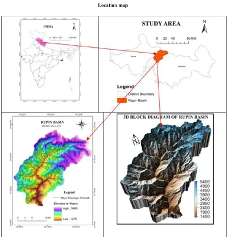
The present study area is Rupin River which is a source head tributary of Tons river (a tributary of Yamuna River)
the boundary of Himachal Pradesh and Uttarakhand. The study area falls partly under the Lesser and Higher Himalay region. It is geographically located between 77°58 77°18′36′′ E longitude and 31°03′57′′ to 31°21′35′′ N latitude covering an area of 536 km2. Out of which
Shimla District of Himachal Pradesh and 33% in Uttarkashi District of Uttarakhand. Rupin River rises from the cirque floor of Rupin Ghat at the height of
glacial Taals at the source of the source head from which numbers of streams rises. After passing 43.63 km. distance it joins in Supin River at Naitwar village (1294 m)
Ultimately Supin River and Rupin River joins at Naitwar village after known as Tons River from this place. The main left bank tributary of the Rupin River is Nargani River which rises from the peak of 5526 m height and
Jiskun Village. Dodu Gad and Gulgar Khad are the two parental streams of the Nargani Gad which rises from the glacial terrain and joins each other at the height of 3074 m.The name of Nargani Gad starts from the confluence of Doda Gad
Available online at http://www.journalcra.com
International Journal of Current Research
Vol. 8, Issue, 10, pp.40110-40117, October, 2016
INTERNATIONAL
Sunil Kumar, Chauniyal, D. D. and Surajit Dutta, 2016. “Morphometric aanalysis of rupin drainage basin in western himalaya: Using geo
International Journal of Current Research, 8, (10), 40110-40117.
z
MORPHOMETRIC AANALYSIS OF RUPIN DRAINAGE BASIN IN WESTERN
Department of Geography, H.N.B. Garhwal University, Srinagar, Uttarakhand
analysis is a measurement and quantitative description of any drainage basin. It is understand to the nature of the different landforms and structure in given area. Morphometric analysis of a watershed provides a quantitative description of the drainage system, which is an important aspect of the characterization of watersheds (Strahler, 1964). Morphometric analysis includes three linear, areal and relief aspects of a drainage basin through the general description about the as physiological feature, geological structure and development of the landform characteristics. In this paper, the study area is a part of the greater Himalaya and resulted landform topography and terrain feature of the three natural processes like as glacial, peri-glacial and fluvial. Rupin drainage basin and its tributaries created such as various type landform and landscape development and hydraulic action of the study area. In the present morphometric analysis of the Rupin h the help of the remote sensing and GIS techniques. It has also given to the result and impact of tectonic to the morphometry of Rupin drainage basin.
ribution License, which permits unrestricted use,
circularity index, elongation ratio and length of the overland flow. The relief measurement like as relative relief, absolute relief, basin length etc. are the relief aspects.
The present study area is Rupin River which is a source head tributary of Tons river (a tributary of Yamuna River) between the boundary of Himachal Pradesh and Uttarakhand. The study area falls partly under the Lesser and Higher Himalaya region. It is geographically located between 77°58′08′′ to ′36′′ E longitude and 31°03′57′′ to 31°21′35′′ N latitude . Out of which 77% area falls in Shimla District of Himachal Pradesh and 33% in Uttarkashi Uttarakhand. Rupin River rises from the cirque floor of Rupin Ghat at the height of 4854 m. There are numbers of glacial Taals at the source of the source head from which numbers of streams rises. After passing 43.63 km. distance it at Naitwar village (1294 m) (Fig. 1). Ultimately Supin River and Rupin River joins at Naitwar village after known as Tons River from this place. The main left bank tributary of the Rupin River is Nargani River which rises from the peak of 5526 m height and joins in Rupin near Jiskun Village. Dodu Gad and Gulgar Khad are the two parental streams of the Nargani Gad which rises from the glacial terrain and joins each other at the height of 3074 m.The name of Nargani Gad starts from the confluence of Doda Gad
INTERNATIONAL JOURNAL OF CURRENT RESEARCH
and Gulagar Khad. The other major left and right bank tributaries of the Rupin River are North Rupin Gad, Middle Rupin Gad, West Rupin Gad, Tela Khad and East Rupin Gad.
Geology
Tectonically the Rupin basin is falls under between the MCT north and Naitwar group of rocks in the south. The main tectonic unit of the study area is Jutogh Thrust, Chail Thrust
and Mautar Thrust. The main rock types of different
formations are carbonaceous schists, mica schist, quartzite and schist. Intercalation of carbonaceous layers and thick schist bands are quite common. These rocks are highly jonted and fractured in the basin.
Objectives
1. To analyze relief characteristics of Rupin Basin. 2. To understand the morphometric characteristics of
Rupin Basin.
MATERIALS AND METHODS
The achievements of the objectives Remote Sensing and GIS Techniques are applied for the morphometric analysis. The base map has been prepared on the basis of Survey of India Topographical Map 1:50,000 scale. All streams are digitized and stream order calculated following by Strahler method (1964) with the help of Arc GIS Software 9.3. Slope and topographical elevation map were prepared by ASTER DEM 30 m spatial resolution, Landsat Image (ETM+) with 30 meter spatial resolution is also used for the landforms analysis of the study area. The entire basin area is divided into 1 sq. km. grids and each morphometric parameter calculated in each grid and the landforms was verified through the field survey.
RESULTS AND DISCUSSION
[image:2.595.77.525.55.520.2]In the present study, the morphometric analysis are different parameters, namely relative relief, absolute relief, stream order, stream length, bifurcation ratio, stream frequency, Location map
drainage density, drainage texture, form factor, elongation ratio, etc. The morphometric analysis is given following table and description.
Relief Aspect
Relief aspects referred to three dimensional features of the basin which includes area, volume and altitude of the landforms. In this study, relief aspect involves the analysis of slope aspect, average slope, absolute relief, relative reliefs etc. Relief aspects are the most important factor to understand the denudation processes of the river basin and it’s indicates the flow direction of the water. Relief aspects are resulted various landform of the basin.
Hypsometric Analysis
Hypsometric curve is relation between relative area and relative height of the basin. The shape of the hypsometric curve described to assess the evolutionary status of watersheds. Strahler (1952) compared and evaluated different shapes of hypsometric curves pertaining to different drainage basins, and classified the basins according to their stages of geomorphological evolution as: youth stage (convex upward curves, where HI ≥ 0.60), mature stage (S-shaped hypsometric curve which is concave upward at high elevations and convex downwards at low elevations, where 0.30 ≤ HI ≤ 0.60), and old stage (concave upward curve, where HI ≤ 0.30). The hypsometric integral value of rupin basin is 0.49 which indicates the mature stage of the basin.
Absolute Relief
Absolute relief is the measurement of actual height of a particular area above sea level. The categorized of Rupin basin is eight physiographic Zones e.g. (<2000 metre), (2000- 2500 metre), (2500 – 3000 metre), (3000 -3500 metre), (3500 – 4000 metre), (4000 – 4500 metre), (4500 – 5000 metre) and (>5000 metre) covering an area of 5.28%, 12.84%, 19.23%, 23.36%, 15.97%, 15.45%, 7.54, and 0.32% respectively of the total basin area. It is describe that the area is covering 0.32% glacier area and high altitude and highest covering area between 3000 – 3500 altitudes (Fig. 7).
Relative Relief
Relative relief is the different between the high altitude and low altitude in a per unit area. This is used for the analysis of the geomorphological characteristics of landforms and direction of the landform faces. The relative relief of the Rupin basin is categorized into five types, e.g. Very Low (<200 metre), Low (200 – 400), Moderate (400 - 600 metre), High (600 – 800) and Very High (>800 metre) covering an area of 0.47%, 26.33%, 51.18%, 21.31 and 0.71% respectively which describes into 1km by 1km grids and shows that the basin is moderately dissected and landform development early mature stage condition (Fig. 8).
Slope Analysis
Slope is the representation of degree of horizontal landform. The slope is describes the landform inclination between top of hill and bottom of the earth surface and generally express in degree or percent. Strahler (1964)15 expressed, "the inclination
or gradients of the surface of a basin in terms of maximum valley side slope, measured at interval along the valley walls in the steepest part of the contour orthogonal running from divides to adjacent steam channels". The slope of Rupin basin is divided into six categories. e.g. Nearly level slope (0 – 10 degree), Very gentle slope (10 – 20 degree), Gentle slope (20 - 30 degree), Moderate slope (30 – 40 degree), Steep slope (40 - 50 degree) and Very steep slope (>50 degree) covering an area of 4.27%, 15.48%, 27.46%, 28.57%, 17.08% and 7.14% respectively which describes into 1km by 1km grids and describe the basin is moderately dissected and large area is moderate slope covered (Fig. 9).
Slope Aspect
Slope aspects map is describe that the slope facet direction of the sun angle. Rupin river is flow from north to south direction between two water divided ranges extending from east to west. So the describes east and west aspect of the study area. The Rupin basin is divided into eight slope aspects. A slope aspect indicates that which area effect is denudational process. The settlement location depends on slope aspect condition. The slope aspect of the Rupin basin is covered entire direction of the area and the settlement is situated northern and southern aspect of basin. The vegetation and forest growth depends on slope aspects condition. The dense forest of the study area is located eastern and southern aspect area and northern area is open forest and shrub type vegetation of basin (Fig. 10).
Dissection Index
Dissection Index is a parameter referring to the degree of dissection or vertical erosion, and the stage of landforms development in any given watershed (Singh, S. and Dubey, A. (1994). Dissection index is the measurement of the vertical erosion landforms. Dissection index is the ratio relative relief and absolute relief of the basin which indicates 0 is absence of dissection and 1 is extreme dissection of the landforms. In this region, the dissection index is 0.77 which indicates the Rupin basin is highly dissected landform and youth stage of geomorphic development (Table 2).
Ruggedness Number
Ruggedness number is product of basin relief and drainage density. Extreme high values of ruggedness number occurs when both variables are large, this is when slope are not steep but long as well (Strahler, 1964). The ruggedness number is 0 shows smooth landform and 1 or over 1 shows that high badland topography.The ruggedness number of Rupin basin is 13.80 which indicates steep slope, interrupted by uneven topography landform and high erosion mass movement. In this area peak discharge is very high and rejuvenation stage (Table 2).
Shape Index
Shape index is the ratio of square of basin length and area of the basin (Horton, 1945)18. It is denotes shape irregularity of the basin. It is impact on the rate of the water and deposition of sediment in basin. The shape index value of Rupin river basin is 2.13 which indicate moderate erosion of the basin and less effect of the area (Tabel 2).
Fitness Ratio
According to Melton (1957), the ratio of main channel length to the length of the watershed perimeter is fitness ratio, which is describe of the landform characteristics of the basin. The fitness ratio of the Rupin basin is 0.38 which indicate nearly circular shape and moderate impact of the basin landforms and structure (Tabel 2).
Linear Aspect
Linear aspects is the measurements of linear features of drainage such as stream order, bifurcation ratio, stream le stream length ratio, length of overland flow etc. The Rupin river basin is discussed the linear characteristics below.
Stream Order
The first step in geomorphological analysis of a drainage basin is the designation of stream order, stream ordering as suggested by Horton (1945)4 and slightly modified by Strahler (1964). According to Strahler (1964)5, “Higher order is associated with grater discharge and the trunk stream
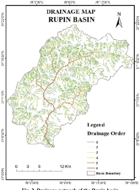
[image:4.595.306.563.153.306.2]which all discharge of water and sediment passes is therefore the stream segment of highest order.” It is found that Rupin river tributaries are of 6th order and identified length of different order stream (Table no. 1). Generally, the drainage patterns of the Rupin basin are dendtrict and structural control topography (Fig. 2).
Fig. 2. Drainage network of the Rupin basin
Stream Number
The count of stream channels in each order is known as stream number. R.E. Horton is credited with formulating a law of According to Melton (1957), the ratio of main channel length to the length of the watershed perimeter is fitness ratio, which is describe of the landform characteristics of the basin. The upin basin is 0.38 which indicate nearly circular shape and moderate impact of the basin landforms and
Linear aspects is the measurements of linear features of drainage such as stream order, bifurcation ratio, stream length, stream length ratio, length of overland flow etc. The Rupin river basin is discussed the linear characteristics below.
analysis of a drainage basin is the designation of stream order, stream ordering as and slightly modified by Strahler , “Higher order is associated with grater discharge and the trunk stream through which all discharge of water and sediment passes is therefore the stream segment of highest order.” It is found that Rupin order and identified length of different order stream (Table no. 1). Generally, the drainage tterns of the Rupin basin are dendtrict and structural control
Drainage network of the Rupin basin
The count of stream channels in each order is known as stream number. R.E. Horton is credited with formulating a law of
[image:4.595.40.284.402.733.2]stream number, which describe that the number of streams of different orders in a given drainage basin tends to closely approximate an inverse geometric ratio. This inverse geometric relationship is shown graphically in the form of a straight line (Fig. 3). Most drainage networks show a linear relationship with small deviation from a straight line. This means that the number of streams usually decreases in geometric progression as the stream order increases.
Fig. 3. Relation versus stream order and stream number of the Rupin basin
Bifurcation Ratio
The bifurcation ratio is the ratio between the number of streams of given order to the
higher order. Horton (1945) and Schumm (1956) considered the bifurcation ratio as an index of relief and dissection. The bifurcation ratio charecterestically ranges between 3.0 to 5.0 for basin in which geological structure d
drainage pattern (Strahler, 1964). The bifurcation ratio of Rupin Basin ranges from 3.88 to 5.20 which show that the whole basin area is Rupin lie in the mature stage.
Mean Bifurcation Ratio
The mean bifurcation ratio may be defined as
bifurcation ratios of all order. The mean bifurcation ratio of the Rupin Basin is 3.88, which indicates the geological structures are strong structural control over the drainage development and pattern (Table 1).
Fig. 4. Relation versus stream order and stream length of the Rupin basin
Stream Length
The stream length has been calculated based on law of stream by Horton (1932). Stream length is the most significant stream number, which describe that the number of streams of different orders in a given drainage basin tends to closely nverse geometric ratio. This inverse geometric relationship is shown graphically in the form of a straight line (Fig. 3). Most drainage networks show a linear relationship with small deviation from a straight line. This means that the ally decreases in geometric progression
Relation versus stream order and stream number of the Rupin basin
The bifurcation ratio is the ratio between the number of number of streams in the next higher order. Horton (1945) and Schumm (1956) considered the bifurcation ratio as an index of relief and dissection. The bifurcation ratio charecterestically ranges between 3.0 to 5.0 for basin in which geological structure do not distort the drainage pattern (Strahler, 1964). The bifurcation ratio of Rupin Basin ranges from 3.88 to 5.20 which show that the whole basin area is Rupin lie in the mature stage.
The mean bifurcation ratio may be defined as the average of bifurcation ratios of all order. The mean bifurcation ratio of the Rupin Basin is 3.88, which indicates the geological structures are strong structural control over the drainage development and
Relation versus stream order and stream length of the Rupin basin
[image:4.595.310.559.570.720.2]hydrological Characteristics of the basin. It expresses the surface runoff characteristics and nature. The smaller stream length is relatively larger slope and finger drainage texture of the basin while, Longer Stream length indicates flatter gradient of the basin. Generally, the total length of stream segments is a maximum in first order stream and decreases as stream order increases (Fig. 4). The numbers of stream are founded various orders in a watershed and their lengths (Table 1). The stream length may be change from various factors like as altitude, lithological variation and slope.
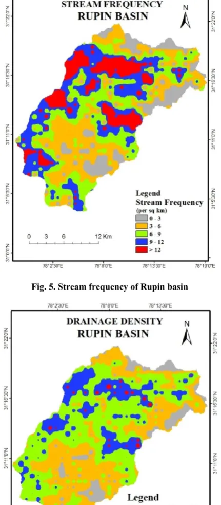
Fig. 5. Stream frequency of Rupin basin
[image:5.595.55.271.196.688.2]Fig. 6. Drainage density of the Rupin basin
Fig. 7. Hypsometric Curve of Rupin Basin
Mean Stream Length
The mean stream length describes the nature of drainage network and its association of the surface basin. The mean stream length is a dimensionless property, characterizing the size aspects of drainage network and its linked surface (Strahler 1957). It is calculated by dividing the total length of stream order and total number of stream segments in the order. The mean stream length varies from 0.57 to 29.50 of Rupin river basin. The mean stream length of Rupin basin is 0.57 for the first order, 0.63 for the second order, 1.28 for third order, 2.48 for fourth order, 7.25 for the fifth order and 29.50 for the sixth order (Table 1).
Stream Length Ratio
The stream length ratio can be defined as the ratio of the mean stream length of a given order to the mean stream length of next lower order and has an important relationship with surface flow and discharge (Horton, 1945). The values of stream length ratio show variation in slope and topographic development of the study area. The stream length varies from 1.10 to 4.07 and its express change in length ratio one order to another order. It is indicate that youth stage to early mature stage of the basin (Table 1).
Length of Overland Flow
It is most important variable of the hydraulic and physiographic development of drainage basin and impact of channel slope and flow discharge. Length of overland flow is defined as half of the inverse of drainage density and the distance from the crest line at which the concentration of flow occurs (Horton, 1945). Length of overland flow value is 0.15 for this basin to describe the smaller path for the concentration of flow. It shows the small path of stream flow and high peak of the basin (Table 1).
Areal Aspects
Areal aspect is the most important quantitative parameter of geomorphological study. Areal aspects includes like as stream frequency, drainage density, form factor etc. The areal aspect has been resulted given below.
[image:5.595.57.270.452.773.2]
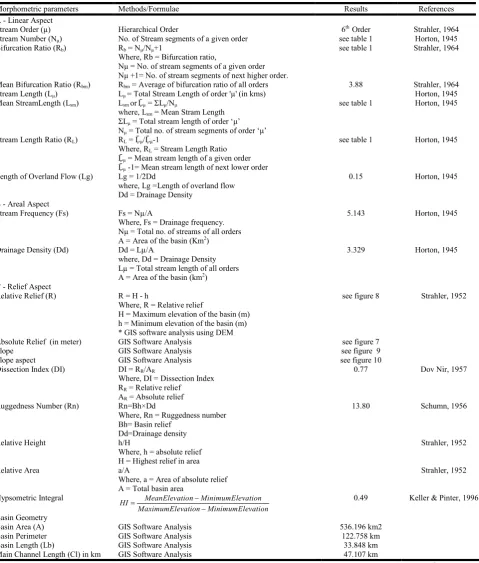
Table 1. Results of Morphometric Analysis
Strean Order (µ)
No. of Streams (Nµ)
Bifurcation Ratio (Rb)
Mean Bifurcation Ratio (Rbm)
Stream Length (Lµ) km
Mean Stream Length (Ḹµ) (km)
Stream Length Ratio (RL)
Length of Overland Flow (Lg)
1 2131 4.33 1212.18 0.57 0.00
2 492 4.87 307.62 0.63 1.10
3 101 3.88 128.78 1.28 2.04
4 26 5.20 3.88 64.48 2.48 1.94 0.15
5 5 5.00 36.26 7.25 2.92
6 1 0.00 29.50 29.50 4.07
Total 2756 23.29 1778.81 41.70 12.08
Table 2. Morphometric Parameters of Rupin Basin
Morphometric parameters Methods/Formulae Results References
A - Linear Aspect
Stream Order (µ) Hierarchical Order 6th Order Strahler, 1964
Stream Number (Nµ) No. of Stream segments of a given order see table 1 Horton, 1945
Bifurcation Ratio (Rb) Rb = Nµ/Nµ+1
Where, Rb = Bifurcation ratio,
Nμ = No. of stream segments of a given order Nμ +1= No. of stream segments of next higher order.
see table 1 Strahler, 1964
Mean Bifurcation Ratio (Rbm) Rbm = Average of bifurcation ratio of all orders 3.88 Strahler, 1964
Stream Length (Lµ) Lµ = Total Stream Length of order 'µ' (in kms) Horton, 1945
Mean StreamLength (Lsm) Lsm orḸµ = ΣLμ/Nμ
where, Lsm = Mean Stram Length
ΣLμ = Total stream length of order ‘μ’
Nμ = Total no. of stream segments of order ‘μ’
see table 1 Horton, 1945
Stream Length Ratio (RL) RL = Ḹµ/Ḹµ-1
Where, RL = Stream Length Ratio
Ḹµ = Mean stream length of a given order
Ḹµ -1= Mean stream length of next lower order
see table 1 Horton, 1945
Length of Overland Flow (Lg) Lg = 1/2Dd
where, Lg =Length of overland flow Dd = Drainage Density
0.15 Horton, 1945
B - Areal Aspect
Stream Frequency (Fs) Fs = Nµ/A
Where, Fs = Drainage frequency. Nμ = Total no. of streams of all orders A = Area of the basin (Km2)
5.143 Horton, 1945
Drainage Density (Dd) Dd = Lµ/A
where, Dd = Drainage Density Lµ = Total stream length of all orders A = Area of the basin (km2)
3.329 Horton, 1945
C - Relief Aspect
Relative Relief (R) R = H - h
Where, R = Relative relief
H = Maximum elevation of the basin (m) h = Minimum elevation of the basin (m) * GIS software analysis using DEM
see figure 8 Strahler, 1952
Absolute Relief (in meter) GIS Software Analysis see figure 7
Slope GIS Software Analysis see figure 9
Slope aspect GIS Software Analysis see figure 10
Dissection Index (DI) DI = RR/AR
Where, DI = Dissection Index RR = Relative relief
AR = Absolute relief
0.77 Dov Nir, 1957
Ruggedness Number (Rn) Rn=Bh×Dd
Where, Rn = Ruggedness number Bh= Basin relief
Dd=Drainage density
13.80 Schumn, 1956
Relative Height h/H
Where, h = absolute relief H = Highest relief in area
Strahler, 1952
Relative Area a/A
Where, a = Area of absolute relief A = Total basin area
Strahler, 1952
Hypsometric Integral MeanElevation MinimumElevation HI
MaximumElevation MinimumElevation
0.49 Keller & Pinter, 1996
Basin Geometry
Basin Area (A) GIS Software Analysis 536.196 km2
Basin Perimeter GIS Software Analysis 122.758 km
Basin Length (Lb) GIS Software Analysis 33.848 km
Main Channel Length (Cl) in km GIS Software Analysis 47.107 km
[image:6.595.62.542.201.765.2]Stream Frequency
Stream frequency is the ratio between total number of stream segment of all orders in a basin and the basin area. It is measure of the permeability of surface lithology, vegetation, and relief. The high stream frequency indicates greater surface run-off and steep ground surface (Horton 1932, 1945). It is 5.14 km2 for this basin which indicate moderate permeable of the surface and low relief. In this region indicate moderate slopes, dense vegetation cover and high permeability of rocks, which describe high run-off and high relief conditions (Table 2).
Drainage Density
Drainage density is the total length of stream per unit area of drainage basin. Low value of drainage density indicates highly permeable region (Horton, 1945). It is 3.33 for this basin and reflects moderate permeable and easily erodible surface. It is mainly influenced by the resistance of the bed material to erosion, and capacity of infiltration (Table 2).
Form Factor
It is defined as the ratio between basin area and square of the basin length (Horton, 1932). A form factor value is zero which indicates perfectly elongated shape and the value is 1 indicates circular shape. The basins with high form factor value have high peak flow for short duration whereas elongated basin with low form factor will have a flatter peak flow of longer duration. The Form Factor value of the Rupin basin is 0.46 which indicate be elongated circular shape and suggesting flatter peak flow for longer duration (Table 2).
Elongation Ratio
Elongation ratio is defined as the ratio between the diameter of a circle of the same area as the basin and basin length (Schumn, 1956). It is very significant index to understand the basin shape and hydrological character of the drainage basin. The value of 0 is represents elongated shape and the value of 1 is representing the circular shaped. The elongation ratio of Rupin basin is 0.82, which indicates the nearly circular shape of the basin (Table 2).
Circularity Index
The Circularity index is described as the ratio between the basin area and area of a circle with the same perimeter as the
basin (Miller, 1953). The value of circularity value is 0 shows the straight line of the basin while the circularity value is 1 show the perfect circular basin (Millar, 1953). The Circularity index of Rupin basin is (0.44) indicates elongated shape, mature topography and dendritic pattern of drainage network (Table 2).
Conclusion and Finding
Morphometric analysis is very important for understanding the geomorphological structure and controlling factor of landforms in particular area. In this study, remote sensing and GIS is very essential tools which produce result for easy process. It has been found 6th order drainage network of Rupin basin. Mainly two rivers i.e. Rupin River and Nargani River are covering the maximum area of basin. In this area the drainage network is the dominatnt factor of structureal landform control through denudational process. However, the area is resulted form of three denudational work respects to glacial, peri-glacial and fluvial process .The bifurcation ratio is 3.88 to 5.20 of 3rd and 4th order drainage network which indicates geological structure is the highly rich dominant of the drainage system of the basin. The 1st order segment is high presence in this area which describes as a different lithological structure and topography form. The mean stream values from 0.57 to 29.50 which indicates the altitudinal variation of the slope position and topographical change of the basin. In this area is high altitudinal zoning of Lesser and Greater Himalaya region which reveals high relative relief and steep slope characteristics of the basin. The elongation ratio is 0.82 which indicates the main part of the basin is moderate relief. The length of overland flow is 0.15, describes early mature topography of the basin. The hypsometric integral value of Rupin basin is 0.49 that reveals the drainage areas of the basin are passing through an early mature stage of the fluvial geomorphic cycle. Generally, the results show that the whole area is favourable landforms feature and rich water properties of the basin.
REFERENCES
Clark, J. 1966. Morphometry from Map, Essay in geomorphology, Elsevier publ. co. New York, pp. 235 – 274.
Horton, R. E. 1932. Drainage basin characteristics, Transactions American Geophysical Union, vol.13, pp. 350-36l.
Horton, R.E., 1945. Erosional development of streams and
their drainage basin: Hydrophysical approach to
Form Factor (F) F = A/Lb2
Where, A = Area of the basin L = Basin length
0.468 Horton, 1932
Circularity Index (C) C = 4πA/P2
Wherer, C = Circularity Index A = Area of the Basin P = Perimeter of the Basin
0.447 Miller, 1953
Elongation Ratio (Re) Re = 2√(A)/(π/L)
Where, Re = Elongation ratio A = Area of the basin Lb = Basin length
0.772 Schumn, 1956
Basin Shape (Index) (Bs) Bs = Lb2/A
Where, Bs = Basin shape or Shape index Lb = Basin length
A = Area of the basin
2.136 Horton, 1945
Fitness Ratio (Rf) Rf = CL/P
Where, CL= Main channel length (Km) P= Basin perimeter (Km)
0.383 Melton, 1957
quantitative morphology. Bulletin of Geological Society of
America, vol. 56, pp. 275-370.
Keller, E.A., Pinter, N. 1996. Active Tectonics: Earthquakes, Uplift and Landforms. Prentice Hall, New Jersey.
Melton, M.A. 1957. An Analysis of the relations among
Elements of Climate, Surface Properties and
Geomorphology, Project NR 389042, Tech. Rep. 11, Columbia University.
Miller, V.C. 1953. A quantitative geomorphic study of drainage basin characteristics in the clinch Mountain area Virginia and Tennessee. Project Nr 389- 642, Tech Rept. 3., Columbia University, Dept. of Geology, ONR, Geography Branch, New York.
Schumn, S. A. 1956. Evaluation of drainage systems and slopes in badlands at Perth Amboy, New Jersy, Bull. Geol. Soc. Amer, Vol.67, pp 597- 646.
Schumn, S.A. 1956. Evolution of Drainage systems and Slopes in Badlands at Perth Amboy New Jersey, Geological Society of America Bulletin, 67, pp. 597-646. Singh, S. and Dubey, A., 1994, Geoenvironmental Planning of
Watersheds in Indian. Chugh Publications, Allahabad, pp. 28-69.
Strahler A. N. 1957. Quantitative Analysis of Watershed
Geomorphology. Transactions of the American
Geophysical Union. Vol. 8, № 6, 913-920.