Evidence Base
DRAIN LONDON
LONDON
BOROUGH OF
HILLINGDON
Acknowledgements
A number of people and organisations outside Hillingdon Council have contributed to this Surface Water Management Plan. Their assistance is greatly appreciated, and in particularly inputs and information provided by:
• The British Geological Survey; • British Waterways;
• Drain London Group 1 Boroughs: o London Borough of Hounslow; o London Borough of Ealing; and o London Borough of Hillingdon. • The Environment Agency;
• The Greater London Authority; • London Councils;
• The London Fire Brigade; • Network Rail;
• Thames Water; • Highways Agency; and
Executive Summary
This document forms the first part of the Surface Water Management Plan (SWMP) for the London Borough of Hillingdon which has been delivered as part of the Tier 2 package of works of the Drain London Project. This document is the evidence base for a plan which will outline the preferred surface water management strategy the London Borough (LB) of Hillingdon and includes consideration of flooding from sewers, drains, groundwater and runoff from land, small watercourses and ditches that could occur as a result of heavy rainfall.
The SWMP builds upon previous work undertaken at part of the Drain London Tier 1 package of works and has been undertaken following a four phase approach in line with Defras SWMP technical guidance documentation (2010). These are;
• Phase 1 – Preparation; • Phase 2 – Risk Assessment; • Phase 3 – Options; and
• Phase 4 – Implementation and Review. This document forms Phases 1 and 2 of the SWMP.
Phase 1 Preparation
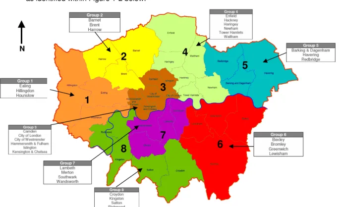
Phase 1 builds upon work undertaken during Tier 1 of the Drain London Project. The Tier 1 work involved the collection and review of surface water data from key stakeholders and the building of partnerships between key stakeholders responsible for local flood risk management. It was also decided that London would be delineated into 8 working groups. The LB of Hillingdon forms part of Group 1 along with the LB’s of Ealing and Hounslow.
The LB of Hillingdon has begun to establish a broader partnership with the Boroughs located within Group 2 (the LB of Barnet, Brent and Harrow), through the establishment of the North West London Strategic Flood Group, in order for these local authorities to determine best practice and resources to enable each authority to discharge their responsibilities as Lead Local Flood Authority (LLFA) under the Flood and Water Management Act (FWMA) 2010.
Phase 2 Risk Assessment
As part of Phase 2 Risk Assessment, direct rainfall modelling has been undertaken across the entire Borough for five specified return periods. The results of this modelling have been used to identify Local Flood Risk Zones (LFRZs) where flooding affects houses, businesses and/or infrastructure. Those areas identified to be at more significant risk have been delineated into Critical Drainage Areas (CDAs) representing one or several LFRZs as well as the contributing catchment area and features that influence the predicted flood extent.
Within the LB of Hillingdon, 17 CDAs have been identified; these are shown in Figure i (overleaf) – Figure 1 within Appendix D provides this image a t a larger resolution. The principal mechanisms for flooding in the LB of Hillingdon can be broadly divided into the following categories:
• River Valleys (current and historical) - Across the study area, the areas particularly susceptible to overland flow are formed by narrow corridors associated with topographical valleys which represent the routes of the ‘lost’ watercourses within London;
• Topographical Low Lying Areas - areas such as underpasses, subways and lowered roads beneath railway lines are more susceptible to surface water flooding;
• Railway Embankments - discrete surface water flooding locations along the up-stream side of the raised network rail embankment (running roughly west to east through the South of the Borough);
• Topographical Low Points – areas which are at topographical low points throughout the Borough which result in small, discrete areas of deep surface water ponding; and
• Sewer Flood Risk – areas where extensive and deep surface water flooding is likely to be the influence of sewer flooding mechanisms alongside pluvial and groundwater sources.
Figure i. Critical Drainage Areas within the London Borough of Hillingdon. N
Analysis of the number of properties at risk of flooding has been undertaken for the rainfall event with a 1 in 100 probability of occurrence in any given year. A review of the results demonstrate that 29,300 residential properties and 1,300 non-residential properties in the LB of Hillingdon could be at risk of surface water flooding of greater than 0.03m depth (above an assumed 0.1m building threshold) during a 1 in 100 year rainfall event.
A review of these statistics coupled with local knowledge of the study area identifies that the following CDAs, located within Table i, are at greatest risk of flooding in terms of the number of receptors at risk
Table i Critical Drainage Areas at greatest risk in London Borough of Hillingdon Infrastructure Households Commercial /
Industrial CDA ID All > 0.5m Deep All > 0.5m Deep All > 0.5m Deep Group1_027 4 1 1290 4 13 0 Group1_018 3 1 921 1 16 0 Group1_015 3 0 593 19 14 0 Group1_005 6 0 565 0 1 0 Group1_023 2 0 376 0 7 0 Group1_028 1 0 353 5 1 0
The majority of surface water flooding within the Borough is as a result of topographical low areas and obstructions to natural overland flowpaths, along with runoff within historical river valleys. Several rail lines are predicted to be at risk due to the elevations of the finished track being lower than the surrounding areas and within cuttings.
Three (3) CDAs have been identified as being cross boundary/borough, these are: CDA 005 which is cross boundary with the LB of Ealing and CDA’s 017 and 0027 with the LB of Harrow.
Phase 3 Options Assessment
There are a number of opportunities for measures to be implemented across the Borough to reduce the impact of surface water flooding. Ongoing maintenance of the drainage network and small scale improvements are already undertaken as part of the operations of the Borough. In addition, opportunities to raise community awareness of the risks and responsibilities for residents should be sought, and LB of Hillingdon may wish to consider the implementation of a Communication Plan to assist with this.
It is important to recognise that flooding within the Borough is not confined to just the CDAs, and therefore, throughout the borough there are opportunities for generic measures to be implemented through the establishment of a policy position on issues including the widespread use of water conservation measures such as water butts and rainwater harvesting technology, use of soakaways, permeable paving, bioretention car park pods and green roofs. In addition, there are borough-wide opportunities to raise community awareness.
For each of the CDAs identified within the borough, site-specific measures will be identified that could be considered to help alleviate surface water flooding. Work on clarifying the risks in priority areas has been started to allow options assessment, however as it is ongoing, these have not been included within this document.
Pluvial modelling undertaken as part of the SWMP has identified that flooding within the LB of Hillingdon is heavily influenced by existing and historic river valleys, and impacts a number of regionally important infrastructure assets.
There are a number of options that will be considered including:
• Engage with residents regarding the flood risk in the Borough, to make them aware of their responsibilities for property drainage (especially in the CDAs) and steps that can be taken to improve flood resilience;
• Provide an ‘Information Portal’ via the LB of Hillingdon website, for local flood risk information and measures that can be taken by residents to mitigate surface water flooding to/around their property;
• Prepare a Communication Plan to effectively communicate and raise awareness of surface water flood risk to different audiences using a clearly defined process for internal and external communication with stakeholders and the public; and
• Improve maintenance regimes, and target those areas identified to regular flood or known to have blocked gullies.
Phase 4 Implementation & Review
• Phase 4 will establish a long-term Action Plan for LB of Hillingdon to assist in their role under the FWMA 2010 to lead in the management of surface water flood risk across the borough. The SWMP Action Plan is a ‘living’ document, and as such, should be reviewed and updated regularly (recommended annually or greater), particularly following the occurrence of a surface water flood event, when additional data or modelling becomes available, following the outcome of investment decisions by partners and following any additional major development or changes in the catchment which may influence the surface water flood risk within the borough.
Glossary
Term Definition
Aquifer A source of groundwater comprising water bearing rock, sand or gravel capable of yielding significant quantities of water.
AMP Asset Management Plan, see below Asset
Management Plan
A plan for managing water and sewerage company (WaSC) infrastructure and other assets in order to deliver an agreed standard of service.
AStSWF Areas Susceptible to Surface Water Flooding. A national data set held by the Environment Agency and based on high level modelling which shows areas potentially at risk of surface water flooding.
Bank Full The flow stage of a watercourse in which the stream completely fills its channel and the elevation of the water surface coincides with the top of the
watercourses banks. Catchment Flood
Management Plan (CFMP)
A high-level planning strategy through which the Environment Agency works with their key decision makers within a river catchment to identify and agree policies to secure the long-term sustainable management of flood risk. CDA Critical Drainage Area, see below.
Critical Drainage Area
A discrete geographic area (usually a hydrological catchment) where multiple and interlinked sources of flood risk (surface water, groundwater, sewer, main river and/or tidal) cause flooding in one or more Local Flood Risk Zones during severe weather thereby affecting people, property or local infrastructure. CFMP Catchment Flood Management Plan, see entry above
CIRIA Construction Industry Research and Information Association Civil Contingencies
Act
This UK Parliamentary Act delivers a single framework for civil protection in the UK. As part of the Act, Local Resilience Forums have a duty to put into place emergency plans for a range of circumstances including flooding.
CLG Government Department for Communities and Local Government
Climate Change Long term variations in global temperature and weather patterns caused by natural and human actions.
Culvert A channel or pipe that carries water below the level of the ground. Defra Government Department for Environment, Food and Rural Affairs
DEM Digital Elevation Model: a topographic model consisting of terrain elevations for ground positions at regularly spaced horizontal intervals. DEM is often used as a global term to describe DSMs (Digital Surface Model) and DTMs (Digital Terrain Models).
Dendritic Irregular stream branching, with tributaries joining the main stream at all angles. e.g. drainage networks converge into larger trunk sewers and finally one outfall. DG5 Register A water-company held register of properties which have experienced sewer
flooding due to hydraulic overload, or properties which are 'at risk' of sewer flooding more frequently than once in 20 years.
DSM Digital Surface Model: a topographic model of the bare earth/underlying terrain of the earth’s surface including objects such as vegetation and buildings. DTM Digital Terrain Model: a topographic model of the bare earth/underlying terrain
of the earth’s surface excluding objects such as vegetation and buildings. DTMs are usually derived from DSMs.
EA Environment Agency, Government Agency reporting to DEFRA charged with protecting the Environment and managing flood risk in England.
Indicative Flood Risk Areas
Areas determined by the Environment Agency as potentially having a
significant flood risk, based on guidance published by Defra and WAG and the use of certain national datasets. These indicative areas are intended to provide a starting point for the determination of Flood Risk Areas by LLFAs.
Term Definition
FCERM Flood and Coastal Erosion Risk Management Strategy. Prepared by the Environment Agency in partnership with Defra. The strategy is required under the Flood and Water Management Act 2010 and will describe what needs to be done by all involved in flood and coastal risk management to reduce the risk of flooding and coastal erosion, and to manage its consequences.
FMfSW Flood Map for Surface Water. A national data set held by the Environment Agency showing areas where surface water would be expected to flow or pond, as a result of two different chances of rainfall event, the 1 in 30yr and 1 in 200yr events.
Flood defence Infrastructure used to protect an area against floods such as floodwalls and embankments; they are designed to a specific standard of protection (design standard).
Flood Risk Area See entry under Indicative Flood Risk Areas. Flood Risk
Regulations
Transposition of the EU Floods Directive into UK law. The EU Floods Directive is a piece of European Community (EC) legislation to specifically address flood risk by prescribing a common framework for its measurement and
management. Floods and Water
Management Act
An Act of Parliament which forms part of the UK Government's response to Sir Michael Pitt's Report on the Summer 2007 floods, the aim of which is to clarify the legislative framework for managing surface water flood risk in England. The Act was passed in 2010 and is currently being enacted.
Fluvial Flooding Flooding resulting from water levels exceeding the bank level of a watercourse (river or stream). In this report the term Fluvial Flooding generally refers to flooding from Main Rivers (see later definition).
FRR Flood Risk Regulations, see above.
IDB Internal Drainage Board. An independent body with powers and duties for land drainage and flood control within a specific geographical area, usually and area reliant on active pumping of water for it’s drainage.
iPEG Increased Potential Elevated Groundwater (iPEG) maps. The iPEG mapping shows those areas within the borough where there is an increased potential for groundwater to rise sufficiently to interact with the ground surface or be within 2 m of the ground surface. The mapping was carried out on a London-wide scale by Jacobs/JBA in March 2011.
IUD Integrated Urban Drainage, a concept which aims to integrate different methods and techniques, including sustainable drainage, to effectively manage surface water within the urban environment.
LB London Borough, e.g. LB Hillingdon, London Borough of Hillingdon
LDF Local Development Framework, is the spatial planning strategy introduced in England and Wales by the Planning and Compulsory Purchase Act 2004 and given detail in Planning Policy Statements 12. These documents typically set out a framework for future development and redevelopment within a local planning authority.
LFRZ Local Flood Risk Zone, see below. Local Flood Risk
Zone
Local Flood Risk Zones are defined as discrete areas of flooding that do not exceed the national criteria for a ‘Flood Risk Area’ but still affect houses, businesses or infrastructure. A LFRZ is defined as the actual spatial extent of predicted flooding in a single location
Lead Local Flood Authority
Local Authority responsible for taking the lead on local flood risk management. The duties of LLFAs are set out in the Floods and Water Management Act. LiDAR Light Detection and Ranging, a technique to measure ground and building
levels remotely from the air, LiDAR data is used to develop DTMs and DEMs (see definitions above).
Term Definition Local Resilience
Forum
A multi-agency forum, bringing together all the organisations that have a duty to cooperate under the Civil Contingencies Act, and those involved in responding to emergencies. They prepare emergency plans in a co-ordinated manner and respond in an emergency. Roles and Responsibilities are defined under the Civil Contingencies Act.
LPA Local Planning Authority, see below. Local Planning
Authority
The local authority or Council that is empowered by law to exercise planning functions for a particular area. This is typically the local Borough or district Council.
LRF Local Resilience Forum, see above.
Main River Main rivers are a statutory type of watercourse in England and Wales, usually larger streams and rivers, but also include some smaller watercourses. A main river is defined as a watercourse marked as such on a main river map, and can include any structure or appliance for controlling or regulating the flow of water in, into or out of a main river. The Environment Agency's powers to carry out flood defence works apply to main rivers only.
NRD National Receptor Dataset – a collection of risk receptors produced by the Environment Agency. A receptor could include essential infrastructure such as power infrastructure and vulnerable property such as schools and health clinics. Ordinary
Watercourse
All watercourses that are not designated Main River, and which are the responsibility of Local Authorities or, where they exist, IDBs are termed Ordinary Watercourses.
PA Policy Area, see below.
Partner A person or organisation with responsibility for the decision or actions that need to be taken.
PFRA Preliminary Flood Risk Assessment, see below.
Pitt Review Comprehensive independent review of the 2007 summer floods by Sir Michael Pitt, which provided recommendations to improve flood risk management in England.
Pluvial Flooding Flooding from water flowing over the surface of the ground; often occurs when the soil is saturated and natural drainage channels or artificial drainage systems have insufficient capacity to cope with additional flow.
Policy Area One or more Critical Drainage Areas linked together to provide a planning policy tool for the end users. Primarily defined on a hydrological basis, but can also accommodate geological concerns where these significantly influence the implementation of SuDS
PPS25 Planning and Policy Statement 25: Development and Flood Risk Preliminary Flood
Risk Assesment
Assessment required by the EU Floods Directive which summarises flood risk in a geographical area. Led LLFAs.
Resilience Measures
Measures designed to reduce the impact of water that enters property and businesses; could include measures such as raising electrical appliances. Resistance
Measures
Measures designed to keep flood water out of properties and businesses; could include flood guards for example.
Risk In flood risk management, risk is defined as a product of the probability or likelihood of a flood occurring, combined with the consequence of the flood. Risk Management
Authority
As defined by the Floods and Water Management Act. These can be (a) the Environment Agency,(b) a lead local flood authority, (c) a district council for an area for which there is no unitary authority, (d) an internal drainage board,(e) a water company, and (f) a highway authority.
RMA Risk Management Authority, see above
Sewer flooding Flooding caused by a blockage or overflowing in a sewer or urban drainage system.
Term Definition
Stakeholder A person or organisation affected by the problem or solution, or interested in the problem or solution. They can be individuals or organisations, includes the public and communities.
Strategic Flood Risk Assessment
SFRAs (SFCAs in Wales) are prepared by local planning authorities (in consultation with us) to help guide local planning. They allow them to
understand the local risk of flooding from all sources (including surface water and groundwater). They include analysis and maps of the impact of climate change on the extent of future floods. You can find these documents on the website of your local planning authority.
SuDS Sustainable Drainage Systems, see below. Sustainable
Drainage Systems
Methods of management practices and control structures that are designed to drain surface water in a more sustainable manner than some conventional techniques. Includes swales, wetlands, bioretention devices and ponds. Surface water Rainwater (including snow and other precipitation) which is on the surface of
the ground (whether or not it is moving), and has not entered a watercourse, drainage system or public sewer.
SWMP Surface Water Management Plan
TE2100 The Thames Estuary 2100 Project. Led by the Environment Agency, the project was established in 2002 with the aim of developing a long-term tidal flood risk management plan for London and the Thames estuary.
TfL Transport for London
TWUL Thames Water Utilities Ltd
UKCIP The UK Climate Impacts Programme. Established in 1997 to assist in the co-ordination of research into the impacts of climate change. UKCIP publishes climate change information on behalf of the UK Government and is largely funded by Defra.
Table of Contents
ACKNOWLEDGEMENTS ... II EXECUTIVE SUMMARY... III GLOSSARY ... VII TABLE OF CONTENTS... XI
1 INTRODUCTION... 1
1.1 WHAT IS A SURFACE WATER MANAGEMENT PLAN?... 1
1.2 BACKGROUND... 1
1.3 SWMP PROCESS... 3
1.4 OBJECTIVES... 4
1.5 STUDY AREA... 5
1.6 FLOODING INTERACTIONS... 12
1.7 LINKAGES WITH OTHER PLANS... 13
1.8 EXISTING LEGISLATION... 15 1.9 PEER REVIEW. ... 16 1.10 LLFA RESPONSIBILITIES... 17 2 PHASE 1: PREPARATION ... 18 2.1 PARTNERSHIP... 18 2.2 DATA COLLECTION... 18 2.3 DATA REVIEW... 21
2.4 SECURITY, LICENSING AND USE RESTRICTIONS... 22
2.5 LLFA ASSET REGISTER REQUIREMENTS... 23
2.6 REVIEW OF ASSET MANAGEMENT SYSTEMS... 24
3 PHASE 2: RISK ASSESSMENT ... 25
3.1 INTERMEDIATE ASSESSMENT... 25
3.2 RISK OVERVIEW... 26
3.3 SURFACE WATER FLOODING... 27
3.4 ORDINARY WATERCOURSE FLOODING... 30
3.5 GROUNDWATER FLOODING... 33
3.6 SEWERS... 36
3.7 OTHER FACTORS EFFECTING FLOODING... 39
3.8 CRITICAL DRAINAGE AREAS... 39
3.9 SUMMARY OF RISK... 55
4 PHASE 3: OPTIONS ... 56
4.1 OBJECTIVES... 56
4.2 MEASURES... 56
4.3 PROPOSED SURFACE WATER DRAINAGE POLICY... 59
5 PHASE 4: IMPLEMENTATION AND REVIEW ... 60
5.1 ACTION PLAN... 60
5.2 REVIEW TIMEFRAME AND RESPONSIBILITIES... 62
5.3 ONGOING MONITORING... 62
5.4 INCORPORATING NEW DATASETS... 63
5.5 UPDATING SWMP REPORTS AND FIGURES... 63
TABLES
Table 1-1 Summary of Drain London Project ‘Tier’ Structure ... 2
Table 2-1 Data Sources and Use ... 19
Table 2-2 Asset Register (source: Defra, 2011 Lead Local Flood Authority Duty to Maintain a Register) ... 23
Table 3-1: SWMP Study Levels of Assessment [Defra 2010]... 25
Table 3-2: Records of Surface Water Flooding ... 28
Table 3-3: Watercourses in the London Borough of Hillingdon... 31
Table 3-4: Records of Groundwater Flooding ... 34
Table 3-5: Number of Thames Water sewer flood records within the London Borough of Hillingdon .. 37
Table 3-6 Legend for Hazard Rating Figures ... 42
Table 3-1: Summary of Surface Water Flood Risk in CDAs in the London Borough of Hillingdon... 55
Table 4-1 Typical Surface Water Flood Risk Management Measures... 59
Table 5-1 Summary of Actions within the Action Plan ... 61
FIGURES Figure 1-1 Drain London Project ‘Tier’ Structure... 2
Figure 1-3 Recommended Defra SWMP Process (Source Defra 2010)... 4
Figure 1-4 Land Uses within the London Borough of Hillingdon ... 6
Figure 1-5 Main Watercourses within Hillingdon ... 9
Figure 1-6 LiDAR Representation of the Topography within Hillingdon... 10
Figure 1-7 Proposed Strategic Flood Risk Management Boards... 12
Figure 1-8 Illustration of Flood Sources (source: WSP, 2010)... 13
Figure 1-9 Linkages of LFRM Strategy Reports... 15
Figure 1-10 Where the SWMP is located within the delivery of local flood and coastal risk management ... 16
Figure 3-1: Model coverage for the London Borough of Hillingdon ... 29
Figure 3-2 Example Critical Drainage Area (CDA) and Local Flood Risk Zone (LFRZ) ... 40
Figure 3-3 Critical Drainage Areas Locations within Hillingdon ... 41
Figure 3-4 Combinations of flood depth and velocity that cause danger to people (Source: DEFRA/Environment Agency research on Flood Risks to People - FD2321/TR2) ... 42
Figure 4-1 Illustration of Sources, Pathways & Receptors (extracted from SWMP Technical Guidance, Defra 2010) ... 57
Figure 4-2 Source, Pathway and Receptor Model (adapted from Defra SWMP Technical Guidance, 2010) ... 58 Appendix A Data Review
Appendix B Asset Register Recommendation Appendix C Risk Assesssment Technical Details Appendix C1 Surface water Modelling
Appendix C2 Groundwater Appendix D Maps
Appendix E peer Review
Appendix F Spatial Planner Information Pack
1 Introduction
1.1 What is a Surface Water Management Plan?
1.1.1 A Surface Water Management Plan (SWMP) is a plan produced by the Lead Local Flood Authority (in this case London Borough of Hillingdon) which outlines the preferred surface water management strategy in a given location. In this context surface water flooding describes flooding from sewers, drains, groundwater, and runoff from land, small water courses and ditches that occurs as a result of heavy rainfall.
1.1.2 This SWMP study has been undertaken as part of the Drain London Project in consultation with key local partners who are responsible for surface water management and drainage in the London area – including Thames Water, the Environment Agency and Transport for London. The Partners have worked together to understand the causes and effects of surface water flooding and agree the most cost effective way of managing surface water flood risk for the long term.
1.1.3 The finalised SWMP will establish a long-term action plan to manage surface water and will influence future capital investment, maintenance, public engagement and understanding, land-use planning, emergency planning and future developments.
1.2 Background
1.2.1 In May 2007 the Mayor of London consulted on a draft Regional Flood Risk Appraisal (RFRA). One of the key conclusions was that the threat of surface water flooding in London was poorly understood. This was primarily because there were relatively few records of surface water flooding and those that did exist were neither comprehensive nor consistent. Furthermore the responsibility for managing flood risk in London is split between Boroughs and other organisations such as Transport for London, London Underground, Network Rail and relationships with the Environment Agency and Thames Water and the responsibility for managing sources of flood risk were unclear. To give the issue even greater urgency it is widely expected that heavy storms with the potential to cause flooding will increase in frequency with climate change.
1.2.2 The Greater London Authority, London Councils, Environment Agency and Thames Water commissioned a scoping study to test these findings and found that this was an accurate reflection of the situation. The conclusions were brought into sharp focus later in the summer of 2007 when heavy rainfall resulted in extensive surface water flooding in parts of the UK such as Gloucestershire, Sheffield and Hull causing considerable damage and disruption. It was clear that a similar rainfall event in London would have resulted in major disruption. The Pitt Review examined the flooding of 2007 and made a range of recommendations for future flood management, most of these have been enacted through the Flood and Water Management Act 2010 (FWMA).
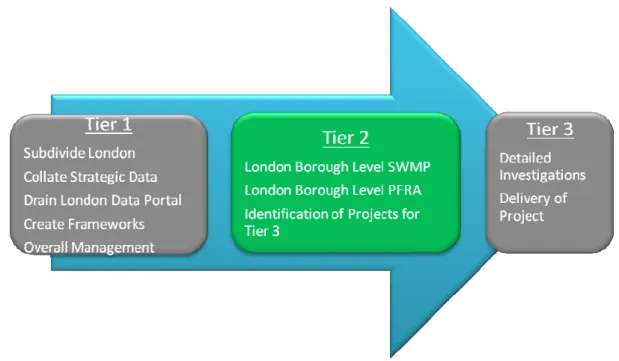
1.2.3 The Department for Environment, Food and Rural Affairs (Defra) recognised the importance of addressing surface water flooding in London and fully funded the Drain London project. The Drain London project is being delivered through 3 ‘Tiers’ as shown in Figure 1-1 and described in Table 1-1. This SWMP form part of Tier 2 package of works.
Figure 1-1 Drain London Project ‘Tier’ Structure
1.2.4 Figure 1-1 provides a summary of the work undertaken within each Tier (phase) of the Drain London Project.
Table 1-1 Summary of Drain London Project ‘Tier’ Structure
Phase Summary of works
Ti
e
r
1
a) A high level strategic investigation to group the 33 separate boroughs into a smaller number of more manageable units for further study under Tiers 2 and 3. b) Collection and collation of relevant information across all London Boroughs and strategic stakeholders including the Environment Agency, Thames Water and Transport for London.
c) Development of a web based ‘Portal’ to provide data management, data storage and access to the various data sets and information across the ‘Drain London Forum’ (DLF) participants and to consultants engaged to deliver Tiers 2 and 3. d) Develop technical framework documents and prioritisation tools to guide
delivery of Tiers 2 and 3.
Ti
e
r
2
a) Delivery of 33 Borough-level intermediate Surface Water Management Plans (SWMPs) within the management groups to define and map Local Flood Risk Zones, Critical Drainage Areas and flood policy areas and produce an Action Plan for each borough.
b) Delivery of 33 Borough-level Preliminary Flood Risk Assessments to comply with the Flood Risk Regulations 2009 requirements for Lead Local Flood Authorities (LLFAs).
c) Define a list of prioritised Critical Drainage Areas for potential further study or capital works in Tier 3, using the prioritisation tool developed in Tier 1.
Ti
e
r
3
a) Further investigations into high priority Local Flood Risk Zones/Critical Drainage Areas to further develop and prioritise mitigation options.
b) Delivery of demonstration projects of surface water flood mitigation solutions identified in Tier 2 SWMPs.
c) Funding or co-funding within the London area for green roofs and other types of sustainable urban drainage (SUDS).
d) Set up of at least 2 community flood plans in local communities at risk from flooding
1.2.5 As described in Table 1-1, Tier 2 of the Drain London project involves the preparation of SWMPs for each London Borough (LB). Through the subsequent enactment of the FWMA Boroughs are also required to produce Preliminary Flood Risk Assessments (PFRA). The Drain London project has been extended to deliver both a PFRA and a SWMP for each London Borough. This will be a major step in meeting Borough requirements as set out in the F&WM Act. Another key aspect of the Act is to ensure that Boroughs work in partnership with other Local Risk Authorities. Drain London assists this by creating sub-regional partnerships as identified within Figure 1-2 below.
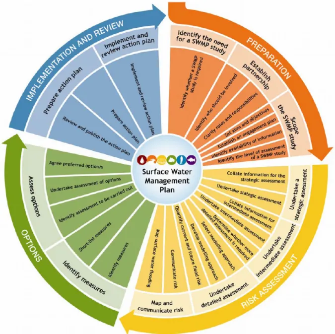
1.3 SWMP Process
1.3.1 The Defra SWMP Technical Guidance (2010) provides the framework for preparing SWMPs. This report has been prepared to reflect the four principal stages identified by the guidance (refer Figure 1-3, overleaf):
• Preparation; Identify the need for a SWMP, establish a partnership with the relevant stakeholders and scope SWMP (refer to Section 2);
• Risk Assessment; Identify which level of detail is required for the SWMP – a Level 2 Intermediate assessment was selected for this study (refer to Section3);
• Options: Identify options/measures (with stakeholder engagement) which seek to alleviate the surface water flood risk within the study area (refer to Section 4); and
• Implementation and Review: Prepare Action Plan and implement the monitoring and review process for these actions (refer to Section 5).
1
2
3
4
5
6
7
8
NFigure 1-3 Recommended Defra SWMP Process (Source Defra 2010)
1.3.2 The scope of the Tier 2 work (refer to Table 1-1) falls mainly within Phase 2 (Risk Assessment) providing the evidence base. Phase 3 (Options) and Phase 4 (Implementation and Review) will be provided in the second part of the plan.
1.4 Objectives
1.4.1 The objectives of the whole SWMP process are to: 1.4.2 Phase 1
• Establish and consolidate partnerships between key drainage stakeholders to facilitate a collaborative culture of data, skills, resource and learning sharing and exchange, and closer coordination to utilise cross boundary working opportunities;
• Develop a robust understanding of surface water flood risk in and around the study area, taking into account the challenges of climate change, population and demographic change and increasing urbanisation in London;
• Identify, define and prioritise Critical Drainage Areas, including further definition of existing local flood risk zones and mapping new areas of potential flood risk;
• Borough specific aims and objectives identified included :
• Identify surface water flood risk areas to assist with spatial planning and future development; • Identify surface water flood risk areas to assist with emergency planning within the Borough; • Provision of mapping which is suitable for public distribution;
Undertake engagement with stakeholders to raise awareness of surface water flooding, identify flood risks and assets
1.4.4 Phase 3
• Facilitate discussions and report implications relating to wider issues falling outside the remit of this Tier 2 work, but deemed important by partners and stakeholders for effectively fulfilling their responsibilities and delivering future aspects of flood risk management.
• Make holistic and multifunctional recommendations for surface water management which improve emergency and land use planning, and enable better flood risk and drainage infrastructure investments;
• Determine (if possible) options to alleviate flood risk within the identified Critical Drainage
Areas;
1.4.5 Phase 4
• Deliver outputs to enable a real change on the ground whereby partners and stakeholders take ownership of their flood risk and commit to delivery and maintenance of the recommended measures and actions;
• Provide a clear Action Plan which the Council can implement (and/or areas to investigate) to assist in the further understanding of pluvial and groundwater flooding within the Borough.
1.5 Study Area
Location and Characteristics
1.5.1 The London Borough (LB) of Hillingdon is located in west London. The Borough borders the London Boroughs of Ealing and Harrow to the east, Hounslow to the south-east, Richmond upon Thames to the south. South Bucks District Council is located along the majority of the Boroughs western boundary whilst Three Rivers District Council is located along the northern boundary and Slough District Council along the southwest.
1.5.2 The Borough boundary encompasses an area of 11,530ha (115.3km2) and contains a mixture of urban and open space landuses. The borough has a distinctive character with its combination of suburban streets and shopping centre’s, industrial land, major office developments and large areas of open land, historic woodland and inland waterways including 4,960 hectares of Green Belt. The majority of the urban extent is located within the north east and central portions of the borough. Figure 1-4 (and Figure 3, within Appendix D), overleaf,
1.5.3 The Borough contains the following significant infrastructure: • Heathrow Airport is located within the south of the Borough;
• Network Rail and London underground rail lines along with tube/rail stations and rail assets and infrastructure;
• Five hospitals; and
• Two (2) motorways and thirteen (13) arterial roads.
Figure 1-4 Land Uses within the London Borough of Hillingdon N
Major Rivers and Waterways within the Borough
1.1.1 The following watercourse are located within the boundaries of the Borough:
• River Colne (including the tributaries of the Frays River and New Years Greene Bourne);
• River Crane (including the Yeading Brook); • River Pinn;
• Duke of Northumberland River & Longford River; • Grand Union Canal;
River Colne
1.1.2 The River Colne is one of the major rivers in the Borough. The River Colne forms the western boundary in the north of the Borough. The Colne is often referred to in two sections; the Upper Colne and the Lower Colne system differentiated by Denham Weir. The Upper Colne is predominantly rural land use and the Lower Colne can be considered urban. The Colne is a very complex river system with large reservoirs used to store potable supply water for Greater London. The Frays River and the River Pinn form some of the major tributaries into the River Colne.
Yeading Brook
1.1.3 The Yeading Brook flows into the Borough of Hillingdon from the east through two principle branches the east and west arm.
1.1.4 The Yeading Brook East arm enters Hillingdon through a long culvert at Field End Road (National Grid Reference 512340, 185690) before surfacing again to the southwest of Victoria Retail Park (National Grid Reference 511721, 185382). The Eastern arm flows in a south-westerly direction for 3.6km through South Ruislip and then west along the southern boundary of Northolt Aerodrome before its confluence with the West arm (at National Grid Reference 549950, 184190).
1.1.5 The Yeading Brook West arm enters Hillingdon through Ruislip recreation ground and flows in parallel with the East arm in a south-westerly direction for 5km, until its confluence with the Ickenham Stream to the south. The West arm then flows for 1.7km through rural pasture before its confluence with the East arm at National Grid Reference 509950, 184190. The Yeading Brook main branch then flows south for 7.6km passing through green open space to the southeast of Yeading and the easterly edge of Hayes. Of this 7.6km length the Yeading Brook travels in parallel with the Grand Union Canal for 2.5km before flowing under an Aqueduct becoming the River Crane at Craneford Park.
River Crane
1.1.6 The Yeading Brook changes its name to the River Crane at Hayes, north of the M4 to the south of the Grand Union Canal and before flowing under the M4 into Cranford Park. The River Crane continues to flow through green open space in a southerly direction for 2km before it is joined by the small tributary Frog’s Ditch. The Crane then flows for 1.7km into the Heathrow Airport grounds before flowing out into the neighbouring Borough of Hounslow.
Duke of Northumberland River & Longford River
1.1.7 The Duke of Northumberland River and Longford River are two channels that split from the River Colne at Harmondsworth (National Grid Reference 505350, 178160). The Duke of Northumberland River is an artificial channel and is one of the main tributaries of the River Crane. It consists of two sections; the Harmondsworth or Western Section and the Mogden or Eastern Section. The Duke of Northumberland River flows in a southerly direction before turning in an easterly direction to form the southern border of the Borough along the perimeter of Heathrow airport before flowing into the Borough of Hounslow, running in parallel to the Longford River. As part of the Terminal 5 development this watercourse has been slightly diverted.
The Grand Union Canal
1.1.8 The Grand Union Canal enters the Borough near (NGR 515940, 178720) and travels in a southerly direction through the Borough before connecting to the River Thames at Brentford via the Thames Lock and Brentford Dock (NGR 517840, 177290). The Grand Union Canal has two branches within the Borough of Hillingdon to the east and west. The westerly branch of the Grand Union Canal runs from the north of the Borough in parallel with the Upper Colne, through the Borough to Yiewsley, before turning east and travelling across the Borough through Hayes and on to Bull’s Bridge. Here it joins with the easterly branch, known as the Paddington Branch.
1.1.9 It is recommended that the reader refers to the LB Hillingdon Strategic Flood Risk Assessment (available from the planning section of the council website) for additional information relating to these watercourse
Figure 1-5 Main Watercourses within Hillingdon
(source: Scott Wilson 2008, London Borough of Hillingdon SFRA) N
Topography and Geology
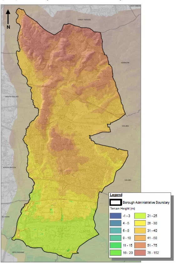
1.5.4 Figure 1-6 (below) identifies the general elevations within the Borough.
Figure 1-6 LiDAR Representation of the Topography within Hillingdon
1.5.5 Figure 1-6 indicates that the highest elevations within the Borough are in the north of the Borough, between Harefield, Ruislip and North Wood with areas of high ground located near Hillingdon. Figure whilst the lowest elevations can be located in the south of the borough near Heathrow Airport.
1.5.6 The dominant solid geology for the LB of Hillingdon is the London Clay Formation. Outcrops of the Lambeth group are located within river valleys near the north of the borough (around Ruislip and Northwood). Along the western boundary of the borough some areas of Chalk are located near the River Colne.
1.5.7 Drift deposits overlying the solid geology in the southern area of the district consist of pockets of Langley Silt (sandy clay and silt ‘brick earth’) overlying the River Terraced Deposits (mainly gravels), which have been locally excavated creating lakes and reservoirs where they have not been backfilled and areas of in-filled ground where they have.
1.5.8 Within the vicinity of West Drayton, Langley silt is found to extensively overlie the gravels. In the northern part of the district (Hillingdon and further north) drift deposits are limited to pockets of Glacial Sand and Gravel, which includes undifferentiated head (the glacial deposits will consist mainly of sands and gravels and the head deposits of sandy clay and silt). Along the line of river channels, alluvial deposits are located and in some areas the underlying solid formation has been exposed.
1.5.9 Figure 12, within Appendix D, provides an overview of the geology within the borough. Significant future development plans
1.5.10 The Local Development Framework (LDF) for the London Borough of Hillingdon identifies a number of growth areas with a focus on: Uxbridge, Yeading, West Drayton, Hayes and the Heathrow Opportunity Area
1.5.11 It is recommended that the Borough utilise the SWMP, PFRA and the SFRA to develop the most suitable locations for future development. These assessments will also be used in the decision making process for new development proposals.
Interactions with neighbouring Boroughs / County Councils
1.5.12 The Environment Agency has proposed Strategic Flood Risk Management Boards within Greater London to coordinate Flood Risk Management. The Council is member of a partnership for flood risk management with the following London Boroughs:
• Ealing; • Hounslow; • Harrow; • Brent; and • Barnet.
1.5.13 Figure 1-7 identifies the boundary of the West London Flood Risk Management Board, which include the LB of Hillingdon.
Figure 1-7 Proposed Strategic Flood Risk Management Boards
1.5.14 The group is is currently developing a Terms of Reference but in summary the purpose of this partnership to;
• Understand flood risk within the group Boroughs;
• Share best practise management between the Councils; and • Create a forum to address cross Borough drainage issues.
1.6 Flooding Interactions
1.6.1 The SWMP technical guidance (Defra 2010) identifies four primary sources of surface water flooding that should be considered within a SWMP as described below:
•
Pluvial flooding; high intensity storms (often with a short duration) are sometimes unable to infiltrate into the ground or be drained by formal drainage systems since the capacity of the collection systems is not large enough to convey runoff to the underground pipe systems (which in turn might already be surcharging). The pathway for pluvial flooding can include blockage, restriction of flows (elevated grounds), overflows of the drainage system and failure of sluice outfalls and pump systems.• Sewer flooding; flooding which occurs when the capacity of the underground drainage network is exceeded, resulting the surcharging of water into the nearby environment (or within internal and external building drainage networks). The discharge of the drainage network into waterways and rivers can also be affected if high water levels in receiving waters obstruct the drainage network outfalls.
• Ordinary Watercourses: flooding from small open channels and culverted urban watercourses (which receive most of their flow from the urban areas) can either exceed their capacity and cause localised flooding of an area or can be obstructed (through debris or illegal obstruction) and cause localised out of bank flooding of nearby low lying areas.
• Groundwater flooding occurs when the water level within the groundwater aquifer rises to the surface. In very wet winters these rising water levels may lead to flooding of areas that are normally dry. This can also lead to streams that only flow for part of the year being reactivated. These intermittent streams are typically known as bournes. Water levels below the ground can rise during winter (dependant on rainfall) and fall during drier summer months as water discharges from the saturated ground into nearby watercourses.
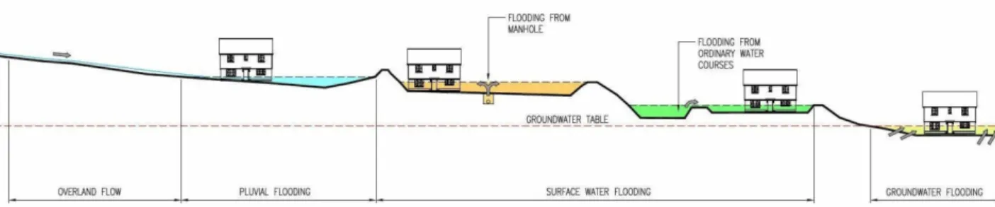
1.6.2 Figure 1-8 provides an illustration of these flood sources. Each of these sources of flood risk a futher explained within Section 2.
Figure 1-8 Illustration of Flood Sources (source: WSP, 2010).
1.7 Linkages with Other Plans
1.7.1 The increased focus on flood risk over recent years is an important element of adaptation to climate change. The clarification of the role of London Boroughs as Lead Local Flood Authorities (LLFA) is welcomed. The creation of a number of new documents can at times be confusing. Drain London links into all of these:
Regional Flood Risk Appraisal (RFRA)
1.7.2 The RFRA is produced by the Greater London Authority and gives a regional overview of flooding from all sources. The RFRA will be updated in 2012 to reflect the additional information on local sources of flood risk (surface water, groundwater and Ordinary Watercourses) from Drain London. This may also generate new policies that would be incorporated into the London Plan when it is reviewed.
Thames Catchment Flood Management Plan (CFMP)
1.7.3 The Thames Catchment Flood Management Plan (CFMP) was published in 2008 by the Environment Agency and sets out policies for the sustainable management of flood risk across the whole of the Thames catchment over the long-term (50 to 100 years) taking climate change into account. More detailed flood risk management strategies for individual rivers or sections of river may sit under these.
1.7.4 The CFMP emphasises the role of the floodplain as an important asset for the management of flood risk, the crucial opportunities provided by new development and regeneration to manage risk, and the need to re-create river corridors so that rivers can flow and flood more naturally.
1.7.5 This CFMP will be periodically reviewed, approximately five years from when it was published, to ensure that it continues to reflect any changes in the catchment. There are links to Drain London where there are known interactions between surface water and fluvial flooding
Preliminary Flood Risk Assessment (PFRA)
1.7.6 These are required as part of the Flood Risk Regulations which implement the requirements of the European Floods Directive. Drain London is producing one of these for each London Borough (each of which is a Lead Local Flood Authority), to give an overview of all local sources of flood risk. In London the PFRA process is greatly assisted by the new data and information relating to surface water which comes from the Drain London SWMPs. Boroughs must review these PFRAs every 6 years.
Surface Water Management Plans (SWMP)
1.7.7 Drain London is producing one of these for each London Borough. They provide detailed information on the potential for surface water flooding, based on probabilistic 2-dimensional modelling. This information improves greatly on data which has previously been provided at a national scale by the Environment Agency. In addition each SWMP contains an Action Plan that has been developed in conjunction with both the Borough and relevant other Risk Management Authorities. This data and actions and associated policy interventions will feed directly into the operational level of the Borough across many departments, in particular into spatial and emergency planning policies and designations and into the management of local authority controlled land.
Strategic Flood Risk Assessments (SFRA)
1.7.8 Each local planning authority is required to produce a SFRA under Planning Policy Statement 25 (PPS25). This provides an important tool to guide planning policies and land use decisions. Current SFRAs have a strong emphasis on flooding from main rivers and the sea and are relatively weak (due to past priorities and a lack of data) in evaluating flooding from other local sources including surface water, groundwater and Ordinary Watercourses. The information from Drain London will improve this understanding.
1.7.9 Currently a Level 1 SFRA has been produced for the Borough. This was completed in November 2011 with the intention that it will be updated periodically to reflect the latest flood risk information. This document can be obtained from the LB of Hillingdon website.
Local Development Documents (LDD)
1.7.10 LDDs including the Core Strategy and relevant Area Action Plans (AAPs) will need to reflect the results from Drain London. This may include policies for the whole Borough or for specific parts of Boroughs, for example Critical Drainage Areas. There may also be a need to review Area Action Plans where surface water flood risk is a particular issue. The updated SFRA will assist with this as will the reviewed RFRA and any updated London Plan policies. In producing Opportunity Area Planning Frameworks, the GLA and Boroughs will also examine surface water flood risk more closely.
Local Flood Risk Management Strategies
1.7.11 The Flood and Water Management Act 2010 (FWMA) requires each LLFA to produce a Local Flood Risk Management Strategy by December 2012. Whilst Drain London will not directly deliver a LFRMP, the SWMPs, PFRAs and their associated risk maps will provide the necessary evidence base to support the development of LFRMS and it is anticipated that no, or limited new modelling will be necessary to produce these strategies.
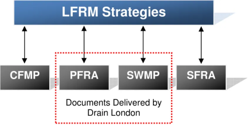
1.7.12 The schematic diagram (Figure 1-9 below) illustrates how the CFMP, PFRA, SWMP and SFRA link to and underpin the development of a Local Flood Risk Management Strategy.
Figure 1-9 Linkages of LFRM Strategy Reports
1.8 Existing Legislation
1.8.1 The Flood and Water Management Act 2010 (FWMA) presents a number of challenges for policy makers and the flood and coastal risk management authorities identified to co-ordinate and deliver local flood risk management (surface water, groundwater and flooding from ordinary water courses). ‘Upper Tier’ local authorities have been empowered to manage local flood risk through new responsibilities for flooding from surface and groundwater.
1.8.2 The FWMA reinforces the need to manage flooding holistically and in a sustainable manner. This has grown from the key principles within Making Space for Water (Defra, 2005) and was further reinforced by the summer 2007 floods and the Pitt Review (Cabinet Office, 2008). It implements several key recommendations of Sir Michael Pitt’s Review of the Summer 2007 floods, whilst also protecting water supplies to consumers and protecting community groups from excessive charges for surface water drainage.
1.8.3 The FWMA must also be considered in the context of the EU Floods Directive, which was transposed into law by the Flood Risk Regulations 2009 (the Regulations) on 10 December 2009. The Regulations requires three main types of assessment / plan to be produced:
a) Preliminary Flood Risk Assessments (maps and reports for Sea, Main River and Reservoir flooding) to be completed by Lead Local Flood Authorities and the Environment Agency by the 22 December 2011. Flood Risk Areas, at potentially significant risk of flooding, will also be identified. Maps and management plans will be developed on the basis of these flood risk areas.
b) Flood Hazard Maps and Flood Risk Maps. The Environment Agency and Lead Local Flood Authorities are required to produce Hazard and Risk maps for Sea, Main River and Reservoir flooding as well as ‘other’ relevant sources by 22 December 2013.
c) Flood Risk Management Plans. The Environment Agency and Lead Local Flood Authorities are required to produce Flood Risk Management Plans for Sea, Main River and Reservoir flooding as well as ‘other’ relevant sources by 22 December 2015.
LFRM Strategies
CFMP
PFRA
SWMP
SFRA
Documents Delivered by Drain London
1.8.4 Figure 1-10, overleaf, illustrates how this SWMP fits into the delivery of local flood and coastal risk management, and where the responsibilities for this lie.
Figure 1-10 Where the SWMP is located within the delivery of local flood and coastal risk management
1.9 Peer Review.
1.9.1 It is essential for the Drain London Project that SWMPs are consistent and comparable across Greater London. This is to facilitate:
• Fair, transparent and rapid allocation of funds to identified high priority flood risk areas within London;
• Collaborative working practices between stakeholders; and
Environment Agency (National Strategy)
Produce a National Strategy for FCERM as part of full strategic overview role for all FCERM (Main river, Ordinary Watercourse, sea water, surface run-off, groundwater, coastal erosion and flood risk from reservoirs). Support lead local authorities and others in FCERM by providing information and guidance on fulfilling their roles.
Defra
Flood and Coastal Erosion Risk Policy
Lead Local Flood Authorities – Local Strategies surface water, groundwater, Ordinary
Watercourses O v e rv ie w P la nni ng PFRAs SWMPs CFMPs SMPs D e li v e ry
LLFAs - surface water and groundwater
EA – Main River and the Sea
Water companies, reservoir owners, highways authorities
• Building of local capability (Council officers and consultants doing work in the future will be able to make use of outputs regardless of who produced them for each Borough).
1.9.2 To ensure consistency and comparability between London Borough SWMPs produced, a Peer Review process has been used. The process involved the four consultant teams who are working on the Drain London SWMPs independently reviewing each others work. This has ensured that all outputs result from a consistent technical approach, are of a high technical quality and are communicated in the specified formats. The peer review report for this SWMP is included in Appendix E.
1.10 LLFA Responsibilities
1.1.10 Aside from forming partnerships and coordinating and leading on local flood management, there are a number of other key responsibilities that have arisen for Local Lead Flood Authorities from the Flood & Water Management Act 2010, and the Flood Risk Regulations 2009. These responsibilities include:
• Investigating flood incidents – LLFAs have a duty to investigate and record
details of significant flood events within their area. This duty includes identifying which authorities have flood risk management functions and what they have done or intend to do with respect to the incident, notifying risk management authorities where necessary and publishing the results of any investigations carried out. .
• Asset Register – LLFAs also have a duty to maintain a register of structures or features which are considered to have an effect on flood risk, including details on ownership and condition as a minimum. The register must be available for inspection and the Secretary of State will be able to make regulations about the content of the register and records.
• SuDS Approving Body – LLFAs are designated the SuDS Approving Body (SAB)
for any new drainage system, and therefore must approve, adopt and maintain any new sustainable drainage systems (SuDS) within their area. This responsibility is anticipated to commence from April 2012.
• Flood risk management strategies – LLFAs are required to develop, maintain,
apply and monitor a strategy for local flood risk management in its area. The local strategy will build upon information such as national risk assessments and will use consistent risk based approaches across different local authority areas and catchments.
• Works powers – LLFAs have powers to undertake works to manage flood risk from surface runoff and groundwater, consistent with the local flood risk management strategy for the area.
• Designation powers – LLFAs, as well as district councils and the Environment
Agency have powers to designate structures and features that affect flooding in order to safeguard assets that are relied upon for flood risk management.
1.10.1 These LLFA requirements have been considered in the production of this document. The SWMP will assist the LLFA in providing evidence for points 1, 2 and 3.
2 Phase 1: Preparation
2.1 Partnership
2.1.1 The Flood and Water Management Act 2010 defines the Lead Local Flood Authority (LLFA) for an area as the unitary authority for the area, in this case the LB of Hillingdon. As such, the LB of Hillingdon is responsible for leading local flood risk management including establishing effective partnerships with stakeholders such as the Environment Agency, Thames Water Utilities Ltd, Transport for London, Network Rail and London Underground as well as others. Ideally these working arrangements should be formalised to ensure clear lines of communication, mutual co-operation and management through the provision of Level of Service Agreements (LoSA) or Memorandums of Understanding (MoU). It is recommended that the partnerships created as part of the Drain London Tier 1 work are maintained into perpetuity.
2.1.2 The LB of Hillingdon forms part of the Drain London ‘Group 1’ group of Boroughs, established as part of the Drain London programme, formed to assist delivery of Drain London, but also to establish an ongoing working partnership for managing local flood risk in the area. Drain London Group 1 includes the London Boroughs of Hillingdon, Ealing and Hounslow.
2.1.3 Currently Group 1 are represented on the Thames Regional Flood Defence Committee (RFDC) by the councillor from the LB of Hounslow.
2.1.4 At a Borough level, Hillingdon has set up a Flood Working Group in response to the Flood and Water Management Act, which includes departmental representatives from strategic planning, emergency planning, drainage and highways, in recognition of the cross-department input require on managing local flood risk.
2.1.5 Members of the public also have valuable information to contribute to the SWMP and to an improved understanding and management of local flood risk within the Borough. Public engagement can afford significant benefits to local flood risk management by gaining access to additional local knowledge, building trust, and increasing the chances of stakeholder acceptance of options and decisions proposed in future flood risk management plans.
2.2 Data Collection
2.2.1 The collection and collation of strategic level data was undertaken as part of the Drain London Tier 1 work and disseminated to Tier 2 consultants by the GLA. Data was collected from each of the following organisations:
• London Borough of Hillingdon; • British Airports Authority; • British Geological Survey; • British Waterways; Network Rail; • Thames Water.
• Environment Agency; • Greater London Authority; • Highways Agency; • London Underground; • Transport for London.
2.2.2 A comprehensive data set was provided to the Tier 2 consultants. Where available, additional supplemental data was provided by individual organisations (e.g. BAA Heathrow Airport). 2.2.3 Table 2-1 provides a summary of the data sources held by partner organisations and provides
a description of each dataset, and how the data was used in preparing the SWMP. This data was collated centrally by the Greater London Authority through the Drain London project, including centralising relevant data sharing agreements and licensing. This data was then disseminated to consultants Capita Symonds with Scott Wilson for the preparation of the LB of Hillingdon SWMP.
Table 2-1 Data Sources and Use
Dataset Description Use in this SWMP
Main River centre line
GIS dataset identifying the location of Main Rivers across London
To define waterway locations within the Borough.
Environment Agency Flood Map (Flood Zones)
Shows extent of flooding from rivers during a 1 in 100yr flood and 1 in 1000yr return period flood. Shows extent of flooding from the sea during 1 in 200yr and 1 in 1000yr flood events. Ignores the presence of defences.
To identify the fluvial and tidal flood risk within the Borough and areas benefiting from fluvial and tidal defences.
Areas Susceptible to Surface Water Flooding
A national outline of surface water flooding held by the EA and developed in response to Pitt Review recommendations.
To assist with the verification of the pluvial modelling
Flood Map for Surface Water
A second generation of surface water flood mapping which was released at the end of 2010.
To assist with the verification of the pluvial modelling
Groundwater Flooding Incidents
Records of historic incidents of groundwater flooding as recorded by the Environment Agency.
To identify recorded groundwater flood risk – assist with verifying groundwater flood risk National
Receptors Dataset
A nationally consistent dataset of social, economic, environmental and cultural receptors including residential properties, schools, hospitals, transport infrastructure and electricity substations.
Utilised for
property/infrastructure flood counts and to determine CDA’s.
Indicative Flood Risk Areas
National mapping highlighting key flood risk areas, based on the definition of ‘significant’ flood risk agreed with Defra and WAG.
Initial review to determine national view on flood risk areas within the Borough. Historic Flood
Outline
Attributed spatial flood extent data for flooding from all sources.
Used to assist with the verification of modelling results and CDA locations (where available) E nv ir onm e nt A ge nc y Rainfall Data
15 minute and daily rainfall gauge records from approximately 1990 – 2010 for gauge sites across London.
Used in the initial stages of rainfall modelling to determine appropriate model durations and hyetographs.
Dataset Description Use in this SWMP
Source protection zones
Show zones around important groundwater sources which may be impacted by
contamination that might cause pollution in the area. The maps show three main zones (inner, outer and total catchment).
Within the assessment of groundwater flooding to determine permeable geology
Asset data
Details on the location and extent of flood defences across Group 1 as well as system asset management plans.
To determine asset locations within the pluvial modelling process. Strategic Flood
Risk
Assessments (SFRA)
SFRAs may contain useful information on historic flooding, including local sources of flooding from surface water, groundwater and flooding from canals.
Provide a background to the flood risk in the Borough.
Historical flooding records
Historical records of flooding from surface water, groundwater and Ordinary
Watercourses.
Where available used to assist with the verification of modelling results and CDA locations.
Anecdotal information relating to local flood history and flood risk areas
Anecdotal information from authority members regarding areas known to be susceptible to flooding from excessive surface water, groundwater or flooding from Ordinary Watercourses.
Assist with CDA confirmation but not necessarily used as verification evidence. Highways
Flooding Reports
Highways Flooding Reports, including analysis of the flood risk at each location.
Verification of pluvial model results. London B or ough Core Strategy Development Plans
Local Development Scheme, details on Area Action Plans, Understanding of areas of future development. DG5 Register for Thames Water Utilities areas
DG5 Register logs and records of sewer flooding incidents in each area.
Mapping sewer flooding incidents.
Sewer pipe network
GIS dataset providing the georeferenced location of surface water, foul and combined sewers across Group 1. Includes pipe size and some information on invert levels.
Verifying CDA locations and Phase 3:Options Assessment Tha m e s W a te r
Basements GIS dataset showing Thames Water Utilities recording of basement locations.
Defining CDAs and utilised within the property count information B ri ti s h W a te rw a y s British Waterway’s canal network
Detailed GIS information on the British Waterway’s canal network, including the location of canal centrelines, sluices, locks, culverts, etc.
Centrelines have been incorporated within modelling to define canal locations B ri ti s h G e ol ogi c a l S oc ie ty Geological datasets
Licenced GIS datasets including: Geological indicators of flooding; Susceptibility to groundwater flooding; Permeability;
Bedrock and superficial geology.
Understanding the geology of the Borough