Chapter 11. Illustrated examples – estuaries
Figures 30 to 36 illustrate a selection of English estuaries, chosen to reflect the range of potential considerations which arise from the application of the estuary criteria in chapter 10.
The accompanying text briefly:
explains the geographical limits of our discretion to align the trail along the estuary;
analyses the estuary in terms of the criteria and gives an initial view on the likely significance of each criterion in our decision as to the best approach to take; and
describes two or three options for trail alignment which are suggested by the analysis. We have not estimated the costs of each option, which would also be a significant factor to be weighed against potential benefits. Normally the further the trail extends up an estuary, the higher the costs of alignment and establishment would be.
The analysis illustrates how the estuary criteria will be applied, but is not a substitute for the detailed analysis which will take place during the preparation of our recommendations to the Secretary of State on each of the estuaries shown.
For these reasons, our eventual recommendation to the Secretary of State on the estuaries illustrated here may be different from any of the options described.
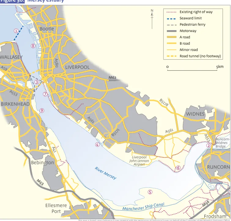
Figure 30: Mersey estuary
Figure 30 shows the Mersey estuary between its seaward limit 1 and the Runcorn-Widnes bridge 2, which is the first upstream bridge and has pedestrian access. The trail may end at either of
these places or Natural England may specify any other point on either bank between them.
Ferry service
There is a frequent, daily pedestrian ferry service between Liverpool and Birkenhead 3. This
could provide a convenient place to cross the river.
Character of the estuary
Nature of the land
The river banks are predominantly developed. There are few typical coastal land forms, but the shoreline is rocky for a short stretch downstream of Garston on the north bank 4 and there are
extensive mudflats along the south bank between Frodsham and Ellesmere Port. Topography of the shoreline
The topography of the shoreline is dominated by the large bend between Liverpool and Runcorn. There is a large headland on the south bank opposite the airport 5 and another on the north
bank opposite Runcorn 6.
River width
The Mersey broadens dramatically downstream of Runcorn, then narrows at Liverpool on its approach to the sea.
Features of interest
There are many features of interest along this stretch, in particular at Liverpool, where the historic docks 7 have special maritime significance.
Recreational benefit
There is potential to provide a designated pedestrian route to the open coast from the city of Liverpool in particular, and from other towns on the affected stretch.
Excepted land
There are several significant areas of excepted land on both banks, including docklands to the north of Liverpool 8 which are not currently accessible to the public, the container port at Garston 4 and the oil terminal at Rock Ferry 9.
WIDNES RUNCORN Frodsham Ellesmere Port Bebington BIRKENHEAD WALLASEY LIVERPOOL Bootle Rive r Mersey M62 M53 Manchester Ship Canal A561 A561 A580 A59 A553 A41 M56 Runcorn-Widnes Bridge Liverpool John Lennon Airport A553 B517 8 B5171 0 5km N
This map is based upon Ordnance Survey material with the permission of Ordnance Survey on behalf of the Controller of Her Majesty’s Stationery Office. © Crown copyright. Unauthorised reproduction infringes Crown copyright and may lead to prosecution or civil proceedings. Natural England 100022021 2009 Existing right of way
Seaward limit Pedestrian ferry Motorway A road B road Minor road
Road tunnel (no footway) Figure 19 2 1 3 4 5 6 7 8 9
Figure 30: Mersey estuary
Options
This brief analysis suggests the following options:
End the trail at the seaward limit. However, there is no means to cross the river at this point. Specify a suitable point near the ferry between Liverpool and Birkenhead. This would provide a
means to cross the Mersey and a pedestrian link from Liverpool to the open coast. It could incorporate nearby features of interest such as the historic docks. However, this option would require a significant inland detour around the docks north of Liverpool.
Align the trail as far as the Runcorn Bridge, where pedestrians can cross the river on foot. This would provide a link to the open coast for more communities and create a potential circular route around the wide stretch of river between Liverpool and Runcorn. However, this option would require significant detours around port and industrial facilities.
Figure 31: Humber estuary
Figure 31 shows the Humber estuary between its seaward limit 1 and the Humber bridge 2 ,
which is the first upstream bridge and has pedestrian access. The trail may end at either of these places or Natural England may specify any other point on either bank between them.
Ferry service
There is no ferry service on this stretch.
Character of the estuary
Nature of the land
There are extensive mudflats throughout the affected stretch, with saltmarsh and lagoons in places. There is also a popular beach at Cleethorpes.
Topography of the shoreline
The river mouth is dominated by the Spurn Peninsula on the north bank and by several distinctive bays on the opposite bank. The upstream banks are uniform for long stretches, although there is a significant bend just downstream of Kingston-upon-Hull.
River width
Overall the river is wide along this stretch in comparison to stretches further upstream. It widens significantly downstream of Grimsby.
Features of interest
There are several features of interest along this stretch, including the Humber Bridge itself and the historic port towns of Kingston-upon-Hull and Grimsby.
Recreational benefit
There is potential to provide a designated pedestrian route to the open coast for several significant communities along this stretch, including the towns of Kingston-upon-Hull, Grimsby and
Cleethorpes. KINGSTON UPON HULL A1033 Bartonupon -Humber Barrow upon Humber Immingham Grimsby Cleethorpes Humberston Patrington Keyingham Thorngumbald Hedon Goxhill River Hum ber B1445 A63 A1105 A165 A1 5 A1077 Humber Bridge Spurn Head A180 A1098 A46 B1206 0 5km N
This map is based upon Ordnance Survey material with the permission of Ordnance Survey on behalf of the Controller of Her Majesty’s Stationery Office. © Crown copyright. Unauthorised reproduction infringes Crown copyright and may lead to prosecution or civil proceedings. Natural England 100022021 2009 Figure 20
National Trail (Yorkshire Wolds Way) Other existing right of way
Seaward limit A road B road Minor road 1 2
Excepted land
There are port and industrial facilities on the banks at Grimsby, Immingham and Kingston-upon-Hull.
Options
This brief analysis suggests these two options:
End the trail at Spurn Head (the seaward limit) on the north bank and Grimsby on the south bank. This would provide a link along the open coast on the south bank for the communities of Grimsby and Cleethorpes and incorporate the bays south-east of Cleethorpes. However, there would be no means to cross the estuary on foot.
Align the trail as far as the Humber Bridge. This would provide a pedestrian route to the open coast from Kingston-upon-Hull and a means to cross the river on foot. However, it would require some detours around port and industrial facilities.
Figure 32: Thames estuary
Figure 32 shows the Thames estuary between its seaward limit 1 and the foot tunnel at
Woolwich107 2. The trail may end at either of these places or Natural England may specify any other point on either bank between them.
Ferry service
A frequent ferry service is available to foot passengers between Gravesend and Tilbury, which runs every day except Sundays and Bank Holidays 3.
Character of the estuary
Nature of the land
There are extensive flats and saltmarsh throughout the affected stretch. There are popular beaches on the north shore at Southend-on-Sea.
Woolwich M25 Barking Dartford Gravesend Rochester Gillingham Sittingbourne Sheerness Southend-on-Sea Canvey Island Tilbury Grays Isle of Sheppey Hoo Peninsula M25 M2 A2 A228 A226 A2 A13 A13 A13 Rive r Thames River Medw ay A249 Dartford tunnel and bridge
This map is based upon Ordnance Survey material with the permission of Ordnance Survey on behalf of the Controller of Her Majesty’s Stationery Office. © Crown copyright. Unauthorised reproduction infringes Crown copyright and may lead to prosecution or civil proceedings. Natural England 100022021 2009 N 0 5km National Trail (Thames Path) Other existing right of way Seaward limit Motorway A road B road Minor road Figure 21 1 2 3 4 5 6 7 8 9 Figure 32: Thames estuary
Topography of the shoreline
The most prominent features are the Isle of Sheppey, the Medway estuary and Hoo Peninsula on the south shore, and Canvey Island on the north shore. The Medway estuary is complex, with several inlets and islands. Upstream of the Hoo Peninsula, there are several distinctive bends in the river and significant tributaries at the Darent 4 and at Barking Creek 5.
River width
The river widens significantly downstream of three points: Gravesend, Canvey Island and Sheerness. Features of interest
There are numerous features of interest along the affected stretch, for example the extensive nature reserves at Cliffe 6, and the historic docks at Rochester.
Recreational benefit
There is potential to provide a designated pedestrian route to the open coast for several significant towns and London suburbs along the affected stretch, including Gravesend, Southend-on-Sea, Rochester and Gillingham.
Excepted land
There are several extensive areas of excepted land along the affected stretch, including port and industrial facilities at Dagenham 7, Tilbury, Coryton 8 and the Isle of Grain 9.
Options
This brief analysis suggests these three options:
End the trail at Canvey Island on the north bank and Rochester on the south bank. This would provide a link to the open coast for several coastal towns and incorporate several significant features including the Isle of Sheppey and part of the Medway estuary. There are relatively few areas of excepted land on this stretch. However, the trail would not cross the Thames.
Align the trail upstream to the Gravesend-Tilbury ferry on both banks. This would provide a link to the open coast for communities living along the affected stretch and a means to cross the river on foot. However, it would require detours around significant port and industrial facilities.
Align the trail as far as the Woolwich foot tunnel. This would provide a pedestrian route to the open coast from Greater London and a means to cross the river on foot. However, it would require significant detours around port and industrial facilities.
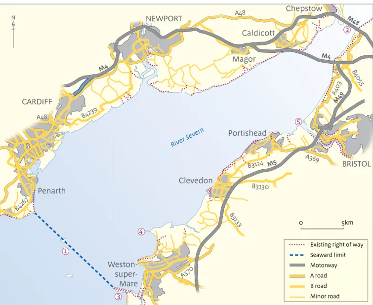
Figure 33: Severn estuary
Figure 33 shows the Severn estuary between its seaward limit at Weston-super-Mare 1 and the
M48 bridge 2, which is the first bridge with pedestrian access. Natural England may specify a limit for the trail at either of these two places or at any point on either bank between them.
Ferry service
There is no ferry service across the Severn estuary.
Character of the estuary
Nature of the land
There are beaches, dunes and cliffs around Weston-super-Mare, more beach at Clevedon and low cliffs between Clevedon and Portishead. There are extensive tracts of mudflat throughout and areas of saltmarsh in places.
Topography of the shoreline
There are prominent headlands at Brean 3 and Sand Point 4 and smaller ones at Clevedon and
Portishead. There are several tributaries, the largest of which is the River Avon at Avonmouth 5.
River width
The Severn is already wide where it reaches the M48 bridge. It widens significantly again downstream of the M4 Bridge, and again at Portishead.
Features of interest
There are many features of interest along the affected stretch, including the Severn bridges; the piers at Weston-super-Mare and Clevedon; and Middle Hope nature reserve 4.
Recreational benefit
There is potential to provide a designated pedestrian route to the open coast and across to the Welsh coast from the towns of Weston-super-Mare, Clevedon and Portishead and the city of Bristol.
Excepted land
There are extensive port and industrial facilities at Avonmouth and Portbury Docks 5. Options
This brief analysis suggests these three options:
End the trail at Sand Point 4. This would provide a route from Weston-super-Mare along the
open coast, and could incorporate beaches, dunes and cliffs in the vicinity of the town. However, there would be no means to cross the Severn to Wales.
Align the trail as far as Portishead. This would incorporate several more beaches and other features of interest. It would provide a route along the English coast for other towns along that stretch, but there would be no means to cross the river to Wales.
Align the trail as far as the M48 bridge. This would provide a pedestrian link to the coast of Wales. However, it would require a significant detour around port and industrial facilities at Avonmouth. M5 M49 M4 M48 M4 NEWPORT A48 CARDIFF BRISTOL Weston- super-Mare Clevedon Portishead Penarth Magor Caldicott Chepstow A48 A403 A369 A370 B3130 B3 133 B3124 B4055 B4239 B426 7 River S evern 0 5km
This map is based upon Ordnance Survey material with the permission of Ordnance Survey on behalf of the Controller of Her Majesty’s Stationery Office. © Crown copyright. Unauthorised reproduction infringes Crown copyright and may lead to prosecution or civil proceedings. Natural England 100022021 2009 N
Figure 22
Existing right of way Seaward limit Motorway A road B road Minor road 1 2 3 4 5 Figure 33: Severn estuary
Figure 34: Parrett estuary (Somerset)
Figure 34 shows the Parrett estuary between its seaward limit 1 and the first bridge at Bridgwater 2, which has pedestrian access. Natural England may specify a limit for the trail at either of these
two places or at any point on either bank between them.
Ferry service
There is no ferry service across this stretch.
Character of the estuary
Nature of the land
There are cliffs at Brean Down 3 and beaches and dunes between Brean and Burnham-on-Sea.
There are extensive mudflats in Bridgwater Bay. Topography of the shoreline
There are prominent headlands at Brean Down and Stert Point. The River Brue empties into the Parrett opposite Stert Point. There are several large bends in the river between Bridgwater and Stert Point. River width
The river widens gradually from Bridgwater to Stert Point. At Stert Point it widens dramatically into Bridgwater Bay, where the estuary has the appearance of open coast.
Features of interest
Brean Down 3 includes a Napoleonic fort and views over the Bristol Channel. There is popular
birdwatching over Bridgwater Bay. Upstream from Stert Point is the historic port of Combwich and the museum and docks at Bridgewater.
Recreational benefit
There are already footpaths on both banks between Bridgwater and Stert Point, though these might be improved by the introduction of coastal access rights, for example by enabling the paths to adapt to erosion. There could be improved public
access for communities between the River Brue and Brean Down, including rights across the beaches and dunes there.
Excepted land
There is a pedestrian route seaward of the power station at Hinckley Point 4. There
appear to be no other significant areas of excepted land on the estuary.
Options
This brief analysis suggests these two options: End the trail at Stert Point on the south
bank and the mouth of the River Brue on the north bank. This would incorporate the widest section of estuary with the
strongest coastal characteristics. It would link the coastal trail to the footpaths extending upstream, but the coastal trail would not itself incorporate those
upstream paths or the bridge they lead to. Align the trail as far as the crossing point at
Bridgwater. This might enable
improvements to the existing footpaths on the river banks and would incorporate
more features of interest. BRIDGWATER
Cannington Puriton Huntspill Dunball Highbridge Burnham-on-Sea Brean Weston-super-Mare Combwich Pawlett M5 A39 A38 A39 B3140 RPa rret t Stert Point BRIDGWATER BAY Huntspill R iver R Brue 0 5km N
This map is based upon Ordnance Survey material with the permission of Ordnance Survey on behalf of the Controller of Her Majesty’s Stationery Office. © Crown copyright. Unauthorised reproduction infringes Crown copyright and may lead to prosecution or civil proceedings. Natural England 100022021 2009 Existing right of way Seaward limit Motorway A road B road Minor road 3 4 2 1
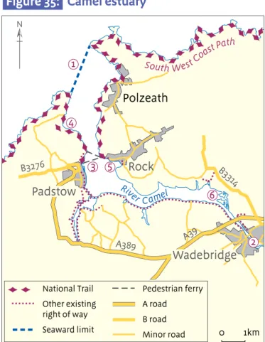
Figure 35: Camel estuary (North Cornwall)
Figure 35 shows the Camel estuary between its seaward limit 1 and the first bridge with
pedestrian access at Wadebridge 2 . Natural England may specify a limit for the trail at either of
these two places or at any point on either bank between them.
Ferry service
There is a ferry service available to foot passengers between Padstow and Rock, which runs every day except Sundays in winter 3.
Character of the estuary
Nature of the land
There are popular beaches at Harbour Cove 4, Porthilly Cove 5 and Polzeath. There are extensive
sandflats all along the estuary at low tide, and a small area of saltmarsh at Trewarnan 6.
Topography of the shoreline
There are distinctive coves, bays, creeks and inlets all along the affected stretch on both banks. River width
The width of the estuary is variable. It widens significantly one mile downstream of Wadebridge and again just upstream of Padstow and Rock. It narrows again briefly downstream of Padstow, before widening again – dramatically so at Polzeath.
Features of interest
There are viewpoints from the hills north of Rock and Padstow. Both Padstow harbour and the waterfront at Rock attract tourists. There is birdwatching along both river banks.
Recreational benefit
The south/west bank of the estuary is already well-served by public rights of way. There is potential for a new link on the north/east bank from Wadebridge to the sea. There could also be improved access rights for affected
communities along the estuary, in particular to potential spreading room.
Excepted land
There appear to be no significant areas of excepted land on the estuary.
Options
This brief analysis suggests these two options: End the trail at Padstow on the west bank
and Porthilly Cove 5 on the east bank,
incorporating beaches at Polzeath, Harbour Cove and Porthilly 5. The public would
cross the river by ferry between Padstow and Rock.
End the trail at Wadebridge. This would create a new link on the north/east bank from Wadebridge to the sea, and make a circular route between the ferry and the bridge. Rock Padstow Wadebridge Polzeath A389 A39 B3314 B3276 South WestCo astPath River Camel National Trail Other existing right of way Seaward limit Pedestrian ferry A road B road Minor road
This map is based upon Ordnance Survey material with the permission of Ordnance Survey on behalf of the Controller of Her Majesty’s Stationery Office. © Crown copyright. Unauthorised reproduction infringes Crown copyright and may lead to prosecution or civil proceedings. Natural England 100022021 2009 N Figure 24 0 1km 1 2 3 4 5 6 Figure 35: Camel estuary
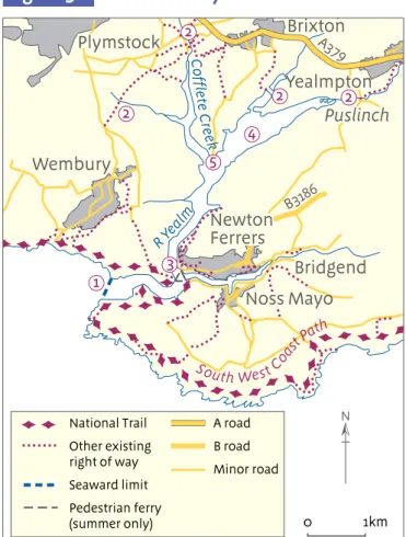
Figure 36: Yealm estuary (South Devon)
Figure 36 shows the Yealm estuary, including its seaward limit 1 and various bridging points on its
tributaries upstream 2. Natural England may specify a limit for the trail at any of these points or at
any point on either bank between them.
Ferry service
There is a pedestrian ferry service which crosses the river from two places on the east bank at Newton Ferrers during the summer months 3.
Character of the estuary
Nature of the land
There are cliffs on both banks between Newton Ferrers and the open sea. There are extensive mudflats in the wider reaches upstream 4.
Topography of the shoreline
The topography of the shoreline is varied and interesting. There is a junction at Newton Ferrers. The main channel continues northwards past small creeks before dividing again at Steer Point 5.
Both channels then divide further before reaching the pedestrian crossing points. River width
The river narrows just upstream of the seaward limit, but widens again significantly northeast of Steer Point 5.
Features of interest
There are viewpoints on either bank downstream of Newton Ferrers. There are causeways across some creeks upstream of Newton Ferrers which can be crossed at low tide.
Recreational benefit
There is considerable potential to improve public access upstream from Newton Ferrers, including pedestrian routes to the coast from
Brixton, Puslinch and Yealmpton. A more modest improvement could be achieved by providing a secure pedestrian route from Noss Mayo to the ferry point.
Excepted land
There are parks and gardens on the shoreline in some places.
Options
This brief analysis suggests these two options: End the trail at the ferry point on the west
bank and at Noss Creek on the east bank. This would create a better pedestrian link from Noss Mayo to the ferry point. However, there would be no means to cross the
estuary on foot during months when the ferry does not operate.
Create a continuous route around the estuary, incorporating the existing bridges across the various inlets and tributaries. Detours may be necessary around private gardens, where these extend to the river bank.
Figure 36: Yealm estuary
B3186 A379 Newton Ferrers Wembury Noss Mayo Plymstock Brixton Yealmpton R Yea lm C of fle te C re ek Bridgend Puslinch South West Coa stPat h
This map is based upon Ordnance Survey material with the permission of Ordnance Survey on behalf of the Controller of Her Majesty’s Stationery Office. © Crown copyright. Unauthorised reproduction infringes Crown copyright and may lead to prosecution or civil proceedings. Natural England 100022021 2009 N National Trail Other existing right of way Seaward limit Pedestrian ferry (summer only) A road B road Minor road Figure 25 0 1km 2 2 2 4 5 2 1 3
© Natur