Keeping It
Green
A Study of Open Space Conservation Efforts in the Triangle
Katherine Hebert
Department of City and Regional Planning
University of North Carolina, Chapel Hill
Advisor, Dr. Todd BenDor
2
Foreword
“Make no little plans. They have no magic to stir men’s blood and probably themselves will not be realized. Make big plans. Aim high in hope and work. Remembering that a noble, logical
diagram once recorded will not die.”
This inspirational quote for Daniel H. Burnham, the city planner who designed Chicago in the early 1900s, guided the early scope of this study and should continue to guide the study’s participants as they persevere in their efforts to conserve open space in the Triangle Region. Although at times Robert Burn’s quote “the best laid plans of mice and men often go astray” seems more fitting (both for the report and for open space preservation), it is important to
remember why we do what we do. Whether it is a desire to protect the natural areas that we love, the farmland that we depend on, or the water that is critical for our survival, we are united in our goal to preserve our heritage, while providing for current and future generations. So we keep on going despite tough economic times, relentless development pressure, and surmounting
environmental challenges by developing partnerships and innovative ways to solve age-old problems. Knowing that we can’t save it all but we should save what we can.
The following report could not have been completed without the assistance of many busy and passionate people who contributed their time and expertise. A special thanks to all the study participants, GIS technicians, and data providers. The staff and board members of the Triangle Land Conservancy- especially George Hess, Leigh Ann Cienek, and Kevin Brice- who helped guide the process along and provided valuable feedback. Thanks to Paul Black with the Triangle J Council of Governments, who assisted with data collection and organization. Also to the librarians at the University of North Carolina, Chapel Hill - especially Jennifer Doty and
Amanda Henley- I simply could not have created these maps without your help. Finally, I would like to thank my advisor Dr. Todd BenDor for pointing me in the right direction to this journey’s trailhead and having the patience to wait for me as I wandered through the woods.
3
Acknowledgements
Study Participants
Triangle Land Conservancy Staff and Board Members
Kevin Brice
Alberto Alzamora
Dan Bruer
Cheryl Chamblee
Ellica Church
Leigh Ann Cienek
Robert Howes Adam Abram Tandy Jones Jeff Masten Aime Mitchell Doug Nicholas Jennifer Peterson Jessica Poland Tabitha Roberson John Scott Walt Tysinger George Hess Charlie Bolton Stacey Burkert Lanier Cansler Rodney Gaddy Bill Holman Sig Hutchinson Danny Kadis William London Chuck Neely Virginia Parker
Joan Siefert Rose
Dale Threatt-Taylor
Larry Tombaugh
Kevin Trapani
Anne Stoddard
Ron Strom
Laura Horton Virkler
Larry Zucchino
Robert L. Bridwell, (AICP) Director
Planning and Development Lee County
Tracy M. Burnett Department Director Parks and Recreation Department
Chatham County
Jane Korest Administrator
Open Space & Real Estate Division Durham
Greg Schuster Open Space Land Manager Open Space & Real Estate Division
Durham County
Wendy D. Seddon
Open Space & Real Estate Coordinator Open Space & Real Estate Division
Durham County
Rich Shaw
Land Conservation Manager
Environment and Resource Conservation Department Orange County Kevin Sigmon Planner Planning Department Johnston County Chris Snow Director
Parks, Recreation, & Open Space Wake County
Helen Youngblood Senior Planner
City-County Planning Department Durham County
Helen Youngblood Senior Planner
4
Table of Contents
Executive Summary
Introduction
Overview of the Triangle ………...7-9 What is Open Space………...10 Why do we need Open Space………...11-12 The North Carolina Million Acre Initiative………. .12 Who is working on Open Space Preservation………....13 How can we Preserve Open Space………14-16 Challenges to Open Space Preservation ………...16 Report’s Goals and Methods ………17-19
Land Conservation Efforts
Overview of Conservation Efforts………... 20-23 State Funding Trends………....24-28 Regional Open Space Planning Efforts……….29-30 Regional Open Space Resources ………..31-33 Triangle Land Conservancy Lands ………34 County-by-County Assessment… ……….35
Wake County………36-38
Durham County...………...………..39-41
Orange County………..42-44
Chatham County………...45-47
Lee County……….. 48-50
Johnston County………...51-53
Recommendations
Next Steps……….54-55
Appendixes
5
Executive Summary
This is the first report of its kind in the Triangle Region defined as Wake, Durham, Orange, Chatham, Lee, and Johnston counties in central North Carolina. Although there have been regional open space planning efforts in the past- most markedly the GreenPrint of 2002 and the
State of Open Space Reports in 2000 and 2002- this is the first report that combines GIS
mapping and analysis with interviews of key stakeholders and a review of plans relevant to open space protection. Thanks to advancements in mapping software and the management of parcel information and land acquisition by each county within the region, a more accurate and comprehensive map of conservation lands is now possible. The availability and accuracy of maps displaying the latest information on conservation lands and easements will play a critical role in the region’s ability to conduct open space planning on regional projects.
The major finding of this report is that the calculated acreage of conserved lands according to GIS analysis is greatly below the acreage of conserved lands being reported by the different municipalities, non-profit organizations, and federal or state agencies. When the conservation lands and conservation easement shapefiles of the One NC Naturally planning tool were merged, clipped by county boundaries, and dissolved to form one layer with no duplicated properties, the total acreage of land conserved within the Triangle as of July 2009 was 155,499 acres. This is actually about 200 acres less than what was reported in the 2002 State of Open Space Report
(Costa, 2002). If progress has been made in land conservation within the Triangle how is this possible?
There are a couple of explanations for these findings. In some cases, especially with the larger management areas such as those surrounding Jordan Lake or Falls Lake, the same property had multiple property owners each reporting part or all of the property. While this is a good indicator that regional partnerships are occurring, it also leads to an overestimation of the actual land that is being protected through conservation measures such as fee simple purchase or conservation easements. Another possible explanation is the definition of what is being considered open space is different from one report to the next. For example, the 2002 State of Open Space Report
includes corporate lands while the category of corporate lands was not included within the One NC Naturally database (Costa, 2002).
6
properties strictly within county boundaries (see the section on an Overview of Conservation Efforts for these tables).
The findings of this report- both through the interviews and GIS analysis components- bring to light some important questions and data needs for further analysis:
1. What is Open Space and is it possible or wise to have a regionally accepted definition? 2. How is the region doing in its conservation efforts and how is this progress measured? 3. Can an inclusive yet user friendly database be developed to accurately track the progress
of conservation efforts?
4. What are the challenges and assets to open space preservation and how can the region
increase its conservation efforts? and
5. What are the next steps in regional conservation planning?
7
Introduction
Overview of the Triangle
The Research Triangle, as the region encompassing Raleigh, Durham, and Chapel Hill has been commonly referred to since the 1950s, offers its residents a superb quality of life. With the vast number of graduates from the University of North Carolina Chapel Hill, North Carolina State University, and Duke University staying in the region and taking positions in medical research, science, and technology available at the Research Triangle Park, the region is considered one of the most educated in the nation. This high level of education and job availability, along with the outstanding entertainment and recreational opportunities found within the Triangle make the region a great place to live.
Figure 1 Map of the Triangle Region
Map by: Katherine Hebert
8
equivalent of 40 people moving in each day for eight years. This population growth requires increased housing development.
The table below shows the number of building permits reported for each major municipality and the unincorporated areas within the Triangle’s six counties from January 1997 to 2010. A total of 169,287 building permits were issued with the majority of these being for single family houses. Assuming a typical density of two dwelling units per acre (although low density housing patterns consist of anything between one unit per multiple acres to four units per acre), the 217,191
dwelling units constructed during these 13 years have consumed close to 108,600 acres of land. To put that in perspective, the total area of Durham County is 191,100 acres.
Table 1 Total Building Permits in the Triangle from January 1997-2010
Source: US Census Bureau, 2010
Buildings Units Construction Costs (in Billions $)
Chatham County 6,638 7,128 1.56
Durham 21,993 33,749 4.02
Johnston 16,577 16,868 2.15
Lee 3,603 4,235 0.49
Orange 10,764 12,538 2.03
9
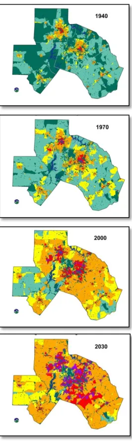
The maps to the left show the housing density within the Triangle region, measured as housing units per square kilometer (Ingerson, 2007). Housing units include both year-round primary residences and
seasonal homes. The maps do not show conserved lands within the housing density blocks, because researchers do not know the exact position of houses and therefore must color the entire census block as one color to represent the overall density level.
As shown by the table of building permits and these maps, the pace of growth has been rapid within the Triangle. This growth has placed a severe strain on the region’s resources including its undeveloped land, pristine natural areas, water bodies, and operating farmlands and forests (Costa, 2002). In order to control this rapid growth and preserve the quality of life attracting businesses and families to this region in the first place, a concerted effort to plan for, acquire, and provide stewardship for open space is needed (Costa, 2002).
Source: Ingerson,2007
10
What is Open Space?
Open Space has been simply defined as “land left as fields and forests while other land is developed into homes and
businesses” (Ahern, 1991). This is an oversimplified definition that continues to be debated among planners, recreation specialists, and conservationists. Participants in this study were asked how their organization or local government defines open space and each provided a slightly different answer. The questions of should the region have an agreed
upon definition of what is considered open space and how to prioritize lands for conservation efforts would provide for an interesting discussion among conservation planners.
For the purposes of this report, open space will be defined according to the Triangle Land Conservancy’s definition. TLC (Costa, 2002) defines protected open space as land:
1. That is being managed primarily to fulfill an open space function (wildlife habitat, water quality protection, flood prevention, agriculture, forestry, recreation, sense of place, education, research, or air quality improvement), and
2. That is owned or managed by a public agency or non-profit organization whose mission,
at least in part, is to conserve and/or manage open space for public benefit (but not necessarily public access), and
3. For which the owner
a. Has either made a long-term, public commitment to using that land for that
purpose or
b. Would have to go through a public process to change its use.
“We don’t have a set definition…it depends greatly on who is the audience and what we are trying to accomplish.”
11
Open Space Functions
Wildlife and Native Plant Habitat- Open space provides habitat for native plants and animals that cannot live in urban and
suburban environments. Some species depend on large wooded tracts for their survival, while others need grassy areas
for habitat.
Water Quality Protection and Flood Prevention- Wetlands, vegetated stream
buffers, and natural floodplains filter urban stormwater run-off, reducing the
amount of pollutants entering streams, and retaining floodwaters.
Agriculture and Forestry- Agriculture and forestry cannot remain financially viable without large open spaces in which
they can be practiced. These landscapes are also an important part of the region’s
cultural heritage.
Recreation- Hiking, biking, horseback riding, hunting, fishing, camping, and bird watching, are recreational activities
that require extensive open spaces and natural areas.
Sense of Place- Open space is a component of many of the things that help define our region’s character, like farmland, historic sites, and scenic vistas.
Education- We use open spaces in the Triangle as both classrooms and research
laboratories for ecological, agricultural, and forestry studies.
Air Quality Improvement- Vegetation in open spaces absorbs carbon dioxide and other pollutants from the atmosphere and
provides shade, reducing air pollution levels and cooling the air.
Why do we need Open Space?
There are many environmental, economic, and social benefits of preserving open space. Environmental benefits to open space conservation include: providing habitat for healthy populations of plants and animals to preserve biological diversity; protecting critical bodies of water including coastal areas, wetlands, and rivers; purifying the air, water, and soil; and providing climate controls (Mason, 2008). Each of these benefits is important to the well-being of the human
population as well as the overall stability of the planet’s ecosystems. Since the early 1990s the holistic ecosystem management model has taken root within the policies and partnerships of federal, state and regional departments as it has become increasingly obvious that protecting small or isolated islands of habitat is not enough to maintain the systems needed to reap these benefits (Mason, 2008 and Endicott, 1993).
Will Rogers, President of the Trust for Public Lands, summarizes the character of land preservation in economic terms quite well- “open space conservation is not an expense but an investment that produces important economic benefit” (Lerner, 1999). Open space protection can reduce the
likelihood of sprawl development that consumes more land than high density development, requires more infrastructure, increases daily commutes, lowers real estate values, and reduces quality of life (Lerner, 1999). In addition to reducing the negative impacts of sprawl, open space protection can generate economic activities such as recreational tourism, attracting new businesses, farming, and forestry (Lerner, 1999). The natural systems protected by land preservation also serve important economic services such as flood and climate change reduction, pollination, filtration of pollutants, decomposition, soil and water conservation, and the provision of building materials, medicines, pigments, and spices (Lerner, 1999). Because open space provides so many services
12
The social benefits of preserving open space include: providing ways for people to connect with nature by enjoying scenic vistas or participating in recreation, education, and research; sustaining a natural heritage; and developing a sense of place (Triangle GreenPrint, 2002). Open space conservation is also an important part of American history culminating in the formation of national parks and wildlife refuges since Yellowstone in 1872. In his foreword to a book describing the need for private/ public partnerships in land conservation efforts, former U.S. Senator John H. Chafee began with this statement: “Open, undeveloped land and the freedom and possibilities it represents has always been an important part of the American
identity”(Endicott, 1992).
The North Carolina Million Acre Initiative
Organized by the North Carolina Department of Environment and Natural Resources (DENR), the goal of the Million Acre Initiative is to preserve one million additional acres of open space in North Carolina between 1999 and 2009. This is a coordinated effort among many federal, state, local, and nonprofit agencies to fund and acquire open space with the objectives of:
Fostering partnerships among private and public land protection partners,
Promoting regional open space planning, and
Providing information about the importance of open space protection. (NC Million Acre
Initiative, 2009).
If the one million acres was evenly divided across the state by land area, then the Triangle would be responsible for protecting 63,000 acres (Costa, 2002). However, if the million acres were attributed to counties based on population, the Triangle would be responsible for 150,000 acres. As of 2009, the Triangle has protected a total of 155,499 acres which is only 9,431 more acres than what was recorded in the 2000 State of Open Space Report. This is 15% of the rate needed to preserve 63,000 acres and 6.3% of the rate needed to preserve 150,000 acres.
The Triangle’s progress is representative of the state’s progress as a whole. As of the 2007 Annual Report for the Million Acre Initiative Goal, a total of 589,685 acres had been conserved across North Carolina (NC Million Annual Report, 2007). While this is still a commendable feat, this is far short of the one million acre goal. It is safe to say that with the national economic decline of the last two years this goal is not likely to be met; however, some very useful regional conservation planning tools have come out of this initiative including additions to the One NC Naturally database used to map conservation lands and easements throughout the state. It is also interesting to note that the Triangle region is highlighted prominently on the Million Acre
Initiative’s website with Wake County’s Open Space Partnership Grant Program, the Town of
Cary’s Open Space and Historic Resources Plan, and Orange County’s Environment and
13
Who is working on Open Space Preservation?
There is a wide variety of partners- state and federal agencies, counties, local municipalities, non-profits, universities, and private organizations- contributing to open space conservation in the Triangle. The following list was taken from previous State of Open Space reports.
State and Federal Agencies
NC Department of Cultural Resources NC Department of Transportation NC Division of Forest Resources
NC Division of Natural Resources Planning and Conservation
NC Division of Parks and Recreation NC Office of Conservation and Community Affairs
U.S. Army Corps of Engineers U.S. Fish and Wildlife Service Wildlife Resources Commission
Non-Profits
American Farmland Trust Conservation Council of NC
Conservation Trust for North Carolina Ellerbe Creek Watershed Association Eno River Association
NC Audubon Society NC Botanical Foundation NC Herpetological Society NC Rails to Trails
People for Parks
Triangle Greenways Council Triangle Land Conservancy Trust for Public Land
Upper Neuse River Basin Association
Universities
Duke University
Johnston Community College NC State University
UNC Chapel Hill Private Organizations
Homeowner Associations Landowners
Orange Water & Sewer Authority Progress Energy
RDU Airport Authority
14
How can we Preserve Open Space?
There are many measures that the different partners can take to increase the amount of land being preserved or better protected within the Triangle. The two most common measures of protection include fee simple purchase of property and the installation of perpetual conservation easements on all or a portion of property. Many factors, including available funding, the quality and purpose of the land, and willingness of
landowners to limit future development or sell, will determine which properties are conserved and what tool is used to protect either all or a portion of a property. An extensive list of
measures that different types of organizations can use were suggested by study participants and other resources and can be
found below. Some of these recommendations are widely accepted and extensively used in North Carolina while others are more innovative and less frequently used.
Private Landowners, Businesses, and Non-profits
Measures private landowners can take to conserve land include:
Donating their land outright, by will, or through a trust to an interested land conservancy organization or government entity (Roe, 1985).
Permanently limiting the use of their land by voluntarily granting a conservation easement on their property.
In the case of farmers, participating in the Conservation Reserve Enhancement Program,
the Conservation Reserve Program, Farmable Wetlands Program, or the Source Water Protection Program of the USDA Farm Service Agency (USDA FSA, 2009).
For those with forests, participating in the Forest Legacy Program and working with state
foresters to develop a multiple resources management plan.
Property owners next to bodies of water should maintain a vegetated buffer along the
water to limit shoreline erosion, prevent polluted runoff, and provide wildlife corridors along waterways.
Landowners constructing homes should also pay attention to the size, location,
orientation, and ecological footprint of the building. Consider using sustainable building supplies, water-efficient landscaping, energy-efficient appliances, insulation, and solar panels.
Measures businesses can take to conserve land include:
Participating in conservation investment banking- often in partnership with banks, land
conservancy organizations, and local governments- to: swap debt for nature conservation, “The number one asset to increased open space conservation is a growing awareness among the general public that communities must act now (or in the short-term) if they want a town or county that is livable well into the future.”
15
lend money linked to conservation, receive public recognition for environmentally and socially responsible investing, and avoid bankruptcy/ defaulting through the sale of land (Ginn, 2005).
Developing new markets for environmental services such as: carbon sequestration, water
rights and markets, forest bans, and wetland mitigation banking (Ginn, 2005).
Taking advantage of incentives such as: green consumer programs, tax credits, Federal
incentives, and the LEED certification program (Ginn, 2005).
Measures non-profits and land trusts can take to conserve land include:
Assist government entities at the local, state or federal level with land conservation programs through:
o Providing agility- mainly in the speedy acquisition of land, flexibility in land deals such as auctions, and creativity to develop financing arrangements that suit the needs of both property owners and conservation organizations.
o Creating an atmosphere of possibility- landowners prefer to work with land trusts
as a third party instead of governments which have the power to condemn land. Land trusts provide landowners and the public with important information on how their land can be preserved and the need for conservation. People are also more willing to donate funds to nonprofit organizations than government entities even when serving the same purpose.
o Providing volunteers, trained staff, and experts to assist with open space planning, land evaluation, land management, and research (Endicott, 1993).
Local Governments, Regional Governments, and State Agencies
Measures Local Governments can take to conserve land include:
Promote and conduct planning efforts such as: creating open space, greenway, and
recreation plans; considering growth management tools such as urban growth boundaries, transfer of development rights, clustered neighborhoods, mixed use zoning, and impact fees; and promoting transit-oriented design.
Other measures local governments could take include: proposing a sales tax referendums
to preserve open space; organizing educational and community goal setting programs; purchasing and managing land for parks; and developing regional partnerships.
Measures regional governments or partnerships can take to conserve land include:
Conducting regional planning efforts to identify key areas to conserve and providing
municipalities with information.
Providing coordination and communication between municipalities on joint projects or
16 Measures state governments can take to conserve land include:
Increasing fundraising initiatives including: a state lottery; minimal entrance fees to state parks, increased license fees for fishing and hunting; state bond referendums; and
increased taxes on cigarettes, gasoline, or alcohol (Endicott, 1993).
Require local planning and provide smaller localities with financial and expert assistance needed to develop open space and recreational plans. Continue to tie the necessity of being part of a local or regional plan to project funding.
Pass legislation to support localities in their efforts to implement growth management
tools. Launch a state-wide smart growth initiative.
Increase state funding for state departments working on land conservation issues such as
the Department of Agriculture, Department of Forestry, and Department of Environmental and Natural Resources.
Continue to support initiatives that provide statewide planning and information such as
the One NC Naturally program and the Million Acre Initiative.
Challenges to Open Space Preservation
The number one challenge to open space preservation identified by study participants is the lack of funding for land acquisition, maintenance, programs, and staff. State funding for its open space trust funds (Clean Water Management, Natural Heritage, Parks and Recreation, and Farmland Preservation) have all been drastically reduced due to state funding cuts. In February 2009, $100 million was transferred from the Clean Water Management Fund into the state’s General Fund to help cover budget shortfalls, placing many grants on hold (Clean Water, 2008). The Natural Heritage Trust Fund also experienced an overall decrease of 24% from the previous year’s income in 2008 (Natural Heritage, 2008).1
A brief overview of funding sources for open space acquisition is provided later in the report within the section on regional conservation efforts.
Other challenges to open space preservation identified by study participants include: concern over the unknown costs to maintain lands in the long-term, the pace of urbanization, and the ability for citizens and elected officials to visualize the changes that will happen to the balance of open space and development at the regional level and over a long period of time (especially in rural areas).
1
17
Goals and Methods of this Report
The overarching goal of this report is to provide those working on conservation efforts within the Triangle Region with all the tools and information they need to increase their conservation efforts within one report. The report is intended to be used as a resource and a dialogue starter. While speaking with study participants it was interesting to discover that many of them were looking forward to comparing what was happening in their county to the conservation efforts in other counties. I hope this comparison includes a series of discussions between study participants about natural areas of mutual interest, potential partnerships, and innovative techniques for open space planning and land acquisition.
Other goals include:
Updating and improving upon existing reports including the State of Open Space reports
prepared by the Triangle Land Conservancy.
Developing a geo-database of files that could be used to develop additional maps and
combine files across common fields.
Identifying the challenges, facilitators, benefits, funding sources, and measures to increase conservation efforts.
Sharing the results of this study with study participants, decision makers, and the public.
Methodology
A three-pronged approach was taken to accomplish these goals- interviews, mapping, and an in- depth literature review and plan analysis.
Interviews
I conducted a series of interviews with county stakeholders (see Appendix: V). Each interview lasted about half an hour as participants were asked a list of questions concerning their
background and the planning, funding, mapping, and organizational structure of their county in regards to open space conservation (see Appendix: IV). These interviews were used to collect additional data on available open space plans within the county, available GIS data, and the amount of funds spent on open space acquisition by each county. Perhaps the most interesting responses were to the questions included under the heading of organizational questions. Many of these answers were used to construct the sections of the report on the definition of open space, the challenges of open space preservation, and the next steps in regional conservation.
GIS Mapping and Analysis
18
the conserved acreage. The following process was used to create the maps found within the Land Conservation Efforts section of this report.
The Regional Conservation Lands map and the County by County Open Space maps were created using GIS files from the Conservation Planning Tool for North Carolina: Open Space and Conservation Lands database found at http://www.conservision-nc.net/. Two files,
conland0709 and easements0709, were merged to create a single shapefile containing all of the conservation easements and conserved lands within North Carolina. The file was then clipped to contain just the conserved lands and easements found within the Triangle Region of Wake, Orange, Durham, Lee, Johnson and Chatham counties (this shapefile was created earlier by selecting these counties from a shapefile containing all of North Carolina’s Counties). A field was added to the merged conservation lands and easements file to display the county name and a spatial join was used to fill this field.
The attribute table was then sorted by the Type field and the listed owner types were condensed to match the categories found within the 2002 State of Open Space report including federal, state, local (county, municipal, other public, and local), nonprofit (land trust, conservation group, and other nonprofit), or university (reassigned Duke Forest and Schenck Forest to university). The regional map was created using this file, a file of North Carolina counties, and a file of the major North Carolina roads (reduced to U.S. highways and interstates and clipped to the Triangle Region). Colors were assigned accordingly:
o Federal- Tuscan Red
o State- Ultra Blue
o Local- Macaw Green
o Non-Profit- Electron Gold
o University-Aster Purple
o TLC Region- Yucca Yellow
o Other Counties- Gray10%
o Roads- Gray 60%
For each of the county maps, the conservation lands/easements file and major roads file were then furthered clipped to the county’s boundary. If the county had any additional files such as the location of its parks or additional conservation lands then they were added to the map of that county but not added to the calculation of conserved acres.
For the Triangle Lands Conservancy Projects map, shapefiles provided by the Triangle Land Conservancy were simply placed on top of the TLC region shapefile created for the Regional Conservation Lands map.
19
conserved lands and conservation easements by county were also prepared and included within the geodatabase.
In addition to creating maps, ArcGIS was used to calculate the acreage of conserved lands within each county. The process used to do this was to take each county map and dissolve the conserved lands and easement features to remove any duplicates. Then a field was added to the dissolved attribute table and the geometry calculated for area in acres. This calculated the acreage of conserved lands within the boundaries of the county. Note that this is a different methodology from that used within the 2002 Open Space Report where participants were asked for the acreage conserved. Once the county acreage was calculated then a sum could be taken to determine the total acres conserved within the Triangle.
Literature Review and Plan Analysis
Additional research was done to provide background information for this report, suggest
20
Land Conservation Efforts
Overview of Conservation Efforts
According to the GIS analysis discussed in the section on methodology, as of July 2009, 155,499 acres of land have been protected through conservation easements or fee simple
purchase in the Triangle. This represents 7.3% of the Region’s total area and a per capita rate of 0.1 acres per person2. Since the last State of Open Space Report in 2002, approximately $110
millionhas been spent on land acquisition by Wake, Orange, Durham, Lee, Johnston, and
Chatham counties (through tax revenue, grants, bond referendums, donations, etc.). The Triangle Land Conservancy reports another $48 million in land value being conserved since 2002 (Leigh Ann Cienek, 2010).
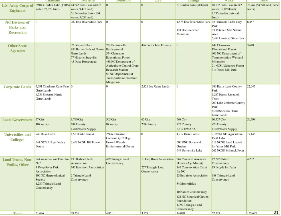
Table 2 shows the protected open space through June 30, 2002 by county and owner type from the last State of Open Space Report (Costa, 2002). This table was produced from information collected from surveys completed by the counties, major municipalities, non-profits, universities, as well as the state and federal agencies with conservation lands within the region. It is important to note that this methodology differs greatly from the methodology used to calculate the acreage of lands conserved within this report, thus making an accurate comparison from 2002 to 2009 difficult.
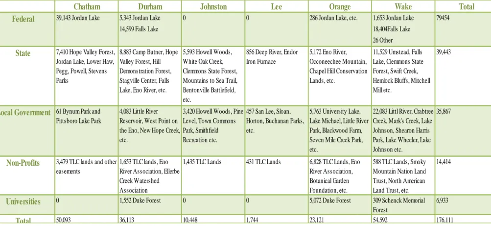
In order to create a more comparable chart, a table with conserved lands and easements as of July 2009 was created with acreage being calculated by owner type prior to the data being dissolved into the separate counties (see Table3). There may be cases where the same acreage has been counted multiple times across owner categories or between multiple counties. Because of these possible duplications, the acreage calculated using the previously mentioned GIS analysis was used for the total acres listed at the beginning of this section.
2
21
Chatham Durham Johnston Lee Orange Wake Total
14,242 Falls Lake (4,827 water, 9,415 land)
18,532 Falls Lake (6,512 water, 12,020 land) 5,154 Jordan Lake (124
water, 5,030 land)
1,715 Jordan Lake (all land)
1,878 Eno River State Park 92 Hemlock Bluffs Cary Park
124 Occoneechee Mountain
93 Mitchell Mill Natural Area
5,481 Umstead State Park
37 Bennett Place 850 Butner Falls of Neuse
231 Bentonville Battleground Game Lands
77 Historic Stagville
354 Clemmons Educational Forest 45 Duke Homestead 488 NC Department of
Agriculture Central Crops Research Station 50 NC Department of Transportation Wetland Mitigation
3,091 Chatham/ Cape Fear Game Lands
680 Harris Lake County Park
6,736 Shearon Harris Game Lands
1,267 Harris Research Tract
200 Lake Crabtree County Park
8,250 Shearon Harris Game Lands
37 City 1,760 City 303 City 65 City 568 City 10,527 City
40 County 634 County 0 County 208 County 772 County 470 County
1,498 Water Supply 2,817 OWASA 1,100 Water Supply
940 Duke Forest 1,553 Duke Forest 4,917 Duke Forest 2,329 NCSU Agriculture Field Labs
341 NCSU Hope Valley Forest
2,451 NCSU Hill Forest 600 UNC Botanical
Garden
212 NCSU Land Leased for Yates Mill Park 544 University Lake 262 NCSU Schenck Forest
34 Conservation Trust for N.C.
13 Ellerbee Creek Association
1 Deep River Association 267 Classical American Homes (Ayr Mount)
12 NC Nature Conservancy 4 Deep River Park
Association
146 Eno river Association 257 Triangle Land Conservancy
143 Conservation Trust for NC
19 People for Parks
100 NC Herpetological Society
2 Triangle Land Conservancy
23 Eno river Association 188 Triangle Land Conservancy 1,280 Triangle Land
Conservancy
84 Moorefields
10 Nature Conservancy 121 NC Botanical Garden Foundation
1,099 Triangle Land Conservancy
Total 51,646 29,251 4,851 3,378 14,048 52,519 155,693
8,457
U.S. Army Corps of Engineers
39,043 Jordan Lake (13,064 water, 25,979 land)
0 0 81 Jordan Lake (all land) 78,767 (54,240 land, 24,527 water)
NC Division of Parks and Recreation
0 789 Eno River State Park 0 0
22,645
Other State Agencies
0 426 Endor Iron Furnace 0 149 Clemmons
Educational Forest 606 NC Department of Transportation Wetland Mitigation 21 NCSU Schenck Forest 314 Yates Mill Park
3,648
Corporate Lands 0 0 2,421 Lee Game Lands 0
Local Government 20,799
Universities and Colleges 2,996 Johnston Community College Howell Woods Environmental Center 0 17,145
Land Trusts, Non-Profits, Other
429 Triangle Land Conservancy
4,232
Table 2 Protected Open Space through June 30, 2002 in Acres by County and Owner Type
22
Chatham Durham Johnston Lee Orange Wake Total
5,343 Jordan Lake 1,653 Jordan Lake
14,599 Falls Lake 18,404Falls Lake
26 Other
5,172 Eno River, Occoneechee Mountain, Chapel Hill Conservation Lands, etc.
11,529 Umstead, Falls Lake, Clemmons State Forest, Swift Creek, Hemlock Bluffs, Mitchell Mill etc.
Local Government 61 Bynum Park and
Pittsboro Lake Park
4,083 Little River Reservoir, West Point on the Eno, New Hope Creek, etc.
3,420 Howell Woods, Pine Level, Town Commons Park, Smithfield Recreation etc.
457 San Lee, Sloan, Horton, Buchanan Parks, etc.
5,763 University Lake, Lake Michael, Little River Park, Blackwood Farm, Seven Mile Creek Park, etc.
22,083 Littl River, Crabtree Creek, Mark's Creek, Lake Johnson, Shearon Harris Park, Lake Wheeler, Lake Johnson etc.
35,867
Non-Profits 3,479 TLC lands and other
easements
1,653 TLC lands, Eno River Association, Ellerbe Creek Watershed Association
1,435 TLC Lands 431 TLC Lands 6,828 TLC Lands, Eno River Association, Botanical Garden Foundation, etc.
588 TLC Lands, Smoky Mountain Nation Land Trust, North American Land Trust, etc.
14,414
Universities 0 1,552 Duke Forest 0 0 5,072 Duke Forest 309 Schenck Memorial
Forest
6,933
Total 50,093 36,113 10,448 1,744 23,121 54,592 176,111
State 7,410 Hope Valley Forest,
Jordan Lake, Lower Haw, Pegg, Powell, Stevens Parks
8,883 Camp Butner, Hope Valley Forest, Hill Demonstration Forest, Stagville Center, Falls Lake, Eno River, etc.
5,593 Howell Woods, White Oak Creek, Clemmons State Forest, Mountains to Sea Trail, Bentonville Battlefield, etc.
856 Deep River, Endor Iron Furnace
39,443
Federal 39,143 Jordan Lake 0 0 286 Jordan Lake, etc. 79454
Table 3 Protected Open Space Through July 30, 2009 in Acres by County and Owner Type
23
F
igu
re
3
T
rian
gle
Re
gio
n’
s Cons
er
va
tion
L
an
ds
Map
b
y
: Kat
he
ri
n
e
H
e
b
e
24
State Funding for Conservation in the Triangle Region
The following is an overview of the major state funding sources for land acquisition, farmland preservation, and clean water management including the Clean Water Management Trust Fund, Natural Heritage Trust Fund, Farmland Preservation Trust Fund, Parks and Recreation Trust Fund, Conservation Tax Credit Program, and Ecosystem Enhancement Program.
Clean Water Management Trust Fund (CWMTF)
Established in 1996, the goal of the Clean Water Management Trust Fund is to combat water pollution. Funding for CWMTF is provided by 6.5% of the unreserved credit balance in the NC general fund at the end of each fiscal year, with a minimum amount of $30 million being
contributed every year (Trust for Public Lands, 2010). Grants are awarded to local governments, state agencies, and conservation non-profits twice a year to clean up polluted water, protect unpolluted water, or acquire land or easements.
As of 2008, CWMTF has invested more than $506.3 million in land and water conservation efforts to preserve over 454,944 acres of land including 4,859 miles of riparian buffers within North Carolina (Clean Water, 2008). According to the fund’s project listings, $74.4 million has gone to counties within the Triangle Region as of November 2009.
North Carolina Natural Heritage Trust Fund (NHTF)
The General Assembly established the Natural Heritage Trust Fund in 1987 "to acquire and protect the state's ecological diversity and cultural heritage and to inventory the natural areas of the state" (Trust for Public Lands, 2010). The initial appropriation was $275,000 and additional funds come from a portion of the sale of personalized license plates, 15% of real estate deed transfer taxes, and accumulated interest. The grant program is operated by the Division of Parks and Recreation and grants are distributed to several state agencies and programs to acquire land for recreation or the preservation of lands with cultural, environmental, or historic resources.
Between 1987 and December 2008, the NHTF contributed over $300 million in funding to protect 286,534 acres (Natural Heritage, 2008). Projects within the Triangle can be found in the fund’s projects awarded reports for the years between 2006 and 2008 and include the award of:
$82,250 to protect rare plant species within the Eno River Diabase-Pickett and Arrington
Tracts in Durham, Spring 2008
$370,000 for bald eagle habitat in the North Carolina State University New Hope Valley
Forest in Durham and Chatham, Spring 2007 and an additional $1,827,370 in Fall 2007
$904,650 to acquire additional land in the Hebron Road Plant Conservation Preserve in
25
$400,000 for historic preservation at the Stagville State Historic Site in Durham in Fall 2007
$409,000 for acquisition of land for the Deep River State Trail in Lee, Fall 2007
$326,450 for acquisition of land for Penny’s Bend/ Eno River Diabase Sill in Durham,
Spring 2006
$115,000 for the Bentonville Battlefield Preservation in Johnston, Spring 2006
The map below shows that every county within the Triangle Region has received funding from the fund at some time in the fund’s history.
Figure 4 Natural Heritage Trust Fund Project Locations 1988-2007
Source: Natural Heritage Trust Fund, 2007
Farmland Preservation Trust Fund
After being ranked second in the nation for the rate of converting farmland to developed areas, the General Assembly developed the Farmland Preservation Trust Fund originally in the Department of Agriculture and Consumer Services. Later in 1999 it was contracted out to the Conservation Trust for North Carolina. The program receives funds through appropriations and grants are distributed to local governments and non-profits to purchase agricultural conservation easements as well as to fund program development, education and promotion, and administration (Trust for Public Lands, 2010).
In the 2008-2009 Grant Cycle, the Triangle Region received the following:
Chatham County received $35,000 to develop a Farmland Preservation Plan
26
Durham Soil and Water Conservation District received $30,000 for an Agricultural
Development and Farmland Protection Plan
Johnston County received $31,500 to develop an Agricultural Plan
Orange County received $132,000 for agricultural development- regional share value
added kitchen and food processing center
Triangle Land Conservancy $664,300 for an easement for Chestnut Hill Farm
(Agricultural Development, 2008).
North Carolina Parks and Recreation Trust Fund (PARTF)
The Parks and Recreation Trust Fund was created by the General Assembly in 1994, to improve the quality of life in North Carolina through preservation of natural resources and development of public park and recreation facilities. The fund is managed by the Department of Parks and Recreation and funded by the state real estate deed transfer tax, receiving 75 percent of that revenue. Sixty-five percent of the fund goes into the State Parks System. Thirty percent matches money spent by local governments on parks and recreation up to $250,000. The remaining five percent helps fund the Public Beach and Coastal Waterfront Access Program (Trust for Public Lands, 2007). The Triangle Region has received a total of $15,010,352 from this fund since 1998(Parks, 2010).
Table 4 Parks and Recreation Trust Fund Local Grants, 1997-2008
Source: Parks, 2010
County Grant Funding
Chatham $1,541,541 Durham $700,695 Johnston $2,801,822
Lee $802,375
27 North Carolina Conservation Tax Credit Program
Established in 1983, The North Carolina Conservation Tax Credit Program is the nation's first tax credit to encourage private donation of land for conservation purposes. The way the program works is that “an individual corporation that donates property or development rights to a
qualified recipient receives a tax credit of 25% of the value of that property. There is a maximum tax credit of $250,000 for individuals and $500,000 for corporations that can be used to reduce or eliminate state income tax and can be carried over for up to five years”(Trust for Public Lands, 2007).
Since 1983, the North Carolina Conservation Tax Credit Program has been used to conserve 11,613 acres of land within the Triangle Region (Pohlman, 2010). Approximately 201,000 acres have been conserved across the state since 1983, with 13,000 acres being conserved during the 2008 to 2009 fiscal year (Conservation Easement Program, 2009). Although the tax credits distributed through this program reduces state revenue by $15 to $25 million every year, over the last five years the state has been able to use this program to leverage donations valued between $80 and $195 million per year- a significant savings to the state.
Figure 5 North Carolina Conservation Tax Credit October 2009
28 Ecosystem Enhancement Program
The Ecosystem Enhancement Program incorporated the functions of the Wetlands Restoration Program established in 1997 with the goal “to improve watershed functions through the
development of plans and projects in advance of environmental impacts from transportation and economic-development improvements” (Ecosystem Enhancement, 2010).
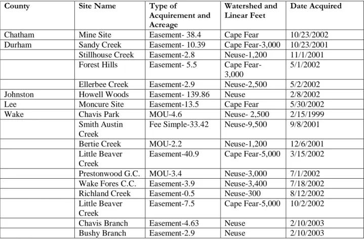
Table 5 Properties Acquired with Ecosystem Enhancement Program Funds 1999-2003
County Site Name Type of
Acquirement and Acreage
Watershed and
Linear Feet Date Acquired
Chatham Mine Site Easement- 38.4 Cape Fear 10/23/2002
Durham Sandy Creek Easement- 10.39 Cape Fear-3,000 10/23/2001 Stillhouse Creek Easement-2.8 Neuse-1,200 11/1/2001 Forest Hills Easement- 5.5 Cape Fear-
3,000
5/1/2002 Ellerbee Creek Easement-2.9 Neuse-2,500 5/2/2002
Johnston Howell Woods Easement- 139.86 Neuse 2/8/2002
Lee Moncure Site Easement-13.5 Cape Fear 5/30/2002
Wake Chavis Park MOU-4.6 Neuse- 2,500 2/15/1999
Smith Austin Creek
Fee Simple-33.42 Neuse-9,500 9/8/2001
Bertie Creek MOU-2.2 Neuse-1,200 12/6/2001
Little Beaver Creek
Easement-40.9 Cape Fear-5,000 3/15/2002
Prestonwood G.C. MOU-3.4 Neuse-3,000 7/1/2002 Wake Fores C.C. Easement-3.9 Neuse-3,400 7/18/2002 Richland Creek Easement-0.5 Neuse-300 8/12/2002 Little Beaver
Creek
Easement-7.5 Cape Fear-5,000 10/2/2002 Chavis Branch Easement-4.63 Neuse 2/10/2003
Bushy Branch Easement-2.9 Neuse 2/10/2003
29
Triangle Regional Open Space Planning Efforts
Over the last decade, there have been four key regional open space planning activities and
reports: the Triangle Green Space Database User Manual (2002), the Triangle GreenPrint
Regional Open Space Assessment (2002), the Triangle GreenPrint Progress Report (2005), and the State of Open Space 2002.
The Triangle Green Space Database User Manual (2002) was developed by the Triangle J Council of Governments and the N.C. Center for Geographic Information and Analysis in order to guide the development of a regional green space database (TJCOG, 2002). This database was to be developed in coordination with the N.C. Million Acre Initiative and the N.C. Farmland Preservation Trust Fund to assist them with tracking each program’s progress towards achieving its goals. The database was actually set up to be a set of five linked databases addressing:
protected lands, adopted plans, regional GreenPrint, trails, and unprotected lands but only the database for the GreenPrint was developed.
Although the Triangle Green Space Database was a good start to addressing regional data
collection and served as a good model for this study, there are some weaknesses to this program. Perhaps the greatest weakness is the complicated nature of the database- simply put the database requests too much information from municipalities. Other weaknesses include the lack of
continuous funding to update and maintain the database and the expectation of municipalities to submit answers to 23 attributes just for the protected lands database.
The purpose of the Triangle GreenPrint Regional Open Space Assessment was to identify
important green spaces in the region using the database described earlier (TJCOG, 2005). The report includes a series of maps that show where open spaces are located and how they are connected with each other. It also describes ways that the open spaces could be ranked and created a regional open space vision. The assessment was not intended to be a plan- it never identified specific tracts of land or recommend particular protection strategies.
However, the GreenPrint Assessment did accomplish 6 key steps:
1. Brought over 140 professionals and citizens together to discuss open space issues and
record the general location of open space areas on the regional level.
2. It established six types of open space: parks, greenways, historic areas, natural areas, water quality areas, and farm and forest land.
3. Identified criteria that could be used to prioritize land based on open space resource value.
4. Developed initial maps and lists of key resources for each type of open space.
5. Defended the value of a regional perspective in open space preservation and started
fitting all the pieces together to develop a regional vision.
30
Part of the next steps identified by the GreenPrint Assessment was the Triangle GreenPrint Progress Report prepared by the Triangle J Council of Governments in 2005. The purpose of the progress report was to analyze the vision established within the initial GreenPrint Assessment and consider what actions and financial investments would be needed to implement this vision (TJCOG, 2005). The Progress Report determined the number of acres necessary to protect the backbone of the proposed system of open space to be about 6,300 acres per year. Using this number it found that the region would need to double its current rate of protection- during the 2.5 year period between July 2002 and December 2004, only 7,000 acres were protected within the six-county area.
The Triangle GreenPrint Progress Report also performed an extensive cost analysis to determine the cost of two scenarios of land conservation. If conservation efforts were doubled now ( in 2005) for over the next 25 years, it would cost $5.2 billion to protect the 6,3000 acres per year (TJCOG, 2005). If the rate was not doubled and it took 56 years then it would cost $22.6 billion. The progress report also discussed the available local government green space plans and funding trends (past funding from 2004 to 2005 and expected appropriations up until 2007).
The previous three reports were developed through a partnership of the Triangle J Council of Governments, the Triangle Land Conservancy, and the North Carolina Department of
Environment and Natural Resources. The fourth report, the State of Open Space 2002, was
developed by the Triangle Land Conservancy in order to examine land use changes within the region, inventory land that has been protected, review non-profit and government initiatives, and recommend ways that the region can protect more land more effectively (Costa, 2002).
31
Regional Open Space Resources
Regional open space resources are those that span over two or more counties, offer a vast amount of recreational opportunities, and are usually managed through multiple partnerships or state agencies. The majority of them are preservation efforts that have taken place along water bodies such as lakes and rivers to protect water quality or prevent flooding.
B. Everett Jordan Lake
-
Spanning parts of Chatham, Durham, Orange, and Wake counties, Jordan Lake and its managed lands consist of 46,768 acres (DeHart, 2007). These lands are managed by multiple state agencies including the U.S. Army Corps of Engineers, N.C. Division of Parks and Recreation, N.C. Division of Forest Resources, N.C. Wildlife ResourcesCommission, and the Triangle Rails to Trails Conservancy. Due to multiple management agencies and the extensive span of the Jordan Lake lands, the management area has been subdivided into multiple recreation areas including: Poe’s Ridge, Ebenezer Church, New Hope Overlook and Game Lands, Seaforth, Vista Point, and the Jordan Lake Educational Forest. In addition to providing flood protection, Jordan Lake offers many recreational opportunities (hiking, boating, fishing, swimming, and camping) and serves as a major water source for the region.
Falls Lake
-
Similar to Jordan Lake, Falls Lake is an Army Corps of Engineers project that provides flood relief and is also a major source of water for Raleigh. The lake consists of 11,620 acres and is surrounded by 27,266 acres of land in Durham, Wake, and Granville counties (DeHart, 2007). The lake is divided into 12 public-use areas, of which seven are part of the Falls Lake State Recreation Area managed by the N.C. Division of Parks and Recreation. Falls Lake Trail, which consists of more than 35 miles of hiking trails and is part of the Mountains to Sea Trail, passes through game lands and connects the Rolling View, Blue Jay Point Park, and Shinleaf recreation areas.Eno River State Park
-
Located in Durham and Orange counties, Eno River State Park spans from Hillsborough to Durham and covers 2,738 acres of land and water (DeHart, 2007). The park is divided into four sections- Few’s Ford, Cabe Lands, Cole Mill Road, and Pump Station- and offers over 24 miles of trails and 12 river miles for paddling. The park is a good place to see wildflowers, river birch, sycamores, and sweet gum trees as well as the remnants of pioneer settlement along the river.32
protecting historic places used by Native American and pioneer farmers as well as rare mussel and fish species.
Deep River- The Deep River provides habitat for the endangered Cape Fear shiner, a small golden minnow. The riverbanks are lined with white pine trees and the remains of a failed river navigation system including a lock, dam and canal at Lockwood. The Deep River is an important water supply for Chatham and Lee counties and is currently threatened by increased levels of nutrients and sedimentation entering the river via its tributaries. Because of its natural and historic significance, the Triangle Land Conservancy is working to protect 4,040 acres on the Deep River including the expansion of the White Pines Nature Preserve, Endor Iron Furnance, WRC Gameland, and conservation efforts along Lockville, Patterson Creek, and Popular Creek (TLC Deep River, 2009).
Mark’s Creek- Named a Last Chance Landscape by Scenic America in 2003, Mark’s Creek is a significant area for historic and open space preservation. Consisting of 7,500 acres, this
undeveloped area has great potential to become a natural park larger than Umstead State Park. Only 10 miles from Raleigh, Mark’s Creek features historic homes and farms, country stores, ponds, wetlands, forests and rural churches including the 19th century Oaky Grove Methodist Church. The expansion of highways near this undeveloped area threatens rapid urbanization if action is not taken soon. Therefore it is considered a priority area for the Triangle Land
Conservancy, which is actively working to protect 1,685 acres in the area (TLC Mark’s Creek, 2009).
New Hope Creek- As a primary tributary of Jordan Lake, New Hope Creek starts north of Chapel
Hill, passes through Duke Forest, and meanders into Durham. The riverbanks on either side of
New Hope Creek provide some of the most important wildlife habitats in the Triangle and is home to hundreds of plant and animal species that are quickly disappearing from the region (TLC New Hope, 2009). Because of its location between Chapel Hill and Durham and along Johnston Mill Nature Preserve, Duke Forest and Githens Middle School, New Hope Creek is a popular place for hikers and nature explorers (TLC New Hope, 2009). The Triangle Land Conservancy is actively working to protect 28 acres on New Hope Creek that would include Hollow Rock Trailhead and the Steep Bottom Branch.
Duke Forest- This forest, managed for research and teaching purposes at Duke University since the early 1930s, consists of 7,060 acres in Alamance, Durham and Orange counties. Duke Forest has six divisions that offer a variety of ecosystems, forest cover types, plant species, soils, topography and past land use conditions. According to Duke’s website; “in terms of size,
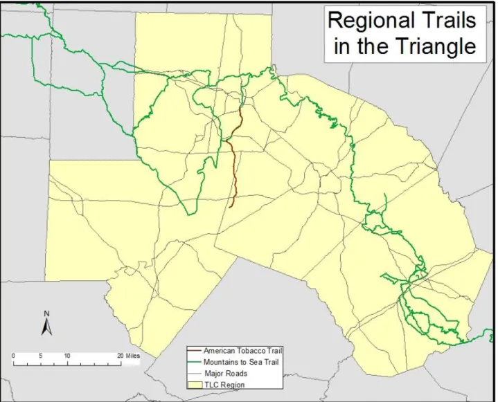
33 Regional Trails- The Triangle is also working to expand two regional trails. The American Tobacco Trail is a 22 mile rails-to-trails project connecting the City of Durham, Durham, Chatham, and Wake Counties, the jurisdictions of Cary and Apex and Jordan Lake lands (Triangle Rails-to-Trails, 2008). The Mountains to Sea Trail is a 935 mile trail consisting of footpaths, roads, and state bike routes across the state. The trail started in 1973, and passes through Orange, Durham, Wake, and Johnston counties (Friends, 2009).
Figure 6 Regional Trails in the Triangle
34
Triangle Land Conservancy Lands
The Triangle Land Conservancy has worked with its partners to conserve over 13,111 acres of land valued at over $61 million as part of the138 projects throughout the six counties it
represents. Founded in 1983, the Conservancy’s mission is “to protect important open space-stream corridors, forests, wildlife habitat, farmland and natural areas- in Chatham, Durham, Johnston, Lee, Orange and Wake counties to help keep our region a healthy and vibrant place to live and work”(About TLC, 2009). TLC has identified five priority areas- New Hope Creek, Deep River, Neuse River Lowlands, Little River, and Mark’s Creek- and three special project areas- Haw River, Upper Neuse Clean Water Initiative, and the Chatham County Working Lands Initiative. In addition to acquiring properties, TLC provides stewardship on all the property it manages and is a leader in conservation planning for the region. As a land trust, TLC offers landowners many ways to protect their land in the face of ever-growing development pressure in order to help communities save their natural heritage. A complete table of TLC properties can be found in Appendix: III.
Figure 7 Triangle Land Conservancy Conservation Lands
35
County-by-County Assessment of Open Space Conservation
The following section details a county-by-county assessment of open space conservation efforts3. It is interesting to note that the 2002 State of Open Space report recognized an “urban-rural divide” in land conservation within the Triangle, with far more land being protected in the more urban areas than in the rural areas (Costa, 2002). This notion was reinforced by study
participants, especially those in rural areas that often referenced a lack of funding (mainly bonds), staff support, or even an open space or recreation department as being major challenges they must overcome. Another aspect of open space preservation that many of the more rural areas (Orange, Johnston, Chatham, and Lee counties) are facing is the inability of citizens to visualize the effects that an increasing level of urbanization will have on their county in the next 30 or 50 years. It is difficult to sell the idea that open space needs to be protected now, when open space in the shape of farms and woodlands seem to be everywhere in these counties.
Fortunately, both Chatham County and Johnston County have recently received funding from the Farmland Preservation Trust Fund to develop agricultural preservation plans. Two other tools that are widely being used within these counties are an open space ordinance and stormwater management programs. The more rural counties are also making great strides in connecting to regional trail systems including the American Tobacco Trail and the Mountain to Sea Trail. As the more urbanized counties of Wake and Durham start to run out of large parcels of land to conserve and as land prices within these counties increase, additional land acquisitions outside of county boundaries is likely to occur. The situation is ripe for increased regional collaboration and partnerships to help decrease this divide.
3
36
Wake County
Acres Conserved: 45,646 (Falls Lake 6,512 Acres) Percent of County Conserved: 8.3%
Per Capita Conservation: 0.37 acre/person Funding Since 2002: $81M
Main Office: Wake County Parks, Recreation, & Open Space
Highlights from Plans:
Defines open space as protected lands and waters
that are owned and managed by the County or its partners. Open space is any parcel of area of land and water that is essentially unimproved and devoted to (1) the preservation of natural resources and habitat; (2) the managed production of
resources (forest and farm land): (3) outdoor recreation; (4) preservation of historic and cultural property; (5) protection of scenic landscapes; and (6) protection of public health, safety, and welfare.
Establishes a program with four major components:
(1) Identifying key parcels of land and corridors to protect; (2) Recommending new regulatory
programs to improve the protection of resources that safeguard public health, safety, and welfare; (3) Establishing a new program of land
stewardship; (4) Defining recurring sources of revenue that support conservation.
Estimates that 78% of the county land area will be
developed by 2020 if conservation efforts are not increased dramatically.
Received $41 million through referendums in 2000
and 2004 for open space preservation.
Identifies water quality, ecological values,
economic values, connectivity, and sense of place as the benefits of open space protection and the plans focus areas.
Wake County Consolidated Open Space Plan
contains plans from 11 individual municipalities.
County Statistics and Plans:
Area:
Total- 857 sq mi
Land- 832 sq mi
Water- 25 sq mi
Population:
2008 Estimate- 829,218
Population Density- 997/sq mi
Plans:
Comprehensive Parks and
Recreation Master Plan
Wake County Consolidated
Open Space Plan
Trails and Greenways of
Wake County, Pocket Guide and Community Resource
Wake County Land Use Plan
Wake County Growth
37 Major Open Space:
William B. Umstead State Park
-
Described as a “valuable oasis in the center of a fast-developing metropolitan area,” Umstead Park covers 5,480 acres and is one of the state’s largest parks (DeHart, 2007). Situated next to Raleigh-Durham International Airport, U.S. 70 and I-40, Umstead started as a Civilian Conservation Corps camp in the 1930s. Reedy Creek initially served as a divide between the African American Reedy Creek State Park and the Caucasian Crabtree Creek State Park that were joined in 1966 as Umstead Park. The park contains some of the oldest trees in the state with large mature stands of oaks, yellow poplars, sycamores, loblolly pines, and an understory of dogwoods, redbuds, mountain laurel, and sourwood. Parts of the park are listed on the National Registry of Natural Landmarks and serve as critical habitat for specie protection. With over 35 miles of hiking and mix use trails, Umstead is a critical recreation area for Wake County.Hemlock Bluffs Nature Preserve
-
Named after the eastern hemlock, a conifer not usually found farther east than Hanging Rock State Park, this 150-acre preserve has over 200 of theseevergreens (DeHart, 2007). The conditions found within the preserve are similar to those found in the Appalachian Mountains with cool, damp, north-facing bluffs with hemlock, yellow orchids, trillium, and chestnut oak. The preserve has an educational center and 2.1 miles of trail.
Source: North Carolina Parks
38
39
Durham County
Acres Conserved: 34,705 (Falls Lake 4,827 Acres; Jordan Lake 124 Acres)
Percent of County Conserved: 37.5% Per Capita Conservation: 0.27 acre/person Funding Since 2002: $11M
Main Office: Durham Open Space and Real Estate Division Highlights from Plans:
Determines a level of service standards for open
space protection in the City and County.
Recommends planning to interconnect open
spaces, identify areas for protection, and guide park development.
Proposes developing a plan for Eastern Durham
(which has been completed) and urban open space protection efforts (which is currently being worked on).
Promotes collaboration with local land trusts and
other community organizations to increase the amount of open space protection and develop an open space coordinating group.
The county designates agricultural priority areas, has a voluntary agricultural districts program, and purchase farmland conservation easements.
Sets requirements for new residential
development to provide recreation facilities and recreation impact fees.
Identifies open space areas within the future land use map including the 100-year floodplains, US Army Corps of Engineers land, Eno River State Park, Duke Forest, NCSU Hill Forest, Lake Crabtree lands, Lake Michie, Little River Reservoir, New Hope Corridor, and parks, privately-owned conservation lands, abandoned railroad corridors and historic sites.
County Statistics and Plans:
Area:
Total- 298 sq mi
Land- 290 sq mi
Water- 7 sq mi
Population:
2008 Estimate- 262,715
Population Density- 769/sq mi
Plans:
Durham Comprehensive Plan
New Hope Corridor Open
Space Master Plan
Eastern Durham Open Space
Plan
Little River Corridor Open
Space Plan
Durham Trails and Greenways
40 Major Open Spaces:
Hill Demonstration Forest
-
Spanning both sides of the Flat River, the 2,400 acre Hill Forest is owned and managed by North Carolina State University as a forest research laboratory (DeHart, 2007).
Permission to access the forest’s four trails is required.Camp Butner- The North Carolina National Guard uses this 4,750 acre reserve for training (Global Security, 2005). The camp is within Granville and Durham counties and is 15 miles away from the City of Durham. Established in 1942 and named in honor of Major General Henry Wolfe Butner, the camp originally served as a training area for combat soldiers, a military
hospital, and a prisoners of war camp. At the end of World War II, the camp was closed until it was converted to a hospital for the mentally ill in 1947. The land is currently divided into the North Carolina Department of Agriculture Umstead Research Farm, a Federal Correctional Complex, and training grounds for the National Guard. The hardwood forests found within the camp provide habitat for a wide diversity of small game species.
Source: Friends of Hill Forest
41