Original Research Article
Impact of different centroid means on the accuracy of orthometric
height modelling by geometric geoid method
Oluyori P. Dare*, Eteje S. Okiemute
INTRODUCTION
A centroid is defined as the point whose coordinates are the average values of the coordinates of all points of the figure (polygon).1 It relates to the concept of central
tendency of mean, median and mode.2 Further, that the
mean is a type of average that is a single value used to represent every element in the dataset but can be classified into arithmetic mean, root mean square, harmonic mean and geometric mean.
It is very important to realize that mean has a centring property which implies that when it (mean) is subtracted from each observation in the dataset, the sum of the
differences is zero for a normally distributed data. The use of normalized coordinates in the interpolation of geoid undulation and determination of orthometric heights require of the centroid mean techniques along with the observed coordinates in the absolute form. This is required for referencing coordinates for manipulation and computation of geoid and subsequent geoid computation.
Real numbers are governed by the following features of: measurability i.e. has three sides on a number line: infinite negative side; infinite positive side; a zero in between. Value can be attached e.g. 7.345. Manipulated by mathematical operations (subtraction, addition,
ABSTRACT
Background: Orthometric height, as well as geoid modelling using the geometric method, requires centroid computation. And this can be obtained using various models, as well as methods. These methods of centroid mean computation have impacts on the accuracy of the geoid model since the basis of the development of the theory of each centroid mean type is different. This paper presents the impact of different centroid means on the accuracy of orthometric height modelling by geometric geoid method.
Methods: DGPS observation was carried out to obtain the coordinates and ellipsoidal heights of selected points. The centroid means were computed with the coordinates using three different centroid means models (arithmetic mean, root mean square and harmonic mean). The computed centroid means were entered accordingly into a Microsoft Excel program developed using the Multiquadratic surface to obtain the model orthometric heights at various centroid means. The root means square error (RMSE) index was applied to obtain the accuracy of the model using the known and the model orthometric heights obtained at various centroid means.
Results: The computed accuracy shows that the arithmetic mean method is the best among the three centroid means types.
Conclusions: It is concluded that the arithmetic mean method should be adopted for centroid computation, as well as orthometric height modelling using the geometric method.
Keywords: Geoid, Centroid, Arithmetic, Root mean square, Harmonic, Mean, Orthometric height Department of Surveying and Geoinformatics, Nnamdi Azikiwe University, Awka, Anambra State, Nigeria
Received: 21 January 2020
Accepted: 03 March 2020
*Correspondence:
Dr. Oluyori P. Dare,
E-mail: [email protected]
Copyright: © the author(s), publisher and licensee Medip Academy. This is an open-access article distributed under the terms of the Creative Commons Attribution Non-Commercial License, which permits unrestricted non-commercial use, distribution, and reproduction in any medium, provided the original work is properly cited.
division and multiplication) of real numbers to yield another set of real numbers.
e.g., 5 × 4 = 20, 3 / 2 = 1.5
Due to the features of real numbers espoused above, some relationships were derived to enable the computation of different centroid means as listed under the theoretical background.3 In summary, a commonly
accepted meaning of the centroid is equivalent to the ‘centre of mass’.4 Centroid determination allows x, y
coordinates of an area to locate the points whose orthometric heights have the least root mean square error (RMSE) among arithmetic mean, root mean square mean and harmonic mean. In this, the centroid is computed with the same dataset using the arithmetic mean, root mean square mean and harmonic mean. The differences between the various centroid mean types and the observations (orthometric heights) are evaluated to obtain the residuals. The centroid mean type with the least sum of the square of the residuals has the least root mean square error. Thus, has the highest accuracy.
Practical application area of centroid principle is in the modelling of various aspects of ‘orientation disorder in crystals in electron density distribution for example in distraction experiments’ i.e., in crystallographic problems.5 Other areas are in geoidal undulation
determination and terrain correction in gravity studies.
The ellipsoid and the geoid reference surfaces are used to represent the figure of the earth that are involved in geodetic, as well as geophysical applications. Several studies have determined the local geoid models of various areas using the geometric method.6-9 This method
requires the computation of the centroid of the study area. The centroid computation can be done with several methods such as geometric mean, arithmetic mean, root mean square and harmonic mean centroids. Each of these methods of centroid computation has an effect on the accuracy of the determined geoid model as the development of each centroid mean type is based on different theories. None of the studies on local geoid model determination using the geometric method has applied the various methods of centroid mean computation and compared their accuracy to determine the best method. So, there is a need to determine the impact, as well as the effect of the various methods of centroid computation on the accuracy of the geometric geoid, as well as orthometric height modelling. The objectives of this study are: to determine and compare the impacts of different centroid means on the accuracy of orthometric height modelling by geometric geoid method and to determine the best method for centroid mean computation.
Theoretical background
Mean as a type of average comprises geometric, arithmetic, root mean square and harmonic means.3 The
four centroid means and the geometric means are given in equation.3 P P n P P P
n
x
x
x
M
/ 1 2 1...
+
+
+
=
(1)Where,
P
M
is pth-power meann
x
x
x
1,
2,
.
.
.
,
set of real numbersGeometric mean
The geometric mean G is given as
n n
x
x
x
G
=
(
1,
2,
.
.
.
,
)
1/ (2)Arithmetic mean centroid
(
M
1)
The arithmetic mean centroid is obtained by putting p = 1 into equation (1), the model for the computation of the centroid
(
x
,
y
)
mean is given in equation (3).4n
x
x
n k k
==
1 andn
y
y
n k k
==
1 (3)Root mean square centroid
(
M
2)
Substituting p = 2 into equation (1), the root mean square centroid
(
x
,
y
)
can be computed asn
x
x
n k k
==
1 2 andn
y
y
n k k
==
1 2 (4)Harmonic mean centroid
(
M
−1)
Also, p = -1, the harmonic centroid
(
x
,
y
)
can be computed asn
x
x
n k k
==
11
1
andn
y
y
n k k
==
11
1
(5)Equations (3) to (5) were used to compute the various centroid values needed for interpolation of geoid and orthometric heights.
it is based on different assumptions. For a set of n
numbered values arranged from either smallest to largest or vice versa, when n is odd, then the middle value becomes the median. For n is even the mean of a pair of middle values is taken as the median.
Geometric geoid models
Geometric geoid models are determined by finding the differences between the ellipsoidal and the orthometric heights of selected points to obtain the geoid heights of the points.10 A geometric geoid surface is then fitted to
the computed geoid heights of the points to enable geoid heights of new points within the study area be computed. Polynomial surfaces are used to represent continuous surfaces over study areas.11 The Multiquadratic surface
used for the interpolation of geoid heights is given in equation (6).11
2 2 8 2 7 2 6 5 2 4 2 3 2 1
0 aX aY aX aY aXY a X Y a XY a X Y a
N= + + + + + + + +
- (6)
Where,
) (
) (
o o
x x ABS X
y y ABS Y
− =
− =
y
= Northing coordinate of observed station.x
= Easting coordinate of observed station.o
y
= Northing coordinate of the origin (average of the northing coordinates).o
x
= Easting coordinate of the origin (average of the easting coordinates).N is geoidal undulation at the point of interest.
n
a
a
a
a
0,
1,
2,
.
.
.,
unknown parameters.The relationship between the orthometric height (H), ellipsoidal height (h) and the geoid height (N) is given in equation (7).11
H= h-N (7)
Computation of root mean square error
The modelling of orthometric heights using the geometric geoid method requires the computation of the model accuracy with the root mean square error (RMSE) index. To compute the accuracy of the model, the orthometric heights of points from the model that is, the orthometric heights of the points obtained from the differences between the model geoid heights and the ellipsoidal heights of the points are compared with their corresponding existing, as well as spirit levelling orthometric heights to obtain the orthometric height residuals. The orthometric height residuals and the total number of the selected points are used for the computation of the RMSE, as well as the accuracy of the model. The RMSE index for the computation of the model accuracy is given in equation (8).12
(
)
=
= n
i
H n RMSE
1
2 Residual 1
(8)Where,
)
Model KNOWNResidual
H
H
H
=
−
=
KNOWN
H
Known Orthometric HeightModel
H
= Model Orthometric Height Pointsof Number =
n
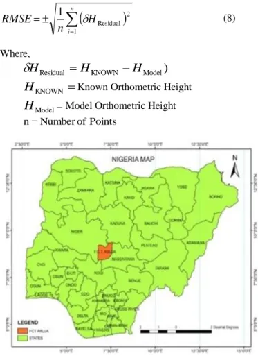
Figure 1: Map of the Nigerian states and FCT Abuja source: Arcinfo shapefile 2010 (ESRI).
Dataset available
In this study, the following datasets were available: list of coordinates obtained from the survey and mapping department, federal capital development authority (FCDA), Abuja. CSRS-PPP post-processed DGPS coordinates and ellipsoidal heights. Nigeria and federal capital territory (FCT) maps (Figures 1 and 2).
METHODS
DGPS coordinates (observations)
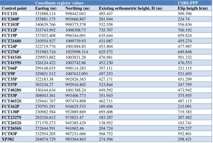
Hi-target V30 pro geodetic DGPS dual-frequency receivers were used for data capture in the relative mode of GPS observation. During the observation, each point was occupied for about 2 hours. The observations (RINEX data) were post-processed using CSRS-PPP online software. The results are shown in (Table 1).
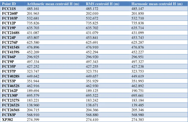
Using the post-processing results presented in Table 1, the computations of root mean square centroid was done with equation (4), that of arithmetic mean centroid was done using equation (3) and that of the harmonic mean centroid was carried out with equation (5) as respectively shown in (Table 2 and 3).
The summary, as well as the results of the arithmetic mean, root mean square and the harmonic mean centroids are shown in (Table 4).
A microsoft excel program that was developed using the multiquadratic surface (equation (6)) for interpolation of geoid heights, as well as modelling of orthometric heights within the federal capital territory (FCT), Abuja was used in this study. The computed centroid means were entered accordingly one after the other into the developed program to obtain their respective model orthometric heights as given in (Table 5).
The differences in the respective orthometric heights in Table 5, may arise from the different basis of the development of the theory of each centroid mean type.
The accuracy of the model was computed for each of the calculated centroid means.
The computation was done by comparing the obtained orthometric heights for each centroid mean with the known/spirit levelling orthometric heights using equation (8).
Table 1: Control points coordinates and ellipsoidal heights.
Coordinate register values CSRS-PPP
Control point Easting (m) Northing (m) Existing orthometric height, H (m) Elip heigth h(m)
FCC11S 331888.114 998442.043 485.447 509.396
FCT260P 255881.175 993666.807 201.944 224.74
FCT103P 340639.766 998375.578 532.558 556.836
FCT12P 333743.992 1008308.73 735.707 760.192
FCT19P 337452.408 996344.691 635.644 659.824
FCT2168S 310554.927 1009739.93 431.087 455.274
FCT24P 322719.776 1001884.85 453.804 477.987
FCT276P 351983.716 1025998.314 625.572 649.848
FCT4154S 329953.882 1003831.28 476.981 501.232
FCT4159S 326124.422 1003742.86 452.230 476.553
FCT66P 299148.035 998114.283 297.111 321.115
FCT9P 329821.512 1007612.091 497.253 521.693
FCT35P 322183.38 992926.363 427.171 451.299
FCT57P 303234.27 992916.402 323.844 347.795
FCT4028S 330164.634 1001388.24 449.592 473.942
FCT53P 308943.361 993406.773 351.943 375.955
FCT4652S 329441.767 997474.808 462.711 487.113
FCT162P 270791.291 934625.533 189.696 215.091
FCT130P 330982.584 952889.869 695.608 719.383
FCT2327S 282526.612 973821.47 183.287 207.482
FCT2652S 271370.273 945385.429 138.952 163.741
FCT2656S 272644.591 941062.46 204.724 229.237
FCT83P 332954.205 987231.606 568.752 592.801
XP382 284074.729 983364.863 274.586 298.421
Tables 2: Root mean square centroid computation.
Point ID Easting SQ Easting Northing SQ Northing
FCC11S 331888.114 110149720214.477 998442.043 996886513230.014
FCT260P 255881.175 65475175719.381 993666.807 987373723333.575
Point ID Easting SQ Easting Northing SQ Northing
FCT12P 333743.992 111385052196.096 1008308.73 1016686494994.210
FCT19P 337452.408 113874127664.998 996344.691 992702743283.885
FCT2168S 310554.927 96444362683.975 1009739.93 1019574726236.410
FCT24P 322719.776 104148053821.490 1001884.85 1003773252659.520
FCT276P 351983.716 123892536329.169 1025998.314 1052672540330.840
FCT4154S 329953.882 108869564246.870 1003831.28 1007677238706.440
FCT4159S 326124.422 106357138624.834 1003742.86 1007499729000.980
FCT66P 299148.035 89489546844.361 998114.283 996232121928.604
FCT9P 329821.512 108782229777.966 1007612.091 1015282125929.390
FCT35P 322183.38 103802130348.224 992926.363 985902762340.408
FCT57P 303234.27 91951022502.433 992916.402 985882981360.626
FCT4028S 330164.634 109008685544.354 1001388.24 1002778407210.300
FCT53P 308943.361 95446000305.976 993406.773 986857016642.274
FCT4652S 329441.767 108531877844.082 997474.808 994955992594.637
FCT162P 270791.291 73327923281.447 934625.533 873524886935.534
FCT130P 330982.584 109549470911.317 952889.869 907999102442.837
FCT2327S 282526.612 79821286488.199 973821.47 948328255432.961
FCT2652S 271370.273 73641825068.095 945385.429 893753609365.514
FCT2656S 272644.591 74335073001.557 941062.46 885598553621.252
FCT83P 332954.205 110858502627.182 987231.606 974626243885.339
XP382 284074.729 80698451656.423 983364.863 967006453783.009
Total no. of points=24
Summation of SQ
Easting (A) = 2365875207883.440
Summation of SQ
Northing (B)= 23500329269995.400 (A)/24 = 98578133661.810 (B)/24 = 979180386249.808
Computed RMS centroid 313971.5491 989535.4396
Table 3: Arithmetic and harmonic means centroid computation.
Coordinate register value CSRS-PPP
Control point Easting (m) Northing (m) Existing orthometric height,
(m) Elip height (m)
FCC11S 331888.114 998442.043 485.447 509.396
FCT260P 255881.175 993666.807 201.944 224.74
FCT103P 340639.766 998375.578 532.558 556.836
FCT12P 333743.992 1008308.73 735.707 760.192
FCT19P 337452.408 996344.691 635.644 659.824
FCT2168S 310554.927 1009739.93 431.087 455.274
FCT24P 322719.776 1001884.85 453.804 477.987
FCT276P 351983.716 1025998.314 625.572 649.848
FCT4154S 329953.882 1003831.28 476.981 501.232
FCT4159S 326124.422 1003742.86 452.230 476.553
FCT66P 299148.035 998114.283 297.111 321.115
FCT9P 329821.512 1007612.091 497.253 521.693
FCT35P 322183.38 992926.363 427.171 451.299
FCT57P 303234.27 992916.402 323.844 347.795
FCT4028S 330164.634 1001388.24 449.592 473.942
FCT53P 308943.361 993406.773 351.943 375.955
FCT4652S 329441.767 997474.808 462.711 487.113
FCT162P 270791.291 934625.533 189.696 215.091
FCT130P 330982.584 952889.869 695.608 719.383
FCT2327S 282526.612 973821.47 183.287 207.482
FCT2652S 271370.273 945385.429 138.952 163.741
FCT2656S 272644.591 941062.46 204.724 229.237
FCT83P 332954.205 987231.606 568.752 592.801
Coordinate register value CSRS-PPP
Control point Easting (m) Northing (m) Existing orthometric height,
H (m) Elip height h(m)
XP382 284074.729 983364.863 274.586 298.421
Summation 7509223.422 23742555.27
Arithmetic mean 312884.3093 989273.1364
Harmonicmean 310555.900 988733.816
Total no. of points=24
Table 4: Arithmetic mean, root mean square, harmonic mean centroid values.
Centroid type Easting (X0) m Northing (Y0) m Remarks
Arithmetic mean M1 312884.309 989273.136
Root means square mean M2 313971.549 989535.440
Harmonic mean M-1 310555.900 988733.816
Table 5: Orthometric heights obtained for different centroid means.
Point ID Arithmetic mean centroid H (m) RMS centroid H (m) Harmonic mean centroid H (m)
FCC11S 485.161 485.172 485.147
FCT260P 201.963 202.010 201.850
FCT103P 532.681 532.672 532.710
FCT12P 735.826 735.825 735.838
FCT19P 635.703 635.702 635.714
FCT2168S 431.087 431.079 431.099
FCT24P 453.807 453.841 453.743
FCT276P 625.580 625.691 625.287
FCT4154S 476.896 476.910 476.876
FCT4159S 452.269 452.294 452.227
FCT66P 296.925 296.920 296.951
FCT9P 497.334 497.343 497.327
FCT35P 427.252 427.255 427.238
FCT57P 323.747 323.751 323.753
FCT4028S 449.642 449.657 449.619
FCT53P 351.944 351.929 351.993
FCT4652S 462.916 462.930 462.892
FCT162P 189.694 189.125 190.751
FCT130P 695.579 695.522 695.661
FCT2327S 183.221 183.242 183.184
FCT2652S 138.960 138.671 139.485
FCT2656S 204.715 204.366 205.346
FCT83P 568.910 568.880 568.980
XP382 274.399 274.410 274.383
RESULTS
Table 6, presents the accuracy of the model at various centroid means. This was done to show that the various centroid means types used in local geoid, as well as orthometric height modelling, have impacts on the accuracy of the model and to determine which of the centroid mean types is the best for geometric geoid model centroid mean computation.
Table 6: RMSE of different centroid means.
Centroid mean type
Arithmetic mean (m)
Root mean square (m)
Harmonic mean (m)
Orth. height RMSE (m)
DISCUSSION
It can be seen from Table 6, that the computed RMSE, as well as the accuracy of the arithmetic mean, root mean square and the harmonic mean centroids are respectively 0.110m, 0.187m and 0.303m. This implies that the centroid mean type used in geometric geoid, as well as orthometric height modelling, has an impact on the accuracy of the model. The variation in the accuracy of the model was as a result of the different theory which each centroid mean type development was based. It can also be seen from Table 6, that the arithmetic mean centroid has the smallest RMS error, as well as the highest accuracy which also shows that the arithmetic mean centroid is the best for geometric geoid, as well as orthometric height modelling. The centroid mean whose accuracy is the highest gives the most accurate interpolated orthometric height. The various centroid mean types have not really been applied and compared in any previous study.6-9
CONCLUSION
In conclusion, the results obtained in this study has shown that the centroid mean type used in local geometric geoid, as well as orthometric height modelling, has an impact on the accuracy of the model. The study has also revealed that the arithmetic mean centroid computation method is the best.
Recommendations
It is recommended that the arithmetic mean method should be adopted for centroid computation, as well as orthometric height modelling using the geometric method.
Funding: No funding sources Conflict of interest: None declared Ethical approval:Not required
REFERENCES
1. Geodetic Glossary Survey. Geodetic Glossary, United States National Geodetic Survey, Rockville, Maryland, USA 1986.
2. Reichmann WJ. Use and Abuse of Statistics, Penguin Books, Middlesex, England 1961.
3. Apostol TM. Calculus, Vol. 1, 2nd Edn, Blaisdell Publishing Co., London 1967.
4. Deakin RE, Grenfell RI, Bird SC. The Centroid, where would you like it to be, RMIT University, GPO Box 2476V Melbourne VIC 3001 2002. 5. Madler F, Behrends E, Knorr K. A Geometric
Centroid Principle and its Application. Acta Cryst. 2001;57:20-33.
6. Erol B, Celik RN. Precise Local Geoid Determination to Make GPS Technique More Effective in Practical Applications of Geodesy. FIG Working Week, Athens, Greece. 2004;22:1-13. 7. Odera PA, Musyoka SM, Gachari MK. Practical
Application of the Geometric Geoid for Heighting Over Nairobi County and Its Environs. Jomo Kenyatta University of Agriculture and Technology. 2014;16(2):175-85.
8. Gwaleba MJ. Comparison of Global Geoid Models Against the GPS/Levelling-Derived Geoid Heights in Tanzania. J of Geomatics. 2018;12(2):174-82. 9. Tata H, Ono MN. A Geometric Approach for
Determination of Geoidal Height in Akure Environs, Ondo State, Nigeria. Inte J of Scientific and Res Pub. 2018;8(8):668-77.
10. Oluyori PD, Eteje SO. Spatial Distribution of Survey Controls and Effect on Accuracy of Geometric Geoid Models (Multi-quadratic and Bicubic) in FCT, Abuja. Scientific Res J (SCIRJ). 2019;7(5):29-35.
11. Oluyori PD, Ono MN, Eteje SO. Comparison of Two Polynomial Geoid Models of GNSS/Levelling Geoid Development for Orthometric Heights in FCT, Abuja. Inte J of Engineering Res and Advanced Techno (IJERAT). 2018;4(10):1-9. 12. Oduyebo OF, Ono MN, Eteje SO. Comparison of
Three Gravimetric-Geometric Geoid Models for Best Local Geoid Model of Benin City, Nigeria. Inte J of Advanced Engineering Res and Sci (IJAERS). 2019;6(12):261-72.