United States
Department of the Interior
Bureau of Land Management
Land Use Planning Handbook
Table of Contents
I. Introduction ...1
A. The Purpose of This Handbook and the Need for Planning Guidance ...1
B. The Basic Planning Process ...2
C. Forms of Public and Intergovernmental Involvement...2
D. Collaborative Planning...4
E. Coordination and Cooperation with Other Federal Agencies and State and Local Governments ...5
F. Government-to-Government Coordination with Indian Tribes ...9
II. Land Use Plan Decisions...11
A. Introduction...11
B. Types of Land Use Plan Decisions ...12
C. Geographic Areas...14
D. Scale of Planning ...14
E. Multijurisdictional Planning...15
F. Establishing Management Direction for Lands that May Come Under the BLM Jurisdiction in the Future. ...15
III. Land Use Planning Process and Products...16
A. Planning for Environmental Impact Statement-level Efforts...16
B. Planning for Environmental Assessment-level Efforts ...25
IV. Implementation ...29
A. Implementing Land Use Plans ...29
B. Defining Implementation Decisions...29
C. Making Implementation Decisions ...30
D. Making Land Use Plan and Implementation Decisions in the Same Planning Effort...30
E. Developing Strategies to Facilitate Implementation of Land Use Plans ...31
V. Monitoring, Evaluation, and Adaptive Management...32
A. Monitoring ...32
B. Evaluation...33
C. Adaptive Management ...36
VI. Determining if New Decisions are Required...37
A. Specific Regulatory Requirements for Considering New Information or Circumstances...37
B. Considering New Proposals, Circumstances, or Information ...37
C. Deciding Whether Changes in Decisions or the Supporting NEPA Analyses are Warranted...38
D. Documenting the Determination to Modify, or Not to Modify, Decisions or NEPA Analysis...41
E. Evaluating New Proposals...41
F. Plan Conformance ...42
G. Plan Conformance and Ongoing NEPA Activities ...42
H. Determining When to Update Land Use Plan Decisions Through Maintenance Actions...44
VII. Amending and Revising Decisions ...44
A. Changing Land Use Plan Decisions...44
B. Determining When it is Necessary to Amend Plans and How it is Accomplished...45
C. Determining When it is Necessary to Revise an RMP or Replace an MFP...46
D. Changing Implementation Decisions ...46
E. Status of Existing Decisions During the Amendment or Revision Process ...47
F. Coordinating Simultaneous Planning/NEPA Processes ...47
Glossary of Terms and Acronyms ...Glossary - 1 Terms ...Glossary - 1 Acronyms ...Glossary - 9
Appendix A: Guide to Collaborative Planning...Appendix A, page 1 I. Principles ...Appendix A, page 1 II. Practices ...Appendix A, page 2 III. Benefits ...Appendix A, page 3 IV. Tools ...Appendix A, page 3
Appendix B: Federal Advisory Committee Act Considerations...Appendix B, page 1 I. Purpose ...Appendix B, page 1 II. Implementing FACA...Appendix B, page 1 A. Avoiding Violations...Appendix B, page 1 B. Determining if FACA Applies ...Appendix B, page 2 C. FACA Requirements ...Appendix B, page 2
Appendix C: Program-Specific and Resource-Specific Decision Guidance ...Appendix C, page 1 I. Natural, Biological, and Cultural Resources ...Appendix C, page 2 A. Air ...Appendix C, page 2 B. Soil and Water...Appendix C, page 2 C. Vegetation ...Appendix C, page 3 D. Special Status Species...Appendix C, page 4 E. Fish and Wildlife ...Appendix C, page 6 F. Wild Horses and Burros...Appendix C, page 7 G. Cultural Resources ...Appendix C, page 8 H. Paleontology...Appendix C, page 10 I. Visual Resources ...Appendix C, page 11 J. Wildland Fire Management...Appendix C, page 11 K. Wilderness Characteristics...Appendix C, page 12 L. Cave and Karst Resources ...Appendix C, page 13 II. Resource Uses ...Appendix C, page 13 A. Forestry ...Appendix C, page 13 B. Livestock Grazing ...Appendix C, page 14 C. Recreation and Visitor Services ...Appendix C, page 15 D. Comprehensive Trails and Travel Management ...Appendix C, page 17 E. Lands and Realty ...Appendix C, page 20
F. Coal...Appendix C, page 21 G. Oil Shale……….Appendix C, page 23 H. Fluid Minerals: Oil and Gas, Tar Sands, and
Geothermal Resources………..Appendix C, page 23 I. Locatable Minerals ……… Appendix C, page 24 J. Mineral Materials ……… ...Appendix C, page 25 K. Non-energy Leasable Minerals ...Appendix C, page 26 III. Special Designations ...Appendix C, page 27 A. Congressional Designations...Appendix C, page 27 B. Administrative Designations ...Appendix C, page 27 IV. Support...Appendix C, page 28 A. Cadastral...Appendix C, page 29 B. Interpretation and Environmental Education ...Appendix C, page 29 C. Transportation Facilities………...Appendix C, page 30
Appendix D: Social Science Considerations in Land Use
Planning Decisions...Appendix D, page 1 I. Using Social Science in Land Use Planning ...Appendix D, page 1 II. Incorporating Socio-economic Information ...Appendix D, page 2 A. The Planning Process ...Appendix D, page 2 B. Objectives of the Analysis...Appendix D, page 2 C. The Scope of Analysis...Appendix D, page 4 D. Deliverables in Contracting ...Appendix D, page 8 E. Analytic Guidelines ...Appendix D, page 8 III. Public Involvement ...Appendix D, page 10
A. Integrating Social Science into Public Involvement ...Appendix D, page 10 B. Economic Strategies Workshop ...Appendix D, page 10 IV. Environmental Justice Requirements ...Appendix D, page 11 A. BLM’s Environmental Justice Principles ...Appendix D, page 11 B. Incorporating Environmental Justice Efforts in the
RMP/EIS Process...Appendix D, page 12 C. Documentation and Analysis ...Appendix D, page 13 V. Data Management ...Appendix D, page 13 A. Types of Data ...Appendix D, page 13 B. Data Quality and Analytic Soundness...Appendix D, page 13 C. Paperwork Reduction Act Requirements for
New Data Collection...Appendix D, page 14 VI. Data Sources ...Appendix D, page 14 A. Use of the Economic Profile System ...Appendix D, page 14 B. References ...Appendix D, page 15 C. Environmental Justice References ...Appendix D, page 17 VII. Further Guidance...Appendix D, page 17
Appendix E: Summary of Protest and Appeal Provisions ...Appendix E, page 1 I. Land Use Plan Protests ...Appendix E, page 1 A. Washington Office Initial Evaluation of Protests ...Appendix E, page 1
B. State Office Evaluation and Determination ...Appendix E, page 4 C. Washington Office Final Review...Appendix E, page 6 D. Receiving, Managing, and Responding to Electronic Mail
and Faxed Protests ...Appendix E, page 12 E. State Director’s Protest Analysis...Appendix E, page 13 II. Governor’s Consistency Review Appeal Process ...Appendix E, page 14 III. Administrative Remedies of Implementation Decisions ...Appendix E, page 14
Appendix F: Standard Formats for Land Use Plan Documents...Appendix F, page 1 Appendix F-1: Recommended Format for Preparation Plans...Appendix F, page 1 Appendix F-2: Recommended Format for Scoping Reports ...Appendix F, page 4 Appendix F-3: Annotated Outline of the Analysis of the
Management Situation ...Appendix F, page 6 Appendix F-4: Annotated Outline for a Draft and
Final RMP (Amendment)/EIS ...Appendix F, page 14 Appendix F-5: Annotated Outline for Record of Decision
(ROD)/Approved RMP (Amendment) ...Appendix F, page 20 Appendix F-6: Recommended Administrative Record File
Plan for Land Use Planning Projects ...Appendix F, page 24
Appendix G: Managing and Applying Data and Information ...Appendix G, page 1 I. Metadata Standards and Requirements...Appendix G, page 1 II. Identifying Data Needs for a Land Use Plan...Appendix G, page 1 III. Data Sources ...Appendix G, page 2 IV. Managing Data During Land Use Plan Development ...Appendix G, page 2 V. Integrating Data Application and Display ...Appendix G, page 3
I. Introduction
A. The Purpose of This Handbook and the Need for Planning Guidance
This Handbook provides supplemental guidance to the Bureau of Land Management (BLM) employees for implementing the BLM land use planning requirements established by Sections 201 and 202 of the Federal Land Policy and Management Act of 1976 (FLPMA, 43 U.S.C. 1711-1712) and the regulations in 43 Code of Federal Regulations (CFR) 1600. Land use plans and planning decisions are the basis for every on-the-ground action the BLM undertakes. Land use plans include both resource management plans (RMPs) and management framework plans (MFPs).
Land use plans ensure that the public lands are managed in accordance with the intent of
Congress as stated in FLPMA (43 U.S.C. 1701 et seq.), under the principles of multiple use and sustained yield. As required by FLPMA and BLM policy, the public lands must be managed in a manner that protects the quality of scientific, scenic, historical, ecological, environmental, air and atmospheric, water resource, and archaeological values; that, where appropriate, will preserve and protect certain public lands in their natural condition; that will provide food and habitat for fish and wildlife and domestic animals; that will provide for outdoor recreation and human occupancy and use; and that recognizes the Nation’s need for domestic sources of minerals, food, timber, and fiber from the public lands by encouraging collaboration and public participation throughout the planning process. Land use plans are one of the primary
mechanisms for guiding BLM activities to achieve the mission and goals outlined in the Department of the Interior (DOI) Strategic Plan.
This Handbook provides guidance for preparing, revising, amending, and maintaining land use plans. This Handbook also provides guidance for developing subsequent implementation (activity-level and project-specific) plans and decisions. It builds on field experience gained in implementing the 1983 planning regulations (43 CFR 1600), subsequent BLM Manual guidance, and the 2000 Handbook. This guidance does not, however, change or revise the planning
regulations in 43 CFR 1600, which take precedence over this Handbook. Definitions for terms used in this Handbook are found in the glossary and in the BLM planning regulations in 43 CFR 1601.0-5.
Any interpretation of the guidance contained in this Handbook is subservient to the legal and regulatory mandates contained in FLPMA, 43 CFR 1600, the National Environmental Policy Act of 1969 (NEPA, 42 U.S.C. 4321 et seq.), the Council on Environmental Quality (CEQ)
regulations at 40 CFR 1500-1508, and other applicable Federal laws and regulations. This planning guidance:
1. Encourages planning on a variety of scales, including both local and regional, in partnership with other landowners and agencies;
2. encourages active public participation throughout the planning process and facilitates multijurisdictional planning;
3. clarifies the relationship between land use plans and implementation plans (implementation plans include both activity-level and project-specific plans);
4. provides procedural requirements for completing land use plans and implementation plans;
5. clarifies the relationships between land use and implementation planning and NEPA requirements;
6. addresses new requirements and approaches for managing public lands or resources; and
7. addresses the consideration of new information and circumstances, e.g., new listings of threatened and endangered species, and new requirements and standards for the protection of air and water quality, etc.
B. The Basic Planning Process
The BLM will use an ongoing planning process to ensure that land use plans and implementation decisions remain consistent with applicable laws, regulations, orders, and policies. This process will involve public participation, assessment, decision-making, implementation, plan monitoring, and evaluation, as well as adjustment through maintenance, amendment, and revision. This process allows for continuous adjustments to respond to new issues and changed circumstances. The BLM will make decisions using the best information available. These decisions may be modified as the BLM acquires new information and knowledge of new circumstances relevant to land and resource values, uses, and environmental concerns. Modifying land use plans through maintenance and amendment on a regular basis should reduce the need for major revisions of land use plans.
C. Forms of Public and Intergovernmental Involvement
Planning is inherently a public process. The BLM uses a number of involvement methods to work with members of the public, interest groups, and governmental entities.
• Public involvement entails “The opportunity for participation by affected citizens in rule making, decision making, and planning with respect to the public lands, including public meetings or hearings . . . or advisory mechanisms, or other such procedures as may be necessary to provide public comment in a particular instance” (FLPMA, Section 103(d)). Several laws and Executive orders set forth public involvement requirements, including maintaining public participation records. The BLM planning regulations (43 CFR 1601-1610) and the CEQ regulations (40 CFR 1500-1508) both provide for specific points of public involvement in the environmental analysis, land use planning, and implementation decision-making processes to address local, regional, and national interests. The NEPA requirements associated with planning have been incorporated into the planning
• Coordination, as required by FLPMA (Section 202(c)(9)), involves on-going communication between BLM managers and state, local, and Tribal governments to ensure that the BLM considers pertinent provisions of non-BLM plans in managing public lands; seeks to resolve inconsistencies between such plans; and provides ample opportunities for state, local, and Tribal government representatives to comment in the development of BLM’s RMPs (43 CFR 1610.3-1). The CEQ regulations implementing NEPA further require timely coordination by Federal agencies in dealing with
interagency issues (see 40 CFR 1501.6), and in avoiding duplication with Tribal, state, county, and local procedures (see 40 CFR 1506.2). See Sections I(E)(1), Coordination under FLPMA; and I(F), Government-to-Government Coordination with Indian Tribes.
• Cooperation goes beyond the coordination requirement of FLPMA. It is the process by which another governmental entity (Federal, state, local, or Tribal) works with the BLM to develop a land use plan and NEPA analysis, as defined by the lead and cooperating agency provisions of the CEQ’s NEPA regulations (40 CFR 1501.5 and 1501.6). Normally the BLM serves as the lead agency, though in some cases other governmental entities serve with the BLM as joint leads. Cooperating agency and related roles should be formalized through an agreement. See Section I(E)(2), Cooperating agency status under NEPA.
• Consultation involves a formal effort to obtain the advice or opinion of another agency regarding an aspect of land use management for which that agency has particular expertise or responsibility, as required by statute or regulation. For example, the Endangered Species Act requires the BLM to consult with the U.S. Fish and Wildlife Service (USFWS) or National Oceanic and Atmospheric Administration (NOAA)-Fisheries regarding land use actions that may affect listed species and designated critical habitat (see 50 CFR 402.14).
• Collaboration is a process in which interested parties, often with widely varied interests, work together to seek solutions with broad support for managing public and other lands. Collaboration mandates methods, not outcomes; and does not imply that parties will achieve consensus. Depending on local circumstances and the judgment of the Field Manager, varying levels of collaboration may be used in specific involvement processes. See Section I(D), Collaborative Planning.
Section 309 of FLPMA (43 U.S.C. 1739) requires that resource advisory councils (RACs) or their functional equivalent be involved in the land use planning process. RACs, which are advisory groups chartered under the Federal Advisory Committee Act (FACA) (86 Stat. 770, 5 U.S.C.A., Appendix 2), may advise the BLM regarding the preparation, amendment, and implementation of land use plans for public lands and resources within a jurisdictional area. In addition, Executive Order 12898, Federal Actions to Address Environmental Justice in Minority Populations and Low-Income Populations (Environmental Justice), February 11, 1994, requires the BLM to find ways to communicate with the public that are germane to community-specific needs in areas with low income or minority populations or Tribes.
Comments or protests submitted to the BLM for use in its planning efforts, including names and home addresses of individual(s) submitting the comments, are subject to disclosure under the
Freedom of Information Act (FOIA, 5 U.S.C. 552); however, names and home addresses of individuals may be protected from disclosure under exemption 6 of FOIA. In order to protect names and home addresses from public review or disclosure, the individual(s) submitting
comments must request that their names and addresses be held in confidence. Offices must place the following or a similar statement in all notices requesting public input or announcing protest opportunities, including public meeting “sign-in” sheets, notices in newspapers, on the Internet, in Federal Register Notices of Intent and Notices of Availability, and in “Dear Interested Party” letters in the planning/NEPA documents:
FREEDOM OF INFORMATION ACT CONSIDERATIONS: Public comments submitted for this planning review, including names and street addresses of respondents, will be available for public review at the XYZ Field Office during regular business hours (x:xx a.m. to x:xx p.m.), Monday through Friday, except holidays. Individual respondents may request confidentiality. If you wish to withhold your name or address from public review or from disclosure under the Freedom of Information Act, you must state this prominently at the beginning of your comments. Such requests will be honored to the extent allowed by law. All submissions from organizations or businesses, and from individuals identifying themselves as representatives or officials of organizations or businesses, will be made available for public inspection in their entirety.
D. Collaborative Planning
Collaboration as a general term describes a wide range of external and internal working relationships. Early identification of the most appropriate, efficient, and productive type of working relationships is desirable to achieve meaningful results in land use planning initiatives.
While the ultimate responsibility regarding land use plan decisions on BLM-administered lands rests with BLM officials, it is recognized that individuals, communities, and governments working together toward commonly understood objectives yields a significant improvement in the stewardship of public lands. Benefits of building collaborative partnerships include
improving communication, developing a greater understanding of different perspectives, and finding solutions to issues and problems.
A collaborative approach to planning entails BLM working with Tribal, state, and local governments; Federal agencies; and other interested parties; from the earliest stages and continuing throughout the planning process, to address common needs and goals within the planning area. At the same time, BLM should consider existing plans of Tribal, state, and local governments and other Federal agencies. The BLM official must identify the decision space (i.e., regulations, policies, and local, regional and national interests) within which the BLM must operate, but the community or group working with the BLM may help focus the planning effort.
Although the initial stages of developing an open and inclusive process are time consuming, the potential returns from relationship building, cost savings, and durability of decisions more than compensate for this effort. To provide for effective public participation in any collaborative planning process, it is important to communicate effectively with the public and invite
participation in all aspects of the planning effort. Outreach to distant interests is also important. An effective outreach strategy will inform distant publics as well as local residents. Appendix A of this Handbook provides additional guidelines on collaborative processes. Also see Executive
The strategies associated with BLM’s national Alternative Dispute Resolution
(ADR)/Collaborative Action Program are valuable resources for providing support to collaborative planning processes. The principal objective of the Program is to foster or strengthen ADR-based collaborative engagement with communities and other stakeholders, focusing primarily on helping to ensure successful outcomes on the ground through ADR-based collaboration.
Although the primary emphasis is on prevention of conflicts or disputes in the planning process through early engagement and convening to ensure up-front communication and consultation, the ADR/Collaborative Action Program’s initiatives also address more formal conflicts or disputes that may arise during the planning process, as well as those associated with protests and
litigation. The Program’s goal is to prevent, resolve, or mitigate adverse impacts to the Bureau before a protest or judicial action is filed wherever possible and to address all the parties’ interests.
In using the collaboration and ADR processes, it is important to be aware of the situations where FACA does or does not apply so that an informed decision can be made to either avoid conflict with FACA, to utilize the resources of a RAC, or pursue a FACA charter for any advisory groups (see Appendix B). Failure to review collaborative planning efforts and the requirements of FACA could result in land use plans being overturned if challenged in court. The Congress passed FACA in 1972 to reduce narrow, special-interest group influence on decision makers, to foster equal access for the public to the decision-making process, and to control costs by
preventing the establishment of unnecessary advisory committees.
E. Coordination and Cooperation with Other Federal Agencies and State and Local Governments
FLPMA and NEPA provide BLM managers with complementary directives regarding
coordination and cooperation with other agencies and governments. FLPMA emphasizes the need to insure coordination and consistency with the plans and policies of other relevant jurisdictions. NEPA provides for what is essentially a cooperative relationship between a lead agency (here, normally BLM) and cooperating agencies in the NEPA process.
(Consultation requirements for specific resources and programs are outlined in Appendix C, under the Notices, Consultations, and Hearings subsections.)
1. Coordination under FLPMA
Section 202(c)(9) of FLPMA, as paraphrased, requires the BLM to provide for involvement of other Federal agencies and state and local government officials in developing land use decisions for public lands, including early public notice of proposed decisions that may have a significant effect on lands other than BLM-administered Federal lands (for coordination with Indian Tribes, see Section F following this section). Note that FACA does not apply to meetings with other governmental entities. Coordination must start as early in the land use planning process as is practical and must continue throughout the planning effort. This process of early coordination and involvement by other Federal agencies and state and local governments is often, but not
always, formalized through various memoranda of understanding (MOUs) between the State Director and the state or regional heads of other Federal agencies, between the State Director and the Governor, or between BLM Field Managers and local municipalities, communities, counties, or burroughs. The intent of a MOU is to establish points of contact and protocols for
coordination between BLM and its partners. Regardless of whether an MOU is used as a tool for consistency, the principles of collaborative planning must be used in coordinating with these entities. The BLM can also seek involvement and coordination from associations of elected officials.
Section 202(c)(9) of FLPMA also requires, to the extent practical, that BLM keep itself informed of other Federal agency and state and local land use plans, assure that consideration is given to those plans that are germane to the development of BLM land use plan decisions, and assist in resolving inconsistencies between Federal and non-Federal plans. The key is ongoing, long-term relationships where information is continually shared and updated.
Many municipalities, communities, and counties have established community advisory boards, county commissions, planning boards, public land use advisory committees, or other similar planning and advisory groups. In some cases a state may have a Federal lands or policy liaison. These organizations and officials should be actively engaged from the beginning of the planning effort. The BLM may invite other Federal agencies and state and local governments to be involved as formal cooperating agencies. In planning efforts led by another agency or government entity, the BLM can be a cooperating agency.
Involving state and local government in developing land use decisions may require the BLM to be “at the table” with the various land use boards of the state or local government. In principle, coordination with and involvement of other Federal agencies and state and local government goes far beyond merely providing briefings on the status of any planning effort. In practice, however, staffing and resource constraints by other agencies and local governments may limit their involvement. BLM’s plans shall be consistent with other Federal agency, state, and local plans to the maximum extent consistent with Federal law and FLPMA provisions. All BLM land use plans or plan amendments and revisions must undergo a 60-day Governor’s consistency review prior to final approval. BLM’s procedures for the Governor’s consistency review are found in the planning regulations in 43 CFR 1610.3-2(e).
When other Federal agencies and state and local governments initiate planning efforts that may affect or be affected by BLM’s management decisions, the BLM should collaborate in such planning efforts to the extent possible.
2. Cooperating agency status under NEPA
Cooperating agency status provides a formal framework for governmental units—local, state, Tribal, or Federal—to engage in active collaboration with a lead Federal agency to implement the requirements of NEPA. This guidance supplements CEQ regulations on cooperating agency status.
In principle, a cooperating agency shares the responsibility with the lead agency for organizing the planning process. Within the constraints of time and resources, cooperating agency staff should be encouraged to participate fully with BLM staff as members of the plan/EIS team. Responsibilities of a cooperating agency may include:
• Formal involvement in scoping and sharing the responsibility for defining and framing the issues to be examined in the NEPA process;
• developing information and analysis for which the agency has particular expertise;
• contributing staff to enhance the interdisciplinary team's capabilities; and
• bearing the costs of its own participation.
When properly conducted, the lead agency/cooperating agency relationship provides mutual benefits. From the BLM’s perspective the goals of the cooperating agency relationship include:
• Gaining early and consistent involvement of key governmental partners;
• incorporating local knowledge of economic, social, and political conditions;
• addressing intergovernmental issues;
• avoiding duplication of effort;
• enhancing the local credibility of the review process; and
• building relationships of trust and collaboration for long-term mutual gain.
a. Criteria for cooperating agency status. The CEQ defines cooperating agency in regulations implementing NEPA, particularly at 40 CFR 1501.6 and 1508.5. CEQ regulations specify that a Federal agency, state agency, local government, or Tribal government may qualify as a
cooperating agency because of “. . . jurisdiction by law or special expertise.”
1) Jurisdiction by law means “. . . agency authority to approve, veto, or finance all or part of the proposal.” (40 CFR 1508.15)
2) Special expertise means “. . . statutory responsibility, agency mission, or related program experience.” (40 CFR 1508.26)
BLM has interpreted the definition of special expertise broadly. For example, county or Tribal governments potentially affected by a BLM planning effort would qualify on this basis through their knowledge of local social, economic, and political conditions.
Cooperating agency status is at the request of the lead Federal agency. Another Federal agency having “jurisdiction by law” in the matters subject to the NEPA process must serve as a
cooperating agency when so requested. A Federal agency qualifying through “special expertise,” or a state, local, or Tribal government qualifying under either criterion may accept or decline a request to serve as a cooperating agency (40 CFR 1501.6, 1508.5).
Whether or not a federally-recognized Tribe enters into a cooperating agency relationship, its fundamental connection to the BLM is based on Tribal sovereignty, manifested through the government-to-government relationship.
b. Responsibilities of BLM managers. Before BLM begins the scoping process to develop, revise, or amend (EIS-level amendments only) an RMP, the State Director or Field Manager will invite qualifying Federal agencies and state, local, and Tribal governments to participate as cooperating agencies. State Directors and Field Managers will consider any requests from other Federal agencies and state, local, and Tribal governments for cooperating agency status. Field Managers who deny such requests will inform the State Director of the denial. The State Director will determine if the denial is appropriate.
c. Role of cooperating agencies in the RMP/EIS process. It is BLM policy to encourage the involvement of cooperating agencies throughout the planning/EIS process, although practical limitations in cooperating agencies’ time, resources, and expertise may make full involvement impractical. Field Managers should encourage the collaboration of cooperating agencies in identifying issues, developing planning criteria, collecting inventory data, analyzing data for the analysis of the management situation, formulating alternatives, and estimating the effects of alternatives. Field Managers should also collaborate with cooperating agencies in evaluating the alternatives and developing a preferred alternative. Notwithstanding such collaborative efforts, the designation of a preferred alternative and the final decision remains the exclusive
responsibility of the BLM.
Roles and responsibilities of each party should be formalized and clearly described in a MOU. The key elements of a cooperating agency MOU are outlined below.
Introduction:
• Describes the planning/EIS effort, and the major statutory and regulatory requirements it fulfills
• Identifies the government entities assuming cooperating agency status through the MOU, and their qualifications as defined at 40 CFR 1508.15 and 1508.26:
jurisdiction, special expertise, or jurisdiction and special expertise
Purpose (describes what will be accomplished by the MOU): Authorities:
• Identifies the principal statutory authorities for the BLM to enter into the MOU
Roles and responsibilities:
• The roles of each party in the planning process, including contractors if applicable
• Particular interests and areas of expertise of the cooperating agencies relative to the plan
• Procedures for information sharing and confidentiality
• How the cooperating agencies’ comments, recommendations, and data will be used in the planning process
• Resource commitments
• Anticipated schedule
• How final decisions will be adopted by the cooperating agencies (as applicable)
• Any other expectations of the parties
Agency representatives (usually enumerated in an attachment): Administration of the MOU:
• How disagreements will be resolved
• How the MOU may be modified or terminated
• Acknowledgement that the authority and responsibilities of the parties under their respective jurisdictions are not altered by the MOU
F. Government-to-Government Coordination with Indian Tribes
The BLM will provide government officials of federally-recognized Tribes with opportunities to comment on and to participate in the development of land use plans. The BLM will consider comments, notify consulted Tribes of final decisions, and inform them of how their comments were addressed in those decisions. At a minimum, officials of federally-recognized Tribal governments must be offered the same level of involvement as state and county officials. It is recommended that coordination take place as early as possible and before official notifications are made. Land use plans and coordination activities must address the following:
1. Consistency with Tribal plans
Section 202(c)(9) of FLPMA requires the BLM to coordinate plan preparation for public lands with plans for lands controlled by Indian Tribes, so that the BLM’s plans are consistent with Tribes' plans for managing Tribal resources to the extent possible, consistent with Federal law. This coordination allows the BLM and Tribes to develop management prescriptions for a larger land base than either agency can address by itself.
2. Protection of treaty rights
Land use plans must address the protection of treaty rights assured to Indian Tribes concerning Tribal uses of public lands and resources (such treaty rights in the West are generally limited to Northwestern Tribes who were subject to the Stevens Treaties of the 1850s).
3. Observance of specific planning coordination authorities
In addition to the FLPMA consistency provisions discussed above, the land use planning process, where applicable, must comply with the following statutes and Executive orders:
a. Section 101(d)(6) of the National Historic Preservation Act. This act requires the BLM to consult with Indian Tribes when historic properties of traditional religious or cultural importance to a Tribe would be affected by BLM decision-making.
b. The American Indian Religious Freedom Act. This act requires the BLM to protect and preserve the freedom of American Indians and Alaska Natives in exercising their traditional religions, including access to sites and the freedom to worship through ceremonials and traditional rites.
c. Executive Order 13007 (Indian Sacred Sites). This requires the BLM to accommodate access to and use of sacred sites and to avoid adversely affecting the physical integrity of sacred sites to the extent practicable, permitted by law, and not inconsistent with essential agency functions. The BLM must ensure reasonable notice is provided to Tribes, through
government-to-government relations, of proposed actions or land management policies that may restrict future access to or ceremonial uses of, or adversely affect the physical integrity of, sacred sites, including proposed land disposals.
d. Executive Order 12898 (Environmental Justice). This requires the BLM to take into account the relevant CEQ guidelines and Department of the Interior policies and goals (see Appendix D, Table D-4).
In some cases, Native American or Tribal interests are represented by certain advocacy groups that have a “quasi-governmental” authority or interest, but that are not federally recognized. There is no statutory, fiduciary trust, or government-to-government relationship with these groups that requires consultation. These groups are consulted by BLM on the same level as any other nongovernmental organization or advocacy group using the principles of collaboration.
See BLM Manual 8120 and BLM Handbook H-8120-1 for specific guidance on Native
American consultation. See Departmental Manual 512 DM 2 (Departmental Responsibilities for Indian Trust Resources).
Land use plans and their accompanying EISs must identify potential effects on Indian trust resources, trust assets, or Tribal health and safety. Any effect must be explicitly identified and documented in the land use plan, including appropriate mitigation where possible.
II. Land Use Plan Decisions
A. Introduction
Decisions in land use plans guide future land management actions and subsequent site-specific implementation decisions. These land use plan decisions establish goals and objectives for resource management (desired outcomes) and the measures needed to achieve these goals and objectives (management actions and allowable uses). Section 202(c) of FLPMA (43 U.S.C. 1712) requires that in developing land use plans, the BLM:
1. Use and observe the principles of multiple use and sustained yield;
2. use a systematic interdisciplinary approach to integrate physical, biological, economic, and other sciences;
3. give priority to designating and protecting areas of critical environmental concern (ACECs);
4. rely, to the extent available, on an inventory of public lands, their resources, and other values;
5. consider present and potential uses of public lands;
6. consider the relative scarcity of the values involved and the availability of alternative means and sites for realizing those values;
7. weigh long-term benefits to the public against short-term benefits;
8. provide for compliance with applicable Tribal, Federal, and state pollution control laws, standards, and implementation plans; and
9. to the extent consistent with the laws governing the administration of public lands, coordinate the land use inventory, planning, and management activities of public lands with land use planning and management programs of other Federal departments/agencies and state/local governments, as well as the policies of approved Tribal and state land resource management programs. The BLM must, to the extent practical, assure that consideration is given to those Tribal, state, and local plans that are germane in the development of land use plans for public lands. Land use plans must be consistent with state and local plans to the maximum extent consistent with Federal law. Refer to FLPMA for the full text of Federal responsibilities detailed under Section 202(c)(9).
Where there are competing resource uses and values in the same area, Section 103(c) of FLPMA (43 U.S.C. 1702(c)) requires that the BLM manage the public lands and their various resource values so that they are utilized in the combination that will best meet multiple use and sustained yield mandates.
Land use plan decisions are made according to the procedures in the BLM’s planning regulations in 43 CFR 1600 and the implementing regulations for NEPA in 40 CFR 1500-1508. Before land use plan decisions are finalized and selected, they must be presented to the public as proposed decisions and can be protested to the BLM Director under 43 CFR 1610.5-2 (see Appendix E).
B. Types of Land Use Plan Decisions
Land use plan decisions for public lands fall into two categories: desired outcomes (goals and objectives) and allowable (including restricted or prohibited) uses and actions anticipated to achieve desired outcomes.
1. Desired outcomes
Land use plans must identify desired outcomes expressed in terms of specific goals and objectives. Goals and objectives direct the BLM’s actions in most effectively meeting legal mandates; numerous regulatory responsibilities; national policy, including the DOI Strategic Plan goals; State Director guidance (see 43 CFR 1610.0-4(b)); and other resource or social needs. Desired outcomes should be identified for and pertain to resources (such as natural, biological, and cultural), resource uses, (such as energy and livestock grazing), and other factors (such as social and economic conditions). Definitions and examples of goals and objectives are listed below:
Goals are broad statements of desired outcomes (e.g., maintain ecosystem health and
productivity, promote community stability, ensure sustainable development) that usually are not quantifiable. Since the release of the original Handbook, the BLM has worked with RACs to develop Land Health Standards applicable to all ecosystems and management actions. These Land Health Standards must be expressed as goals in the land use plan. Goals can also be drawn from the Departmental and/or the DOI Strategic Plan or other sources. A sample goal for a Land Health Standard is: “Maintain healthy, productive plant and animal communities of native and other desirable species at viable population levels commensurate with the species and habitat’s potential.” A sample goal from the Strategic Plan is: “Sustain desired biological communities on Department of the Interior-managed and -influenced lands and waters in a manner consistent with obligations regarding the allocation and use of water.” These goals, or modifications thereof, could be used in a land use plan.
Objectives identify specific desired outcomes for resources. Objectives are usually quantifiable and measurable and may have established timeframes for achievement (as appropriate). A sample objective is: “Manage vegetative communities on the upland portion of the Clear Creek Watershed to achieve, by 2020, an average 30 to 40 percent canopy cover of sagebrush to sustain sagebrush-obligate species.” When quantified, the indicators associated with Land Health Standards are one possible source of objectives.
2. Allowable uses and management actions anticipated to achieve desired outcomes (goals and objectives)
After establishing desired outcomes, the BLM identifies allowable uses (land use allocations) and management actions for different alternatives that are anticipated to achieve the goals and objectives.
a. Allowable uses. Land use plans must identify uses, or allocations, that are allowable,
restricted, or prohibited on the public lands and mineral estate. These allocations identify surface lands and/or subsurface mineral interests where uses are allowed, including any restrictions that may be needed to meet goals and objectives. Land use plans also identify lands where specific uses are excluded to protect resource values. Certain lands may be open or closed to specific uses based on legislative, regulatory, or policy requirements or criteria to protect sensitive resource values. If land use plan decisions close areas of 100,000 acres or greater in size to a principal or major use for 2 years or more, Congress must be notified of the closure upon its implementation as prescribed in 43 CFR 1610.6.
The land use plan must set the stage for identifying site-specific resource use levels. Site-specific use levels are normally identified during subsequent implementation planning or the permit authorization process. At the land use plan level, it is important to identify reasonable development scenarios for allowable uses such as mineral leasing, locatable mineral
development, recreation, timber harvest, utility corridors, and livestock grazing to enable the orderly implementation of future actions. These scenarios provide a context for the land use plan’s decisions and an analytical base for the NEPA analysis. The BLM may also establish criteria in the land use plan to guide the identification of site-specific use levels for activities during plan implementation.
b. Management actions. Land use plans must identify the actions anticipated to achieve desired outcomes, including actions to maintain, restore, or improve land health. These actions include proactive measures (e.g., measures that will be taken to enhance watershed function and
condition), as well as measures or criteria that will be applied to guide day-to-day activities occurring on public land. Land use plans also establish administrative designations such as ACECs, recommend proposed withdrawals, land tenure zones, and recommend or make findings of suitability for congressional designations (such as components of the National Wild and Scenic River System).
While protection and restoration opportunities and priorities are often related to managing specific land uses (such as commodity extraction, recreation, or rights-of-way corridors), they can be independent of these types of uses as well. In certain instances, it is insufficient to simply remove or limit a certain use, because unsatisfactory resource conditions may have developed over long periods of time that will not correct themselves without management intervention. For example, where exotic invasive species are extensive, active restoration may be necessary to allow native plants to reestablish and prosper. In these cases, identifying restoration
Appendix C provides additional program-specific guidance for developing land use plan decisions.
C. Geographic Areas
A variety of different geographic areas are associated with planning:
Planning Area. The geographic area within which the BLM will make decisions during a planning effort. A planning area boundary includes all lands regardless of jurisdiction; however the BLM will only make decisions on lands that fall under the BLM’s jurisdiction (including subsurface minerals). Unless the State Director determines otherwise, the planning area for a RMP is the geographic area associated with a particular field office (43 CFR 1610.1(b)). State Directors may also establish regional planning areas that encompass several field offices and/or states, as necessary.
Decision Area. The lands within a planning area for which the BLM has authority to make land use and management decisions. In general, the BLM has jurisdiction over all BLM-administered lands (surface and subsurface) and over the subsurface minerals only in areas of split estate (areas where the BLM administers Federal subsurface minerals, but the surface is owned by a non-Federal entity, such as State Trust Land or private land).
Analysis Area. Any lands, regardless of jurisdiction, for which the BLM synthesizes, analyzes, and interprets data and information that relates to planning for BLM-administered lands. Analyses that extend beyond the planning area boundary allow management decisions to be made within the context of overall resource conditions and trends within the surrounding area, considering local, state, other Federal, and Tribal plans. Examples of such information include the relative significance of BLM lands for a certain resource (such as a threatened or endangered species), or the anticipated impacts to resources (such as air quality, socio-economics) based on activities on BLM-administered lands. The analysis areas can be any size, can vary according to resource, and can be located anywhere within, around, partially outside, or completely outside the planning or decision areas.
D. Scales of Planning
Planning and decision making may vary geographically (regional versus site-specific) or temporally (short-term versus long-term), providing a comprehensive basis for implementing resource management actions.
Planning at multiple scales may be necessary to resolve issues for a geographic area that is different from the planning area for the RMP. For example, if broad-scale (regional) analysis identifies issues such as invasive weeds that cross BLM field office boundaries or other
jurisdictional boundaries, desired outcomes and management actions in a planning area may be described and addressed in the context of the broader landscape.
Information presented at multiple scales also helps the BLM to understand priority resource issues, tailor decisions to specific needs and circumstances, and analyze cumulative impacts.
When establishing goals and objectives and making management decisions, it is also important to consider temporal scales. Some natural processes affected by decisions may occur over very long timeframes. For example, complete restoration of a degraded habitat may take much longer than the typical time span of a land use plan.
E. Multijurisdictional Planning
Within a planning area, the BLM surface lands and subsurface mineral estate interests are often intermingled with non-Federal mineral estate, or with lands that are managed by or under the jurisdiction of Tribal, state, or local governments or other Federal agencies. As an outgrowth of these landownership patterns and responsibilities, other governmental entities and BLM have increasingly sought to coordinate their decisions and plans.
Multijurisdictional planning assists land use planning efforts where there is a mix of
landownership and government authorities and there are opportunities to develop complementary decisions across jurisdictional boundaries. Planning can be accomplished for subbasins, entire watersheds, or other landscape units. A multijurisdictional plan may include both land use and implementation decisions that are germane to each jurisdiction involved in the planning effort. However, the BLM still retains authority for decisions affecting the public lands it administers. The BLM office leading or participating in a multijurisdictional plan must assure conformance with the BLM’s planning regulations, as well as all other applicable laws and regulations for the BLM-administered lands. This can be accomplished by completing the notification, public review, and procedural requirements of 43 CFR 1600 and 40 CFR 1500-1508 as part of the multijurisdictional planning effort. Where BLM becomes a cooperating agency for
implementation actions in conformance with the existing land use plan, the lead agency’s planning process may be followed provided that NEPA requirements are met.
In cases where the BLM-administered lands make up a small part of the planning area for a multijurisdictional planning effort, it may be desirable for other jurisdictional interests to lead the planning effort. The BLM may act as a cooperating agency’s facilitator, convener, leader, or participant, as appropriate, to encourage positive relationships and to develop a mutual
understanding of resource conditions and multiple-use management options. In some cases, law may define the lead role. In most cases, planning procedures of Tribal, state, or local
governments and other Federal agencies will differ from those of the BLM. Therefore, successful multijurisdictional planning efforts are normally guided by MOUs, which clearly delineate lines of authority and roles and responsibilities for all participants, including the BLM.
F. Establishing Management Direction for Lands That May Come Under the BLM Jurisdiction in the Future
If it is foreseeable that the BLM will acquire management responsibility for certain parcels of land through purchase, exchange, withdrawal revocation, administrative transfers, or some other means, then the BLM can establish management direction for these lands, contingent on their acquisition, in conjunction with planning efforts on adjacent or similar BLM-administered lands.
If acquired lands are surrounded by or adjacent to BLM lands, the BLM can extend applicable land use plan decisions, through plan maintenance (see 43 CFR 1610.5-4), to these lands after they are acquired without completing a plan amendment, as long as there are no unresolved management issues associated with the newly acquired lands. In some cases, regulatory requirements may dictate a plan amendment be completed, such as when establishing or modifying boundaries of ACECs.
III. Land Use Planning Process and Products
Planning requirements vary depending on the type of planning efforts and the level of environmental analysis needed. There are three types of planning efforts:
1. New plans. A set of decisions for an area previously managed by an entity other than the BLM, or for an area previously managed by the BLM under a MFP (the land use plan predecessor to the present-day RMP).
2. Plan revisions. A complete or near-complete rewrite of an existing RMP.
3. Plan amendments. A modification of one or more parts (e.g., decisions about livestock grazing) of an existing RMP.
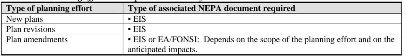
The level of environmental analysis differs by the type of planning effort, as shown in Table III-1.
Table III-1.—Planning efforts and required NEPA analysis
Type of planning effort Type of associated NEPA document required
New plans ▪ EIS
Plan revisions ▪ EIS
Plan amendments ▪ EIS or EA/FONSI: Depends on the scope of the planning effort and on the anticipated impacts.
A. Planning for Environmental Impact Statement-level Efforts
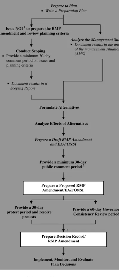
Figure 1 shows required planning steps for EIS-level planning efforts, followed by a description of each step.
Figure 1.—EIS-level planning efforts: Required steps for new plans, revisions, and amendments
3
Issue NOI1 to prepare the RMP(amendment)/EIS and
start scoping Management Situation Analyze the
▪Document results in an analysis of the management situation (AMS)
Conduct Scoping
▪Provide a minimum 30-day comment period on issues and planning criteria
▪Document results in a scoping report
Prepare a Draft RMP (Amendment)/Draft EIS
Formulate Alternatives
Analyze Effects of Alternatives
Publish NOA1 & provide a 90+-day public comment period
Publish NOA1, provide a 30-day protest period, and resolve protests
Provide a 60-day Governor’s Consistency Review period2
NOTES
1) The chart shows minimum planning requirements according to law, regulation, or BLM policy. BLM managers can go beyond these requirements as needed or desired.
2) Boxes around steps indicate required documents.
3) Inventory of resource extent and condition should occur as needed, but is most useful prior to the analysis of the
management situation.
Abbreviations:
EIS ~ Environmental Impact Statement
NOI ~ Notice of Intent
NOA ~ Notice of Availability
RMP ~ Resource Management Plan
1
BLM must publish a notice in the Federal Register.
2 States can negotiate a shorter
review period with the Governor.
3 If changes are significant, issue a
notice of significant change and provide a 30-day comment period.
Implement, Monitor, and Evaluate Plan Decisions Select a Preferred Alternative
Prepare to Plan
▪ Write a preparation plan
Prepare Record of Decision/Approved RMP (Amendment)
Prepare a Proposed RMP (Amendment)/Final EIS
1. Prepare to plan
The preparation plan is more than merely a vehicle to secure planning funds. A properly prepared preparation plan provides the foundation for the entire planning process by identifying the preliminary issues to be addressed, the skills needed to address them, a preliminary budget that can be used for the cost estimate, preliminary planning criteria, and data and metadata available and needed. If the plan is to be contracted, the preparation plan also forms the basis for the statement of work. Offices should use a full interdisciplinary team to develop a realistic preparation plan. If the plan is to be contracted, include the procurement staff on the
interdisciplinary team.
It is important that the preparation plans use the principles of project management and address the findings in the existing plan evaluation. A comprehensive preparation plan provides management direction, oversight, structure, cost estimate, and focus for the planning process.
Preparation plans should be as brief and concise as possible.
PRODUCT: PREPARATION PLAN—Appendix F-1 (Recommended Format for Preparation Plans) contains a more detailed outline and discussion of specific components for a preparation plan.
2. Issue a notice of intent to prepare the RMP (amendment)/EIS and start scoping
At the earliest opportunity, the BLM should notify the public, Indian Tribes, other Federal agencies, and state and local governments about its intent to engage in land use planning for a given area. BLM managers should take whatever measures they feel necessary to ensure all interested parties are notified of upcoming planning actions. At a minimum, however, the BLM must distribute two types of notices.
a. Publish a notice of intent (NOI) in the Federal Register. The BLM must publish a NOI in the Federal Register prior to scoping to announce its decision to prepare an EIS (and associated planning document) (40 CFR 1501.7). The NOI should identify
preliminary issues and planning criteria (see the following Conduct Scoping section).
b. Distribute scoping notices. Simultaneously with the Federal Register NOI, the BLM should submit a scoping notice to Federal agencies, state agencies, the heads of county boards, other local government units, and Tribal chairmen or Alaska Native leaders and any other entities/individuals who have requested such notice or the Field Manager has reason to believe would be concerned with the planning effort (43 CFR 1610.3-1(d)). BLM should request the current status of government entities’ officially approved or adopted resource-related plans, and the policies and programs contained therein.
Publication of the NOI in the Federal Register formally initiates the plan development, revision, or amendment process and begins the scoping process. Information discussions with cooperators (or potential cooperators), RACs, Tribes and other groups may occur before formal scoping begins.
3. Conduct scoping
Scoping is a requirement of both the NEPA regulations (40 CFR 1501.7) and the BLM planning regulations (43 CFR 1610.2 and 43 CFR 1610.4-1). The land use planning process is issue-driven. Scoping is a collaborative public involvement process to identify planning issues to be addressed in the planning process. Planning issues are disputes or controversies about existing and potential land and resource allocations, levels of resource use, production, and related management practices. Issues include resource use, development, and protection opportunities for consideration in the preparation of the RMP. These issues may stem from new information or changed circumstances, and the need to reassess the appropriate mix of allowable uses. Planning issues are addressed in and provide major focus for the development of alternatives (see Section III(A)(5), Formulate alternatives).
Scoping also involves the introduction of preliminary planning criteria to the public for
comment. Planning criteria guide development of the plan by helping define the decision space (or the “sideboards” that define the scope of the planning effort); they are generally based upon applicable laws, Director and State Director guidance, and the results of public and governmental participation (43 CFR 1610.4-2). Examples of planning criteria include but are not limited to the following:
a. The plan will be completed in compliance with FLPMA, NEPA, and all other relevant Federal law, Executive orders, and management policies of the BLM;
b. where existing planning decisions are still valid, those decisions may remain unchanged and be incorporated into the new RMP (or amendment);
c. the plans will recognize valid existing rights; and
d. Native American Tribal consultations will be conducted in accordance with policy and Tribal concerns will be given due consideration. The planning process will include the consideration of any impacts on Indian trust assets.
PRODUCT: SCOPING REPORT—The BLM must document the results of scoping (43 CFR 1610.2(d)). Field offices must either write a scoping report to capture public input in one
document (recommended), or include the results of scoping in the Analysis of the Management Situation (AMS) (see following Section III(A)(4)). The documentation must summarize the individual comments received during the formal scoping period of the planning process. It must also describe the issues and management concerns from public scoping meetings, internal
scoping meetings, and those included in the preparation plan. See Appendix F-2 (Recommended Format for Scoping Reports).
4. Analyze the management situation
The BLM must analyze available inventory data and other information to characterize the resource area profile, portray the existing management situation, and identify management opportunities to respond to identified issues. This analysis provides, consistent with multiple use
principles, the basis for formulating reasonable alternatives, including the types of resources for development or protection (43 CFR 1610.4-4).
The analysis should (as briefly and concisely as possible) describe the current conditions and trends of the resources and the uses/activities in the planning area to provide information for the affected environment, provide the basis for the no action/present management alternative, and to create a framework from which to resolve the planning issues through the development of alternatives. The analysis should describe the status, or present characteristics and condition of the public land; the status of physical and biological processes that affect ecosystem function; the condition of individual components such as soil, water, vegetation, and wildlife habitat; and the relative value and scarcity of the resources. The analysis should also address social and
economic conditions that influence how people, communities, and economies interact with the ecosystem. Appendix D provides additional detail on addressing social science and economic considerations in the land use planning process in the context of the larger landscape.
PRODUCT: ANALYSIS OF THE MANAGEMENT SITUATION—Field offices should produce a report called the analysis of the management situation (AMS). Field offices are
encouraged to make a summary of the AMS findings (or the entire report) available to the public. Parts of the AMS should easily translate into the introduction chapter, the no action and action alternatives, and the affected environment chapter of the EIS.
Formulation of the AMS can begin as soon as the planning project is approved. Documentation supporting the AMS should be maintained in the field office for public review. The AMS document can be made available to the public during or after scoping. The scoping report can also be included in a published summary of the AMS if desired. See Appendix F-3 (Annotated Outline of the Analysis of the Management Situation) for additional guidance.
5. Formulate alternatives
Considering a reasonable range of alternatives helps the BLM and its partners understand the various ways of addressing the planning issues and different scenarios for management of the resources and uses in the planning area. Development of alternatives should draw on the management opportunities identified in the AMS. Each alternative includes desired outcomes (goals and objectives), and the allowable uses and actions anticipated to achieve those outcomes. It is important to keep in mind the following about alternative formulation:
a. The BLM must consider all reasonable alternatives, including the no action alternative (the continuation of present levels or systems of resource use). Some alternatives,
including the no action alternative, may be developed for detailed study, while others are considered but not analyzed in detail. Both types of alternatives are described in the RMP/EIS. Rationale should be briefly described to document why certain alternatives were not studied in detail (43 CFR 1610.4-5). An example may be that one alternative is a reasonable variation of an existing alternative analyzed in detail.
b. Reasonable alternatives analyzed in detail meet the purpose and need of the project and can be feasibly carried out based on estimated cost, logistics, technology, and social,
and environmental factors. An alternative may be considered reasonable even if it is outside the legal jurisdiction of the BLM because it may serve as the basis for modifying congressional approval in light of the analysis (40 CFR 1502.14(c); Forty Questions No. 2(b)).
c. Each fully-developed alternative represents a different land use plan that addresses and/or resolves the identified planning issues in different ways.
d. Each alternative will include a different suite of potential planning decisions to
address the issues. Some potential planning decisions may be common to multiple, or all alternatives.
e. Goals typically pertain to all alternatives (will not vary by alternative). Objectives, allowable uses, and management actions may (1) be consistent across alternatives, and/or (2) vary by alternative. A plan could include some objectives that vary by alternative, and other objectives that are consistent across alternatives.
f. Goals typically apply to the entire planning area. Objectives, allowable uses, and management actions may (1) apply to the planning area as a whole, and/or (2) be specific to certain geographic areas, such as those listed below:
1. Landscape-level systems (such as ecosystems and watersheds);
2. specific resources (such as threatened and endangered species and cultural sites);
3. areas (such as allotments and special management units); and
4. areas needing restoration or maintenance in order to meet land health standards.
g. All components of an individual alternative must be complementary. Desired
outcomes, allowable uses, and management actions can (and probably will) conflict from one alternative to the next. However, they must not conflict within any one alternative. For example, an alternative should not allow all lands open to oil and gas leasing while having all lands designated as Visual Resource Management Class I or II.
h. When identifying allowable uses in alternatives, consider resource development potential, levels of use, and restrictions to best achieve the identified goals and objectives (see Analysis of the Management Situation above). These uses and restrictions are based on resource protection needs and social and economic factors, and represent the most appropriate mix of uses and protections for the resources in the planning area. Different protection and restoration measures and the availability of areas for certain uses, levels of uses, and restrictions are presented in alternatives.
i. In developing alternatives, the BLM must consider the relative scarcity of the values involved and the availability of alternative means and sites for realizing those values (43 U.S.C. 1712(c)(6)).
j. Alternatives should be developed in an open, collaborative manner, to the extent possible.
6. Analyze the effects of alternatives
The BLM must estimate and describe the physical, biological, economic, and social effects of implementing each alternative considered in detail, including the no action alternative (43 CFR 1610.4-6). This analysis should provide adequate information to evaluate the direct, indirect, and cumulative impacts of each alternative in order to determine the best mix of potential planning decisions to achieve the identified goals and objectives (the analysis should also specifically address the attainment, or non-attainment, of Land Health Standards expressed as goals). The assumptions and timeframes used for analysis purposes (such as reasonably
foreseeable development scenarios) should be documented. The effects are described in the draft RMP (amendment)/draft EIS (see Section 8).
7. Select a preferred alternative
By evaluating the alternatives in the EIS, the BLM must determine which combination of potential planning decisions contained in the alternatives best meets multiple use and sustained yield mandates of Section 103(c) of FLPMA (43 U.S.C. 1702(c)). If any one alternative contains the desired combination of potential planning decisions, then that alternative should be identified as the preferred alternative. If the combination of potential planning decisions is drawn from different alternatives, then those potential planning decisions should be compiled into a new alternative (identified as the preferred alternative) and the impacts analyzed accordingly.
The preferred alternative should:
a. Meet statutory requirements;
b. represent the best combination of decisions to achieve the goals and policies of the BLM as reflected through the DOI’s Strategic Plan and State Director guidance; and
c. best respond to the purpose and need and best resolve the issues pertinent to the planning effort.
These and other agreed-to selection criteria should be used in selecting the preferred alternative. Development of criteria and evaluation of alternatives should include the involvement of RACs, cooperators, and interested members of the public to the extent practical. The final decision to select a preferred alternative, however, remains the exclusive responsibility of the BLM.
The Field Manager recommends the preferred alternative to the State Director. The State Director approves the selection of the preferred alternative along with the other alternatives under consideration.
8. Prepare a draft RMP (amendment) and draft EIS
PRODUCT: DRAFT RMP (AMENDMENT)/DRAFT EIS—This document describes the purpose and need for the plan, the affected environment, the alternatives for managing public lands within the planning area (including the preferred alternative), the environmental impacts of those alternatives, and the consultation and coordination in which the BLM engaged in
developing the plan. See Appendix F-4 (Annotated Outline for a Draft and Final RMP [Amendment]/EIS).
9. Publish a notice of availability and provide a public comment period
The BLM must provide at least 90 days for the public to comment on the draft RMP
(amendment) and draft EIS. This public comment period officially starts with the Environmental Protection Agency’s (EPA’s) publication of a NOA for the document in the Federal Register (43 CFR 1610.2(e)). The BLM also publishes a NOA in the Federal Register to provide information not contained in the EPA’s NOA about the project, comment period, contact information, and other supplemental information. The BLM may also announce the start of the comment period (and the dates, times, and locations of public meetings) through other mechanisms, such as press releases, planning bulletins or newsletters, direct mailings and e-mailings, and Internet postings.
Public comments may be submitted in a variety of forms, including written, electronic, and oral. The BLM must assess and consider all comments received (similar or “like” comments may be grouped for analysis). The BLM responds to public comments by one of the following ways (40 CFR 1503.4):
a. Modifying alternatives, including the proposed plan;
b. developing and evaluating alternatives not previously given serious consideration;
c. supplementing, improving, or modifying analysis;
d. making factual corrections; and
e. explaining why comments do not warrant further response, citing the sources, authorities, or reasons that support the agency’s position, and, if appropriate, indicate those circumstances that would trigger reappraisal or further response.
Although the BLM is not required to write to individual commenters to explain how their comments were addressed, it is required to respond to substantive comments and include the response in the proposed RMP (amendment) and final EIS. Nonsubstantive comments are those that include opinions, assertions, and unsubstantiated claims. Substantive comments are those