Use of Ashtech MobileMapper GNSS system in forestry applications
Gabriele GARNERO
1, Giorgio CARESIO
2,
1
Università degli Studi e Politecnico di Torino
DIST - Dipartimento Interateneo di Scienze, Progetto e Politiche del Territorio Torino - Italy
2
GMX Positioning s.r.l., Torino - Italy
Abstract
In the continuously developing GIS market, forestry applications and, in general, no-geodetic users poses more demanding requirements.
Customers are primarily asking for better accuracy: in network management applications (water distribution, telecommunications or electricity, …), sub-meter accuracy is just not enough.
Extended position availability is also becoming a strong requirement: being unable to run GIS projects in obstructed areas because of a lack of reliable positions due to adverse reception conditions is simply unacceptable.
In parallel, as the number of specific GIS applications increases, customers are asking for more processing power, higher-quality screens and truly “handheld-operated” receivers.
In 2012 Ashtech® introduced the MobileMapper® 120 to give the answer to all these requirements (Ashtech, 2013).
The MobileMapper 120 comes in a lightweight, compact, ruggedized, Windows® Mobile handheld platform.
It is fitted with a powerful processor, a large full daylight-compatible color touch screen, a cellular modem and Bluetooth connection.
Moreover, this instrument offers an high level of accuracy using its internal antenna.
This paper details the level of accuracy that can be expected from the MobileMapper 120 in various situations, specifically in forestry (Breshears et al., 2005; Shaw, 2005, Ghosh et al, 2012).
Keywords:
Forestry measurements, GIS survey, GNSS, GNSS accuracy1. Introduction
In many specific GIS market segments, there is a growing need for more accuracy (Minucciani and Garnero, 2013; Chiabrando et al., 2011; Guarín, 2005).
One way of meeting this requirement is to offer post-processing capabilities.
However, more and more users want the required level of accuracy to be available right in the field, that is, in real time. This technically requires implementing professional GNSS (Global Navigation Satellite System) technologies together with adequate connectivity.
Several companies have also been working on solving the many
while optimizing performance and keeping the platform a truly “handheld” product for field use?
The MobileMapper 120 is one of this product, combining an internal high-grade GNSS antenna with powerful processing capabilities.
The result is that the receiver can achieve good accuracy with its internal antenna, from meter down to centimeter level, depending on configuration and environment.
With this technology, meter accuracy is achieved in standalone mode, sub-meter accuracy in SBAS DGPS and decimeter accuracy in Flying RTK using corrections from a single base or a base network (Pirotti et al., 2013; Pirotti et al., 2012).
For short baselines, the receiver can ultimately provide centimeter-level accuracy in open sky, with high availability.
2. Basics of GNSS Positioning
Generally the signals of four satellites have to be received by a GNSS receiver to solve for the three coordinates and the receiver clock error: If only one receiver is used, one talks about absolute positioning leading to positioning accuracies of about 10 m. The reason for this limited accuracy are different error sources like: satellite orbit and clock errors, ionospheric and tropospheric delays as well as multipath effects (Tab. 1).
Tab. 1: Inherent GPS Error Sources and their Magnitudes
Stand-alone
(hand-held)
GNSS
[m]
DGPS
[m]
Satellite
Clocks
3.0 0.0
Orbit Errors
2.7 0.0
Ionosphere
8.2 0.4
Troposphere
1.8 0.2
Receiver
Noise
0.3 0.3
Multipath
0.6 0.6
User
equivalent
One possibility to increase the accuracy is the computation of a position with respect to a second receiver due to the fact that most of the error sources are eliminated or reduced to a large extend because of the almost identical ray paths of the signals from each satellite to the two receivers.
This relative position may be computed in real-time or in post-processing mode: in the first case corrections of the second receiver are transmitted via wireless broadcast or mobile phones to the first receiver. The first receiver uses the information for the estimation of the relative position.
In the second case the raw data of two or more receivers is stored during the measurements and the relative position is estimated in the office. The later has the advantage of a more reliable and accurate positioning; the first of the availability in the field. The real-time solution is called Differential GPS (DGPS). The accuracy using correction data delivered by an own reference receiver, a DGPS service or WAAS/EGNOS signals may be specified to approximately 1 to 5 m.
The positioning methods mentioned up to now are generally used to fulfill the needs of military and navigation users; geodetic positioning and geo data acquisition generally requires higher accuracies. For these purposes the carrier phases of the GPS signals are used for relative positioning.
For GIS GNSS receivers used for geo data acquisition generally carrier-phase-smoothed code data is used for positioning: this means that the more accurate phase signal is used to increase the quality of the code signal.
One may obtain coordinates with an accuracy between 0.5 and 3 m. All accuracy information is valid for civil users that utilize the C/A – code of the GPS system. Military users, that have access to the P-code, have the possibility to reach a higher accuracy.
For precise geodetic positioning the carrier signal is used directly: since the wavelength of the carrier waves are around 20 cm and unambiguous positioning is not possible. The solution for the ambiguities is the main task for precise positioning.
The relative position may be determined with an accuracy of some cm up to the mm level, if the observations last
some
hours. These accuracies are attainable also for continental dimensions. If the precise positioning is carried through in real-time using corrections the accuracy may be estimated around 1 – 5 cm for static positioning.For a moving receiver (in other words: kinematic positioning) the accuracy is specified by approximately 10 cm due to problems in ambiguity fixing and due to the fact that one has only one position for each epoch at his disposal.
Independent of the kinematic or static modus this technique is called Precise Differential GPS (PDGPS) or Real-Time Kinematic (RTK): generally this relative positioning using the phase signal is referred to as precise positioning, independently of the real-time or post-processed availability of the solution (Tab. 2).
Tab. 2: Accuracy potential of different GNSS positioning modes
Absolute
Relative
Real-time Post
Processing
Code
signal
10 m
1-10 m
1-5 m
Carrier
signal
- Static:
0.01-0.05
m
Kinematic:
0.10 m
Static:
0.001-0.02
m
Kinematic:
0.01-0.10
m
Different application scenarios and different accuracy levels require different receiver classes.
They are separable by their technical possibilities, their accuracy level and their fields of application.
For more detailed information about GPS one is referred to textbooks like Biagi (2009).
3. The Technical characteristics of the
MobileMapper 120
The MobileMapper 120 is a Windows 6.5–based field computer with a highly sensitive internal GNSS antenna and Ashtech’s proprietary Z-BLADE technology, which allows the MobileMapper 120 to receive and process different GNSS signals: the US GPS and Russian GLONASS constellations, as well as SBAS (Satellite-Based Augmentation System) satellites, such as those of the Wide Area Augmentation System (WAAS), which is operated by the US Federal Aviation Administration and also the corresponding European system EGNOS.
The MobileMapper 120 is a full-function field computer: it comes with Microsoft Office Mobile software suite (Word, Excel, and PowerPoint). With a wireless network connection, you can send/receive e-mail or surf the Web using Internet Explorer. With cell phone service, you can also make calls. The MobileMapper 120 can run a wide variety of software, such as ESRI’s ArcPad or Ashtech’s MobileMapper Field. It can use Bluetooth for communications with other devices, such as laser rangefinders, and transfer shape files, imagery, and other data via a USB port in the MobileMapper 120’s docking station, which doubles as a recharger for the unit’s lithium-ion battery. The MobileMapper 120 comes with a 2 GB flash memory “disk” and a Secure Digital (SD) card slot for adding storage.
Fig. 1: the MobileMapper 120 monitor
Designing a handheld receiver capable of delivering decimetric, and even centimetric accuracy, from its sole internal antenna implies that every effort is made to overcome the inevitable degradation of the GNSS (GPS and GLONASS) signal received (Fig. 2).
Fig. 2: different screenshot of the receiver
4. Testing the GNSS Performance of
MobileMapper 120
The main factors that are responsible for signal degradation are listed below:
Internal interference. Embedded electronic devices, such as GSM and BlueTooth, are an additional source of noise and interference for the GNSS signal received;
Errors & biases due to multipaths. Embedding a GNSS antenna into a handheld receiver has a strong impact on the dimensions the antenna may have. The direct consequence of a smaller antenna is a higher level of errors and biases due to multipaths;
Obstruction due to human body. Truly “handheld” use of the receiver means the internal antenna is used very close to the operator’s body, potentially resulting in more satellites masked and more reflected signals observed at the antenna input.
GNSS performance is a critical aspect in GIS handheld receivers. If designed around consumer-based GPS chips, receivers cannot be ranked as high-end GIS products. Only the use of professional-grade GNSS technology can actually make a difference.
The best way to highlight a GNSS receiver capability to better track satellites and come up with more accurate positions is to test it in adverse reception conditions. Being able to operate smoothly in those conditions is key for GIS data collection, and even more important when higher levels of accuracy are needed. This paper presents a thorough assessment of the GNSS performance of the MobileMapper 120 through two different categories of tests. The receiver was tested individually with its internal antenna in different reception configurations (Edson and Wing, 2012; Ordoñez, 2012):
1. Position computation, static occupation, open sky: - GPS only + SBAS
- GPS + GLONASS + SBAS
2. Area & perimeter computation, kinematic, open sky: - GPS only + SBAS
- GPS + GLONASS + SBAS
- GPS + SBAS DGPS (RTCM 2.3 corrections)
Different tests were performed to test the operation under leaf coverage (heavy canopy).
All the tests were conducted in real time with MobileMapper 120 run by Ashtech field software Mobile-Mapper Field, supplied by GMX Positioning s.r.l., the Spectra Precision Local Dealer . Test are performed in Grugliasco (TO), near the Universitary Campus, and in the woods in Val Maira valley (CN).
4.1 Static tests
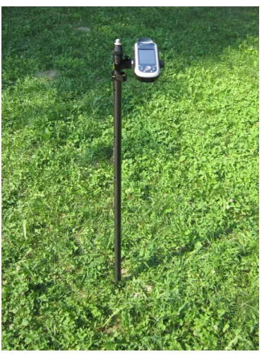
The receiver was mounted on a tripod and operated in a widely open area (no obstructions nearby; Fig. 3):
internal antenna used (Fig. 4);
overall test duration: > 4 hours;
position computation reset every 5 minutes (more than 100 iterations);
position collected unconditionally at three different times following receiver reset: at reset time (0 sec), 30 sec. after reset, and 60 sec. after reset;
Tab. 3: RMS for the different tests
Time of
collection
GPS only + SBAS
GPS + GLONASS
+ SBAS
Horz.
Error
(RMS)
[m]
Vert.
Error
(RMS)
[m]
Horz.
Error
(RMS)
[m]
Vert.
Error
(RMS)
[m]
+0
s 0.75 1.35 0.92 1.34
+ 30 s
0.60
0.96
0.58
0.96
+60
s 0.61 0.97 0.55 0.90
We can draw the following considerations:
MobileMapper 120 is consistently sub-meter accurate;
in open sky conditions, GLONASS has a neutral effect on accuracy.
Fig. 3. Test Site
Fig. 4. Receiver Setup
4.2 Area & Perimeter Measurements
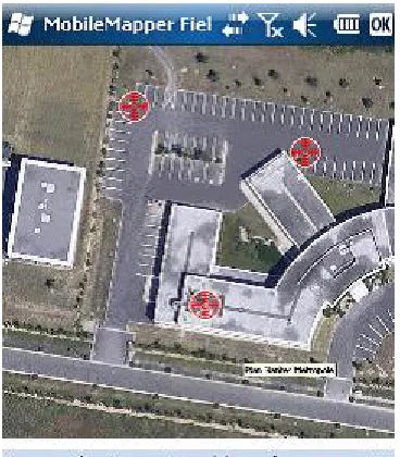
The receiver was mounted on a half-pole and operated to measure the area and perimeter of a football court (virtually open sky conditions; see Fig. 5):
internal antenna used;
measured areas and perimeters compared to “true” values determined after post-processing field data collected with ProMark 800;
area and perimeter measured 10 times;
operator uses Ashtech MobileMapper Field software to log the limits of the court as an area feature (in automatic mode);
raw data also logged for post-processing. Raw data postprocessed with Ashtech MobileMapper Office software;
Fig. 5: test site, panoramic view
Tab. 4: Area & Perimeter Measurements
GPS only + SBAS
GPS + GLONASS +
SBAS
Perimeter
2.75 m
1.80 m
Area
6.10 m
21.35
m
24.3 Testing Flying RTK
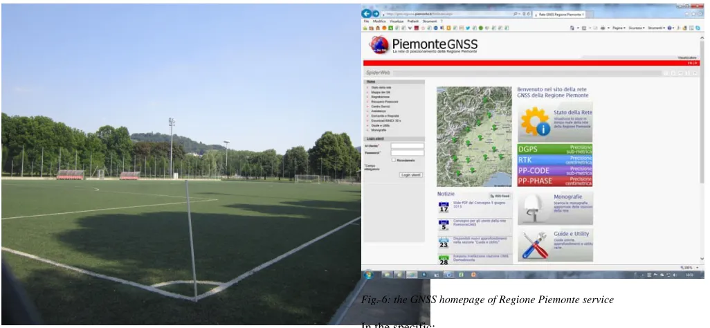
Two MobileMapper 120 are used side by side to collect the same GIS data: one is used in Flying RTK, receiving corrections via its internal modem from a base about 100 km (Master Station Politecnico di Torino) apart, the other in conventional SBAS DGPS mode.
The system has also been used in the network of permanent GNSS stations of the Piedmont Region, activating the cellular data communication to which the receiver is supplied with and using the Network Mount Points for DGPS and RTK corrections (Fig. 6).
Fig. 6: the GNSS homepage of Regione Piemonte service
In the specific:
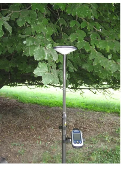
a large amount of point features are logged in various environments (urban areas, shady parks, heavy canopy, etc.) in order to have the two receivers operated in real conditions of use where satellite reception may be impaired by multipaths and obstructions (Fig. 7);
both units use their internal antenna;
point features are logged with Ashtech MobileMapper Field
software in both units (Tab. 5).
Tab. 5: Testing Flying RTK
Position
Error
H_RMS [m]
Position Error
V_RMS [m]
GPS +
SBASr
0.95 1.52
Flying
RTK
0.32 1.10
Fig 7: heavy canopy test
These results prove that, in real conditions of use, the MobileMapper 120 can achieve better than 0.5 meter horizontal accuracy in Flying RTK over long baselines.
MobileMapper 120 users can consider implementing accurate GIS applications with a single base station covering a fairly large region or, better, using a network of permanent GNSS stations.
4.3 Acquisition in forestry field
The test was performed in the Val Maira, in a stand with an overstory of beeches, firs and larch.
The location of each point is known to within 2 centimeters. In two circuits of the 13-15 point course, we have recorded errors ranging from 0.55 meters to 3.68 meters. The average error using EGNOS (no post-processing operation ) was just 2.23 meters. We also used the receiver to map a 14 hectares parcel under light to moderate canopy cover.
During the traverse, the receiver reported receiving signals from a minimum of 11 and a maximum of 15 satellites, including the EGNOS satellite, and position dilution of precision (PDOP) values ranging from 1.7 to 3.6 (excellent).
5. Conclusions
In view of the test results obtained, MobileMapper 120 appears as a useful product offering good benefit when:
excellent accuracy is required;
reception conditions are difficult;
truly “handheld” operation is needed.
Acknowledgments
The experiment was performed using tools provided by GMX Positioning s.r.l. – Torino (Italy).
References
Ashtech White Paper: MobileMapper™: a Breakthrough in Handheld Accuracy, [online July 2013]
http://www.spectraprecision.com/products/gis-mobile-mapping/mobilemapper-120-product-brochure-20663.kjsp Breshears, D.D.; Cobb, N.S.; Rich, P.M.; Price, K.P.; Allen,
C.D.; Balice, R.G.; Romme, W.H.; Kastens, J.H.; Floyd, M.L.; Belnap, J.; Anderson, J.J.; Myers, O.B.; Meyer, C.W. (2005): Regional Vegetation Die-Off in Response to Global-Change-Type Drought, Proceedings of the National Academy of Sciences. 102, 15144–15148.
Biagi, L. (2009): I fondamentali del GPS, on line at http://geomatica.como.polimi.it/workbooks
Chiabrando, R.; Fabrizio, E.; Garnero, G. (2011): On the applicability of the visual impact assessment OAISPP tool to photovoltaic plants, Renewable and Sustainable Energy Reviews, 15 (1), pp. 845-850, DOI:
10.1016/j.rser.2010.09.030
Edson, C.; Wing, M.G. (2012): Tree location measurement accuracy with a mapping-grade GPS receiver under forest canopy, Forest Science, Volume 58, Number 6, 16 December 2012 , pp. 567-576(10)
Guarín, A.; Taylor, A.H; (2005) Forest Ecology and Management 257, 1353–1362.
Ghosh, J. K., Bhattacharya, D., Samadhiya, N. K., Boccardo, P. (2012): A generalized geo-hazard warning system, Natural Hazards, 64(2), 1273-1289
Minucciani, V.; Garnero, G.: Available and Implementable Technologies for Virtual Tourism: a Prototypal Station Project, in B. Murgante et al. (Eds.): ICCSA 2013, Part IV, published in Lecture Notes in Computer Science LNCS 7974 (ISSN: 0302-9743), pp. 193--204. Springer, Heidelberg (2013) [DOI: 10.1007/978-3-642-39649-6-14]
Ordoñez, C.; Martínez, J.; De Cos Juez, J.F.; Lasheras, F.S. (2012): Comparison of GPS observations made in a forestry setting using functional data analysis, International Journal of Computer Mathematics, Volume 89, Issue 3
Pirotti, F.; Guarnieri, A.; Vettore, A. (2013): Ground filtering and vegetation mapping using multi-return terrestrial laser scanning, ISPRS Journal of Photogrammetry and Remote Sensing, 76, pp. 56-63.
Pirotti, F.; Grigolato, S.; Lingua, E.; Sitzia, T.; Tarolli, P. (2012): Laser scanner applications in forest and environmental sciences, Italian Journal of Remote Sensing / Rivista Italiana di Telerilevamento, 44 (1), pp. 109-123.
Shaw, J.D.; Steed, B.E.; DeBlander, L.T. (2005): Forest Inventory and Analysis (FIA) Annual Inventory, Journal of Forestry, Volume 103, Number 6, September 2005 , pp. 280-285(6)
Gabriele Garnero Professor of Geomatic at Degree Courses in Forestry and Environmental Sciences at the University of Turin and in Planning Sciences at the Polytechnic of Turin.