METRO: An Ideal Solution for Traffic
Bismi P J, Maria Kurian
M.Tech Student, Dept. of CSE., ICET Muvattupuzha, Kerala, India
Assistant Professor, Dept. of CSE., ICET Muvattupuzha, Kerala, India
ABSTRACT: Metro is a mass rapid transportation system. It is convenient, efficient, reliable, fast, modern, user friendly, comfortable and affordable mode of urban transport. In this case study the importance is give to understand the benefits of new metro that can reduce the traffic congestion on roads. Metro rail system will help to eliminate the future bottlenecks in the existing road network by supporting traffic density reduction. The paper presents evaluation of metro in terms of capacity, travel time and accessibility to the system and evaluation indices reflecting commuter's perspective. The Metro rail system has proven to be most efficient in terms of energy consumption, space occupancy and numbers transported. The major advantage of this is their ability to move large numbers of people quickly. Heavy traffic congestion has necessitated the development of a metro rail system in Kochi. The new system will reduce traffic congestion, while providing safe and rapid transportation to commuters. It will also reduce pollution and noise levels, as well as congestion on city roads. Data collection is done from people who are lived in Kochi city. The collected data is analyzed and used for hypothesis testing. After the hypothesis testing conclusion is obtained.
KEYWORDS: Kochi metro, Traffic.
I. INTRODUCTION
Kochi Metro Rail project has been planned by Government of Kerala. Special Purpose Vehicle called Kochi Metro Rail Ltd. (KMRL) is formed for the implementation, operation and maintenance of the Metro Project. Around 25 km length metro line with 22 stations with Maintenance Depot at Muttom will be developed between Aluva to Petta. The Kochi Metro system is an urban Mass Rapid Transit System (MRTS) that is being built to serve Kochi, the commercial capital of Kerala. Construction for its 25.12 km Phase 1A from Aluva to Petta with 22 stations started in June 2013 and is expected to be completed in 2017. In 2014, a 1.92 km eastward extension to Tripunithura from Petta was approved to be included in Phase 1.Construction on it will begin once road widening along the route is completed. Phase 1B of the project includes a new spur line from Jawaharlal Nehru Stadium to Info Park II in Kakkanad.
The project was approved by the state government in May 2015 and construction work is expected to begin in 2017. The Metro Rail System has proven to be most efficient in terms of energy consumption, space occupancy and numbers transported. The major advantage of all these systems is their ability to move large numbers of people quickly. Obviously, the actual number of passengers moved will vary according to the frequency of the service and the number of coaches in each train. When the Docklands Light Railway was built it used units with a single articulation and ran at a 7-10 minute frequency. It has been extended several times and now serves over double the number of stations. It has also improved the frequency and now runs three twin cars coupled together. Heavy traffic congestion has necessitated the development of a metro rail system in Kochi. Buses are currently the major public transportation system in Kochi. The new metro system will reduce traffic congestion, while providing safe and rapid transportation to commuters. It will also reduce pollution and noise levels, as well as congestion on city roads. The project will create employment opportunities for the local people.
II. RELATED WORK
[1] Kochi, the commercial hub of Kerala, is already experiencing signs of urban growth pressures. As per World Bank, Kochi is recognized as one of the seventeen major industrial cities of India and an easy city to start business in India. This decade is witnessing huge investments in the region like International Container Transshipment Terminal at Vallarpadam, Info Park at Kakkanad, Special Economic Zone by NEST, LNG terminal, Electronic hardware park. Among the districts, Ernakulum district contributes the highest portion (14.47) of Kerala's GDP. Being a centre of excellence of education and a destination for major industries and establishments like High court, Stock exchange, Kochi shipyard, Spice board etc. attract significant floating population form the neighbouring districts for their livelihood. In addition to this, Kochi has been emerged as a major tourist destination to domestic as wells as international tourists. Recently opened mall by Lulu group has multi folded the number of visitors in the city. Urbanization has been observed as a new phenomenon with a quickening pace in the last 15 to 20 years. Kochi Corporation with a population of 602046 in 2011 (Census 2011) will grow at an annual growth rate of 1.0 during 2011-2031 (Development Plan for Kochi city region Draft (2011-2031)). Kochi city region comprising two municipalities and surrounding local bodies with an area of 369.72sq.km will carry a population of 22.73 lakhs by 2031(Development Plan for Kochi city region {Draft (2031)). Roughly 68 percentage of the population, compared to about only 48 percentage in 2001, lives in urban areas in the Ernakulum district which is far beyond the state average. The urban population in Ernakulam is presently estimated to increase 4.2 percentages annually.
[2] Rapid growth of India's urban population has put enormous strain on transport systems. The vehicle population in metropolitan cities is increasing tremendously in recent years leading to congestion in urban areas Construction of public transport facilities, especially Metro rail, Mono rail are under progress in many major cities. Handling traffic in work zones is a challenge because the work activity presents an abnormal and often disruptive environment to the motorist. Quantification of impact is essential. Work zones may reduce capacity; increase the travel time delays, queue length, fuel consumption, number of forced merges, and roadway accidents. It is essential that the existing traffic how pattern and change in pattern during construction period has to be studied in detail for better planning. To study the traffic characteristics and accident occurrence before and during work zone creation for construction purposes. To simulate traffic how on the formulated scenarios and evaluate their performance in terms of travel time and delay. Inefficient operation of traffic at work zone areas typically leads to increase in travel time delays, queue length, number of forced merges, and roadway accidents. GPS is an efficient tool in recording vehicle position and speed values. Planned lane closures in work zone can accelerate work operations, reducing the duration of impacts to road users. Microscopic simulation software is the important tools to assess the impact of work zones. It is essential that the existing traffic flow pattern and change in pattern during construction period and their impact on traffic for different traffic conditions.
III.METHODOLOGY
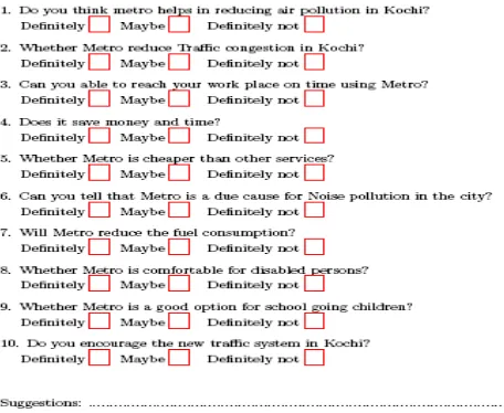
Figure 1: Questionnaire
IV.ANALYSIS AND RESULTS
After collection, the data has to be processed and analysed in accordance with the outline laid down for the purpose at the time of developing the research plan. Data processing includes editing, coding, classification and tabulation of data. Analysis, particularly in case of survey or experimental data, involves estimating the values of unknown parameters of the population and testing of hypotheses for drawing inferences. Analysis of data collected by the questionnaire shows that the respondents were happy to participate in the case study and almost all of them answered all the questions. The survey details are shown in the Table 1 as percentage. In below table contain a Column Q.No to represent the question number given in questionnaire.
Q. No Definitely (In %)
Maybe (In %)
Definitely not (In %)
1 55 29 16
2 68 17 15
3 52 28 20
4 43 38 19
5 49 33 18
6 39 20 41
7 31 40 29
8 53 29 18
9 38 49 13
10 45 43 12
Here Chi- square test is used for hypothesis testing. A chi-squared test can be used to attempt rejection of the null hypothesis that the data are independent. The chi- square test is always testing what scientists call the null hypothesis, which states that there is no significant difference between the expected and observed result.
The equation for Chi- square testing is given below:
Where,
Oij =observed frequency of the cell in ith row and jth column.
Eij =Expected frequency of the cell in ith row and jth column.
Here, testing of my hypothesis is going to be conducted. H0: Metro is not the competent way of reducing traffic system.
H1: Metro is the most competent way of reducing the ever growing traffic congestion of the developing city.
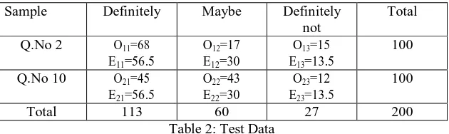
The questions 1 and 7 are used for Chi- square test. Contingency table prepared for Chi- square testing is show in below as Table 2.
Sample Definitely Maybe Definitely
not
Total
Q.No 2 O11=68
E11=56.5
O12=17
E12=30
O13=15
E13=13.5
100
Q.No 10 O21=45
E21=56.5
O22=43
E22=30
O23=12
E23=13.5
100
Total 113 60 27 200
Table 2: Test Data
And Chi- square values are calculated from this Table 2 is also given below:
Table 3: χ 2 values
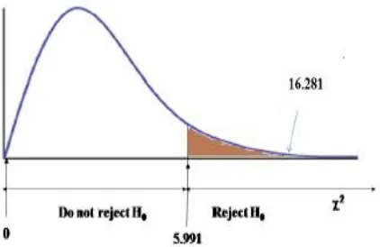
Here degree of freedom = (3-1) (2-1) =2
At 2 degree of freedom and 5 percentage level of significance, the critical value is 5.991 and calculated value is 16.28. The calculated value 16.28 much greater than critical value, so I am rejecting the H0 hypothesis, it states that the metro
is not the competent way of reducing traffic system. Therefore Accepting the H1 (alternative hypothesis): Metro is the
Figure 2: χ 2test with degree of freedom 2
V. CONCLUSION AND FUTURE WORK
From the case study I have reached the conclusion that the metro systems have been planned to reduce congestion on the roads. Even though the metro systems are more reliable, comfortable and safer than road based systems and it reduces traffic congestion on the roads, the system planned in Kochi show cost overrunning and under utilization of capacity. High capacity system does not necessarily generate high demand. Immense thought and planning is needed for such expensive and expansive project.
Metro rail system is the best way to decongest traffic. However, a number of considerations should be kept in mind in order to run a successful metro rail system. Viability of metro projects depend on correct denying of traffic corridors, technology adapted, availability of land, volume of traffic carried, capacity utilization and acceptance of the mode by commuters. Conclusively, transport need to be made an integral part of urban design/master plan of the city as it cannot be delineated to a separate entity. A multi model transportation system would ensure the use of metro rail to its best potential. The uncertainty of metro rail system, which has plagued the importance of such systems in India, seems to be resolving.
REFERENCES
[1] Bag, S. and Sen., S. S. (2012), Kolkata metro railway and customer satisfaction: An empirical study", International Journal of Multidisciplinary Research, vol. 2, pp 165-176.
[2] Beaumont, L. D. and Mills, G. (1999), urban light rail: intermodal competition or coordination?” Transport Reviews, vol. 19, pp. 241-253. [3] Pan, Q. (2012), The impacts of an urban light rail system on residential property values: a case study of the Houston METRO Rail transit line". [4] Sekar, S. P. and Karuppannan, S. (2012), Contributions of Metro Rail Projects in the Urban Dynamics of Indian Metro Cities: Case Study of Chennai and Bangalore", Proceedings of the 48th ISOCARP Congress, 2012.
[5] Anhita Mukherji, “Lives & the Metro”, The Times of India, 21 June 2012.
[6] Bhattacharjee, S. R. and Goetz, A. R. (2012) “Impact of light rail on traffic congestion in Denver” Journal of Transport Geography 22 (2012), pp. 262–270.
[7] Kapil Dave, “Metro Rail Bets on Wind Power to Run Its Trains”, The Indian Express, 17 June 2012. [8] http://tripp.iitd.ernet.in/delhibrts/metro/Metro/public20trpt20systm20-20review.pdf.