VALLEY SEDIMENTS AS EVIDENCE OF PREHISTORIC LAND-USE: A STUDY BASED ON DRY VALLEYS IN SOUTH FAST ENGLAND
Martin Bell
UNIVI:RSITY OF LONDON INSTITUTE OF
ARCHAEOLOGY LIBRARY
"
This thesis is submitted for the degree of Ph.D. at the
Institute of Archaeology, London University.
BEST COpy
.
"AVAILABLE
.
LAND-USE : A STUDY BASED ON DRY VALLEYS
IN SOUTH EAST ENGLAND
Martin Bell
Several recent studies have drawn attention to the existence
of substantial alluvial and colluvial valley fills which accumulated
over archaeological time.
These fills have been variously
associated with climatic change and anthropogenic effects.
In the
case of colluvial deposits on the English chalk their extent, nature
and cause was far from clear.
It was hoped that a detailed
investigation of the relationship between colluvial valley deposits
and prehistOric land-use on the South Downs would contribute to the
identification of causative factors and establish a methodology
which might be applied to the investigation of deposits elsewhere.
Three areas, all of them well known archaeologically, were
investigated in detail: Kiln Combe, near Eastbourne; Itford Bottom,
near Lewes; and Chalton, near Petersfield.
Ineach a trench was dug
across the valley floor and detailed drawings of the sediments made.
A strip was then hand excavated and all the artifacts were three
dimensionally recorded
inorder to date the deposits. The
environmental conditions under which they had accumulated were
studied by mollusc and sediment analysis.
Work
inthe study areas showed that colluvial deposits were
fairly widespread, contained large quantities of artifacts and
accumulated over a long period, largely as a result of land-use
factors. The existence of so much eroded sediment, containing an
important component of Pleistocene loess, seems to suggest that
some pedological changes have occurred during the Postglacial.
~
TABLE OF CONTENTS
1. The evidence for valley sediments and the factors which
produced them
(a) Introduction • • • • • •
(b) Mediterranean valley sediments • • • • •
(c) Valley sediments in Europe. • • •
(d) Alluvial sediments in the British Isles
(e) Colluvial sediments in the British Isles
(f) The chalk dry valleys. • •
(g) Colluvial deposits on chalk • •
(h) Colluvial deposits on limestone •
(i) Colluvial deposits on other bedrocks
(j) The extent of colluvial valley fills (k) Erosion processes on the chalk. •
(1) Other considerations •
2. The ecological history of the South Downs
(a) Geomorphology. • • • • •
(b) Pedology • • • • •
(c) Vegetation history •
(d) Molluscan studies •
(e) Land-use history •
• • • • • • • • • • • • • • • • •
(f) Outline of the main research problems. •
3.
Field and laboratory methodology(a) Field techniques • • • •
(b) Dating using artifacts • •
(c) Radiocarbon dating. •
•
• • •(d) Laboratory. anaJ.ysis • • • • • •
(e) Analysis of land molluscs • • • • • •
4.
Investigations in Kiln Combe, East Sussex(a) Geology and Geomorphology • • • • •
(b) Hydrology • • • • • •
( c) The archaeological background • • • (d) Kiln Combe dry valle,y • • • •
( e) The stratigraphic sequence • • • •
(f) Dating using artifacts • • • •
(g) Radiocarbon dating •
•
• •(h) Laboratory analysis • • • •
(i) Soil tests • • • • •
(j) Land molluscs. • •
(k) The Plant remains, identifications by Caroline Cartwright and Dr. Gordon Hillman • • •
(1) The Soil pits • • • • •
(m) Conclusions • • • • • •
5.
Investigations in Itford Bottom, East Sussex(a) Geology and geomorphology • • • • •
(b) Hydrology • • • •
(c) The archaeological background • • •
( d) Itford Bottom
dry
valley·
• • • (e) Trench A.
,.
(f) Trench B • • • • •
(g) The stratigraphic sequence • •
• • • • • • • • • • • • •
. (iii)
(iv)
(h) Radiocarbon dating
• • • • • •221
(i) Dating using artifacts
• • • • • •222
( j)
Laboratory analysis
• • • •245
(k)
Soil tests
• • • • •249
(1)
Mollusc analysis •
• • •256
(m) The small mammal faunas, by T.P.
0'
Connor, B.So.
•268
(n) Charcoals, by Joan Sheldon, B.Sc.
• •269
(0)
Conclusions
• • • • • • • •211
6.
Investigations in the Chal ton area, Hampshire
218
(a) Geology and geomorphology
• • •218
(b) Hydrology
• • • • • • • •286
(e)
The archaeological background
• • •288
( d) The Bascomb valley
• •293
(e) The stratigraphic sequence
• •296
(f) Dating using artifacts
• • • • •303
(g) Laboratory analysis
• • • •308
(h) Soil tests
• • • • •312
(i) Mollusc analysis •
• • •314
( j)
Tee soil pits
•318
(k)
Conclusions and problems from Trench a
• •321
(1)
The minor valley at Chal ton
• •324
(m) The stratigraphic sequence
• • •..
328
(n) Dating using artifacts
• • • • • •336
( 0)
The sample columns
• • • • •,359
(r) Simple soil tests • • •
( s) Mollusc analysis • • • •
..
•(t) The charcoals identified by Joan Sheldon, B.Sc. •
(u) The soil pits •
(v) Conclusions • • • • • •
7 •
.Qonclusions and synthe.sis(i) Valley sediments as sources of evidence about
(ii)
(iii)
(iv)
prehistoric land-use • •
The dating evidence and its reliability
The extent of colluvial deposits •
The cause and date of colluviation
•
(v) The effects of colluvial processes upon the
distribution of archaeological sites
(vi) Postglacial vegetational and pedological
changes on the South Downs • •
•
•
•
•
•
(vii) Responses by prehistoric communities to these
( viii)
soil changes • • • •
Soil erosion as a possible explanation for
some of the settlanent pattern changes on
the Chalk • • • • •
Acknowledganents • • • • •
•
•
•
Appendix 1. List of the main documented valley bottom
colluvial deposits in Britain • •
Appendix 2. Type list of artifacts • • •
Appendix
3.
List of diagnostic sherds by fabric typefrom the trench in Kiln Combe
(vi)
Appendix 4. List of diagnostic sherds by fabric type
.
from Itford Bottom, Trench B • • 440
A.ppendix
5.
List of diagnostic sherds by fabric typefrom Chalton, Trench.b • • • 444
1. 2.
5.
6.
7.
8.9·
10.
..
LIST OF FIGURES.
Schematic diagram to show the main
si tuations in which colluvial. deposits
aonsistentiy recur •
• • • • • •Distribution of the main valley bottom
colluvial deposits
inBritain, shown
against the major outcrops of Chalk and
Limestone.
The numbers refer to the
gazetteer of sites, Appendix 1.
•Sites relating to the ecological history of
the South DoVins. The valley bottom
colluvial deposits are numbered as
inAppendix 1 •
• • •Diagram to show the method of
three-dimensional. artifact recording •
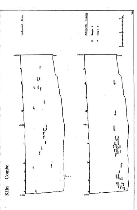
The geomorphology of the Bullock
Downarea
Archaeological sites
inthe Bullock
Downsurvey area (after Drewett 1977, Fig.8)
Long and cross-profile of Kiln Combe
showing soil pits a-c
• • • ••
•
•
•
The Kiln Combe valley trench in relation to
the Medieval settlement
• • •Long section of the valley deposits in
Kiln Combe.
• •The end wall of the Kiln Combe trench in
the valley centre
• • •11.
12.
13.
14.
15.
16.
17.
18.
19.
( viii)
Cul ti vation marks in the chalky layers
in Kiln Combe.
• • • •
•120
Kiln Combe. (a) Stratigraphic sequence
in hand excavated area. (b) Distribution
of Beaker pottery, Fabrics 81 and 51-60 •
127
Kiln Combe. (c) Distribution of flint
tools. (d) Distribution of flint flakes
Kiln Combe. (e) Distribution of Fabrics
51-60; 61; and 75 and in solid black
Iron Age Fabrics (f) Distribution of
Romano-British fabrics.
•
Kiln Combe. (g) Distribution of lledieval
Fabric 112. (h) Distribution of Medieval
Fabric 113
• • • •Kiln Combe. (i) Distribution of
•
carboni sed grain (j) Distribution of
charcoals identified and submitted for
radiocarbon dating •
• •
Kiln Combe. Decorated Beaker pottery, all
of Fabric 81. For details of decoration
see Appendix
3.
Scale 1:1.
•
•Kiln Combe.
Decorated Beaker pottery, all
of Fabric 81. For details of decoration
128
129
130
131
134
see Appendix 3. Scale 1: 1.
•
136
Kiln Combe.
Decorated Beaker pottery, all
20.
21.
22.
24.
25.
26.
21.
28.
29.
30.
is a gilded bronze fitting of Medieval
date. Scales all
1:1,
except1821 2:1
Particle size distribution of s&~ples
in Kiln Combe, Column 1 • • • • .
Particle size distribution of samples
in
Kiln
Combe, Column 2 • • • • Basic soil analysis data from samplesin Kiln Combe, Column 1 • • • Basic soil analysis data from samples
in Kiln Combe, Column 2 • •
Kiln Combe. Mollusc analysis of
Column 2 . • • • • •
Kiln Combe.
Column 1 •
Mollusc analysis of
• • • • •
•
•
Soil pits in Hod Combe (d) and Kiln
Combe (e) • • • • • •
•
•
•
•
The geomorphology of the Itford Botto~
area • • • • • •
The archaeology of the Itford Bottom
area • • • • • •
Lynchets and field monuments at the head
of Itford Bottom and on Itford Hill in
relation to the valley trenches. Based on
surveys by E. Holden and G.A. Holleyman
(ix)
138
152
153
166 168112
183
192
193
in
1949
and E.U. O'Shea in1918
• •
202
Long profile and cross-profile of Itford
Bottom dry valley. The depth and profile
31.
32.
33.
34.
35.36.
37.38.
39. 40.of Jones (1971) upriver and cannot
necessarily be taken as an accurate
statanent of the morphology of the
valley at this point • •
•
•Long section of Trench a. No analytical
work has so far been undertaken on
Mollusc Column
3
• • ••
•Itford Bottom, long section of Trench b
The section at the east end of Trench b
Diagram to illustrate the way in which
the artifact depth between 0 and 27m.
was corrected to take account of a
variable slope at right angles to the
line of the trench.. • •
Itford Bottom, the distribution of
-charcoals including those used for
radiocarbon dating • • • • •
Itford Bottom, the distribution of
artifacts of all types • • •
Itford Bottom, the distribution of
flint tools • • • • • •
Itford Bottom, the distribution of
flint waste • • • • • • •
Itford Bottom, the distribution of Bronze
Age pottery • • • • • • •
Itford Bottom, the Oistribution of
shelly wares •• • • • • • •
41.
42.
43.
44.
45.
46.
47.
48.
Itford Bottom, the distribution of
Iron Age pottery • • • • •
Itford Bottom, the distribution of
Romano-British pottery • • • •
Itford Bottom, the distribution of
Medieval and Post-Medieval pottery • •
Itford Bottom, the distribution of
Post-Medieval artifacts •
Itford Bottom, the distribution of
geological materials, marine molluscs
and metals • • • • • •
Particle siz~ analysis of Columns 1 and 2 from Itford Bottom. On the left are
the proportions of the larger fractions
in a 1kg. sample. In the centre are the
results of a sieve and sedimentation
analysis of a 40gm. sample of material
snaller than 2mm. (-1 ¢) • On the
right is a summary diagram showing the
fluctuating proportions of clay, silt
and sand in the 40gm. sample •
Graph of soil analytical data from
Columns 1 and 2 at Itford Bottom. The
two graphs overlap slightly in
strati-graphic .tems •
•
••
• •Itford Bottoo, mollusc analysis of
Column 2.
•
.
.,
. '
(xi) .
49.
50.
51.
52.
53.
54.
55.
56.
51.
58.
Itford 13'ottom, mollusc analysis of
Column 1 • • • • • • •
The geomorphology of the Chal ton area
The prehistoric and Romano-British
archaeology of the Chal ton area, (after
Cunliffe 1913, Figs.2-5) • • • •
The Anglo-Saxon and Medieval archaeology
of the Chalton area, (after Cunliffe
1913, Figs.
6
and 1) • • • • The long profile of the main Bascomb dryvalley, showing the sites of exposures of
(xii)
262
219
280
281
valley sediments and soil pits d and e 294
The cross-profile of the main Baacomb dry
valley showing soil pits h and i • •
Long section revealed by Trench a in
Bascomb, Chal ton • • •
(a) Sketch section of the subsoil hollow
in Trench a. (b) Sketch plan of Chalk
surface in hand excavated part of trench.
(c) Section of sediments in Havant Brook
295
291
valley (after White 1913, Fig.15)... 299
Chal ton, Trench a (i) Section of sediments
in excavated portion of trench. (ii)
Distribution of flint artifacts.
(iii) Distribution of prehistoric pottery ;04
Chal ton, Trench a (i v) Distribution of
Romano-British pottery (v and vi) Distribution
59.
60.
61.
62.
64.
66.
(xiii)
Particle size analysis of Chalton, Trench a.
On the left are the proportions of the
larger fractions
ina 1kg. sample.
In
the centre are the results of sieve and
sedimentation analysis of a 40gm. sample
of material smaller than
2mm. (-1¢). On
the right is a summary diagram showing the
fluctuating proportions of clay, silt and
sand
inthe 40gm. sample
•
• • •Graph of soil analytical data from Chal ton,
Trench a
• • ••
• • • •Chalton, Trench
~,mollusc analysis of
Column
3
•
• • • • •The long and cross-profiles of the minor
dryvalley which lies on the west edge of
Chalton village
• • • •Long section of the deposits in the very
minor
dryvalley at Chalton, revealed by
Trench b
• • •Chalton, Trench b. (a) Distribution of
flint flakes. (b) Distribution of flint
tools
• • ••
•
Chalton, Trench b. (c) Distribution of
•
•
•
charcoals. (d) Distribution of prehistoric
pottery of Fabrics 51 and 81
• •Chalton, Trench b. (e) Distribution of
prehistoric pottery, Fabrics 52 and 75.
(f) Distribution of Fabrics 61 and 82
, <
68.
10.
11.
12.
73.
Chalton, Trench b. (g) Distribution of
later Iron Age pottery fabrics.
(h) Distribution of Romano-British
fabrics • • • • • • • • Chalton, Trench b. (i) Distribution of
Fabric
110.
(j) Distribution of ~ateSaxon and early Medieval fabrics • •
Cha1ton, Trench b. (k) Distribution of
Medieval pottery, Fabrics
116
andRomano-British 2£ Medieval pottery,
Fabric
94/116.
(1) Distribution ofMedieval pottery of Fabrics
128-30
Chalton, Trench b. (m) Distribution of
Post-Medieval pottery. (n) Distribution
of Post-Medieval artifacts • • •
Chalton, Trench b. (0) Distribution of
b1ackfmi th' s debris. (p) Distribution
(xiv)
340
341
342
of metals, rocks and non-marine Mollusca
344
Chal ton, Trench b. Transparent sheet
showing the stratigraphy in the hand
excavated portion of the trench as an
overlay for the distribution drawings.
This is in a pocket at the back of
• • • • • •
Particle size analysis of Chalton,
Trench b. On the left, are the ,
.
-
' " 'back pocket
74.
75.
76.
77.
78.
a 1kg. sample.
Inthe centre are the'
resul ts of sieve and sedimentation
analysis of a 40gm. sample of material
smaller than
2mm. (-1¢).
On the right
is a
summarydiagram showing the fluctuating
proportions of clay, sil t and sand in the
40gm. sampl e
•
• • • •
•Graph of soil analytical data from
Chalton, Trench b •
• • • • • •Chal ton, Trench b, mollusc analysis
• •Contents of aestivation chambers (Samples
1 and 2) and earthworm burrows (Sample
3).
Histograms show the proportions of
particles (top axis) retained on sieves.
Broken lines show the number of mollusc
fragments (bottom axis)
ineach size
fraction.
• •
•
An
attempt to plot the approximate
dates at which colluviation was
initiated and was occurring. The sites
are numbered as on Fig.2 and Appendix 1
where bibliographical references are given.
The inset shows the distribution of sites.
An
attempt to plot the
a~proximatedates
at which the deposition of recent mineral
rich floodplain alluvium was initiated and
•
was occurring.
Bibliographical references
(xv)
376
397
79.
80.
,
Suggested relationship of soils on
downland topography to post-depositional
processes affecting the archaeological
record.
• •The chronology of Postglacial
environ-mental change on the Chalk of the South
Downs.
• • ••
•
. (Xvi)
408
I
I I
III
IV
V
VI
VII
VIII
LIST OF PLATES
Colluvial deposits in Itford Bottom, near
Lewes, East Sussex. The trenches were cut
across the valley at the point marked by a
star . . . . . . .
Air photograph of the dry valley beside
Cissbury Iron Age hill fort showing plateau
edge deposits round the head of the valley.
Note also the 'Celtic' fields, probably of
Romano-Briiish date, within the hillfort.
Photograph from Curwen (1929a, Plate XIV)
The Cuckmere valley, on the left a chalk
river cliff overlain by colluvium, on the
right thicker alluvium edge colluvial
deposits. On the slope above are Medieval
strip lynchets •
• •The Cuckmere valley, close-up of colluvial
deposits exposed by recent grazing and
(xvii)
•
21
•
•
25
visitor erosion at the edge of the alluvium
25
Seven Sisters, East Sussex, showing the
absence of colluvial deposits
inthe five
truncated
dryvalleys.
•
•
•
Three dimensional artifact recording in
progress at Chal ton
•
Periglacial stripes on Site 16, Bullock
Dovm, 1976.
•
•
•
•
•
• •
•
Silt pocket on Site 16, Bullock Dovm, 1976 •
41
80
IX
X
XI
XII
XIII
XIV
XV
XVI
Colluvial deposits at Cow Gap, Eastbourne
Air photograph showing grassland on the
south side of Kiln Combe with traces of,
largely undated, lynchets. The trench is
bottom right. Photo. by Mr. Tony Thompson
using a radio-controlled model aircraft •
Air photograph of the dry valley trench in
Kiln Combe. A patch of scrub to. the left
marks the hollow in which part of the
~
Medieval settlement lay. On the valley
side above this, the area of shadow marks
a colluvial bank on the edge of the
settlement. Photo. by Mr. Tony Thompson
using a radio-controlled model aircraft
The ,dry valley trench in Kiln Combe seen
from the north •
Composite photograph of west face of Kiln •
. (xviii)
101
107
114
114
Combe trench. Inset shows key to layers 116
The strata at the north end of the trench
in the valley centre •
Detail of the palaeosol l,ayers at the
base of the Postglacial strata in the
valley centre • •
.
~.
,Detail of the palaeosol layers taken at
a.
night,using ultra-violet reflectFlce.
Pan F film; 50 A~S.A.; 10 min. expo~ure;
F11 •
.
..
•.,
118
118
XVII
XVIII
XIX
xx
XXI XXIIXXIII
XXIVxxv
XXVI
The chalk layers in the 'upper and lower
buried soils' separated by a stone
accumulation horizon. Scale
6ocm.
• •'Upper buried soil' exposed in the hand
excavated portion of the trench •
••
The stratigraphy in the valley centre
and the lower buried soil under
excavation •
• • ••
• •Excavation of the Medieval settlement on
the floor of Kiln Combe over Easter 1979,
showing the valley sediments in plan
Soil pit e in Kiln Combe
• •Soil pit d in Hod Comb"e •
• • • •Infra-red photograph of the
dryvalley at
A.sham. The colluvial deposits show up as
a dark red band on the valley floor
flanked by white chalky deposits
• •Subsoil hollow and overlying palaeO sol at
Asham
• • • • • • •Pleistocene and Postglacial valley
deposits at Asham
•Snell's Pit, South Heighton. (a) The
find-spot of eight flint gritted prehistoric
sherds.
(b) A palaeosol where one flint
gritted sherd was found.
(c) Pleistocene
involutions. b and c are not clearly' ,
visible on the photograph but were recorded
-,
on a sketch section in the field
•(xx) .
XXVII Infra-red air photograph of Itford Bottom.
The position of the east end of Trench b
is indicated by an arrow. Parts of the
'Celtic' field system are visible whilst
elsewhere the Chalk shows where it had
recently been levelled to control rabbits.
The cross-ridge dyke, known as 'Pook's
Dyke', is seen at the bottom centre 206
XXVIII Trenches in Itford Bottom, b in
foreground" • • •
.
,.
• 206XXIX Itford Bottom, subsoil hollow in
Trench a. Scale metric • • • • • 211
xxx
Itford Bottom, Trench b, Pleistoceneinvolutions truncated by erosion on the
valley side between 20 and 25m. • • 211
XXXI Itford Bottom, Trench b, subsoil hollow
2. Note the change in sediments and the
stone line above the subsoil hollow. Scale
with 50cm. divisions • • • • 215
XXXII Itford Bottom, Trench b, the sequence of
sediments in the area of Column 1. Scale
with 50cm. divisions • • 215
XXXIII Itford Bottom, the east end of Trench b
showing Column 1 • • • 218
XXXIV Itford Bottom, the east end of Trench b
showing the flinty Layers
15
and16
which. . ,
form the b~ integral ,with the surviving "
"
xxxv
XXXVI and
XXXVII
XXXVIII
XXXIX XLXLI
XLII
XLIII
XLIV
Valle,y sediments exposed by the enclosure
ditch of the Butser Iron Age Experimental
Farm, Demonstration Area
• •Valley sediments exposed in soakaways
'K' (XXXVI) and 'I' (XXXVII)
inthe main
Bascomb valley
in1968 when an extension
was being ma.de to the
A3
(Photo s:
Jolm
Budden)
• • • • • •The course of the Lavant at Idsworth
Church where it has produced a slight '
channel on the valley floor
•The relationship between Trenches a and
b (arrowed) at Chalton
• •The location of
Tra~chb (arrowed) at
Chalton.
.. .
Trench a, Bascomb, Chal ton, showing the
small area of hand excavated sediments
near the valley centre. Scale metric
Trench a, Bascomb, Chalton, showing
solution features at the base of the
Postglacial sequence. Scale metric
•
Trench a,
Ba~comb,Chalton. Solution
features with overlying stone-free and
stone horizons. Scale metric
•Trench a, Bascomb, Chalton. Detail of
stone-free and stone horizons near the
valley centre. Scale metric
• •(XXi)
,
• 283
• 285
• 287
292
• 292
300
300
302
XLV and XLVI
XLVII
XLVIII
XLIX
L
LI
LII
LIII
Fine alluvial sediments laid down near
Trench a in Bascomb during a single
night of very heavy rain on 24-25.3.79
Trench b, Chal ton, showing the very
slight nature of this dry valley • •
Trench b, Chalton, showing hand
excavation in progress • • •
Valley sediments in Trench b, Chalton
between 15 and 30m. from the valley
centre. Scal e 2m. . • • • •
Chal ton, Trench b, sediments between 15
and 30m. from the valley centre. Scale
2m. • •
Chalton, Trench b, showing the subsoil
feature near 20m. The position of some
possible ancient root penetration into
the loose, underlying Chalk is marked
by arrows. Scale 2m. • •
Chalton, Trench b, showing a possible
truncated palaeo sol with an overlying
stone horizon, .£.15m. from the valley
centre. The stars mark the positions of
micromorphological Samples a and b. Scale
50cm. divisions • •
Chalton, Trench b, the sediments
between the valley centre and.£.
4m.
Scale 2m.
(xxii)
322
325
325
331
331
333
333
LIV
LV
LVI and LVII
Chalton, Trench b, detail of sediments
near the valley centre. Scale 2m. • •
Chal ton, Soil Pit c, higher up the minor
valley in which Trench b was located.
Scale 2m. • • •
Soil era sian at the head of a. Slllall dry
valley at Saltdean, East Sussex. (TQ379031).
Fine particles have been removed from the
rilled and gullied area leaving a marked
concentration of flints • •
•
• •(xxiii)
335
383
I
II
III
IV
V
VI
VII
VIII
IX
X
XI
LIST OF TABLES
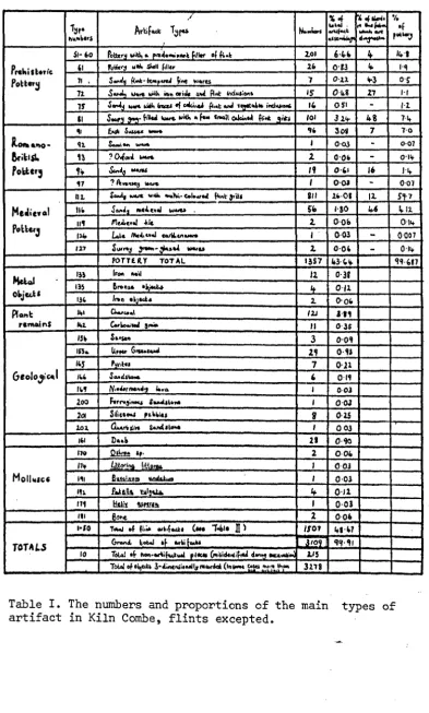
The numbers and proportions of the main
types of artifact in Kiln Combe, flints
excepted
• • •The numbers and proportions of the main
types of flint artifact in Kiln Combe •
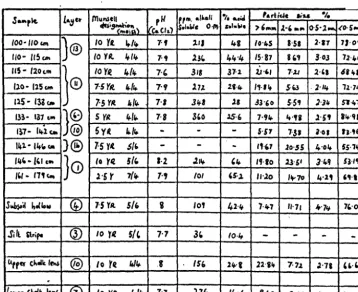
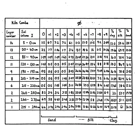
Kiln Combe, Column I, soil analytical data
Kiln Combe, Column, 'II, soil analytical data
Kiln Combe, Column I, particle size data
•
•
(xxiv)
132
145
155
151
relating to material smaller than
2mm(-1
¢)159
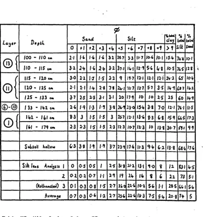
Kiln Combe, Column II, particle size data
relating to material smaller than
2mm(-1
¢)160
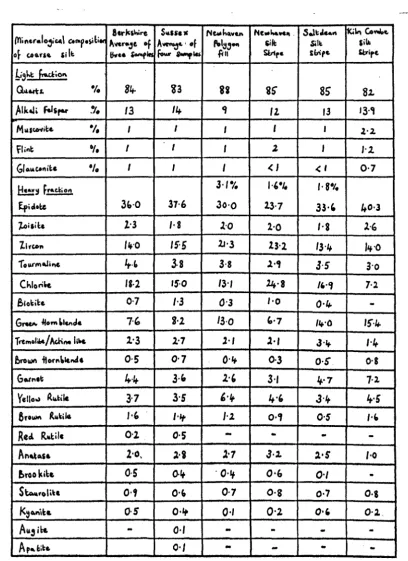
Mineralogical composition of coarse silt
sample from the silt stripe at Kiln Combe
compared to other coarse silt samples of
supposed loessic origin. Table prepared
by Dr. John Catt
•162
Kiln Combe, the molluscs from Column II
and the subsoil hollow
• • •Kiln Combe, the molluscs from Column I and
the lower and upper chalk bands (Layers
1
and 10) •
• • •113
Comparison of aspects of the fauna from the
Medieval hill wash with faunas from lynchet
and hillwash deposits
• •115
XII
XIII·
XIV
XVXVI
XVII
XVIII
XIX XXXXI
XXIIof Itford Bottom.
• •The numbers and proportions of the
artifact types in Itford Bottom, Trench b
Itford Bottom, Trench b, soil analytical
data relating to Columns I and II
> • •Itford Bottom, Trench b, Columns I and II,
particle size data relating to material
snaller than
2mm(-1
15)
•
Itford Bottom, Trench b, the molluscs
from Column 2
•
•
Itford Bottom, Trench b, the molluscs
from Column I
•
•
•
Vertebrate fauna from subsoil hollow 2
and the overlying colluvial deposits
expressed in terms of the number of
fragments.
•
••
•
The numbers and proportions of the artifact
types in Chalton, Trench a .
•
•
Chalton, Trench a, soil analytical data.
Chalton, Trench a, particle size data
relating to material smaller than
2mm (-115)
• •Chalton, Trench a, the molluscs (all
samples weighed
1kg.) .• • • •The numbers and proportions of artifact
types in Chalton, Trench b .
•
•
XXIII
XXIV
XXV
XXVI
XXVII
XXVIII
~.,
Chalton, Trench b, soil analytical data
Chalton; Trench b, particle size data
relating to material smaller than
2mm(-1 ¢) • • • •
Chalton, heavy mineral analysis of soil
at SU 1315 (after Perrin et ale 1914,
Table 3).
• •
• •
•
Micromorphological analysis of sample b
by Dr.
R. Macphail
•
• •
Chalton, Trench b, the molluscs from the
sample column, Samples 13 and 14, and
Samples 1-3 from earthwor.m burrows
•Numerical data relating to the possible
amounts of colluvium and artifacts in
each of the valleys investigated. For
comparison data from a lynchet at
Bishopstone (Bell 1911, pp.251-266)
is included
• • •.. '
-.' ~. "
(xxvi)
360
•
•
•
•
310
CHAPTER I
THE EVIDENCE FOR VALLEY SEDIMENTS AND THE FACTORS WHICH PRODUCED TImv1
(a) Introduction
Valley sediments which accumulated over archaeological time
are increasingly being recognised and provide a potentially
important source of palaeoenvironmental data which has so far been
under exploited. The main contributions of these deposits are
twofold. Firstly, the,y contain stratified biological materials
,i
which will help to establish environmental sequences relating not
to an individual site but to a landscape, something. which will be
of particular importance in eroded areas. Secondly, ,the sediments
themselves are the result of erosion from the neighbouring slopes.
The rate of erosion and sedimentation, together with the nature of
the deposits, is likely to be closely related to land-use. Before
this potential can be fully realised it is important that the
sediments be da~ed. Fortunately it is becoming apparent that many
valley sediments contain, or are stratigraphically associated with,
artifacts or material on which a radiocarbon date may be obtained.
A great range of deposits may occur on valley floors:,
alluvium, colluvium, tufas, lacustrine deposits, peats, and near the
coast there is the possibility of estuarine or ma.rine ,sedim~ts.
Interstratified between all of these there may be standstill
episodes of soil formation. In inland areas we shall. be basically"
concerned with alluvial and colluvial deposits. Alluvial "deposi ts
are the result of depo si tion by running water. As a, result., ~hey, ~:
are liable, to be. sorted to some extent.
defined as those which are transported by gravity ,and ?U!l~-~?<by
weathering. Some writers have extended the definition to include
deposits suoh as alluvium, tufas, aeolian sediments and solifluotion
deposits (Evans 1912, p.281) whilst others include screes and
land~lip deposits (Holmes 1965, p.402). HOwever, in the context
of Postglaoial valley deposits, it has beoome oonv~tional to use
, '
the ter.m colluvium to mean deposits which moved downslope under
the foroe of gravity, as a result of prooesses of subaerial
weathering whioh do not involve major oomponents of wind or water transport. Such processes seem to have, operated mainly on
devegetated slopes as the result of agenoies inoluding the
following: rainspl~sh; seasonal. soil creep; activities of biota;
and anthropogenio effects like tillage. The sediments which result
are oharacteristically unsorted, and this is partioularly marked
where the deposits are the result of tillage. The importanoe of
this factor is emphasised by a tendency in Britain to employ the
terms colluvium, ploughwash and hillwash as if. they were synonyms.
Here the word plou~hwash will be restrioted to examples where the
evidence suggests that oul ti vation played a major part in its
formation.
The sharp division which has been drawn between alluvial
and colluvial deposits is, to some extent, blurred by the faot that
colluvial sequences often oontain a waterborne element resulting,
for instanoe, from exceptionally heavy storms. Furthermore,
colluviation, along with sheet, rill, gully, bank, bed, etc.,
erosion, oontributes material for subsequent riverine transpo,x:tation,
sorting and deposition. Colluvial sediments are also picked up by
running water and transported, to the lakes and ooeans •. , Consequently , ~' " lr , '" ' >' ,~ " ,:. '''' ,
oolluvial deposits only tend to be preserved on any soale, where / there .. .' - ~~ , -. ,,", ..
is little erosion by running wa~er, forinstano~ ,i~ ,dry'.'ya,f.leys.
" 1
..
The catchments from which alluvial and colluvial deposits
are derived are on quite different scales. Alluvial deposits
might derive from anywhere upstream in a river's catchment, and'
changes in the pattern of sedimentation might reflect events many
miles upstream. Colluvial deposits, in contrast, will be largely
derived from the adjoining steeply sloping valley sides, although
there is also a component moving along the more gently sloping
vall ey axi s. In cases such as the majority of dry valleys, where
the slopes contributing to a site are fairly limited, the pattern
of colluvial sedimentation is likely to enable events of a more
local nature to be detected.
Having defined terms it is appropriate to identify some of
the main factors responsible for changes in the pattern of valley
sedimentation. In specifically alluvial situations, all things
being equal, increased erosion and,bedload is liable to lead to
increased sedimentation. Of crucial importance, however,is the
veloci ty of the stream which will be affected by run-off changes
which might result from a variety of factors including climatic
change and land-use changes. Velocity will also be affected by
'base level changes. In coastal areas these are most likely to
be the result of sea level changes, although other factors such
as the inception of coastal bars and changes in salinity can' have
an important influence on the pattern, of sedimentation., 'Upstream,
local changes in base level, produced for instance by beaver dams,
dams, mill-ponds, etc., might also lead to the onset of riverine
sedimentation.
Climate is a factor which affects both alluvial and colluvial
processes, not only through its.effect on rainfall and run-off but
also upon vegetation and the extent of ground cover. : .. ,The i <;,I,'~:: ,;.
importance. of anthropogenic affects, ma.rL induced changes,:: has
also been emphasised by a number of studies of the recent
geomorphological history of river systems, which suggest a
close correlation between land-use and the sedimentation pattern
(Wolman 1967; Leopold 1956; Birks and Birks 1980, p.106). ' If t this is the case today then it is likely that even prehistoric
communi ties had
~ ~fect
on valley sedimentation in view of their known impact on other environmental parameters. Inassessing this evidence we must, as always, be mindful of the
possibility of natural pedological changes. Iversen (1964) has
drawn attention to the process of retrogressive succession in
• plant communi ties brought about by a natural tendency, on
>'
certain acidic deposits, towards more acid soil conditions, for
which there is also evidence in the interglacials. This could
,(,
have led to a loss of soil structural stability and a
concomitant increase in soil erosion though, as Iversen points
out, the tendency towards retrogressive succession is masked in
many Postglacial vegetation communities by anthropogenic effects.
The central theme of this study will be to examine
critically the relative importanoe of these factors in relation
to Postglacial valley sedimentation, and in pa.rtioular to assess
the relationship between valley deposits and land-use. Colluvial
deposits were selected as a basis for s~dy beoause of their more
restrioted catobment and the potential whioh they afford for
reoonstructing the environments of nearby eroded settlement
sites. Original data were collected from
driI
valleys in astudy area comprising the South Downs. In essenoe 1 t is a
regional stu~ of 'a very muohmore widespread p'roblem. For this
reason we need
t~
prefixconsider~tion
of thestudyar~~'~i ~
review of valley sediments, both allUvial arid,
coli~vi8J.·," i~.J
other • ,,' l' " , 1 ~'~ " " " ; • " l" ~', ... _~ E~ ~ ,~, areas, tlieii'€io on
to
~onsider the prooesses re'sponsible"for~"" c,oolluviation before foousing attention on the South Downs.
(b) Mediterranean Valley Sediments.
More work has been done on the relationship between
valley sediments and archaeological evidence in the lIedi terranean
1 ands than in any other area. It has beco~e a co~onplace for
wri ters to contrast the apparent aridity of certain areas with
the rich archaeological remains which they contain, and to
conclude that there has been substantial environmental change
since classical times. Hammond (1967, p.43), in his study of
the Epirus region of Greece, felt that it had experienced large
scale erosion as a result of human activity, and. Wagstaff (1967)
-
.
suggested that erosion was a major factor governing the fortunes
of the small Greek to'WIl of Yi thion. Other writers have gone
much further: EYams (1952) postulated ver,y large scale soil
deterioration and erosion as a consequence of deforestation and
overuse of the land exacerbated by war and strife in areas such
as Attica and the environs of Carthage. It was even suggested
by Jacks and Whyte (1939, p.23) that 'the decline of the Roman
Empire is a story of deforestation, soil exhaustion and erosion'.
A number of classical writers do speak about the effects of deforestation and erosion, but apart from this the evidence
in each of these accounts is largely theoretical, none of them
seeks to identify the physical products of erosion or produce
actual evidence of its causes.
Recently, however, great advances in this direction
have been made by Vita-Finzi (1969) who, as
~
resultof~
investigations all round the Mediterranean, has established
the widespread occur['ence of two distinct -fills. The older fill
~ .
-often forms alluvial terraces bordering Mediterranean valleys , .r'~ " 1 ~ ~~ > :.. . : .. ~, " ., "0', '... >. ~ ;,.
and is an angular illsorted scree which dates from the Wurm cold
episode and need not concern us. For much of the Postglacial
down cutting ensued, interrupted :only by the.: deposition of wha.t is
kno-wn as the younger fill. This is a characteristically buff
or grey deposit consisting largely of silty fine sand. A
rounded and sub-rounded gravel component is restricted to the
margins and the base of. the deposit and bedding is well
developed. In many cases the date of this fill has been
established by its relationship to archaeological material.
Frequently it overlies classical buildings or contains pottery
(Vi ta-Finzi
1969,
Ta.ble 2); in addition there are a number of..
radiocarbon dates (Vi ta-Finzi
1976).
Each of these sources.'
confirms a late, or post, Roman date for the onset of alluviation.
~t what date the younger fill ceased to accumulate is often less
clear, but a date about the beginning of the Post-Medieval period
is indicated in a number of cases. Do-wncutting of the valleys
then resumed and continued up to the present day.
The greatest difficulty is establiShing what factors
were responsible for the brief episode of alluviation represented
by the younger fill. Vita-Finzi
(1969, p.107)
says that. .
'protracted soil erosion could conceivably give rise to a deposit
such as the Medieval fill of the Mediterranean'. In the final
analysis however, Vita-Finzi rejected the idea that the younger
fill was a direct result of deforestation, land-use changes or
over exploitation of the soil, the reason being the clear
synchronism over wide areas of the onset of alluviation. The
argument was that changes relating to land-use would not be
I '
synchronous and that in any case there had been a very long
.
history of clearance and cul ti vation .since the Neoli thic,
'~hich
had been marked by stream downcutting ratherthanalluviati~n.
Itchange in the pattern of stream flow probably from seasonal to
perennial flow, for which there was actual evidence' from one site
in Jordan (Vita-Find 1964), and that this was brought about by
a change in the climate probably related to the Little Ice Age
and 'associated climatic phenomena which were experienced in
Europe during part of this period.
Further investigations of the possible link between
land-use and erosion were made by Sir Joseph'Hutchinson (1969) in
the Epirus region of Greece, an area where classical scholars had
suggested considerable erosion as a result of human activity
(e.g., Hammond 1967). Hutchinson did indeed find evidence
for extensive erosion, but argued that it tended to be localised
and that the suggestion that it was initiated by human activity
remains to be proven. Indeed it was argued that the existence
of older fill alluviation dating to the Palaeolithic period
(Higgs and Vita-Finz11966) argued against an anthropogenic
cause for the younger fill.- Some support for this derives from
areas of Epirus which have recently been devegetated and
unwisely husbanded, the result being an accentuation of linear
erosion and stream incision rather than renewed alluviation
(Harris and Vita-Finzi 1968).
Subsequent studies in Greece and the Greek islands by
Bintliff (1977) have taken as their basis Vi ta-Finzi' s alluvial
sequence and reinforced its chronology from a large number of other
si tes. Again: a climatic cause is suggested, and Bintliff gives acidi tional reasons for rejecting human activity as the major
cause. He points to a small number of pollen diagrams which ,
suggest that early farmers had-a very ,limited effect on the
Greek environment; in many cases, particularly in Northern'
-Greece, woodland clearance seans to have been very recent. For
parts of Southern Greece and islands like Crete, Melos and
Mykon~os it is argued that far from the present thin soils being
remnants of erosion, soil development would always have been
limited due to climate, steep topography and the unyielding
nature of the bedrock.
N'ow that the broad foundations of an alluvial history
for the Mediterranean have been laid there is an obvious need
for more detailed investigation of specific areas in order to
test and expand the existing model. A start has been made with
the stuqy of the river Treia in Etruria, Italy, from the point of
view of the river's history and its relationship to the
neigh-bouring Faliscan town of Narce (Potter 1976a). Two long
trenches were cut across the floodplain alluvium and a
sequence of alternating deposition and erosion phases was
defined and dated by artifactual inclusions. Most of the
sediments' post-date abandonment of the Faliscan town and it is
suggested that they
ar~ ~ontemporary
with Vita-Finzi's youngerfill and climatically caused. It should; in contrast, be
emphasised that a number of other workers have identified
alluviation episodes at dates which conflict with Vit~Finzi's
scheme. Hellenistic alluvial fills are known in Sicily (Judson
1963) and in the Ephesus area of western Turkey (Eisma 1964).
At Elis in Greece rapid alluviation occurred during the Roman
period but very little in post-Roman times (Raphael 1973). More
recent work on
~elos
has pointed to quite different'co~clusions
from those reached by Bintliff: Sediments near the 'site" of"
Phylakopi were investigated (Davidson
~t
al.1976)a.nd:·'t~·
exPosures of colluvial material;
~said' to' be arialagous'to the
: , " • ' . _ .. <~ :',.., ."''4~ , . ~ _:' ,_, -~ , , ' " ' •
Bronze Age. In one case the colluvium sealed sherds of that date,
and in the other there was a radiocarbon date of 866 + 140bc
(SRR-793), from an organic horizon at the base of the colluvium.
Higher levels in the deposit produced finds extending up to the Classical period. The onset of this erosion phase which seems to
have continued intermittently up to the present, is tentatively
associated with the spread of cultivation and subsequent deforestation.
, .
Recent study of soils buried by volcanic pumice on Thera
,
have suggested that the island was the subject of intense soil
erosion by 1500 B.C. (Davidson 1978). This new data from the
Aegean argues in favour of Butzer's (1974; 1976) hypothesis that
the younger fill may often be the ultimate result of much
earlier deforestation. In some cases the soil is likely to
have been held in place umtil terraces collapsed at the end of the Roman period. When this happened streams would have had an
excessi ve load and this would have led to alluviation.
Discrepancies between the various studies highlight the
problem of dating Mediterranean valley fills. This is
.
particularly important because in the absence of any incontrovert*ble
evidence for significant climatic change at this time, the hypothesis
of a climatic cause rests largely on the apparent sychroneity of
alluviation. The evidence does, however, show that the onset of
younger fill deposition varies by as much as five hundred years
according to location, and Butzer (1974)' suggests that this is strongly in favour of an anthropogenic cause.' . In reply to this
Vi ta-Finzi (1976) suggests there is evidence of diaclll-onism; with
later dates from more southerly latitudes, possibly resUl. tingfrom a temporary southward shift in the European
dep~ession
bei'ts. ',':Problems also attend the dating of alluvial sequences on the basis
of a small number of sherds, which can never provide more than a
terminus post quan." Sherds of classical date are inherently
likely at some level in most Mediterranean valley fills, the
fact that they occur does not necessarily date the whole deposit
which might have built up over a long period. Certainly this seans to have been the case with sediments investigated on Melos
(Davidson et al. 1976) and the British colluvial sequences studied
in the course of this research. Similar doubts attach to
Bintliff's statements that the younger fill is of comparatively
rec~t origin because it does not contain any prehistOric sites,
something which is particularly apparent in the large areas of
coastal plain and deltaic deposits. This does not, however, rule out the possibility that much earlier alluvial material lies
buried in these areas, and that there may conceivably be prehistoric
sites interleaved within it.
The problan of isolating. the causes of valley deposition
seans also to have been hampered by difficulties in distinguishing
between alluvial, colluvial and deltaic deposits. Since the
younger fill is characteristically well sorted it is presumably of
largely alluvial origin. However, some of the coastal plain and
river mouth deposits discussed by Bintliff sean likely to have a
del taic component. As for the origin-of all this material
deposited as the younger fill, Vita-Finzi (1975) maintains that it
c<?nsists largely of material derived from the older fill, but he
admits elsewhere (1974a) that itis.difficult to ascertain to what
extent erosion on the interfiuves is responsible. One or
two
~ , "',
pieces of evidence do hint at the possibility of fairly substantial
, { 'r~ ~
sheet erosion and colluvial contributions. In Epirus the soil • • >
surface level has fallen significantly ~uring the life of olive
"~ , " ~' ... ':, ' • 1~ • , ' • ~ "
.
.trees a few hundred years old, indicating erosion rates of about
200m. per century close to villages, and about 250m. over a few
hundred years away from villages. Further evidence comes from
central Italy where substantial lowering of the ground level has
occurred since the erection of several Roman buildings,
suggesting erosion rates of between 3 and 100m. per century.
Even if we accept these average figures as reflecting approximately
the right order of magnitude it is difficult to be sure of their
significance in pedological terms. That depends on an unknown factor - the rate of rock weathering and pedogenesis, and we do
not know whether they could have made good erosion losses without
significant changes of soil type. Even in the absence of these
data pedological changes on the interfluves do sean to be a
distinct possibility, so perhaps we should exercise caution before
accepting Bintliff1s (1977, p.37) statement that soil types in
parts of Southern Greece and the Greek islands reflect those which
existed in prehistory. From bis own comments, however ,(p.537) and
from the work of Davidson et al.(1976) and Davidson (1978), it is
evident that this point of view is not shared by the majority of
ecologists and pedologists working in the area. In view of these
possibilities it is curious that VitlrFinzi, Hutchinson and
Bintliff are united in suggesting that the effects of the younger
fill episode were more beneficial than deleterious. The younger
fill is, they argue, a concentration of rich soil in the bottom
lands where there is. available moisture with the result that this
recent alluvium has become the heart of to day I s Mediterranean
agricul ture (Vi tlrFinzi 1966, p.17S). Again without more
information about earlier soil types the truth of this idea is
.~
difficult to establish, but Butzer (1974, p.68) has pointed out
·
.that the original soils would have been much more erlensi ve before
being reworked into deep restricted valley fills. Furthermore
there is evidence for the selective depletion of clay and silt
during the deposition of the younger fill (Vita-Finzi 1975).
Perhaps, therefore, these deposits were more retentive of
moisture prior to reworking, and under different vegetation
condi tions they might also have had a higher organic matter
content.
(c) Valley sediments in· Europe.
A number of regional surveys exist of valley deposits in
Europe; hitherto they have been largely ignored in discussions of
the Mediterranean and British seOiments with which they afford a
most interesting comparison. Postglacial floodplain silts,'
known as Auelebm, are apparently widespread in Germany. Their
average thickness is 1 - 2m. but occasionally they are between
B
and 6m. thick. Those in the East German provinces of Saxony andThuringia have been investigated by Jager (1962) who identified
two main periods of deposition dated by artifacts; one in the
late Bronze Age and early Iron Age was only present in certain
valleys, the other dating to the Middle Ages was on a. considerably
larger scale and more widespread. Jager argues that these deposits
were the result of forest clearance followed by tillage which led
to large scale soil erosion. In fact the date of the Auelebm
does correlate to some extent with the intensity of settlanent,
there are a number of Bronze Age deposits in i.:laxony, which was
intensively settled at this time. In contrast to this are sites
in the high mountains which produce relatively late dates,
indicating that those areas were intensively settled much'later.
Auelebm deposits in North West Germany, particularly in