Gamifying Navigation in Location-Based
Applications
Stephanie
Githa
Nadarajah
1,
Benjamin
Nicholas
Overgaard
1,
Peder
Walz
Pedersen
1,
Camilla
Gisela Hansen Schnatterbeck
1, Matthias Rehm
1,∗1DepartmentofArchitecture,Design,andMediaTechnology,AalborgUniversity,Denmark
Abstract
Location-based games entertain players usually by interactions at points of interest (POIs). Navigation between POIs often involve the use of either a physical or digital map, not taking advantage of the opportunity available to engage users in activities between POIs. The paper presents riddle solving as a navigational method for a location-based game. 10 families with 2-6 persons and at least one child in the age range 9-11 years old participated in the evaluation. Results show that riddle solving as a navigational method is more enjoyable than a 2D digital map. Additional findings from video recordings, field notes, questionnaires, logging and semi-structured interviews revealed that riddle solving has potential for engaging users in learning activities.
Received on 22 November 2016; accepted on 06 September 2017; published on 09 October 2017 Keywords: Location-based interaction, gamification, navigation
Copyright © 2017 S. G. Nadarajah et al., licensed to EAI. This is an open access article distributed under the terms of the Creative Commons Attribution license (http://creativecommons.org/licenses/by/3.0/), which permits unlimited use, distribution and reproduction in any medium so long as the original work is properly cited.
doi:10.4108/eai.8-11-2017.153333
1. Introduction
It is our conviction that the city can become the key element in creating smart learning environments that transcend traditional institutionalized learning by bringing learning back to where it originally belonged: everywhere. Our vision of smart city learning is to create a public space for learning experiences that transcend into all areas of life while at the same time establishing traditional institutions (like schools, libraries, museums, etc.) as hubs for information gathering and collaborative interactions. The city itself, becomes an enchanted place allowing for discovering hidden knowledge in a playful manner. The StreetArt project is based on previous work that realizes an exploration game that is supported by a virtual tour guide in the form of a monster and situated in a museum context [26]. As the application is targeting younger children between 6-10, the playful back story for the guide is that it has eaten some of the artworks and – as we all know – "you become what you eat". This is taken literally here, where the monster’s body is textured by the artworks it has eaten and the task
∗
Corresponding author. Email:[email protected]
is now to find these artworks. Scaling up the museum experience to the city level revealed a big challenge – travel time between points of interest. In standard location-based games (LBG) this is lost time because interactions only happen at POIs. In this project we aim at integrating travel between POIs with the enfolding narrative of the LBG.
We found that existing research on location-based games primarily deal with the local interactions at points of interest (e.g. cultural heritages), rather than on what happens in between. Only few location-based games use methods other than maps to guide players. The following study is an attempt to address this problem by evaluating the effects of a location-based game experience for tourist families, where the players are guided to points of interest without the use of map opposed to the same game experience with the use of a digital map.
2. Background
Avouris & Yiannoutsou [2] reviewed fifteen location based games (LBGs) and categorized them as either games designed for player enjoyment (ludic), education (pedagogic) or a combination of both (hybrid). The authors found that LBGs take place in a physical space
EAI Endorsed Transactions
(e.g. going to a specific physical location) and require some interaction by the player in the virtual space (e.g. solving puzzles or interacting with an avatar). This results in an interplay between the physical and virtual space, creating what is known as the game or narrative space. They also found that narrative was an underlying element in all LBGs. From this, we define LBGs as game experiences that connect the physical space with the virtual space and make use of an underlying narrative elements.
2.1. Activitiesin Location-basedGames
In order to describe the game activities of LBGs, we first look into what constitutes a game. There are a range of different definitions of games, however McGonigal [19] proposes four defining traits of games which fit the scope of our project. Games must have a goal, rules, a feedback system, and voluntary participation. The goal of the game is the specific outcome which players aim to achieve and what gives players a sense of purpose. The rules set limitations or remove obvious ways of getting to the goal and push players to be creative and use strategic thinking. The feedback system informs players about their progress in achieving their goal e.g. through points, levels, a score, or a progress bar. This gives a promise to the player that the goal can be achieved and thereby provides motivation to keep playing. Voluntary participation requires that all players accept the goal, rules, and feedback, thereby establishing a common ground for players to play together.
Pedagogical games explicitly have the purpose of educating the player through informal learning. Informal learning is learning that typically does not take place in classrooms, is not highly structured, and where the control of learning rests in the hands of the learner [18]. Incidental learning is informal learning that occurs when people are not conscious of it, e.g. as a result of completing a specific task. According to Avouris & Yiannoutsou [2], these games typically have a strong narrative and use role playing by making players enact certain roles to comprehend complex scenarios. In these games, it is assessed that it is particularly important that the physical and virtual have a strong interplay to support learning. There are though a range of examples, where the relation between location-based interaction and learning goal is more arbitrary and the goal seems to be to solely get students out of the classroom ([22]; [31]). Väljataga and colleagues [31] describe a typical example of this kind of game, where teachers can create tasks for students (usually questions to be answered) at random locations on a predefined map.
While the focus of ludic LBGs is enjoyment, learning is often an implicit element, since players might develop skills such as exploration and orientation e.g.
by navigating a city. This is especially seen in treasure hunts, where players typically move to certain physical locations and use the physical space at the location for some interaction in the virtual space. An example is MythHunter, which allows players to solve quests by exploring historically relevant parts of the city [15]. Gentes et al. [12] describe treasure hunts as experiences that encourage people to pay attention to details in the city and read the cityscape by looking for clues. An example of this can be seen in the LBG Team Exploration, where players work together to compare pictures in the virtual space to real physical locations in Paris in order to figure out which areas of a map the pictures were taken at. The goal of the game is to reach the final location within a certain amount of time . This limitation made players experiencing the game more as a race, which made it difficult to enjoy the city at the same time. Gentes et al. describe this as a tension that exists in treasure hunts between the attention players allocate to the discovery of a place and the hunt itself. Furthermore, the evaluation showed that players wish they had some proof that they had been at certain locations, e.g. by being able to save a picture of the location in order to make the visit more meaningful. As these pictures would act as proof for progression, this indicates that the ability to save information about the places visited is a fitting way of incorporating feedback systems into treasure hunts. Treasure hunts also typically allow players to collect virtual objects at certain physical locations [2], such as in Insectopia, where the players collect virtual insects, which represent points and act as both the goal of the game as well as an indication of progression and feedback system [23].
play and narrative as the majority of pedagogical and hybrid games, it still manages to incorporate knowledge of the physical space while keeping players engaged according to the evaluation of the game [6].
2.2. Narrative in Location-basedGames
Different disciplines define the term narrative focusing on different characteristics [14]. A narrative can e.g. be defined as ’a perceived sequence of non-randomly connected events, i.e., of described states or conditions which undergo change (into some different states of conditions)’[30]. When looking into interactive narratives, it is important to understand the concept of player choice. The quality of a game design can be characterized by looking at the relationship between the player’s choice and the system’s response [28]. This relationship should both be supported in terms of the feedback system of the game such as receiving points, known as discernable relationships as well as in the larger context of the game, affecting the overall goal, where the outcome of the game should rely on players’ choices, known as integrated relationships [28]. This can be related to interactive narratives, which offer players choices and the ability to navigate within a multi-linear branching structure of the narrative, thereby influencing the narrative [27]. Another example is given by Frank and colleagues [11] that develop a system, which adapts learning goals (and thus the corresponding narrative) to the navigation path of the player, thus making sure that information presentations at POIs is non-repetitive and coherent.
Khaled et al. [16] highlight, how an interactive narrative can be used to explore both the physical as well as the virtual space. InStoryTrekthe story develops as the user moves in the physical space. The authors observed that contrasts between what happend in the narrative space and the physical space forced the users to pay close attention to the physical setting, in order to make sense of the experience. A qualitative study made by Blythe et al. [5] investigated the enjoyability of an LBG calledRiot!, where users experience a story through sound that changes dynamically in relation to their location in a city, thus promoting a strong interplay between the physical and virtual space. Results show that Riot! scores high on enjoyment, indicating potential in using sound to create a strong interplay between the physical and virtual space. However as the following section reveals, using sound also has limitations in the context of LBGs for group experiences.
2.3. Navigationin Location-basedGames
LBGs utilize points of interest (POIs) in their gameplay, which brings up the requirement of navigating between POIs. In a city context, this opens up opportunities
to gain additional knowledge of the city during navigation. From research into existing LBGs, we found that the potential in getting familiar with the city while begin on the move has not been fully utilized, since LBGs often focus solely on activities at POIs. One examples is presented by Gordillo et al. [13], who made a hybrid LBG for tourists. The game offered three POIs which were marked on a 2D map, requiring the users to go there in order to trigger activities provided at the location. The long distances between POIs (in one case three kilometers) basically brought the game to a halt until arrival at the respective POIs. Several LBGs have used 2D maps utilizing GPS technology (e.g. Google Maps) in order to guide their participants to POIs ([8]; [13]; [33]; [7]; [3]; [24]; [4]). To the best of our knowledge, none of these have integrated game activities into the navigation. Furthermore, we have not been able to find any studies that investigate or evaluate whether navigating with a 2D map is a good choice in the context of LBGs.
In the previously mentioned study by Blythe et al. [5], players navigated freely in a restricted area. However, its design may only be appropriate in a small bounded area due to the extended freedom of exploration, and could be problematic if transferred to a larger scale (e.g. an entire city) due to longer distances between POIs. Epstein & Vergani [10] made a similar study on a walking tour in Venice, which incorporated the narrative space into the navigation, but kept a more linear narrative structure . A narrator in the application verbally explained where to make turns, and at the same time made comments on the physical environment. The outcome of the study did not reveal the users’ experiences concerning the navigation. Both systems encouraged users to explore, but due the use of headphones focused on individual users. In our case, we work with families, making the sharing of information a requirement. Thus, utilizing sound either with or without headphones poses a number of practical challenges in relation to communication, safety, and noise level.
physical map using augmented reality. The authors compared it to a 2D map known as DigiMap focusing on flow, presence and intrinsic motivation (IMI). MapLens had significantly lower scores than DigiMap in most of the questions concerning flow, presence and IMI, but its potential was revealed in terms of social interaction, since MapLens encouraged collaborative behaviour. This is supported by Kuikkaniemi et al. [17], who compare MapLens and navigating by following QR codes. The authors did not find MapLens particularly useful based on observations of participants and report that participants rarely used MapLens. The QR codes on the other hand are described as a fun way of navigating both indoors and outdoors, but it remains unclear why that is the case. The QR codes did not promote any environmental awareness, making the interplay between the physical and virtual domain weak.
As mentioned earlier, hybrid LBGs require a strong interplay between the physical and virtual space, supported by game activities and a narrative with the goal of creating an enjoyable learning experience. Based on the above findings, no LBGs have integrated these requirements into the navigation between POIs. In the following, we suggest wayfinding with landmarks as a potential method for this integration. Wayfinding using landmarks is a navigational method in which objects or structures in the environment are used as points of reference, and it is typically used in the communication of route directions [25]. Route directions provide procedures and descriptions that help people build mental representations of the environment they are about to traverse. When following a route, landmarks can be used for re-orientation at decision points such as road intersections and are known as ocal landmarks. Landmarks can also be used for confirming if people are on the right path, known as route marks. Finally, landmarks can be used for overall navigation, known as distant landmarks. Landmarks can be described by their saliency, which defines how much a landmark stands out from the surrounding objects in its environment. Different types of landmarks have different types of saliency. Sorrows and Hirtle [29] categorize landmarks as either visual, cognitive, or structural. The saliency of visual landmarks can be characterized by their visual contrast to surrounding objects, e.g. based on the size, shape, position or age of a landmark. For cognitive landmarks, the saliency depends on the meaning of the landmark, e.g. due to the landmark being culturally or historically important. The saliency for structural landmarks depends on the accessibility of the landmark, e.g. the amount of locations a landmark is visible from.
As wayfinding using landmarks is a navigational method that uses objects in the environment, we see potential in using it in combination with game activities between POIs for LBGs. This could result in
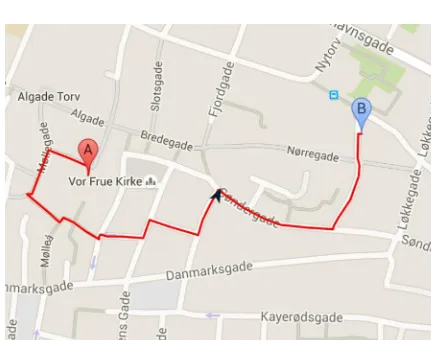
Figure 1. The routebetweenthe three street art paintings.
a stronger interplay between the physical and virtual space during navigation between POIs. Furthermore, using landmarks is based on vision instead of sound, indicating that it might be suitable for a group experience.
3. Lost on Earth
In order to measure enjoyability of landmark navigation in combination with game activities in a location-based game (LBG), we developed a LBG that takes place in Aalborg, Denmark. The game focuses on street art paintings [1] that were used as points of interest (POIs). Players have to walk between three POIs on a route with a total length of 1.8km and a distance of 0.9km between POIs (see Figure1). The particular route was chosen on the basis of it having approximately the same amount of intersections in the road between POIs, as well as approximately the same distance between the POIs.
3.1. Choiceof NavigationalGameActivity
Four initial designs were created as paper prototypes possible game activities that support wayfinding with landmarks. One was chosen to be used in the game on the basis of a preliminary test on three families. The tests were carried out using within-subjects design, thus each group of participants tried out all four prototypes. The purpose of the tests was to determine which game activity the participants found most enjoyable, based on a questionnaire and short semi-structured interviews conducted between game activities as well as after trying all four activities. The participants of each test were a child in the age group of 8-11 years old and the child’s parent. We followed the participants during the activities, documenting the tests and interfering, if they got lost or had other problems. The initial designs were paper prototypes with a focus on the navigation.
in a LBG. Three navigational game activities were made as variations of matching card games such as Concentration[32]. In these types of games, players try to find two or more cards that are alike, among a set of cards, and the goal is typically to be the player with the most matches in the end. InTeam Exploration [12], players matched pictures in the virtual space to landmarks in the physical space and progressed in the game by specifying which pictures belong to certain areas of a map. Based on this approach, we created three matching game activities:Simple Matching,Order Matching, andMemory Matching.
For all game activities, local landmarks are used to help players choose directions at decision points, and route marks are used along streets to confirm to players that they are walking in the correct direction. In Simple Matching, players are given a set of potential landmarks, where only one of them is a true landmark in their current location. When they spot or match the landmark that is shown on the picture, they go to its position and start matching the next set of pictures. This activity proved to be the easiest of the four and most participants found it to be uninteresting due to its lack of challenge. Order Matching is very similar to Simple Matching, as the only difference is that players have to specify the order in which the presented landmarks occur from their current position. Participants found this activity to be a bit more challenging, however due to the requirement of ordering landmarks, participants sometimes walked back in the direction they came from. Through observation, it was clear that the participants collaborated more in this activity due to the increase in difficulty. In Memory Matching, the landmarks had to be ordered, but were only presented shortly before navigating. When participants then reach the last picture in the set, they are asked to specify the order of landmarks encountered. Through observation and interviews, it was clear that participants found this activity to be the most challenging of all matching activities. This also caused participants to collaborate more, where they e.g. each would remember half of the pictures. Furthermore, participants mentioned that only being able to look at the pictures at certain points, caused them to look more around and notice the environment during navigation.
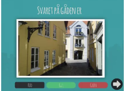
The last game activity is based on riddles and is similar to the game I Spy [32]. Players must spot a specific object in the vicinity based on a clue that is given to them. This approach is inspired by the LBG CityTreasure, where riddles are used at POIs. In the context of landmark navigation, the riddles describe saliency based on the visual, cognitive or structural attributes of the landmark, either in isolation or in combination (E.g."I am tall and you can see through me"). In order for players to confirm that they have found
Figure 2. Controlquestionafter havingfoundthe landmark.
the landmark, they are also given a control question about the landmark with three possible answers (E.g. "What does the sign beneath the things you can see through say?"). This is a failsafe against GPS glitches, ensuring that players actually reached the right position. At the same time, this control question allows for including knowledge about the landmarks in the game activity, thereby supporting pedagogical elements in the game. By being able to confirm if the player has found the landmark, it is possible to create a feedback system in the game. Upon answering the control questions, regardless of the players’ answer, a picture of the correct landmark is shown to the players, so they never get lost. Through interviews, we found that most participants preferred navigation with riddles and described them being the most fun. It was also clear that riddles were the most challenging for the participants, mainly because people were unsure of the scale in which the landmarks could be found. This is due to the fact that participants have nothing visual to compare to in opposition to the matching activities. However, it could also be seen that this limitation contributed to the enjoyability of the activity. We also observed that this limitation caused participants to collaborate and in general communicate more during navigation. Based on these results, there were strong indications that navigation using riddles was the most enjoyable activity. For this reason, riddles were chosen as the navigational game activity forLost on Earth.
3.2. GameDesign
Figure 3. Riddle-based navigation showing the monster
character withpointsin the formof fuels and friends.
the monster has eaten. The monster gives the player feedback and integrates the narrative throughout the game.
Similarily, in Lost on Earth, the player assists a monster character (see Figure 3) in reaching a specific goal, using street art in Aalborg as the POIs. In our game the narrative is built around the monster being stranded on Earth. Since the players’ goal is to find landmarks, we designed a narrative that reflects this, by also giving the monster the goal of finding something specific. As the monster is stranded on Earth, it needs to find fuel for its spaceship to fly home. However, the monster is also looking for its friends, who also are stranded on Earth.
Due to the importance of choice and interactive narratives in games, as earlier mentioned, players have the ability to choose whether the monster should look for fuel or friends, which will affect the outcome of the game. These choices are made at the street art paintings. Ideally, different routes should be used for different choices, however to minimize the amount of bias in the experiment, the illusion of choice is given, as the choice will only influence the outcome of the game, not the route to be taken. The choice is made through a dialogue with characters in the street art paintings, which starts as players augment the paintings at the POIs. To incorporate pedagogical elements, information about the painting itself is given through the dialogue, and after augmenting the painting, players unlock access to an info screen about the particular painting. This was included, in order to incorporate the element of saving information about places visited, mentioned previously by Gentes et al. [12] and Peitzl et al. [23], giving the user a sense of progression and feedback.
In the game activity between POIs, players use riddle solving to navigate. When players start their first riddle, a tutorial introduces how the system works. To incorporate a feedback system, players are given points
Figure 4. Map-basednavigationusing mapprovidedby Google
Maps showinguser’s position
when they answer correctly on the control questions for the riddles. These points are dependant on the choice made at the previous POI, so for instance in the case that players have chosen to look for fuel, fuel points will be given to the players and vice versa (see Figure 3). Whether the monster will get home or have found their friends in the end of the game, will rely on this choice. We also implemented a 2D digital map into the game for the purpose of the experiment (see Figure4).
4. Experiment
The experiment took place over two weekends in central Aalborg, Denmark. Participants used an iPad 2 3G + WiFi running the Lost on Earth application, which was developed using the Unity3D game engine. To investigate the effects of riddle solving as the navigation method in a location-based game, we conducted a comparative study between navigating by riddle solving and navigating by a 2D map with GPS. The experiment was guided by the following hypotheses:
H1: Riddle solving as a navigational method is more enjoyable than map navigation (due to game elements).
H2: Riddle solving as a navigational method results in a higher feeling of flow than map navigation (due to game challenges).
H3: Riddle solving as a navigational method creates a larger sense of spatial presence than map navigation (due to increased interaction with physical surroundings).
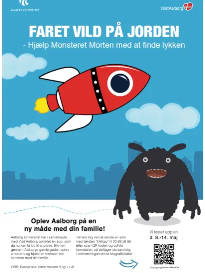
Figure 5. Poster for recruitingparticipantsfromlocal schools.
counterbalanced with the purpose of reducing the environmental effects met on the route on the results. Participants would either begin with map or riddles, and would end with the navigational method different from the one met in the beginning.
4.1. Participants
Ten families of 2-6 persons were recruited through posters at local schools (see Figure5). As the narrative of the game is targeting children, it was a requirement that the families had at least one child in the age range 9-11 years old. 17 children participated with ages ranging between 7 and 13 (mean = 10.1, SD = 1.6), 9 females and 8 males. 14 adults participated with ages ranging between 36 and 62 (mean = 42.3, SD = 6.4), 4 females and 10 males. All participants lived in Aalborg or nearby, and were familiar with the city as well as with using tablets or mobile devices.
4.2. Materials and Procedure
Three streetart paintings, A, B and C, were a part of the experience (see Figure 3 – right). The distance from A to B was 0,9 km and the distance from B to C was 0,9 km. Each condition also had approximately the same amount of turns, respectively 8 and 7 turns. For each session, one of the parents was instructed to wear a GoPro with a harness for recording video, while one of the children carried a bluetooth microphone
Table 1. General results
Dimension R M
Intrinsic Motivation
total (**) 4.31 3.64
Enjoyment (**) 4.49 3.46
Pressure 2.11 1.78
Effort (*) 4.30 3.68
Perc. Comp. 4.13 3.68
Flow
total (*) 3.85 3.60
Presence
total 3.07 2.95
Note: (*) = p<.05 and (**) = p<.01
Table 2. Itemspecifi results
Item R M
Intrinsic Motivation
I thought navigating was fun (**) 4.48 3.42 I thought navigating was boring (**) 1.41 2.14
I enjoyed navigating (*) 4.29 3.46
I was pretty good at navigating (*) 4.41 3.73 Flow
I was focused on navigating (*) 4.16 3.66 The experience highly rewarding (*) 3.93 3.15 I felt like time went by quickly (*) 4.54 3.69
Note: (*) = p<.05 and (**) = p<.01
for recording audio. All parents signed consent forms and filled out demographic questionnaires prior to the experience. We gave the child in the age range 9-11 years old the iPad, but they were not forced to handle it the whole session.
The questionnaires in this study contain questions from the Short Flow State Scale Questionnaire (S-FSS 2), which measures the degree to which flow dimensions characterize the complete experience[20]. The questionnaire also contains questions from the Intrinsic Motivation Inventory (IMI), which measures enjoyability, tension, effort and perceived competence as well as from a Spatial Presence Questionnaire (MEC-SPQ) for measuring spatial presence, allocated attention and suspension of disbelief. Only adults received this questionnaire due to the level of complexity, while children received a simplified questionnaire measuring enjoyability using IMI. Both questionnaires were measuring on a five point Likert scale, going from 1 (strongly disagree) to 5 (strongly agree). Logging, field notes, interview and video data was used for supporting the analysis of questionnaires.
4.3. Results
for intrinsic motivation, flow and presence. Significant effect for intrinsic motivation esp. on the dimensions of enjoyment and effort shows that riddles were more motivating and enjoyable. Riddles also received a significantly higher score than maps concerning total flow. No significant difference was found for presence, but riddles was still favoured in terms of its score. Table2gives results for specific items from the intrinsic motivation and flow questionnaires that showed significant differences between the ratings for riddle-and map-based navigation. Riddles were significantly more fun and less boring. Adults found the riddles significantly more rewarding and had the feeling of time moving faster compared to the map version. These two questions specifically assess the dimension of having an autotellic experience and the sense of time transformation. As flow involves nine dimensions, these two were the only dimensions to reveal a significant difference. Additionally, children thought they were significantly better at navigating with riddles than maps. A multiple ordinal regression analysis was performed in order to investigate, whether age, gender, condition order or group size served as predictors for the results. In all cases, the results stayed significant, but the condition order had a significant impact on several of the questions concerning enjoyability in IMI. Due to the condition order, the selection of riddles was different for each condition, as well as the route described on the map. Participants met different landmarks on the route based on the condition order, which eventually provided a different experience between conditions.
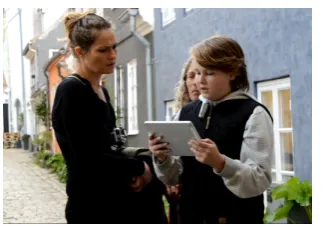
4.4. Observations
During the experiment, the facilitator walked behind the families and took general notes on the interaction of both conditions. The biggest differences between the two conditions could be seen in regards to the partici-pants’ social behaviour. In general, there was more com-munication between participants during riddle nav-igation than during map navnav-igation and the topics were different. During riddles, participants primarily talked about the environment and collaborated to solve the riddles, while during map navigation participants tended to talk about things outside of the game, e.g. one child started talking about his soccer practice. However, this mostly tended to happen on long paths without intersections, as these areas require less attention from users during map navigation. From this, it seems that riddles in general require more attention than maps (see Figure6).
For both conditions, collaboration was mostly seen between the child using the iPad and a parent. Here, the parent would act as an assistant to the child and take over the iPad if the child gave up (see
Figure 6. All participantsattendingto the iPad, trying to solve
the riddle
Figure 7. Childin chargeof the iPad (left) and parentassisting
the child(right)
Figure7). If there were multiple children, the children not holding the iPad would often have a hard time participating in the navigation and would just follow the group. This indicates that the design does not fully encourage collaboration between multiple players, and it is possible that the collaboration between child and parent naturally arises from the fact that parents are used to assisting their children. During this collaboration however, it was clear that if the riddles were too difficult for the children, but the parents knew the answer, the parents would give their children hints in order for them to solve the riddle. From this, it could be seen that harder riddles encouraged more communication and collaboration.
Regarding the riddle system, it was clear that a better explanation of the system to the participants is needed. Often participants would answer the riddles without going to the position of the previous landmark first, which caused frustration since participants would not be able to find the landmarks used in the riddles. Especially families that used riddle navigation for the second part of the route, had a hard time understanding the system. This indicates that the tutorial built into the system did not provide clear enough instructions. Furthermore, the riddle system is shortly explained by the facilitator in the beginning of the experiment, and this information might have been forgotten as participants reached the second part of the route.
participants to walk down wrong paths, and it could take several minutes for the signal to be re-established, causing confusion in the participants. As a result some participants ended up reaching the destination by taking completely different paths, and in one case, it was necessary for the facilitator to guide the participants.
Finally, it was observed that people in general looked around and paid more attention to the environment when solving riddles than when using a map. During map navigation, the participant holding the iPad primarily looked down on the iPad, and it was mostly at intersections that participants looked around in the environment. It was also observed that especially when the GPS signal was weak during map navigation that participants looked down on the iPad.
4.5. Interviews
Despite results from questionnaires being statistically significant, showing that riddle solving is a more enjoyable navigational method than maps, findings from interview data allowed for deeper analysis into the effects of this method. Five out of 22 children expressed preference towards using maps. One parent mentioned that she preferred maps, saying "It is just always fun to follow a map". This parent explained that they were unsure about what to do during the riddle-based navigation and could not remember what they had been told during the instructions.
Another parent mentioned that maps are easy and did not make one aware of the surroundings, because the focus was on walking. In general, we found different opinions on whether the different navigational methods made people aware of the surroundings. One parent clearly stated the children were not interested in the map at all. In line with six other test participants, this parent expressed that it was fun to notice things in the environment they usually do not notice when walking by, making it an optimal method for tourists. Opposed to that opinion, another parent expressed that she focused more on navigating than noticing things in the environment. With riddles, one parent felt that the attention was on the next location to go to, while the map made the participant more aware of the city, because there was more time to look around in the surroundings.
When asked if they would use riddles as navigational method, if they were to use it in another city, all test participants agreed and answered yes. Some thought it would be a more fun way of explorng a city and that it would make it possible to see the city in a different way. However, interview data also clearly revealed that several participants would have enjoyed it more, if the riddles were about more interesting landmarks that gave the possibility to learn more e.g. about the city.
Preferably this should be done with the children in mind and a few parents proposed a system that could be adjusted depending on the childrens’ age. Riddles as navigational method was described as "fun if you have time for it"by one parent.
The most used word to describe riddle-based navigation was "fun" (11 of 29 words). This reflected the results from the questionnaires. Other words included exciting, challenging, different, educational and inspiring. Some participants thought it was fun to answer the questions after the riddles, particularly one child mentioned that it was fun to be able to answer correctly to questions. Results from the log further showed a high tendency of correct answers to control questions (in average 96,9 % of the control questions across all sessions were answered correctly), indicating that the feedback system had an impact on the enjoyability of the game. One parent mentioned that the fun part in the riddle-based navigation was to help each other and agree on what they have seen in the environment. Several parents had a similar opinion and stated that they enjoyed collaborating and discussing the answers with the other family members.
In terms of group dynamics, it was mentioned that primarily the one with the device was in control (see Figure 6), making it a less collaborative experience. One parent mentioned that they collaborated more, when navigating using riddles and not as much with the map. In order to make it more collaborative, one of the participants suggested making the riddles more difficult, encouraging the participants to help each other. This statement supports the experience of another parent, who mentioned that they only collaborated when there were doubts, otherwise they just followed the child, who was in charge of the device. In general there was a tendency to let the child control the device.
4.6. Discussion
getting feedback. This supports that incorporating game activities into the navigation makes it more enjoyable for the players. We found no significant results about presence, though riddle-based navigation scored higher on making the participants aware of their surroundings. Despite not being the main focus of this study, we observed some interesting elements in terms of social interaction among participants. Even though we did not find any statistically significant results supporting that participants helped each other more during riddle-based navigation, we found in the post-interviews that riddle-based navigation has potential in motivating groups of people, making it a enjoyable group experience rather just a matter of getting from A to B. We observed that participants discussed more and that topics revolved around solving the riddles and discussing the landmarks. Though this requires a more thorough analysis of the interaction among the participants, we hypothesize that riddle-based navigation has potential in supporting learning e.g. about landmarks or developing skills in terms of exploration, particularly in a group context.
5. Conclusion
In this study, we investigated the effects of riddle solving as a navigational method in a location-based game experience for families. We compared this navigational method with a 2D map, which is a common navigational method to get from one POI to another in location-based games. We found significant results indicating that riddle solving as a navigational method is more enjoyable than a 2D map. Though perhaps not being a more intuitive navigational method, riddle-solving clearly suits the need of location-based game experiences, as it makes use of the physical space to navigate from one POI to another, while also adding more enjoyment to the experience. We recommend looking into using this or similar approaches to create not only enjoyable, but also educational experiences.
Acknowledgement. We would like to thank Martin Lynge Jensen for support in adapting the Monsters Eat Art project and VisitAalborg for their kind collaboration.
References
[1] Streetart in Aalborg. http://www.visitaalborg.dk/
street-art-i-aalborg.
[2] Nikolaos Avouris and Nikoleta Yiannoutsou. A Review of Mobile Location-based Games for Learning across
Physical and Virtual Spaces. Journal of Universal
Computer Science, 18(15):2120–2142, 2012.
[3] Rafael Ballagas, André Kuntze, and Steffen P. Walz.
Gaming tourism: Lessons from evaluating rexplorer,
a pervasive game for tourists. In Proceedings of the
6th International Conference on Pervasive Computing,
Pervasive ’08, pages 244–261, Berlin, Heidelberg, 2008. Springer-Verlag.
[4] Marek Bell, Stuart Reeves, Barry Brown, Scott Sher-wood, Donny MacMillan, John Ferguson, and Matthew Chalmers. Eyespy: Supporting navigation through play. InProceedings of the SIGCHI Conference on Human Factors in Computing Systems, CHI ’09, pages 123–132, New York, NY, USA, 2009. ACM.
[5] M Blythe, J Reid, P Wright, and E Geelhoed.
Inter-disciplinary criticism: analysing the experience of riot!
a location-sensitive digital narrative. Behaviour and
Information Technology, 25(2):127–139, 2006.
[6] L Botturi, A Inversini, and A Di Maria. The city treasure.
mobile games for learning cultural heritage. Museums
and the Web 2009: Proceedings, Indianapolis, 2009. [7] Tara Carrigy, Katsiaryna Naliuka, Natasa Paterson, and
Mads Haahr. Design and evaluation of player experience of a location-based mobile game. InProceedings of the 6th Nordic Conference on Human-Computer Interaction: Extending Boundaries, NordiCHI ’10, pages 92–101, New York, NY, USA, 2010. ACM.
[8] Charalampos Diamantaki, Katerina andizopoulos,
Dim-itris Charitos, and Nikos Tsianos. Theoretical and
methodological implications of designing and imple-menting multiuser location-based games.Personal Ubiq-uitous Comput., 15(1):37–49, 2011.
[9] Hirofumi Eguma, Tomoko Izumi, and Yoshio Nakatani. A tourist navigation system in which a historical character guides to related spots by hide-and-seek.2013 Conference on Technologies and Applications of Artificial Intelligence, 0:337–342, 2013.
[10] Michael Epstein and Silvia Vergani. Mobile technologies and creative tourism : The history unwired pilot project in venice italy. In Guillermo RodrÃČÂŋguez-Abitia and Ignacio Ania B., editors,AMCIS, page 178. Association for Information Systems, 2006.
[11] Erik Frank, Richard Lackes, and Markus Siepermann. Mobile Game Based Learning Based on Adaptive Curricula and Location Change, pages 151–160. Springer International Publishing, Cham, 2016.
[12] Annie Gentes, Aude Guyot-Mbodji, and Isabelle
Demeure. Gaming on the move: urban experience as a new paradigm for mobile pervasive game design. Multimedia Systems, 16(1):43–55, 2010.
[13] Aldo Gordillo, Daniel Gallego, Enrique Barra, and Juan Quemada. The city as a learning gamified platform.IEEE Frontiers in Education Conference (FIE), pages 372–378, 2013.
[14] Silvia Grimaldi, Steven Fokkinga, and Ioana Ocnarescu. Narratives in design: A study of the types, applications
and functions of narratives in design practice. In
Proceedings of the 6th International Conference on Designing Pleasurable Products and Interfaces, DPPI ’13, pages 201–210, New York, NY, USA, 2013. ACM. [15] Armin Hutzler, Rudolf Wagner, Johanna Pirker, and
Christian Gütl. MythHunter: Gamification in an
Educational Location-Based Scavenger Hunt, pages 155– 169. Springer International Publishing, Cham, 2017. [16] Rilla Khaled, Pippin Barr, Brian Greenspan, Robert
Academic MindTrek Conference: Envisioning Future Media Environments, MindTrek ’11, pages 125–132, New York, NY, USA, 2011. ACM.
[17] Kai Kuikkaniemi, Andrés Lucero, Valeria Orso, Giulio
Jacucci, and Marko Turpeinen. Lost lab of professor
millennium: Creating a pervasive adventure with augmented reality-based guidance. InProceedings of the 11th Conference on Advances in Computer Entertainment Technology, ACE ’14, pages 1:1–1:10, New York, NY, USA, 2014. ACM.
[18] Victoria J. Marsick and Karen E. Watkins. Informal
and incidental learning. New Directions for Adult and
Continuing Education, 2001(89):25–34, 2001.
[19] Jane McGonigal.Reality is Broken. Jonathan Cape, 2009.
[20] G. B. Moneta. On the measurement and
conceptual-ization of flow. In S. Engeser, editor,Advances in Flow Research, pages 23–50. Springer, 2012.
[21] Ann Morrison, Antti Oulasvirta, Peter Peltonen, Saija Lemmela, Giulio Jacucci, Gerhard Reitmayr, Jaana Näsänen, and Antti Juustila. Like bees around the hive: A comparative study of a mobile augmented reality map. InProceedings of the SIGCHI Conference on Human Factors in Computing Systems, CHI ’09, pages 1889–1898, New York, NY, USA, 2009. ACM.
[22] Alva Muhammad, Jun Shen, Ghassan Beydoun, and
Dongming Xu. SBAR: A Framework to Support Learning
Path Adaptation in Mobile Learning, pages 655–665. Springer Singapore, Singapore, 2018.
[23] Johan Peitz1, Hannamari Saarenpaeae, and Staffan
Bjoerk. Insectopia – Exploring Pervasive Games through
Technology already Pervasively Available . ACE ’07
Proceedings of the international conference on Advances in computer entertainment technology, pages 107–114, 2007.
[24] Jason Procyk and Carman Neustaedter. Gems: A
location-based game for supporting family storytelling. In CHI ’13 Extended Abstracts on Human Factors in Computing Systems, CHI EA ’13, pages 1083–1088, New York, NY, USA, 2013. ACM.
[25] Martin Raubal and Stephan Winter. Enriching
wayfinding instructions with local landmarks. Lecture
Notes in Computer Science, 2478:243–259, 2002.
[26] Matthias Rehm and Martin Lynge Jensen. Accessing
Cultural Artifacts Through Digital Companions: The Effects on ChildrenâĂŹs Engagement. In Culture and Computing. IEEE Computer Society Press, 2015.
[27] M.L. Ryan.Avatars of Story. U of Minnesota Press, 2006. [28] Katie Salen and Eric Zimmerman.Rules of Play. The MIT
Press, 2004.
[29] Molly E. Sorrows and Stephen C. Hirtle. The nature of landmarks for real and electronic spaces. Lecture Notes in Computer Science, 1661:37–50, 1999.
[30] M. Toolan. Narrative: Linguistic and structural theories. InEncyclopedia of Language and Linguistics, pages 459– 473. Elsevier Science, 2006.
[31] Terje Väljataga, Ulla Moks, Anne Tiits, Tobias Ley,
Mihkel Kangur, and Jaanus Terasmaa. Designing
Learn-ing Experiences Outside of Classrooms with a Location-Based Game Avastusrada, pages 614–617. Springer Inter-national Publishing, Cham, 2017.
[32] Debra Wise.Great Big Book of Children’s Games: Over 450 Indoor and Outdoor Games for Kids, Ages 3-14. McGraw-Hill, 2003.
[33] Bian Wu and Alf Inge Wang. A pervasive game to know
your city better. Games Innovation Conference (IGIC),