Research Article
ANDROID BASED VEHICLE TRACKING SYSTEM
Saima Safdar
1, Anwar Zeb1, Ajmal Khan1 and Zeeshan Kaleem
21Department of Electrical Engineering, COMSATS Institute of Information Technology, Attock-Campus, Panjab, Pakistan 2Department of
Electrical Engineering, COMSATS Institute of Information Technology, Wah-Campus, Panjab, Pakistan
[email protected],[email protected] [email protected], [email protected]
Abstract
In this paper, an efficient vehicle tracking system is proposed that is used to track the location of any equipped vehicle with the help of an android application. The SIM808 module is used which incorporates GPS and GSM modules. The GPS module is used to get vehicle’s location coordinates. These coordinates are sent to the Smartphone with the help of a GSM module. On a Smartphone, an android based application is developed to plot the location of a vehicle on a Google map. The application also has the capability to keep the previous route history of the vehicle. The proposed system is implemented and tested in a practical environment. Experimental results have proved that the proposed tracking system is accurate and feasible for the vehicle owners.
Keywords: Vehicle tracking, GPS, GSM, Arduino, Android.
Received on 03 September 2017, accepted on 05 January 2018, published on 10 April 2018
Copyright © 2018Saima Safdar et al., licensed to EAI. This is an open access article distributed under the terms of the Creative Commons Attribution licence (http://creativecommons.org/licenses/by/3.0/), which permits unlimited use, distribution and reproduction in any medium so long as the original work is properly cited.
doi: 10.4108/eai.10-4-2018.154447
1. Introduction
The global number of vehicles is expected to increase as ownership becomes more affordable due to the growing economies of developing countries such as China, India and Pakistan [1]. On the other hand, automobile thefts also increased to an alarming rate all over the world. Like many other countries, many cases of stolen vehicles are reported in Pakistan and it is increased every year. It is reported that over 80 cars and bikes are stolen every two months in Islamabad and the situation is alarming if the auto theft statistics are collected for the whole country [2]. To minimize vehicle theft, vehicles are equipped with basic locks by the manufacturers. However, these locks are not sufficient to secure the vehicle.
Vehicle tracking system is a system that can be used to determine the location of a vehicle at any given period of time. The main components of the system are the Global Positioning System (GPS) module [3-6], which is used to obtain the vehicle's location coordinates and the Global System for Mobile Communications (GSM) module [7] module, which is used to transmit the obtained coordinates to the user's smartphone through a cellular
network. Such a tracking system can be used for many applications including security of personal vehicle, public transportation systems, fleet management and others.
Today, GPS is widely used in many vehicles. It assists the drivers in navigating to their destinations. It was developed by several U.S government organizations, including the Department of Defense (DOD), the National Aeronautics and Space Administration (NASA), and the Department of Transportation (DOT). GSM is the second-generation digital cellular mobile network which is widely deployed around the world. GSM’s simple and inexpensive Short Message Service (SMS) allows users to send up to 160 characters through a cellular network which is sufficient to send the location coordinates obtained from the GPS module. However, the deployment of GPS/GSM based system is still very much lacking in the market. This is because the commercially available anti-theft vehicular tracking systems are very expensive. Therefore, there is a need to develop an efficient vehicular tracking system that is cost effective, user friendly and has the capability to secure the theft of a vehicle by tracking the position of a vehicle at remote places.
In the era of mobile internet and smartphones, the
smartphones based monitoring and controlling
cost android smartphones in the market. Since these mobile devices have become more powerful and distributive, mobile computing has become more important [8-9]. The most popular mobile operating systems are Apple’s iOS, Microsoft’s Windows mobile and Google’s Android. Android provides API’s to develop applications on android platform using Java programming language. These smartphones have limited storage and battery life, therefore the developers should pay more attention to the efficiency of the program when they develop applications. Vehicle tracking systems based on Android based smartphones are suitable for developing countries like Pakistan as the number of smartphones users are increasing day by day.
To track vehicle’s location, various schemes have been proposed. In [10], a vehicle tracking application is developed. The data collected from GPS receiver is sent to the web server via GPRS cellular network. When the users need to monitor their vehicles, a request is sent from an application to the web server, that will process these request and responds back to the requesting application. Since the application is server dependent, therefore server failure will cause serious problems. In vehicle tracking device (VTD) [11], a user must send a message to a sim-card installed on VTD hardware. The user will get a reply from the VTD in terms of coordinates i.e., latitude and longitudes. The user clicks on received coordinates in order to view the location of a vehicle on google maps. In VTD, the absence of user friendly application makes it inappropriate for many users.
In [12], vehicle tracking system is developed that receives GPS signals and transmit it to the web server. Additionally these signals are sent to the vehicle owner in the form of SMS. The system provides location, date and speed information to the owner in case of vehicle’s theft to track the stolen vehicle in the shortest possible time. In [13], client software based android platform is developed. The whole system consists of four parts i.e. car terminal, monitoring server, smart phone application and a GPRS network. GPRS network is used to transmit data to the server. Car terminal is used to collect real time vehicle’s state information such as location and speed and then sends this information to the server via GPRS. The smart phone application is used to access the server and to show the location of the vehicle on a map. Most of the existing schemes for vehicle tracking rely on a central web server. The users send request message to the server in order to track the location of a vehicle. The server then replies with the required information to the user after receiving the GPS coordinates from the vehicle. The drawback of this scheme is a usage of central server which is a single point of failure. If the server stops working, the whole system will collapse. Moreover, if a single user is interested to track his vehicle, the usage of central server is termed as waste of resources.
To address these problems, An Android based Vehicle Tracking System is developed. The main components of the system are GPS and GSM modules. An Arduino Uno is interfaced with a GPS receiver and GSM to control both modules and to provide an easily customizable platform for any required application. An android application is developed to map the received vehicle’s coordinates on a Google map. It is envisioned that the proposed system will be easily customizable for various applications. The proposed system can be used globally and is expected to be cheaper.
The remainder of this paper is organized as follows. Section II describes architectural overview. The design and the detailed implementation are explained in Section III. Section IV describes the experimental results. Finally, Section V provides some conclusions.
2. Architectural Overview
On the basis of the functionality of the system, the architecture of the project consists of two main layers. They are briefly described below.
2.1 Hardware Layer
The hardware layer is the most important part of the project because it connects with the satellite to provide the location coordinates of the vehicle. The hardware layer consists of the following components:
2.1.1 Arduino UNO
The Arduino UNO is a microcontroller board named ATmega328p as shown in Fig. 1. It has 14 digital I/O pins among which 6 are PWM outputs and 6 are analog inputs. It has a 16 MHz crystal oscillator, a power port and a reset button. It is connected to computer with the USB cable and different programs can be written on it to get started.
2.1.2 SIM808 GPS/GSM Module
In this project, SIM808 module is used that provides two-in-one functionality i.e., it supports GPS and GSM technologies. It is a complete quad band network. This module helps in the easy development of GPS/GSM based hardware systems. Additionally, it reduces the cost of the hardware implementation of system. It contains a mini GPS and GSM antenna. GSM antenna is attached to the board for the operation of GSM module. The module also supports a GSM SIM that can be inserted in the board. SIM808 is connected to the Arduino board through a cable and is controlled by AT commands. It operates on a 12V battery and a power supply is provided by an adapter as shown in Fig. 2.
2.1.3 Arduino Software (IDE)
coordinates from GPS module and transmit it through GSM module. Arduino IDE can run on Windows, Mac OS X, and Linux. The code is written in C language.
2.2 Software Layer
In order to design and implement the software, softwares like Eclipse Environment, Android Studio, and the App Builder were studied, but the best among all is “Android Studio” because it is easy to use and provide user friendly environment. Android Studio provides a platform to develop applications for smart phones and for windows. Android Studio contains main activity and a java file. The java file contains the main coding of the application. It supports different languages like JAVA and C/C++ for developing an application. As JAVA is derived form of C and C++, so it is easy to use it to develop an application. Its programming paradigm is based on the concept of Object Oriented Programming (OOP). The followings are the different classes used in the application layer.
2.2.1 SQLite Class
In order to create a database, SQLiteOpenHelper class is created. It manages all the operations related to the database. It automatically manages the creation and updating of the database. Two tables are created i.e., one for storing the received SMS and other for storing the Users information. Android comes with built in SQLite database implementation. SQLite database has methods to create, delete, execute SQL commands, and to perform other common database management tasks.
2.2.1 SQLite Class
When the GPS module receives location coordinates, these coordinates are sent by the GSM module in the form of a message which contains a key word “VTS” to the android application. In order to receive that message, SMS receiver class is used which receives particular intents that are registered in androidmanifest.xml file. A SMS receiver is an Android component which allows to register system or application events as shown in Fig. 3. In this project, “VTS” is the intent which is registered in the android SMS Receiver manifest.xml file. Therefore, the registered “VTS” system event is notified by android when the received message contains the key word “VTS”. The SMS receiver saves this message in a database. If a received message does not contain “VTS”, then it is discarded as shown in Fig. 4.
2.2.1 SQLite Class
Two helper classes are created i.e., one for the messages and other for the users. Message helper class inserts received messages (which contain latitude, longitude, date and time information) into the database. User helper class adds new users to the
database by asking for their names, emails and passwords and saves them into the database.
3 DESIGN & IMPLEMENTATION
Afterwards, these coordinates are sent through GSM module installed in SIM808 to a mobile phone that has an android application. In the application part of Fig. 5, it is shown that the message receiver in an android application receives this message, stores it in a database and also maps the received coordinates on a google map. For mapping purpose, Google Maps Geocoding API is used that provides geocoding and reverse geocoding of addresses. Reverse geocoding is the process of converting geographic coordinates into a human-readable address.
3.1 GPS Workflow
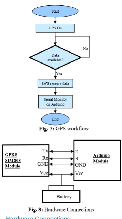
Fig. 7 shows the workflow of the GPS module. When the GPS module is switched on, it will continuously check for the available GPS strings provided by the satellite. Once the string is available, the GPS module will receive it and sends it to the Arduino. For that purpose, software serial library is used that provides a platform to use a baud rate other than 9600 which is fix for pin 0 and 1 of the Arduino. In order to get the GPS coordinates from the satellite, $GPGGA string command is used whose description is shown in Table 1.
Table 1. GPGGA String Description.
3.2 Hardware Connections
The hardware connection between GPRS SIM808 and Arduino module are shown in Fig. 8. The hardware implementation of the vehicle tracking system is shown in Fig. 9.
• Tx of GPRS connected to Pin 2 of Arduino
• Rx of GPRS connected to Pin 3 of Arduino
• The grounds of both modules are connected with
each other.
• Both modules are getting power supply from a
battery where GPRS/SIM808 is operated with 12 V and the Arduino is operated with 6 V
3.3 Flow Chart
In the software part of Fig. 10, it is shown that when a message is arrived, the message receiver module receives and stores it in a database. Additionally, the received coordinates are mapped on a Google map. If a user wants to check the previous route history, he enters the required information i.e., the date and the time for which he wants to check the history of the vehicle. After providing the required date and time, the route history will be mapped on a Google map.
As long as the user is using the application, the received
messages will be continuously mapped and
simultaneously will be saved in the database. However, if the user is logged out from the application, the process will stop.
4 Experimental Results
Android Studio provides a platform to develop applications for smart phones and also for windows. Android Studio is selected because it is easy to use and provides user friendly environment. Fig. 11 shows the graphical user interface (GUI) of the android based vehicle tracking system. Fig. 11(a) shows the welcome screen that will appear when the users click on the application icon in their mobile phones. Afterwards, the login screen will appear as shown in Fig. 11(b). The login screen is used to protect the data from unauthorized users and attackers. An authorized user must register itself before accessing the application. If the user is already registered, he enters the email and the password in order to login into the application. Otherwise, the user registers
main screen appears as shown in Fig. 11(d). When the user clicks on the current location button, the current location of the vehicle will be plotted on a google map with respect to the received coordinates from the hardware module as shown in Fig. 11(e). The message list button will list all the received messages that are stored in the database. The previous location button is used to display the previous history of the vehicle. For that purpose, the user provides the date, start time and the end time to map the previous route of the vehicle as shown in Fig. 11(f).
Conclusions
An android based vehicle tracking system is designed that could be installed on any vehicle to track its position. The system provides GPS coordinates to a mobile phone where these coordinates are mapped on a google map with the help of an android based application. The graphical user interface (GUI) of the application is user friendly where users can easily track their vehicles. The cost of the system is relatively very low which makes it a perfect choice for the customers to install it in their vehicles to make them secure.
Acknowledgments
This research project is funded by the Higher Education Commission (HEC) under Start-Up Research Grant Program (SRGP) No: 211108/SRGP/R&D/HEC/2016, date October 31st 2016
References
1. Sperling, D., Gordon, D.: Two Billion Cars: Driving Towards Sustainability. In: Oxford University Press, 2009. 2. Altaf, A., Khan, N.: Auto-theft: Over 80 cars, bikes stolen
in two months, Pakistan. In: The Express Tribune, 2016. 3. Rabbany, A.: Introduction to GPS: The Global Positioning
System.: Artech House, 2006.
4. Khan, A., Nam, J. C., Cho, Y.Z.: ACK-CAST: ACK-Based Broadcast Protocol for Vehicular Ad Hoc Networks. IEICE Transactions on Communications, Vol.E97-B, No.5, pp.960-966, May. 2014.
5. Khan, A., Cho, Y. Z.: BL-CAST: Beacon-Less Broadcast Protocol for Vehicular Ad Hoc Networks. KSII Transactions on Internet & Information Systems, Vol.8, No.4, pp.1223-1236, April 2014.
6. Kum, D.W., Khan, A., Cho, Y. Z.: Traffic Density-Based Broadcast Scheme for Vehicular Ad Hoc Networks. IEICE Transactions on Communications, Vol.E95-B, No.12, pp.3875-3878, Dec. 2012.
7. Gu, G., Peng, G.: The survey of GSM wireless communication system. In: Proc. Of International Conference on Computer and Information Application (ICCIA), pp.121-124, Dec. 2010
8. Teng, C., Helps, R.: Mobile Application Development: Essential New Directions for IT. School of Technology, Brigham Young University, April, 2010.
9. Ullah, F., et al.: Control framework and services scenarios of provisioning N-Screen services in interactive digital signage. Tehnicki Vjesnik-Technical Gazette 21.6, pp. 1321-1329, 2014.
10.Ha, D.T., Pham, T.H., Khanh, N.D., Hoang, V.D.: Design and implementation of mobile vehicle monitoring system based on android smartphone. Third World Congress on Information and Communication Technologies (WICT 2013), Hanoi, pp. 51-56, 2013.
11.Alzahri, F.B.B., Sabudin, M.: Vehicle Tracking Device. In: International Conference On Advanced Informatics: Concepts, Theory And Application (ICAICTA), George Town, pp. 1-6, 2016.
12.Mohamad, O.A., Hameed, A.R., Ţăpuş, N.: Design and implementation of real time tracking system based on Arduino Intel Galileo. In: 8th International Conference on Electronics, Computers and Artificial Intelligence (ECAI), Ploiesti, pp. 1-6, 2016.