R E V I E W
Open Access
Response-based methods to measure road
surface irregularity: a state-of-the-art review
Teron Nguyen
1,2,3,4*, Bernhard Lechner
1and Yiik Diew Wong
2,3Abstract
Purpose:With the development of smart technologies, Internet of Things and inexpensive onboard sensors, many response-based methods to evaluate road surface conditions have emerged in the recent decade. Various
techniques and systems have been developed to measure road profiles and detect road anomalies for multiple purposes such as expedient maintenance of pavements and adaptive control of vehicle dynamics to improve ride comfort and ride handling. A holistic review of studies into modern response-based techniques for road pavement applications is found to be lacking. Herein, the focus of this article is threefold: to provide an overview of the state-of-the-art response-based methods, to highlight key differences between methods and thereby to propose key focus areas for future research.
Methods:Available articles regarding response-based methods to measure road surface condition were collected mainly from“Scopus”database and partially from“Google Scholar”. The search period is limited to the recent 15 years. Among the 130 reviewed documents, 37% are for road profile reconstruction, 39% for pothole detection and the remaining 24% for roughness index estimation.
Results:The results show that machine-learning techniques/data-driven methods have been used intensively with promising results but the disadvantages on data dependence have limited its application in some instances as compared to analytical/data processing methods. Recent algorithms to reconstruct/estimate road profiles are based mainly on passive suspension and quarter-vehicle-model, utilise fewer key parameters, being independent on speed variation and less computation for real-time/online applications. On the other hand, algorithms for pothole
detection and road roughness index estimation are increasingly focusing on GPS accuracy, data aggregation and crowdsourcing platform for large-scale application. However, a novel and comprehensive system that is comparable to existing International Roughness Index and conventional Pavement Management System is still lacking.
Keywords:Road profile, Pothole detection, Road roughness, Accelerometer, Estimation, Classification
1 Introduction
A rough road gives poor ride quality, increases vehicle fuel consumption and affects vehicle handling. Accord-ing to a report in Britain, potholes caused more than £1 million damages to vehicles every day in 2010 [1]. Road roughness measurement is vital for transport authorities in the quest to maintain adequate ride quality for vehi-cles. Knowledge of road profiles also provides informa-tion for adjusting control parameters to improve ride
comfort and ride handling, given the development of suspension system from passive to semi-active and active control in the automotive technology.
Generally speaking, road estimation algorithms [2] can be divided into three distinct types, namely contact measurement, non-contact measurement, and system response-based estimation. Conventional contact and non-contact measurements have been used worldwide as major pavement profiling methods. The primary contact measurement includes two categories: manual profilo-graph such as rods and levels, straight edges, walking profilers, and trailer-towed devices such as the Longitu-dinal Profile Analyser (LPA). Non-contact measurement includes inertial profilers such as the GM profilometer developed by General Motors (GM), and the Automated
© The Author(s). 2019Open AccessThis article is distributed under the terms of the Creative Commons Attribution 4.0 International License (http://creativecommons.org/licenses/by/4.0/), which permits unrestricted use, distribution, and reproduction in any medium, provided you give appropriate credit to the original author(s) and the source, provide a link to the Creative Commons license, and indicate if changes were made.
* Correspondence:[email protected];[email protected] 1
Institute of Road, Railway and Airfield Construction, Technische Universität München, Baumbachstraße 7, 81245 Munich, Germany
2TUMCREATE Ltd, 1 Create Way, #10-02 CREATE Tower, Singapore 138602,
Singapore
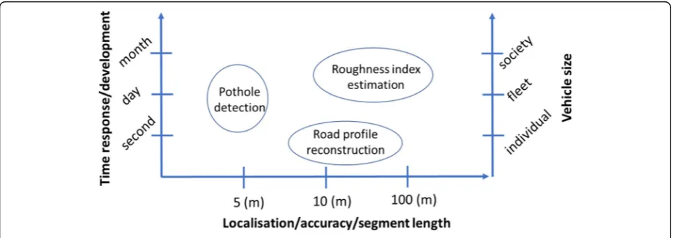
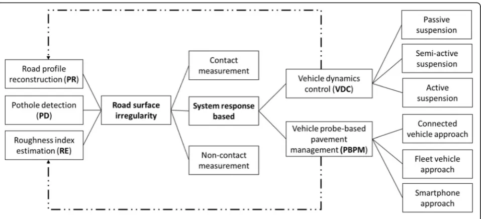
Pavement Profiler (APP). The advantages and disadvan-tages of these contact and non-contact measurements are discussed in [3–6]. In recent years, road surface monitoring instruments have transcended from dedi-cated vehicles with special sensors to dedidedi-cated sensors mounted on public transport vehicles, and general-purpose sensors on privately-owned vehicles, and most recently, smartphone-enabled automated monitoring of road infrastructure [7]. This development is driven by response-based methods to indirectly assess road rough-ness condition using measurements of displacements, velocities, and accelerations of vehicle components, resulting in cost reduction for labour and equipment as compared with direct contact/non-contact profiling [8]. This has led to the emergence of Probe Data Perform-ance Management (PDPM) or Vehicle Probe-based Pavement Management (PBPM) for assessing pavement quality through probe data [9]. There are three system structures by way of connected vehicle approach, fleet vehicle approach and smartphone approach. Basically, road excitation can be estimated using onboard sensors (accelerometers, gyroscopes) for individual or a combin-ation of three key functions as follows (see Fig.1):
1) RoadProfileReconstruction/estimation or road roughness classification -PR(e.g. Power Spectral Density–PSD), in which fast computation (e.g. in second) adapts vehicle parameters to road roughness levels;
2) PotholesDetection–PD, which detects potholes, manholes, road defects where the precise
localisation is of importance; and 3) Roughness IndexEstimation–RE(e.g.
International roughness index–IRI or new index) for pavement maintenance where roughness data is often aggregated for a certain segment length.
A brief overview of approaches using dedicated sensors and smartphone sensors can be found in [10, 11], yet a comprehensive review is lacking. Herein, in this literature review paper, around 130 articles have been reviewed fo-cusing on the methodologies but not on theories, empirical insights or conceptual model [12]. The objectives and con-tribution of this review are threefold. Firstly, an examin-ation of the state-of-the-art response-based methods is conducted to provide an overview of their developments within the last 10 years. This provides a comprehensive un-derstanding of the diversity of on-going and dominant methodologies being used. Secondly, the key pros and cons of different methods, e.g. signal processing, data-driven, threshold-based, transfer function, are highlighted. Lastly, key focus areas on the estimation of road surface irregular-ity are proposed as opportunities for further studies such as the inclusion of air-suspension system, improvement of current machine learning algorithms or further develop-ment of the fleet vehicle approach. The results of this re-view serve to shed light and provide orientation for the research community on system response-based estimation.
Figure2 illustrates a topology of approaches to meas-ure road surface irregularity focusing on system response-based methods with detailed applications for vehicle dynamics control (VDC) in dealing with PR for adjusting vehicle parameters to improve ride comfort and ride handling; and PBPM utilising portable onboard sensors and smartphones for PD and RE in citywide network.
The methodology for gathering “response-based methods literature database” is presented in the next section. PR algorithms for VDC are then described, followed by PD and RE algorithms for PBPM. The dis-cussion, conclusion and outlook section reports the main results of this review study and proposes research and development gaps deserving of further study.
2 Literature data retrieval method
Available articles regarding response-based methods to measure road surface condition were collected mainly from “Scopus” database [13] and partially from
“Google Scholar” [14]. Articles of focus are those pub-lished by international journals and high-quality con-ferences. The first round of online search was conducted using the following keywords: ((“road roughness” OR “road profile” OR “pothole”) AND (ac-celerometer OR response) AND (estimation OR classifi-cation OR detection)) AND PUBYEAR > 2005, using Scopus’ default search settings: article titles, abstracts and/or keywords. The search period is limited to the recent 15 years since an initial investigation found that studies on the topics mostly started at around 2006, with predominant numbers in the past 10 years (see Fig. 3b).
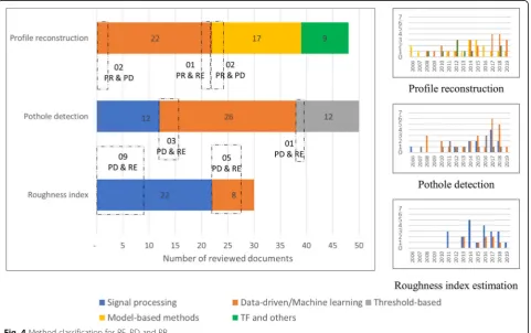
A total of 161 documents were obtained from the vari-ous field of studies, of which 86 are published journal ar-ticles, 3 are articles in press, 1 is a book chapter and 71 are conference papers. All retrieved documents were fur-ther analysed in which 87 documents were removed as be-ing insufficiently related to the main scope of VDC or PBPM nor the main functionalities of system response-based estimation (PR, PD or RE); these rejected docu-ments are mostly related to bridge-vehicle interaction. Relevant references (56) were retrieved and included in the analysis (see Fig.3a). The additional literature that was missed in the direct search is due to various technical terms being used in these documents such as road anom-aly, abnormal section, impact, defect, bump, irregularity, failure, damage (instead of‘pothole’) or sensing, measure-ment (instead of estimation, classification, detection). Among the 130 reviewed documents, 37% are for road Fig. 2Classification of different approaches to measure road surface irregularity under three main functions
profile reconstruction, 39% for pothole detection and the remaining 24% for roughness index estimation.
3 Results
3.1 Road profile reconstruction/estimation for vehicles dynamics control
Profile reconstruction/estimation (PR) is essential for ve-hicle dynamics control (VDC). However, control algo-rithms are dependent on vehicle suspension types, be it passive, semi-active or active, to formulate the corrective dynamics behaviours [15]. PR algorithms for VDC can be classified into three main approaches: 1) model-based methods or observers/estimators, 2) data-driven methods/ machine-learning techniques, and 3) frequency response functions/transfer functions and others. These are de-scribed in the following sections.
3.1.1 Model-based methods (observers/estimators)
Kalman filter/estimator (KF) and sliding mode observer (SM) are the most commonly-used methods since a long time. Three standard KFs are the linear KF for linear cases, the extended KF for a non-linear relationship, and the unscented KF for strong nonlinearities. Initially in 2011, the linear quarter-car model was developed to im-plement the KF method [16] that needed measurements of the suspension deflections, the body position and accel-eration. In [17], an improved KF was developed to include the vehicle sprung mass change, and in [18] an augmented KF was developed to make use of all the available sensors. The PR is implemented with the modified KF framework in [19] for the non-linear spring-damper system to localise autonomous vehicle position. Unfortunately, for all KF methods, the tuning of the covariance matrix is usually done heuristically which effects the estimation results caused by the deterioration and loss of information. To overcome this drawback, an algebraic estimator was devel-oped in [20], by updating the covariance matrix according to the change of road roughness [21], or by applying the adaptive KF and adaptive super-twisting observer (AKF-ASTO) algorithm in a new estimator [22].
Regarding otherobserverapproaches, the most common method is the sliding mode observer (SM) considering the road profile as unknown inputs to be estimated. A 16-DOF full-car model was firstly used to develop the SM based on the vertical motion of the vehicle [5]. A re-searcher [23] then developed a second-order SM to avoid the assumption of constant velocity, while another model-based observer was developed to compensate for the chas-sis dynamics for minimising its interaction effect [6]. The higher-order SMs using adaptive super-twisting observer based on a nonlinear quarter-car model were also devel-oped in [24] for PR, and in [25] for PR and tyre friction es-timation simultaneously. The combination of sliding mode observer and adaptive Kalman filter for PR related
to tyre dynamics can be found for active suspension con-trol in [26]. Other methods of control theory using an adaptive observer with the Q-parameterisation method have shown their validity and feasibility [27] and the ex-tensions in [28,29] with detailed synthesis and experimen-tal validation. Compared to other methods such as KF, the Q-parametrization method provides better performance and is suitable for real-time implementation due to less computing cost and implementation complexity.
Another state observer can be found in [30] to use the overall response of the preceding vehicle(s) to generate preview controller information for follower vehicles. An H∞ observer was adopted and found to be feasible for real-time implementation but required knowledge of many vehicle parameters [31], while a jump-diffusion process estimator can perform PD and PR simultan-eously [32]. Although these types of estimators can work effectively for active suspension system control, exten-sive modelling is required as the main drawback as well as the problem of speed variation.
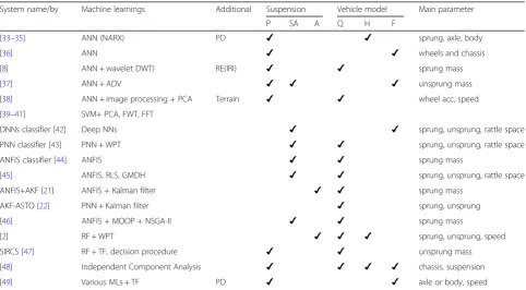
3.1.2 Data-driven methods/machine-learning techniques
The emergence of machine-learning techniques (MLs) has motivated researchers to focus on various ML algo-rithms to measure road surface irregularity, as reported in more than half of the reviewed documents. Among them, Neural Network (NN)/Artificial Neural Network (ANN) and Support Vector Machine (SVM) are the most common methods. In 2010, a study [33] used a Bayesian-regularised nonlinear autoregressive exogenous model (NARX) for PR based on the acceleration from a linear half-vehicle model. The ANN-based methodology has been applied for road surface condition identification on mining vehicles and mining roads [34], and for the Land Rover Defender 110 [35]. Similar ANN can be found in [36] using seven vehicle acceleration variables as inputs. To improve estimation efficiency, different techniques/al-gorithms have been implemented along with ANN. In [8], wavelet analysis was included in similar ANN for the con-nected vehicle environment. In [37], ANN was used with the mean square of unsprung mass acceleration divided by vehicle speed to classify road Power Spectral Density (PSD) regardless of vehicle speed and suspension parameters.
To classify different road types/terrains (e.g. brick, gravel, grass), ANN and principal component analysis (PCA) were used in combination with image processing [38], or SVM with PCA [39]. To remove the speed de-pendence from terrain classification, SVM was combined with wavelet analysis of acceleration data [40], or SVM with spatial frequency component analysis by Fast Fou-rier Transform [41].
VDC. Deep Neural Networks [42] and Probabilistic Neural Network classifier [43] were proposed by using measurable system responses. The Adaptive Neuro-Fuzzy Inference Sys-tem - ANFIS road classification method was proposed using wavelet analysis based solely on sprung mass acceleration [44]. ANFIS classifier was found to be better than other methods in [45], and ANFIS was combined with KF for VDC of semi-active suspension in [21, 46]. PNN classifier using wavelet analysis showed better performance than ANFIS and NARX methods. The combination with PNN classifier and AKF-ASTO [22] adaptively changes the process noise covariances Q and R for the KF, resulted in higher accuracy than existing KF method. Random forest classifier (RF) was used to combine information from both time and frequency domains for a controllable suspension system in [2], while the RF was combined with transfer function to develop a speed independent road classification strategy in [47]. Most recently, independent component ana-lysis as a simple and fast method was developed in [48], and various MLs were compared in [49].
3.1.3 Transfer functions and other techniques
The transfer function(TF) was first used by Gonzalez in 2008 [50] to estimate road PSD based on the relation-ship between the road surface and vehicle acceleration via a TF as Eq.1:
Hð Þ ¼Ω PSDaccð ÞΩ =PSDroadð ÞΩ ð1Þ
where PSDacc(Ω) and PSDroad(Ω) are the PSD for a fre-quency Ωdue to vehicle accelerations and road profile, respectively.
The road can be classified according to ISO 8608 [51] based on PSDroad estimated from the PSDaccof the axle
or body acceleration measurements [50]. In [52], similar results have confirmed the efficiency of the TF approach, and in [53] the TF was extended to a full-vehicle model to estimate road PSD regardless of vehicle speeds. From another point of view, dynamic tyre pressure sensor was used to estimate road profiles based on an assumption of a linear relationship between road surface profiles and tyre pressure via a TF [54].
Regarding other methods, a numerical optimisation technique can be found in [55] that employs Monte Carlo simulations to obtain the optimal PR, but it is costly for computing. The method of control-constraints was proposed [56] that focuses on tyre dynamics and re-quires solving differential-algebraic equations. A modu-lating function technique [57] can fulfil the real-time and noise suppression requirements with the focus par-ticularly on off-road vehicles. In [58], Bayesian estimator was proposed regardless of vehicle models; but a priori information of the road is required. In addition to accel-eration measurements, PR can be done by microphones
to measure tyre noise [59]; however, a robustness study is needed to reduce signal contaminations.
3.1.4 Summary of methods for road profile reconstruction/ estimation
Table 1 lists the related model-based methods where most of them use a passive suspension system and quarter-vehicle model while fewer use active suspen-sion system. Q-parameterisation has demonstrated its better performance than other methods, with less par-ameter information required after experimental valid-ation using passive, semi-active and active suspension systems. The pothole detection does not gain much research interest with only 2 relevant studies. Studies on data-driven methods are listed in Table 2 and similarly most studies use a passive suspension system and quarter-vehicle model. Together with road profile reconstruction, the functions of pothole detection (2 studies), roughness index estimation (1 study) or ter-rain classification (4 studies in which 3 are from the same first author) can be found. Since the first ML emerging from NARX in 2010, recent research con-tinues to improve the algorithms by increasing esti-mation accuracy and using less parameter inforesti-mation such as the ANFIS (only sprung mass). Research re-lated to speed independence has shown the potential for large-scale application with both offline-online phase clas-sification steps such as the speed independent road classi-fication strategy - SIRCS. Studies ontransfer function and other methodsare listed in Table3for road profile recon-struction only without consideration of pothole detection or roughness index estimation, in which all the algorithms were developed using the passive suspension system. The sophisticated modelling of other methods has negated them from the real-time or online application.
Table 1Summary of model-based methods for road profile reconstruction function
System name/ by
Model-based approach Additional Suspension Vehicle
model
Main parameter
P SA A Q H F
[16] KF ✔ ✔ body position and acc, suspension def
[17] improved KF ✔ ✔ sprung acc, suspension def
[18] augmented KF ✔ ✔ ✔ suspension dis, unsprung, sprung acc
[19] modified KF ✔ ✔ ✔ ✔ ✔ vertical dis of the tire-road contact points, longitudinal acc
[5,23] SM, second-order SM ✔ ✔ wheels and chassis
[6] SM PD ✔ ✔ chassis
[24] higher-order SM ✔ ✔ sprung mass dis and velocity
[25] higher-order SM Tyre ✔ random road profile, the longitudinal friction force, and the
engine friction
[26] SM + AKF Tyre ✔ ✔ spring def, wheel acc, tire road contact acc
[27] Q-parametrization ✔ ✔ sprung mass position
[28] Q-parametrization ✔ ✔(1/
5)
[29] Q-parametrization ✔ ✔
[20,30] Algebraic estimator, state
observer ✔ ✔
sprung mass and unsprung mass vertical dis, suspension def
[31] H∞observer ✔ ✔(1/
5)
sprung acc, suspension def, unsprung mass motion
[32] Jump-diffusion estimator PD ✔ ✔ wheel excitation
Table 2Summary of data-driven methods for road profile reconstruction function
System name/by Machine learnings Additional Suspension Vehicle model Main parameter
P SA A Q H F
[33–35] ANN (NARX) PD ✔ ✔ sprung, axle, body
[36] ANN ✔ ✔ wheels and chassis
[8] ANN + wavelet DWT) RE(IRI) ✔ ✔ sprung mass
[37] ANN + ADV ✔ ✔ ✔ unsprung mass
[38] ANN + image processing + PCA Terrain ✔ ✔ wheel acc, speed
[39–41] SVM+ PCA, FWT, FFT
DNNs classifier [42] Deep NNs ✔ ✔ sprung, unsprung, rattle space
PNN classifier [43] PNN + WPT ✔ ✔ sprung, unsprung, rattle space
ANFIS classifier [44] ANFIS ✔ ✔ sprung mass
[45] ANFIS, RLS, GMDH ✔ ✔ sprung, unsprung, rattle space
ANFIS+AKF [21] ANFIS + Kalman filter ✔ ✔ sprung mass
AKF-ASTO [22] PNN + Kalman filter ✔ sprung, unsprung
[46] ANFIS + MOOP + NSGA-II ✔ ✔ sprung mass
[2] RF + WPT ✔ ✔ ✔ sprung, unsprung, speed
SIRCS [47] RF + TF, decision procedure ✔ ✔ unsprung mass
[48] Independent Component Analysis ✔ ✔ ✔ ✔ chassis, suspension
[49] Various MLs + TF PD ✔ ✔ axle or body, speed
PCA, WPD, WPT, DWT, FWT: Principal Component Analysis, Wavelet Package Decomposition, Wavelet Package Transformation, Discrete Wavelet Transform, Fast Wavelet Transform.
3.2 Pothole detection and roughness index estimation The three approaches in PBPM has been classified as: con-nected vehicle approach (uses OEM-installed accelerome-ters, sensor hardware and standardised onboard vehicle) fleet vehicle approach (uses semi-permanent, non-stock ac-celerometers in a fleet of agency-owned vehicles, supple-mented by GPS units) and mobile device approach (uses accelerometer-equipped mobile devices to gather and transmit roughness information to a central database) [9]. The latter approach using smartphone sensors as the con-cept of“citizen as sensors”in [60] or“citizen engineer”[61] has received much research interest in recent years,
followed by the connected vehicle and the fleet vehicle (which can be grouped into one dedicated sensor onboard approach). Regardless of applications, the methodology can be classified into three groups: acceleration thresholds or threshold-based methods, signal processing and machine-learning techniques.
3.2.1 Threshold-based methods
Threshold-based methods are the most straightforward approaches for PD detection by processing mainly the vertical acceleration (Z-acc) or in combination with Table 3Summary of TF and other methods for road profile reconstruction function
System name/ by
TF and others Suspension Vehicle model Main parameter
P SA A Q H F
[50] TF ✔ ✔ axle or body
[52] TF ✔ ✔ unsprung mass acceleration
[54] TF ✔ tyre pressure
[53] TF + time span ✔ ✔ axle or body
[55] Cross-entropy ✔ ✔ sprung and unsprung acc
[56] Control-constraints ✔ ✔ tire dynamics
[58] Bayesian parameter rear wheel acc, veh response, speed
[59] Microphone ✔ ✔ tyre noise and axle acc
[57] Modulating function technique ✔ ✔ accelerometer, spring dis and orientation
other direction acceleration (x and y) and gyroscopes. A researcher [62] has proposed four indices in which the Z-THRESH was further modified [63] to build a cloud computing system: Z-THRESH (from vertical vibration), Z-DIFF (from the difference of consecutive Z-acc above threshold), STDEV(Z) (as the standard deviation of Z-acc above threshold in a window), and G-ZERO (whether the sensor senses a 0-G vibration). Similar STDEV(Z) can also be found in [64] and to develop a bump index in [65]. Other acceleration thresholds are used to classify three relative rough road levels [66] or severity levels of potholes [67, 68] and to characterise road bumps [69]. Thresholds of Z-acceleration and ultrasonic data were combined in [70] while the Z-jerk as the“rate of change of acceleration” is used in Cyber-physical system [71]. However, how to set up correct thresholds is challenging under the influence of vehicle speeds, suspension parameters as well as sensor location and orientation. Furthermore, only pothole detection alone is not sufficient for real application, as transport authorities care about roughness index estimation as well for road surface maintenance.
3.2.2 Signal processing
To overcome the drawbacks of the threshold-based methods, various signal processing filters have been used. Researcher [72] further processed Z-acc by simple filters and Gaussian model-based algorithm to detect the severity of potholes and differentiate humps and potholes. A study in [73] combined Z-THRESH and G-ZERO and adopted a spatial interpolation method to obtain precisely pothole lo-cations. Fuzzy logic was used to detect and recognise the speed bumps from vehicle speed and Z-acc variance [74]. Time-frequency analysis was used such as the Discrete Wavelet Transform to estimate gravel roads ride quality, detect the location and the severity of surface potholes [75], or the Gabor transform to estimate road roughness condi-tion in combinacondi-tion with image processing for PD [76]. In [77], a greedy heuristic approach for an optimal mobile sen-sor placement maximises the total length of the road inspected by sensors.
Frequency filter, speed filter and small peaks filter were used to develop the vertical acceleration impulse that cor-responds to a “high-energy event”on the road surface in UNIquALroad [78,79]. Dynamic Time Warping –DTW detects pothole by using the pattern-matching technique independent of time and speed [80]. Similar to DTW, the Smartphone Probe Car system was developed using a new road anomaly indexing heuristic which is adaptive to ve-hicle dynamics [81].
To evaluate road roughness IRI, the well-known regres-sion relationships between PSD with IRI was investigated in [82,83], so do the root-mean-squared acceleration (RMS) and IRI in [84,85]. A compact road profiler and ArcGIS to
measure and evaluate road roughness condition was intro-duced in [86]. Filter and Fast Fourier Transform (FFT) were used to estimate IRI from smartphone data under realistic setting (e.g. inside pockets) based on the approximate pro-portion of spectrum magnitude and road IRI [87,88]. The inverse pseudo-excitation method offers a new approach to estimate IRI independent of the travelling speed, road roughness grade, and vehicle type [89]. The RMS acceler-ation was further studied to detect potholes using speed fil-ter and Z-axis filfil-ter in Pothole Patrol, and to develop new roughness index (IRI-proxy) depicting overall road quality [60]. Based on the relationship of PSD between road surface and vertical acceleration, parameters of road profile can be evaluated using Maximum Likelihood-based estimation [90], or using linear predictive coding by averaging the power of the prediction error [91, 92]. In [93], a recursive multiscale Correlation-Averaging algorithm was developed to deal with the uncertainty/noise such as GPS inaccur-acies, driving path variation and errors from the distance-measuring devices.
Regarding new roughness index, a speed-independent road impact factor - RIF (individual vehicle) and its corre-sponding time-wavelength-intensity-transform–TWIT (ve-hicle groups) for connected ve(ve-hicles were established using advanced signal processing in [94]. Further studies were conducted intensively to investigate and validate the RIF re-garding sampling rate selection [95], localisation [96, 97], RIF-IRI proportionality [98], deterioration forecasts in con-sideration of suspension parameter variances [99], stop-and-go conditions [100], and wavelength sensitivity [101].
3.2.3 Machine learning techniques
instrumented with smartphones embedded with the K-Nearest-Neighbour and Naive Bayes algorithm.
Among MLs, support vector machine (SVM) is used most frequently, and it is often combined with feature extraction methods as multiple classifiers. In [114], SVM was used to detect road anomalies by processing the data collected from a motorcycle-mounted tri-axial ac-celerometer and further classify road surface condition using unsupervised ML. Recently, SVM and Dynamic Time Warping algorithm were developed in [115] to identify aggressive driving events, road bumps and pot-holes for cycling. Another improvement was included in [116] where the gyroscope around gravity rotation was used. SVM and wavelet analysis were also used in RoADS [117] to classify the road anomaly into three event classes: severe, mild and span, and in [118] to de-tect road anomaly based on driver attitudes toward the speeds and turnings. SVM and Fast Fourier Transform-ation were used in [119] to remove the speed depend-ence and to label road anomaly. Another study in [120] combined SVM and Wavelet Package Decomposition to detect potholes with low computing cost. In Wolverine [121], the smartphone accelerometer data is used to de-tect braking events and bumps using K-means clustering and SVM. In [122, 123], SVM was trained using exten-sive data set from CarSim vehicle simulation as well as experiment, applying for under-sampled vehicles sensor problems and multi-lane pothole detection. In [124], a virtual road network inspector was built based on SVMs to detect potholes using accelerometers mounted to the front and rear axles of the buses.
The comparison of different MLs was conducted in several studies to find the best ML. In [125], a data mining approach was developed to compare the per-formance of five algorithms for PD. By adopting the framework of this study, a study [126] used RF for its best performance to develop a cloud-based Road Anomaly Service architecture in which PCA was used for feature extraction. PCA was also used in [127, 128] after NN and RF classification were com-pared to develop a street defect classifier to select NN for its better performance. RMS thresholds were set as a triggering condition for data logging condi-tion and a new street defect level (from 0 to 1) to evaluate the road segment condition. In RoadSense [129], Decision Tree (DT) was designed and com-pared with SVM and Naïve Bayes algorithm after feature extraction. In Pothole lab [130], a new SVM(Z) and Swarm indices were developed to com-pare with the four thresholds in [62], Nericell, Pot-hole Patrol, and PERT [119]. Backward feature elimination was used in [131] to select the optimal set of features for different classification models while in [132] the forward selection and backwards
elimination process was performed showing better performance than existing approaches.
Besides CRSM system for IRI estimation, MLs were used in [133] where the authors used smartphone sensor data for training a feature-based prediction model and compared with the road condition from official IRI mea-surements of the road surface. Another researcher [134] applied NARX ANN to estimate IRI from the connected vehicle after investigating vehicle suspension characteris-tics and its speed in [8]. In [7], the mean-absolute-value of the Z-acc for every 100 m was sensed by a smart-phone on a motorbike, and a fuzzy classifier from a ser-ver was used for RE.
3.2.4 Summary of methods for pothole detection and road roughness estimation
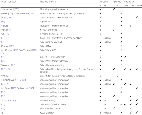
Studies onthreshold-based methodsare listed in Table4. Given the simplicity of this method based on true posi-tive and false posiposi-tive of the detection rate, the threshold values may vary due to different factors which make this method not being feasible to be used in real scenarios and large-scale implementation. Table5 lists the studies on signal processing methods, in which not only the methods of accurate PD and RE but also further con-cerns on GPS data noise/inaccuracy, sensor and smart-phone installation/direction, data fusion/aggregation and crowdsensing system/platform were considered. Among them, the adaptive thresholds in Smartphone Probe Car and Smart patrolling, as well as the IRI-proxy, Smar-tRoadSense and UNIquaALroad system are found to be promising for large scale application. RIF and TWIT are also potential replacements of IRI in the context of con-nected vehicle environments. As forML methods recent studies are listed in Table 6. MLs have attracted many studies resulting in high performance in which PCA plays an important role in feature extraction for the training process. CRSM [109, 110], the system in [122, 123] and another in [133] are promising systems for large scale application.
and 8/30 (27%) for the new roughness index (RIF and TWIT). There are only 6 studies (7%) related to fleet vehicle approach, 23 studies for the connected ve-hicle (28%) and 53 studies for smartphone approach (65%). The problems of GPS accuracy, data aggrega-tion and crowdsourcing have been considered in many studies using signal processing (9/21 studies)
and ML (13/30 studies), aiming at supporting the emergence of crowdsourcing-based road surface monitoring.
4 Discussion, conclusion and outlook
Different methods present different levels of complexity, precision and computing intensiveness. Across all the Table 4Summary of threshold-based methods for pothole detection and roughness index estimation
System name/by Thresholds Function Approach
PD RE C F S
[62], [63] Z-thresh, Z-diff, Stdev(z), G-zero ✔ ✔
BusNet [64] std of filtered Z-acc ✔ ✔
Bump Recorder [65] Z-acc, bump index ✔ ✔
[66] Z-acc ✔ Relative ✔
Smart Pune [67] Z-acc, skid, accident, braking ✔ ✔
[68] Z-acc for severity levels ✔ ✔
[69] Z-acc pattern ✔ ✔
Cyber-physical system [71] Z-jerk ✔ ✔
[135] 0.1 g threshold ✔ ✔
PoDAS [70] Z-acc, ultrasonic ✔ ✔
Relative: Pothole-based roughness index.
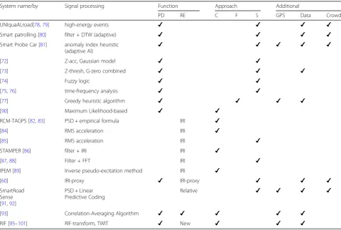
Table 5Summary of signal processing methods for pothole detection and roughness index estimation
System name/by Signal processing Function Approach Additional
PD RE C F S GPS Data Crowd
UNIquaALroad[78,79] high-energy events ✔ ✔ ✔ ✔
Smart patrolling [80] filter + DTW (adaptive) ✔ ✔ ✔ ✔
Smart Probe Car [81] anomaly index heuristic
(adaptive AI) ✔ ✔ ✔ ✔ ✔
[72] Z-acc, Gaussian model ✔ ✔
[73] Z-thresh, G-zero combined ✔ ✔ ✔
[74] Fuzzy logic ✔ ✔
[75,76] time-frequency analysis ✔ ✔
[77] Greedy heuristic algorithm ✔ ✔ ✔ ✔
[90] Maximum Likelihood-based ✔ ✔
RCM-TAGPS [82,83] PSD + empirical formula IRI ✔
[84] RMS acceleration IRI ✔
[85] RMS acceleration IRI ✔
STAMPER [86] filter + IRI IRI ✔
[87,88] Filter + FFT IRI ✔
IPEM [89] Inverse pseudo-excitation method IRI ✔
[60] IRI-proxy ✔ IRI-proxy ✔ ✔ ✔
SmartRoad Sense [91,92]
PSD + Linear Predictive Coding
Relative ✔ ✔ ✔ ✔
[93] Correlation-Averaging Algorithm ✔ ✔ ✔ ✔ ✔
reviewed documents and methods, it is recognised that data-driven methods/MLs are increasingly being used for all the functions in PR, PD and RE (see Fig. 4), as well as the usage of the passive suspension system and quarter-vehicle model due to their modelling simplifica-tion. Recent studies have shifted towards RE as shown in the time series graphs, in which signal processing tech-niques have been preferred for RE given the ability to achieve advanced functionalities such as adaptive thresh-olds or data fusion. Regarding the function of PR for the individual suspension system, it is more comprehensive to integrate PR for suspension control with variable un-certainty, but more challenges will occur on the know-ledge of vehicle dynamic characterisation. Whereas to deal with PD and RE for group of vehicles (fleet or con-nected vehicle) and“citizen sensor”concept in the large-scale society, the issues of GPS accuracy, data fusion
(e.g. the aggregation of sensor data or vehicle suspension types) and crowdsourcing will be challenges to the de-velopment of appropriate algorithms/systems. So far, several established algorithms/systems have solved these issues successfully.
In summary, the development of response-based methods to evaluate road surface irregularity has attracted research interests from both automotive technology and pavement engineering, aiming at the three main functions of Road profile reconstruction (PR), pothole detection (PD) and roughness index estimation (RE). The review of about 130 articles on this topic has revealed the diversity of recent approaches mostly within the recent decade. At first, the present study describes the algorithms used for PR including model-based methods, data-driven methods, transfer functions and others. Then, related algorithms for PD and RE are described including the threshold-based, Table 6Summary of ML methods for pothole detection and roughness index estimation
System name/by Machine learning Function Approach Additional
PD RE C F S GPS Data Crowd
Pothole Patrol [102] Clustering + training detector ✔ ✔
Nericell [103], TrafficSense [104,105] Z-peak method/ Clustering + training detector ✔ ✔
PRISM [106] Z-peak method + training detector ✔ ✔ ✔
[107] supervised ML ✔ ✔
P3[108] Clustering + training detector ✔ ✔ ✔
PADS [111] K-mean clustering ✔ ✔
BDS [112] K-means clustering + RF ✔ ✔
[113] Naive Bayes algorithm + K-nearest-neighbor Relative ✔
[114] SVM + unsupervised ML ✔ Relative ✔
D&Sense [115] SVM + DTW ✔ ✔ ✔
RoadMonitor [116], RoADS-based [117,
118]
SVM, SVM + SWT ✔ ✔
[119] SVM + FFT, cross validation ✔ ✔ ✔
[120] SVM + WPD, feature selection ✔ ✔
Wolverine [121] SVM + K-means clustering ✔ ✔
[122] [123] SVM + data filter, sliding window, greedy forward feature
selection ✔ ✔ ✔ ✔ ✔
VRNI [124] SVM + filter, moving window, feature extraction ✔ ✔
CRISP-DM-based [125,126] various algorithms comparison ✔ Relative ✔
[127,128] various algorithms comparison ✔ Relative ✔ ✔ ✔
RoadSense [129], Pothole Lab [130] various algorithms comparison ✔ ✔ ✔
[131] various algorithms comparison ✔ ✔
[132] various algorithms comparison ✔ ✔ ✔
CRSM [109,110] iGMM clustering ✔ IRI ✔ ✔ ✔
[133] SVM + WPD, Random forest IRI ✔ ✔ ✔ ✔
[134] ANN + feature selection IRI ✔ ✔
[7] Fuzzy classifier ✔ Relative ✔ ✔ ✔
Relative: Pothole-based roughness index;
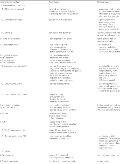
Table 7Advantages and disadvantages of response-based methods
Response-based methods Advantages Disadvantages
1. Road profile reconstruction
1.1. Model-based approach can deal with unforeseen
situations that are not included in the data-driven training datasets.
- an accurate model is required - not all required response
information is measurable - often only time domains
1.2 Kalman filter/estimator convenient, fast and simple - a priori information
about model errors - the tuning of the
covariance matrix is usually done heuristically
1.1.2 Observer can include tyre dynamics generally required knowledge
of many vehicle parameters
i. Sliding mode observer - convergence of the errors rather complicated for
practical application
ii. Q-parameterisation - less computing cost
and complexity for real-time implementation - better performance than KF
- the problem of extensive modelling - the sensitivity to speed
variation in almost methods
iii. Algebraic estimator iv. H∞observer v. State observer vi. Jump-diffusion
- can work effectively in the framework of the active suspension system - overcome the drawbacks of KF
1.2 Data-driven approach (MLs) - can use fewer parameters
(e.g. only sprung or unsprung mass) - various ML techniques to be applied - does not require excessive
system characterisation - required fewer analytical
skills than parametric model
- impractical for an online road estimation due to computationally costly training datasets (e.g. 4655 s are required to train the
ANN-based moded)
1.2.1 Only MLs (e.g. ANN) - able to detect potholes - spatial frequency only
- many vehicle parameters - not high accuracy and
sensitivity to speed variation
1.2.2 Combined MLs and others - higher accuracy
and performance - feasible for speed
independent classifiers
i. with feature selection (e.g. WPT, FFT, PCA)
- can combine both time and frequency domains - able to classify terrain conditions
further complex modelling and understanding vehicle dynamics control mechanism
ii. with KF determination of the
process noise variance before estimation
iii. with TF - speed independent
classifier with less training effort - able to detect potholes
1.3 Transfer function and others required fewer parameters
than the model-based approach
1.3.1 The transfer function (TF) - easy, convenient and fast
- frequency domain only
- not directly yield the expression of the excitation - limited to a constant speed (can be eliminated when combined TF with small time span)
1.3.2 Others
i. Cross-entropy using only sprung and
unsprung mass accelerations
too much computing time
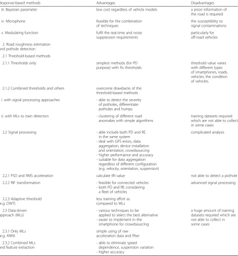
signal processing and machine-learning methods. Follow-ing this, all reviewed documents and discussion are sum-marised on their advantages and disadvantages (see Table7) which should be beneficial for further research in this field.
As for future research, it should be of strong value-add to focus on several potential topics as follows. Firstly, the air-suspension system (as an active-air-suspension type) has not been investigated by any research for PR whereas most
existing studies are about passive suspension system (67%). The reason is probably due to the high modelling complexity of the air-suspension while it is noted that the Macpherson controllable suspension was simulated and simplified in [2]. Secondly, MLs have demonstrated their capability for mul-tiple functions such as ANN algorithms for PR and PD in [33], PR and RE in [8,134] in which certain limitation in the estimation accuracy, vehicle parameters or speed variance can be further studied to develop comprehensive algorithms. Table 7Advantages and disadvantages of response-based methods(Continued)
Response-based methods Advantages Disadvantages
iii. Bayesian parameter low cost regardless of vehicle models a priori information of
the road is required
iv. Microphone feasible for the combination
of techniques
the susceptibility to signal contaminations
v. Modulating function fulfil the real-time and noise
suppression requirements
particularly for off-road vehicles
2. Road roughness estimation and pothole detection
2.1 Threshold-based methods
2.1.1 Thresholds only simplest methods (for PD
purpose) with fix thresholds
threshold value varies with different types of smartphones, roads, vehicles, the condition of vehicles.
2.1.2 Combined thresholds and others overcome drawbacks of the
threshold-based methods
i. with signal processing approaches - able to detect the severity
of potholes, differentiate potholes and humps
ii. with MLs to train detectors - clustering of different road
anomalies with simple algorithms
training datasets required which are not able to collect in some cases
2.2 Signal processing - able include both PD and RE
in the same system - deal with GPS errors, data
aggregation, device installation and orientation, crowdsourcing - higher performance and accuracy - suitable for data aggregation
regardless of different configuration (e.g. velocity, orientation, suspension)
complicated analysis
2.2.1 PSD and RMS acceleration calculate IRI value not able to detect a pothole
2.2.2 RIF transformation - feasible for connected vehicles
- both PD and RE considering a fleet of vehicles
advanced signal processing
2.2.3 Adaptive threshold (e.g. DWT)
less training effort as compared to MLs
2.3 Data-driven approach (MLs)
- various techniques to be
applied to select the best alternative - easier to implement in the
smartphone for crowdsourcing
a huge amount of training datasets required which are not able to collect in some cases
2.3.1 Only MLs (e.g. ANN)
simple using of raw acceleration data and filter
2.3.2 Combined MLs and feature extraction
Thirdly, although fleet vehicle approach seems to be less complicated to deal with, a comprehensive PBPM for PD and RE for the fleet of public transport (e.g. bus fleet) is still missing, except the general concept in [64] or smart PD in [124]. This fleet vehicle approach faces fewer challenges on data aggregation since vehicle fleets are quite identical, with lower GPS errors caused by lane-by-lane difference and without crowdsourcing plat-form. Such a system, once developed, will be beneficial in maintaining the road condition for public transport such as the citywide bus lane system in Singapore, London or worldwide BRT lane system, in which the road surfaces often deteriorate quickly due to heavy-loading from heavy-duty vehicles [136]. Fourthly, how to localise precise road roughness condition and potholes by lane accuracy (probably less than 0.5 m accuracy) is crucial to make the PBPM comparable to conventional Pavement management system, in which APP instru-ments currently measure road surface lane-by-lane. Higher GPS localisation of potholes also serves to opti-mise the trajectories of following vehicles in the con-nected platooning to avoid road defects by passing the vibration information from the leader to the followers. This can be done with the help of the future development of sensor technology. Lastly, the intensive on-going re-search on RIF and TWIT [95–101] as the alternatives for IRI in connected vehicle environment will be promising for large-scale implementation.
Abbreviations
acc, def, dis:Acceleration, deflection, displacement; ANFIS: Adaptive neuro-fuzzy inference system; APP: Automated pavement profiler; C, F,
S: Connected vehicle, Fleet vehicle, Smartphone approach; DNN: Deep neural networks; DOF: Degree-of-freedom; DTW: Dynamic time warping;
DWT: Discrete wavelet transforms; FFT: Fast Fourier transform; GPS, Data, Crowd: GPS accuracy, data fusion/aggregation, crowdsourcing platform; G-ZERO: The sensor senses a 0-g vibration; IRI: International roughness index; KF: Kalman filter; LPA: Longitudinal profile analyser; MLs: Machine-learning techniques; NARX: Bayesian-regularised nonlinear autoregressive exogenous model; NN/ANN: Neural network/artificial neural network; P, SA, A, tyre: Passive, semi-active, active suspension system, tyre dynamics; PBPM: Vehicle probe-based pavement management; PCA: Principal component analysis; PD: Pothole detection; PNN: Probabilistic neural network; PR: Road profile reconstruction/estimation or road roughness classification; PSD: Power spectral density; Q, H, F, 1/5: Quarter, half, full vehicle model, 1/5 vehicle model; RE: Roughness index estimation; RF: Random forest classifier; RIF: Road impact factor; SM: Sliding mode observer; STDEV(Z): The standard deviation of Z-acc above threshold in a window; SVM: Support vector machine; Ter: Terrain classification; TF: Transfer function; TWIT: Time-wavelength-intensity-transform; VDC: Vehicle dynamics control; Z-acc/ Z-thresh: Vertical acceleration/vertical threshold; Z-DIFF: The difference of consecutive Z-acc above threshold
Acknowledgements
This work is part of the PhD study of the first author and is financially supported by the National Research Foundation Singapore under its Campus for Research Excellence and Technological Enterprise (CREATE) programme. This work was supported by the German Research Foundation (DFG) and the Technical University of Munich (TUM) in the framework of the Open Access Publishing Program.
Authors’contributions
TN was the main initiator and author. His major contribution to the paper is as follows: study conceptualisation and design, data collection, analysis and interpretation of results, draft preparation. BL and YDW have also drafted the manuscript and made editings. All authors reviewed the results and approved the final version of the manuscript.
Funding
National Research Foundation Singapore (NRF).
Availability of data and materials Available articles from journal and conference.
Competing interests
The authors declare that they have no competing interests.
Author details
1Institute of Road, Railway and Airfield Construction, Technische Universität
München, Baumbachstraße 7, 81245 Munich, Germany.2TUMCREATE Ltd, 1
Create Way, #10-02 CREATE Tower, Singapore 138602, Singapore.3Centre for
Infrastructure System, Nanyang Technological University, N1-01b-51, 50 Nanyang Avenue, Singapore 639798, Singapore.4Faculty of Road and Bridge
Engineering, University of Science and Technology–The University of Danang, 54 Nguyen Luong Bang Street, Danang City, Lien Chieu District, Vietnam.
Received: 17 April 2019 Accepted: 6 September 2019
References
1. Daily Mail Online (2010) Potholes causing more than £1m damage to cars every day. https://www.dailymail.co.uk/news/article-1168103/Potholes-causing-1m-damage-cars-EVERY-day.html. Accessed 26 Mar 2019. 2. Qin, Y., Wei, C., Tang, X., Zhang, N., Dong, M., & Hu, C. (2018). A novel
nonlinear road profile classification approach for controllable suspension system: Simulation and experimental validation.Mechanical Systems and Signal Processing.https://doi.org/10.1016/j.ymssp.2018.07.015.
3. ASTM E1364–95. (2017).Standard test method for measuring road roughness by static level method. West Conshohocken: American Society for Testing and Materials.
4. Doumiati, M., Victorino, A., Charara, A., & Lechner, D. (2011).Estimation of road profile for vehicle dynamics motion: Experimental validation(pp. 5237– 5242). San Francisco: Proceedings of the American control conference. 5. Imine, H., Delanne, Y., & M’Sirdi, N. K. (2006). Road profile input estimation in
vehicle dynamics simulation.Vehicle System Dynamics, 44, 285–303.https:// doi.org/10.1080/00423110500333840.
6. McCann, R., & Nguyen, S. (2007). System identification for a model-based observer of a road roughness profiler. In2007 IEEE region 5 technical conference, TPS(pp. 336–343).
7. Kumar, R., Mukherjee, A., & Singh, V. P. (2017). Community sensor network for monitoring road roughness using smartphones.Journal of Computing in Civil Engineering, 31, 1–11.https://doi.org/10.1061/(ASCE)CP.1943-5487.0000624. 8. Zhang, Z., Sun, C., Bridgelall, R., & Sun, M. (2018). Road profile reconstruction
using connected vehicle responses and wavelet analysis.Journal of Terramechanics, 80, 21–30.https://doi.org/10.1016/j.jterra.2018.10.004. 9. Sauerwein, P. M., & Smith, B. L. (2011).Investigation of the implementation of
a probe-vehicle based pavement roughness estimation system. Charlottesville: Center for Transportation Studies.
10. Chugh, G., Bansal, D., & Sofat, S. (2014). Road condition detection using smartphone sensors: A survey.International Journal of Electronic and Electrical Engineering, 7, 595–602.
11. Wahlstrom, J., Skog, I., & Handel, P. (2017). Smartphone-based vehicle telematics: A ten-year anniversary.IEEE Transactions on Intelligent Transportation Systems, 18, 2802–2825.https://doi.org/10.1109/TITS.2017.2680468.
12. Van Wee, B., & Banister, D. (2016). How to write a literature review paper?
Transport Reviews, 36, 278–288.https://doi.org/10.1080/01441647.2015.1065456. 13. Burnham, J. F. (2006). Scopus database: A review.Biomedical Digital Libraries,
3, 1–8.https://doi.org/10.1186/1742-5581-3-1.
15. Tseng, H. E., & Hrovat, D. (2015). State of the art survey: Active and semi-active suspension control.Vehicle System Dynamics, 53, 1034–1062.https:// doi.org/10.1080/00423114.2015.1037313.
16. Doumiati, M., Victorino, A., Charara, A., & Lechner, D. (2011). Estimation of road profile for vehicle dynamics motion: Experimental validation. In
Proceedings of the 2011 American control conference(pp. 5237–5242).https:// doi.org/10.1109/ACC.2011.5991595.
17. Yu, W., Zhang, X., Guo, K., Karimi, H. R., Ma, F., & Zheng, F. (2013). Adaptive real-time estimation on road disturbances properties considering load variation via vehicle vertical dynamics.Mathematical Problems in Engineering, 2013, 1–9.https://doi.org/10.1155/2013/283528.
18. Fauriat, W., Mattrand, C., Gayton, N., Beakou, A., & Cembrzynski, T. (2016). Estimation of road profile variability from measured vehicle responses.Vehicle System Dynamics, 3114.https://doi.org/10.1080/00423114.2016.1145243. 19. Gim, J., & Ahn, C. (2018). Imu-based virtual road profile sensor for vehicle
localization.Sensors (Switzerland), 18.https://doi.org/10.3390/s18103344. 20. Haddar, M., Baslamisli, S. C., Chaari, R., Chaari, F., & Haddar, M. (2019). Road
profile identification with an algebraic estimator.Proceedings of the Institution of Mechanical Engineers, Part C: Journal of Mechanical Engineering Science, 233, 1139–1155.https://doi.org/10.1177/0954406218767470. 21. Wang, Z., Dong, M., Qin, Y., Du, Y., Zhao, F., & Gu, L. (2017). Suspension system state
estimation using adaptive Kalman filtering based on road classification.Vehicle System Dynamics, 55, 371–398.https://doi.org/10.1080/00423114.2016.1267374. 22. Qin, Y., Langari, R., Wang, Z., Xiang, C., & Dong, M. (2017). Road
profile estimation for semi-active suspension using an adaptive Kalman filter and an adaptive super-twisting observer. InProceedings of the American control conference(pp. 973–978).https://doi.org/10. 23919/ACC.2017.7963079.
23. Rabhi, A., M’sirdi, N. K., Fridman, L., & Delanne, Y. (2006). Second order sliding mode observer for estimation of road profile. InProceedings of the 2006 international workshop on variable structure systems(pp. 161–165). Alghero:VSS’06. 24. Rath, J. J., Veluvolu, K. C., & Defoort, M. (2014). Estimation of road profile for
suspension systems using adaptive super-twisting observer. In2014 European control conference, ECC(pp. 1675–1680).https://doi.org/10.1109/ECC.2014.6862248. 25. Rath, J. J., Member, S., Veluvolu, K. C., Member, S., & Defoort, M. (2015).
Simultaneous estimation of road profile and tire road friction for automotive vehicle.IEEE Transactions on Vehicular Technology, 64, 4461– 4471.https://doi.org/10.1109/TVT.2014.2373434.
26. Arat, M. A., Taheri, S., & Holweg, E. (2015). Road profile estimation for active suspension applications.SAE International Journal of Passenger Cars -Mechanical Systems, 8.https://doi.org/10.4271/2015-01-0651. 27. Doumiati, M., Erhart, S., Martinez, J., Sename, O., & Dugard, L. (2014).
Adaptive control scheme for road profile estimation: Application to vehicle dynamics. InProceedings of the 19th world congress the International Federation of Automatic Control(pp. 8445–8450). Cape Town: IFAC. 28. Tudón-martínez, J. C., Fergani, S., Sename, O., Martinez, J. J.,
Morales-menendez, R., & Dugard, L. (2015). Adaptive road profile estimation in semiactive car suspensions.IEEE Transactions on Control Systems Technology, 23, 2293–2305.https://doi.org/10.1109/TCST.2015.2413937.
29. Doumiati, M., Jairo, J., Molina, M., et al. (2017). Road profile estimation using an adaptive Youla- kučera parametric observer: Comparison to real profilers.
Control Engineering Practice, Elsevier, 61, 270–278.
30. Rahman, M., & Rideout, G. (2012). Using the lead vehicle as preview sensor in convoy vehicle active suspension control.Vehicle System Dynamics, 50, 1923–1948.https://doi.org/10.1080/00423114.2012.707801.
31. Tudon-Martinez, J. C., Fergani, S., Sename, O., Morales-Menendez, R., & Dugard, L. (2014).Online road profile estimation in automotive vehicles(pp. 2370–2375). Strasbourg: European control conference (ECC).
32. Li, Z., Kalabic, U. V., Kolmanovsky, I. V., Atkins, E. M., Lu, J., & Filev, D. P. (2016). Simultaneous road profile estimation and anomaly detection with an input observer and a jump diffusion process estimator. In
Proceedings of the American Control Conference, 2016-July(pp. 1693– 1698).https://doi.org/10.1109/ACC.2016.7525160.
33. Ngwangwa, H. M., Heyns, P. S., Labuschagne, F. J. J., & Kululanga, G. K. (2010). Reconstruction of road defects and road roughness classification using vehicle responses with artificial neural networks simulation.Journal of Terramechanics, 47, 97–111.https://doi.org/10.1016/j.jterra.2009.08.007. 34. Ngwangwa, H. M., & Heyns, P. S. (2014). Application of an ANN-based
methodology for road surface condition identification on mining vehicles and roads.Journal of Terramechanics, 53, 59–74.https://doi.org/ 10.1016/j.jterra.2014.03.006.
35. Ngwangwa, H. M., Heyns, P. S., Breytenbach, H. G. A., & Els, P. S. (2014). Reconstruction of road defects and road roughness classification using artificial neural networks simulation and vehicle dynamic responses: Application to experimental data.Journal of Terramechanics, 53, 1–18.
https://doi.org/10.1016/j.jterra.2014.03.002.
36. Yousefzadeh, M., Azadi, S., & Soltani, A. (2010). Road profile estimation using neural network algorithm.Journal of Mechanical Science and Technology, 24, 743–754.https://doi.org/10.1007/s12206-010-0113-1.
37. Li, Z., Yu, W., & Cui, X. (2018). Online classification of road roughness conditions with vehicle unsprung mass acceleration by sliding time window.Shock and Vibration, 2018.https://doi.org/10.1155/2018/5131434. 38. Wang, S., Kodagoda, S., Wang, Z., & Dissanayake, G. (2011).Multiple sensor
based terrain classification. Melbourne: Proceedings of the 2011 Australasian conference on robotics and automation.
39. Wang, S., Kodagoda, S., Shi, L., & Wang, H. (2017). Road-terrain classification for land vehicles: Employing an acceleration-based approach.IEEE Vehicular Technology Magazine, 12, 34–41.https://doi.org/10.1109/MVT.2017.2656949. 40. Wang, S., Khushaba, R., & Kodagoda, S. (2012).Towards speed-independent
road-type classification(pp. 614–619). Guangzhou: 2012 12th International Conference on Control, Automation, Robotics and Vision, ICARCV 2012. 41. Ward, C. C., & Iagnemma, K. (2009). Speed-independent vibration-based terrain classification for passenger vehicles.Vehicle System Dynamics, 47, 1095–1113.https://doi.org/10.1080/00423110802450193.
42. Qin, Y., Langari, R., Wang, Z., Xiang, C., & Dong, M. (2017). Road excitation classification for semi-active suspension system with deep neural networks.Journal of Intelligent Fuzzy Systems, 33, 1907–1918.https://doi.org/10.3233/JIFS-161860. 43. Qin, Y., Xiang, C., Wang, Z., & Dong, M. (2018). Road excitation
classification for semi-active suspension system based on system response.JVC/Journal of Vibration and Control, 24, 2732–2748.https:// doi.org/10.1177/1077546317693432.
44. Qin, Y., Dong, M., Zhao, F., Langari, R., & Gu, L. (2015). Road profile classification for vehicle semi-active suspension system based on adaptive neuro-fuzzy inference system. InProceedings of the IEEE conference on decision and control
(pp. 1533–1538). Osaka: Institute of Electrical and Electronics Engineers Inc. 45. Qin, Y., Langari, R., & Gu, L. (2014). The use of vehicle dynamic
response to estimate road profile input in time domain. InASME 2014 dynamic systems and control conference, DSCC 2014. San Antonio: American Society of Mechanical Engineers.
46. Qin, Y., Dong, M., Langari, R., Gu, L., & Guan, J. (2015). Adaptive hybrid control of vehicle semiactive suspension based on road profile estimation.
Shock and Vibration, 2015, 14–17.https://doi.org/10.1155/2015/636739. 47. Qin, Y., Wang, Z., Xiang, C., Hashemi, E., Khajepour, A., & Huang, Y. (2019).
Speed independent road classification strategy based on vehicle response: Theory and experimental validation.Mechanical Systems and Signal Processing, 117, 653–666.https://doi.org/10.1016/j.ymssp.2018.07.035. 48. Ben Hassen, D., Miladi, M., Abbes, M. S., Baslamisli, S. C., Chaari, F., & Haddar,
M. (2019). Road profile estimation using the dynamic responses of the full vehicle model.Applied Acoustics, 147, 87–99.https://doi.org/10.1016/j. apacoust.2017.12.007.
49. Gorges, C., Öztürk, K., & Liebich, R. (2019). Impact detection using a machine learning approach and experimental road roughness classification.
Mechanical Systems and Signal Processing, 117, 738–756.https://doi.org/10. 1016/j.ymssp.2018.07.043.
50. González, A., O’Brien, E. J., Li, Y. Y., & Cashell, K. (2008). The use of vehicle acceleration measurements to estimate road roughness.Vehicle System Dynamics, 46, 483–499.https://doi.org/10.1080/00423110701485050. 51. ISO8608:2016(en). (2016). Mechanical vibration road surface profiles
-reporting of measured data. InInternational Organization for Standardization. 52. Qin, Y., Guan, J., & Gu, L. (2012). The research of road profile estimation based
on acceleration measurement.Applied Mechanics and Materials, 226–228, 1614–1617.https://doi.org/10.4028/www.scientific.net/AMM.226-228.1614. 53. Gorges, C., Öztürk, K., & Liebich, R. (2018). Road classification for
two-wheeled vehicles.Vehicle System Dynamics, 56, 1289–1314.https://doi.org/ 10.1080/00423114.2017.1413197.
54. Wang, Q., McDaniel, J. G., Sun, N. X., & Wang, M. L. (2013).Road profile estimation of city roads using DTPS. San Diego: Proceedings of SPIE - The International Society for Optical Engineering.
55. Harris, N. K., Gonzalez, A., OBrien, E. J., & McGetrick, P. (2010).
56. Burger, M. (2014). Calculating road input data for vehicle simulation.Multibody System Dynamics, 31, 93–110.https://doi.org/10.1007/s11044-013-9380-9. 57. Noack, M., Botha, T., Hamersma, H. A., Ivanov, V., Reger, J., & Els, S. (2018).
Road profile estimation with modulation function based sensor fusion and series expansion for input reconstruction. InProceedings - 2018 IEEE 15th international workshop on advanced motion control, AMC 2018(pp. 547–552). Tokyo: Institute of Electrical and Electronics Engineers Inc.
58. Heyns, T., Heyns, P. S., & De Villiers, J. P. (2012). A method for real-time condition monitoring of haul roads based on bayesian parameter estimation.Journal of Terramechanics, 49, 103–113.https://doi.org/10.1016/j. jterra.2011.12.001.
59. Johnsson, R., & Odelius, J. (2012). Methods for road texture estimation using vehicle measurements. InProceedings of the international conference on noise and vibration engineering (ISMA 2012)(pp. 1573–1582).
60. Li, X., & Goldberg, D. W. (2018). Toward a mobile crowdsensing system for road surface assessment.Computers, Environment and Urban Systems, 69, 51–62.https://doi.org/10.1016/j.compenvurbsys.2017.12.005.
61. Harris, D. K., Alipour, M., Acton, S. T., Messeri, L. R., Vaccari, A., & Barnes, L. E. (2017). The citizen engineer: Urban infrastructure monitoring via crowd-sourced data analytics. In S. J.G. (Ed.),Structures congress 2017: Business, professional practice, education, research, and disaster management - selected papers from the structures congress 2017(pp. 495–510). Denver: American Society of Civil Engineers (ASCE). 62. Mednis, A., Strazdins, G., Zviedris, R., Kanonirs, G., & Selavo, L. (2011). Real
time pothole detection using android smartphones with accelerometers. In
2011 International conference on distributed computing in sensor systems and workshops. Barcelona: DCOSS’11.
63. Badurowicz, M., Cieplak, T., & Montusiewicz, J. (2016). The cloud computing stream analysis system for road artefacts detection.
Communications in Computer and Information Science, 608, 360–369.
https://doi.org/10.1007/978-3-319-39207-3_31.
64. De Zoysa, K. (2007). A public transport system based sensor network for road surface condition monitoring. InWorkshop on Networked System for Developing Regions. NSDR’07. New York, Kyoto: Association for Computer Machinery. 65. Yagi, K. (2010).Extensional smartphone probe for road bump detection(pp. 1–
10). Busan: 17th ITS world congress.
66. Nomura, T., & Shiraishi, Y. (2015). A method for estimating road surface conditions with a smartphone.International Journal of Informatics Society, 7, 29–36. 67. Limkar, S., Rajmane, O., Bhosale, A., & Rane, V. (2018). Small effort to build
Pune as a smart city: Smart real-time road condition detection and efficient management system.Smart Innovation, Systems and Technologies, 78, 609– 621.https://doi.org/10.1007/978-981-10-5547-8_63.
68. Rishiwal, V., & Khan, H. (2016). Automatic pothole and speed breaker detection using android system. In39th international convention on information and communication technology, electronics and microelectronics, MIPRO 2016 - proceedings(pp. 1270–1273). Opatija: Institute of Electrical and Electronics Engineers Inc..
69. Mukherjee, A., & Majhi, S. (2016). Characterisation of road bumps using smartphones.European Transport Research Review.https://doi.org/10. 1007/s12544-016-0200-1.
70. Mehta, J., Mathur, V., Agarwal, D., Sharma, A., & Prakasha, K. (2017). Pothole detection and analysis system (PODAS) for real time data using sensor networks.Journal of Engineering and Applied Sciences, 12, 3090–3097.https:// doi.org/10.3923/jeasci.2017.3090.3097.
71. Syed, B., Pal, A., Srinivasarengan, K., & Balamuralidhar, P. (2012). A smart transport application of cyber-physical systems: Road surface monitoring with mobile devices. InProceedings of the international conference on sensing technology, ICST(pp. 8–12).https://doi.org/10. 1109/ICSensT.2012.6461796.
72. Harikrishnan, P. M., & Varun, P. G. (2017). Vehicle vibration signal processing for road surface monitoring.IEEE Sensors Journal, 17, 5192–5197. 73. Wang, H.-W., Chen, C.-H., Cheng, D.-Y., Lin, C.-H., & Lo, C.-C. (2015). A
real-time pothole detection approach for intelligent transportation system.Mathematical Problems in Engineering, 2015.https://doi.org/10. 1155/2015/869627.
74. Aljaafreh, A., Alawasa, K., Alja’afreh, S., & Abadleh, A. (2017). Fuzzy inference system for speed bumps detection using smart phone accelerometer sensor.Journal of Telecommunication, Electronic and Computer Engineering, 9, 133–136.
75. Aleadelat, W., Wright, C. H. G., & Ksaibati, K. (2018). Estimation of gravel roads ride quality through an android-based smartphone.Transportation Research Record.https://doi.org/10.1177/0361198118758693.
76. Grabowski, D., Szczodrak, M., & Czyzewski, A. (2018). Economical methods for measuring road surface roughness.Metrology and Measurement Systems, 25, 533–549.https://doi.org/10.24425/123905.
77. Ali, J., & Dyo, V. (2017). Coverage and mobile sensor placement for vehicles on predetermined routes: A greedy heuristic approach. InICETE 2017 -proceedings of the 14th international joint conference on e-business and telecommunications(pp. 83–88).
78. Astarita, V., Caruso, M. V., Danieli, G., Festa, D. C., Giofrè, V. P., Iuele, T., & Vaiana, R. (2012). A mobile application for road surface quality control: UNIquALroad.Procedia - Social and Behavioral Sciences.https://doi.org/10. 1016/j.sbspro.2012.09.828.
79. Vittorio, A., Rosolino, V., Teresa, I., Vittoria, C. M., & Vincenzo, P. G. (2014). Automated sensing system for monitoring of road surface quality by mobile devices.Procedia-Social and Behavioral Sciences. (pp. 111, 242-251). 80. Singh, G., Bansal, D., Sofat, S., & Aggarwal, N. (2017). Smart patrolling: An
efficient road surface monitoring using smartphone sensors and crowdsourcing.Pervasive and Mobile Computing, 40, 71–88.https://doi.org/ 10.1016/j.pmcj.2017.06.002.
81. Yi, C.-W., Chuang, Y.-T., & Nian, C.-S. (2015). Toward crowdsourcing-based road pavement monitoring by mobile sensing technologies.IEEE Transactions on Intelligent Transportation Systems, 16, 1905–1917.https://doi. org/10.1109/TITS.2014.2378511.
82. Chen, K., Lu, M., Fan, X., Wei, M., & Wu, J. (2011). Road condition monitoring using on-board three-axis accelerometer and GPS sensor. InInternational ICST conference on communications and networking. China (pp. 1032–1037). 83. Du, Y., Liu, C., Wu, D., & Jiang, S. (2014). Measurement of international
roughness index by using Z-axis accelerometers and GPS. InMathematical Problems in Engineering, 2014.https://doi.org/10.1155/2014/928980. 84. Dawkins, J., Bevly, D., Powell, B., & Bishop, R. (2011).Investigation of
pavement maintenance applications of Intellidrive. University of Virginia Technical Report: Center for Transportation Studies, University of Virginia. 85. Zeng, H., Park, H., Smith, B. L., & Parkany, E. (2018). Feasibility assessment of a smartphone-based application to estimate road roughness.KSCE Journal of Civil Engineering, 22, 3120–3129.https://doi.org/10.1007/s12205-017-1008-9. 86. Abulizi, N., Kawamura, A., Tomiyama, K., & Shun, F. (2016). Measuring and evaluating of road roughness conditions with a compact road profiler and ArcGIS.Journal of Traffic and Transportation Engineering (English Edition), 3, 398–411.https://doi.org/10.1016/j.jtte.2016.09.004.
87. Douangphachanh, V., & Oneyama, H. (2014). A study on the use of smartphones under realistic settings to estimate road roughness condition.
EURASIP Journal on Wireless Communications and Networking, 2014, 1–11. 88. Douangphachanh, V., & Oneyama, H. (2013). A study on the use of
smartphones for road roughness condition estimation.Journal of the Eastern Asia Society for Transportation Studies, 10, 1551–1564.
89. Li, J., Zhang, Z., & Wang, W. (2019). New approach for estimating international roughness index based on the inverse pseudo excitation method.Journal of Transportation Engineering Part B: Pavements, 145.
https://doi.org/10.1061/JPEODX.0000093.
90. Ndoye, M., Vanjari, S. V., Huh, H., Krogmeier, J. V., Bullock, D. M., Hedges, C. A. , & Adewunmi, A. (2006). Sensing and signal processing for a distributed pavement monitoring system. In2006 IEEE 12th digital signal processing workshop and 4th IEEE signal processing education workshop(pp. 162–167).
https://doi.org/10.1109/DSPWS.2006.265446.
91. Alessandroni, G., Klopfenstein, L. C., Delpriori, S., et al. (2014). SmartRoadSense: Collaborative road surface condition monitoring. In
UBICOMM 2014 : The Eighth International Conference on Mobile Ubiquitous Computing, systems, services and technologies SmartRoadSense(pp. 210–215). 92. Alessandroni, G., Carini, A., Lattanzi, E., Freschi, V., & Bogliolo, A. (2017). A
study on the influence of speed on road roughness sensing: The SmartRoadSense case.Sensors (Switzerland), 17.https://doi.org/10.3390/ s17020305.
93. Ndoye, M., Barker, A. M., Krogmeier, J. V., & Bullock, D. M. (2011). A recursive multiscale correlation-averaging algorithm for an automated distributed road-condition-monitoring system.IEEE Transactions on Intelligent Transportation Systems, 12, 795–808.https://doi.org/10.1109/TITS.2011.2132799.
94. Bridgelall, R. (2014). Connected vehicle approach for pavement roughness evaluation.Journal of Infrastructure Systems, 20, 04013001.https://doi.org/10. 1061/(ASCE)IS.1943-555X.0000167.