www.nat-hazards-earth-syst-sci.net/12/2487/2012/ doi:10.5194/nhess-12-2487-2012
© Author(s) 2012. CC Attribution 3.0 License.
and Earth
System Sciences
Glacial lake mapping with very high resolution satellite SAR data
T. Strozzi1, A. Wiesmann1, A. K¨a¨ab2, S. Joshi3, and P. Mool3
1Gamma Remote Sensing AG, G¨umligen, Switzerland 2Department of Geosciences, University of Oslo, Norway
3International Centre for Integrated Mountain Development, Kathmandu, Nepal
Correspondence to: T. Strozzi ([email protected])
Received: 12 April 2012 – Revised: 5 July 2012 – Accepted: 16 July 2012 – Published: 7 August 2012
Abstract. Floods resulting from the outbursts of glacial lakes are among the most far-reaching disasters in high moun-tain regions. Glacial lakes are typically located in remote ar-eas and space-borne remote sensing data are an important source of information about the occurrence and development of such lakes. Here we show that very high resolution satel-lite Synthetic Aperture Radar (SAR) data can be employed for reliably mapping glacial lakes. Results in the Alps, Pamir and Himalaya using TerraSAR-X and Radarsat-2 data are discussed in comparison to in-situ information, and high-resolution satellite optical and radar imagery. The perfor-mance of the satellite SAR data is best during the snow- and ice-free season. In the broader perspective of hazard man-agement, the detection of glacial lakes and the monitoring of their changes from very high-resolution satellite SAR inten-sity images contributes to the initial assessment of hazards related to glacial lakes, but a more integrated, multi-level ap-proach needs also to include other relevant information such as glacier outlines and outline changes or the identification of unstable slopes above the lake and the surrounding area, information types to which SAR analysis techniques can also contribute.
1 Introduction
Glacial Lake Outburst Floods (GLOFs) have repeatedly been the cause of major fatal events and damages in high mountain regions such as the Himalayas, Central Asia, Andes, Cau-casus, and the European Alps (K¨a¨ab et al., 2005a; Mergili and Schneider, 2011). The related hazards may even increase due to current atmospheric warming as glaciers worldwide retreat and leave, under certain circumstances, glacier lakes behind. As a particularly far-reaching glacier-related hazard,
GLOFs may have devastating impact on populated areas that are located far downstream of the source area. Glacial lakes are often located in remote areas and can only be accessed with a substantial effort and cost to investigate their condi-tion. While, e.g. in Switzerland, a network is set-up to mon-itor glacier changes to help prevent glacial hazards (Swiss Glacier Monitoring Network, 2010), large and inaccessible areas in other mountain regions like the Pamir and Himalayas cannot be easily monitored from ground and air. Space-borne remote sensing data are therefore a valuable and important information source to collect information on glacier lakes.
glacial lake types develop slowly so that low-frequency mon-itoring is sufficient to track changes and detect hazardous de-velopments. Other lake types, however, may develop rapidly, i.e. within some weeks or a few months (K¨a¨ab et al., 2003, 2005a; Narama et al., 2010), so that high-frequency monitor-ing would be highly valuable to early detect related hazards. We propose use of very high resolution SAR data to com-plement information that can be retrieved by very high and high resolution optical data. The advantage of SAR is that data availability and usability is very predictable, a key re-quirement for monitoring. Currently, three sensors are avail-able for SAR data at a very high spatial resolution of about 3 m: the German TerraSAR-X, the Canadian RADARSAT-2, and the Italian COSMO-SkyMed. In this paper we present re-sults using TerraSAR-X and Radarsat-2 data for reliable and robust glacial lake mapping over test sites in the Alps, Pamir and Himalaya. In addition to very-high resolution SAR data with an acquisition strategy mainly driven by user requests, other satellite sensors, such as the European ERS-2 SAR and ENVISAT ASAR, and the Japanese ALOS PALSAR, pro-vide SAR data at high spatial resolution on the order of 20 m and with a global acquisition strategy with corresponding archive holdings for historic analysis. A comparison of re-sults obtained from high and very high resolution SAR sys-tems is also presented in order to underline advantages and drawbacks of using one or the other SAR configuration.
2 Description of sites
Our study is focused on three different regions in Switzer-land, Tajikistan and Nepal, where the requirements for glacial lake mapping were formulated by the Glacier and Per-mafrost Hazards in Mountains Working Group (GAPHAZ, 2011), Focus Humanitarian Assistance (FOCUS, 2007), and the International Centre for Integrated Mountain Develop-ment (ICIMOD, 2012), respectively. In all three regions glacial lake maps are required at 10 m spatial resolution (cor-responding to approximately 1:25 000 scale), with a 10 m horizontal geocoding accuracy and a 90 % thematic accuracy. The requested updating frequency for the Swiss Alps and the Pamir mountains was at least one image per year in the peak of summer, even if a late spring acquisition is also of inter-est. In the Himalayas, a pre-monsoon (mid April to May) and a post-monsoon (October–November) map are requested by the users. Information should be provided in non-critical sit-uations within a few weeks of the data acquisition. Addition-ally to the classification of water, mapping of the glacierized areas was of interest.
In the Swiss Alps a number of detail studies of se-lected regions and glacier lakes is available (Haeberli et al., 2001; Huggel et al., 2002) and regular map-updates are performed based on aero-photogrammetric flights. In addi-tion, the Swiss Glacier Monitoring Network (2010) was set up in order to monitor glacier changes and early recognize
Fig. 1. Photograph of the Weingarten glacier lake on a field visit
on 29 July 2009 with GPS path in red. The figure inset shows the location of the lake in Switzerland.
glacier-related hazards. An inventory of hazardous glaciers (Naturgefahren Gletscher, 2011) has been compiled with regard to critical glacier fluctuations, glacier floods (both glacier lakes and subglacial water pocket outbursts) and ice avalanches (Raymond et al., 2003). Furthermore, live pic-tures of a few hazardous glaciers are available (live images from Swiss Glaciers, 2012). For our study we chose an ac-cessible test area where our products could be validated in-situ with a relatively small glacier lake of a typical exten-sion of few hectares. The glacier lake in front of the Wein-gartengletscher (gletscher = glacier) with an extension of about 17 000 m2 at an altitude of 3058 m a.s.l. (see Fig. 1) was selected for that purpose. The Weingarten glacier lake is of typical proglacial nature, though it lost direct glacier contact in recent decades, and has already produced an out-burst flood on 25 June 2011 (Huggel et al., 2003). In a ded-icated field campaign, the extension of the lake was mapped with a GPS in coincidence with a TerraSAR-X acquisition on 29 July 2009.
In the Pamir there is no systematic glacier lake monitor-ing concept available so far. Some unpublished hazard as-sessments and mitigation reports were produced by Non-Governmental Organizations (NGO) and development agen-cies, e.g. the Swiss Agency for Development and Coopera-tion (SDC), and a glacier lake inventory was published by Mergili et al. (2011) for the southwestern Pamir. Based on an assessment study (Schneider et al., 2004) conducted for FOCUS by the University of Natural Resources and Life Sciences (BOKU) of the Vienna University of Natural Re-sources and Applied Sciences, several areas were considered in Tajikistan to be at risk from GLOFs (see Fig. 2).
Fig. 2. Location map of the areas of interest in Tajikistan (red
frames) with footprints of the TerraSAR-X acquisitions (black frames). Image background is a shaded relief of the SRTM DEM. The figure inset shows the location of the lakes in Tajikistan.
were produced only for a few selected small areas and haz-ard potential assessments (Ageta et al., 2000; Bolch et al., 2008; Bajracharja, 2009; ICIMOD 2012). ICIMOD indicated six glacial lakes to represent particular hazard potentials and that were planned to be surveyed in the field in 2009. In our analysis we retained four of the nominated lakes covered by two TerraSAR-X frames.
3 Satellite data and processing
The analysed SAR scenes are listed in Table 1. Over Switzer-land we retained one TerraSAR-X, one ENVISAT ASAR and one ALOS PALSAR acquisition in the summer of 2009. For product validation we considered topographic maps and an in-situ map of the Weingarten glacier lake obtained using a GPS survey on 29 July 2009.
In order to cover an area in Tajikistan with as many as pos-sible glacial lakes in one single TerraSAR-X frame, we lim-ited our area of interest within latitude 37◦300–38◦000 and
longitude 72◦000–72◦300. TerraSAR-X, ENVISAT ASAR,
ALOS PALSAR and Radarsat-2 data were considered for the peak of summer 2009, early spring 2010, for a possible sur-vey of the situation before the summer melt, and the peak of summer 2010 (see Table 1).
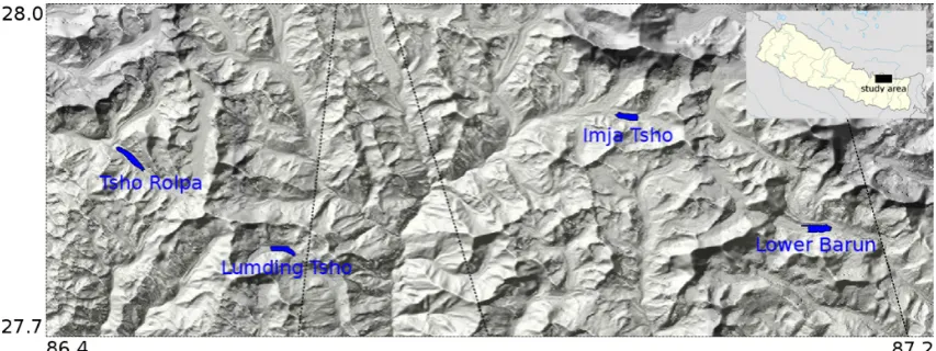
Also, our analysis in Nepal was limited to a narrow section within latitude 27.7◦–28.0◦ and longitude 86.4◦– 87.2◦ in order to cover the area of interest with as many as possible glacial lakes in two TerraSAR-X frames. For
the pre-monsoon (mid April to May) and post-monsoon (October–November) seasons of 2009 and 2010 TerraSAR-X, ENVISAT ASAR, ALOS PALSAR and Radarsat-2 data were selected (see Table 1). In addition, historical ALOS PALSAR and ERS-1/2 SAR images from 1992 to 2008 were considered for a reconstruction of the past evolution of the lakes.
Processing of the satellite radar images can be divided into several logical steps: SAR processing; SAR image registra-tion, if relevant; SAR geocoding; and the generation of lake outlines. For each step quality control tests are introduced. Results of the SAR processing are images at the highest spa-tial resolution (single-look) in the original SAR geometry. Co-registration of SAR images is performed if two or more acquisitions from the same orbit configuration are consid-ered. Co-registration can be achieved automatically with a very high precision on the order of 1/10-th of a pixel (Strozzi et al., 2002). For the terrain-corrected geocoding of satellite SAR data in the range-doppler geometry, a DEM is required. Considering that glacial lakes and their surroundings in high mountainous regions are exposed to large topographic relief and sometimes fast elevation changes (e.g. from ice melt), the quality, resolution and release date of the DEM nomi-nally affects the final accuracy of the geocoding. Globally available digital elevation models include the SRTM DEM and the ASTER GDEM.
Table 1. Satellite SAR data considered in Switzerland, Tajikistan and Nepal.
Site Sensor Mode Date
Switzerland TerraSAR-X ENVISAT ALOS PALSAR
Descending Descending Ascending
29 Jul 2009 22 Jul 2009 21 Jul 2009
Tajikistan TerraSAR-X
TerraSAR-X
ENVISAT
ENVISAT
ALOS PALSAR
Radarsat-2
Radarsat-2
Descending
Ascending
Descending
Ascending
Ascending
Descending
Ascending
24 Aug 2009 26 May 2010 31 Aug 2009 22 May 2010 18 Aug 2010 19 Aug 2009 26 May 2010 08 Sep 2010 8 Aug 2009 15 May 2010 28 Aug 2010 27 Jul 2009 14 Sep 2010 30 May 2010 3 Sep 2010 25 May 2010 29 Aug 2010
Nepal TerraSAR-X
TerraSAR-X
ENVISAT
ENVISAT
ERS-1/2
ALOS PALSAR
Radarsat-2 Radarsat-2
Descending
Ascending
Descending
Ascending
Descending
Ascending
Descending Ascending
Fig. 3. Location map of the glacial lakes of interest in Nepal with footprints of the TerraSAR-X acquisitions (black frames). Image
back-ground is a shaded relief of the SRTM DEM. The inset shows the location of the lakes in Nepal.
The quality of the SRTM4 DEM for terrain-corrected geocoding was further assessed in Switzerland in com-parison to the national-scale DEM derived from aero-photogrammetry with a spatial resolution of 25 m and an es-timated vertical accuracy of 3 m. With both DEMs terrain corrected geocoding was accomplished at 10 m pixel spac-ing. We found that the horizontal geometric accuracy of the terrain-corrected geocoding of all satellite SAR images with SRTM4 is on the order of 30 m. Using the national-scale DEM, on the other hand, the horizontal geometric accuracy of geocoding very-high resolution TerraSAR-X data is on the order of 10 m, whereas the the accuracy of geocoding high resolution ERS-2 SAR, ENVISAT ASAR and ALOS PAL-SAR data is on the order of 20 m.
Lake outlines are produced in the requested projection as shape files from the SAR imagery at 10 m spatial resolution. Water surfaces are very well visible in SAR images because of the generally low backscattering intensity at all microwave wavelengths (Strozzi et al., 2000). We preferred to map the outlines manually because of the challenges and uncertain-ties using automatic methods as a consequence of the speckle of the radar images and of the wind and waves conditions of the lakes, which can increase locally the roughness of the wa-ter surface and thus the backscatwa-tering intensity. Supplemen-tary geotiff’s of the geocoded SAR images with a layover and shadow mask are also produced. The resulting informa-tion is thus in a form that can easily be integrated in the end-users’ geographic information system (GIS) and used within the available infrastructure. Consistency tests based, e.g. on multiple independent results from different time periods or sensors, or validation with reference information of indepen-dent origin, are essential to better characterize the error and to estimate the reliability of the product.
4 Results in Switzerland
Figure 1 shows the Weingarten glacier lake. It represents a suitable test target as it is small (difficult to map), and has potentially confusing land classes such as wet snow and wet sand at the partially very shallow lake shore. Dur-ing a field visit on 29 June 2009, in coincidence with a TerraSAR-X image acquisition, an in-situ lake map was ob-tained by a portable code-based GPS device with EGNOS mode enabled. The indicated horizontal positional accuracy of the GPS was on the order of ±5 m. The TerraSAR-X image of 29 July 2009 around the Weingarten glacier lake terrain-corrected geocoded at 2 m posting based on the Swiss national-scale DEM is presented in Fig. 4. The GPS path to and around the Weingarten lake acquired during the field visit is overlaid in red. The outline of the lake, determined in the SAR intensity image, is shown in blue. In the western part of the lake, the map derived from the TerraSAR-X image matches well with the GPS contour. Potential confusion was observed with the wet snow on the southern side of the lake and the wet sand areas to the north-east. Wet snow cover and sand have indeed a very low SAR backscattering intensity similar to that of water, introducing errors in the classifica-tion of glacier lakes.
Fig. 4. Terrain-corrected geocoded TerraSAR-X image of
29 July 2009 around the Weingarten Lake in Switzerland. The GPS path to and around the Weingarten Lake acquired during the field visit is overlaid in red. The outline of the lake, determined in the SAR intensity image, is shown in blue.
5 Results in Tajikistan
The area of interest in Tajikistan (Fig. 2) includes one large lake (Rivakkul landslide-dammed lake with a maximum length is about 2.5 km) and many smaller, for the most part pro-glacial moraine-dammed, lakes with an extension of a few hectares. For all the satellite SAR data listed in Table 1, we produced geocoded SAR intensity images at 10 m pixel spacing as Geotiff’s and lake outlines as shape files. In the interpretation of the results, it is important to note the differ-ent spatial resolutions of the considered satellite radar data. ENVISAT ASAR and ALOS PALSAR data have a ground resolution of about 25 m and for geocoding the images were oversampled to 10 m. TerraSAR-X and Radarsat-2 data have a ground resolution of about 3 m, and for geocoding the im-ages were undersampled to 10 m.
Figure 5 shows the results over Rivakkul Lake from a TerraSAR-X, an ENVISAT ASAR and an ALOS PALSAR acquisition of almost the same period in the summer of 2009. The identification of the glacial lake and its mapping from the SAR backscattering intensity images was found to be quite straightforward and the results of ENVISAT ASAR and ALOS PALSAR data are not too different from that of TerraSAR-X, although with the latter the border of the lake is sharper due to the higher spatial resolution. A Landsat 5 TM scene of 25 August 2009, received in GeoTIFF format and converted to a RGB color composite of channels 5, 4 and 3, is used for validation. The glacier lake outline derived from the TerraSAR-X satellite image is overlaid to the Land-sat 5 TM image. There is anagreement within±30 m of the lake outlines derived from TerraSAR-X data with the Land-sat 5 TM scene taking the lower resolution of 30 m of the Landsat data and the expected geocoding inaccuracies into
account. In particular, the slight shift between the TerraSAR-X derived lake outlines and the Landsat 5 TM data is well expected from both the geolocation accuracy of Landsat or-thoproducts, which is in the order of several tens to hundred meters, and use of the SRTM4 for the SAR data geocoding.
Also shown in Fig. 5 are a TerraSAR-X and RADARSAT-2 images acquired in the spring of RADARSAT-2010, which were analysed in order to survey the situation before the summer melt. With both sensors the glacier lake in spring cannot be completely identified because it is still frozen on the surface. Smaller lakes in spring images are even more difficult to identify than larger ones. In Fig. 5 we can furthermore see that im-ages from the TerraSAR-X and RADARSAT-2 sensors are comparable despite the different frequencies because of the similar ground-resolution on the order of 3 m.
For the smaller lakes with an extension of a few hundreds of meters located in the upper Shadzuddara area, the identi-fication and mapping of the outlines was more challenging. The higher spatial resolution of TerraSAR-X (Fig. 6a) and Radarsat-2 data make it easier to identify lakes as regions of low backscattering intensity than with ENVISAT ASAR (Fig. 6b) or ALOS PALSAR (Fig. 6c) data. In the interpre-tation of Fig. 6, layover and shadow masks, shown in black, should not be confused with low backscattering intensity. Be-tween August 2009 and August 2010, the area of the poten-tially hazardous glacier lakes did not change significantly, as visible by the lake outlines determined in the summer of 2009. As shown in the Landsat scene of Fig. 6d, most of the lakes were correctly identified within±30 m and the higher spatial resolution of TerraSAR-X is a great advantage for the precise delimitation of the lake shorelines. However, there is an outline derived from low TerraSAR-X backscattering in-tensity which does not correspond to a lake according to the Landsat image. As described in Sect. 4, possible reasons for this misclassification are wet snow cover and wet sand. How-ever, as there is no ground information available, this cannot be verified.
With all SAR sensors, including TerraSAR-X, accurate and complete mapping of ice (i.e. glacier outlines) from the backscattering intensity is very hard. Best results are ex-pected in mid summer, when ice and snow on the glacier sur-face are wet and thus characterized by a low backscattering intensity (Strozzi et al., 1997).
6 Results in Nepal
Fig. 5. Terrain-corrected geocoded TerraSAR-X, ENVISAT ASAR, ALOS PALSAR and Radarsat-2 images for summer 2009 and the early
spring 2010 for Rivakkul Lake in the test-area in Tajikistan. The outline of the lake, determined in the summer TerraSAR-X intensity image, is shown in red. Layover and shadow are masked in black. A coincident Landsat 5 TM image is presented for validation.
periods. Geocoded SAR intensity images in Geotiff format were also computed to support the interpretation of the lake outlines at 10 m pixel spacing. Here, we concentrate on the results for Imja Tsho using ascending orbit SAR data. The length of the pro-glacial, moraine dammed Imja Tsho is ac-cording to the field base map of May 2009 2.03 km.
In general, the identification of the glacial lake and its mapping based on low backscattering intensity is straight-forward for the TerraSAR-X data (Fig. 7a). With ENVISAT (Fig. 7b), the distinction of the shore line and of the glacier tongue is more difficult; also, depending on the presence of wind or ice, the precise delineation of the lake outline is more challenging. The performance of ERS-1/2 SAR data is similar to that of ENVISAT ASAR because these two sen-sors have similar ground resolution and operate at the same
frequency. With ALOS PALSAR data (Fig. 7c), the distinc-tion of the glacier lakes is less problematic than with EN-VISAT ASAR data.
Historical ERS-1/2 SAR data of 1992, 1996 and 2001 and ALOS PALSAR acquisitions of 2007 and 2008 were em-ployed, together with the TerraSAR-X scenes of 2009, to fol-low the temporal changes of the lake area. In Fig. 8 we ob-serve for Imja Tsho between 1992 and 2009 a calving front retreat of more than 500 m and an increase in area from about 0.77 km2to about 1.07 km2, similar to that reported by Ba-jracharya (2009) and Fujita et al. (2009).
Fig. 6. Terrain-corrected geocoded TerraSAR-X, ENVISAT ASAR and ALOS PALSAR images for the summer of 2010 for glacial lakes
with an extension of a few hundred of meters located in the upper Shadzuddara area in Tajikistan. The outlines of the lakes, determined in the TerraSAR-X intensity image of the summer of 2009, are shown in red. Layover and shadow are masked in black. A Landsat 5 TM image of the summer of 2009 is presented for validation.
Fig. 9, highlights in detail this modest change. Considering that the precision of repeat-pass SAR image co-registration is on the order of a 1/10-th of a pixel (Strozzi et al., 2002) and that the ground-range resolution of TerraSAR-X data is on the order of 2 m, we can observe very small lake variations of less than 40 m.
Field observations of three lakes, including Imja Tsho, were provided by ICIMOD for validation. The detailed field investigations of Imja Tsho were performed in May 2009. For the topographic mapping, Sokkia and Pentax total sta-tions were used with the additional support of benchmark networking and Leica SR20 GPS. In order to take the shore line of the lakes, a rubber boat was used and two persons with prisms were sent wherever possible to measure the shore-line at given distance intervals. In some cases near landslides, where it was too dangerous to get ashore, measurements were taken at about 5 to 10 m from the shoreline. The lake outlines delineated based on the survey data in the Modified Universal
Transverse Mercator (MUTM) projection system with 3 de-gree zoning used in Nepal were converted to WGS84 coordi-nates. For integration into Google Earth, offsets varying from about 15 to 85 m, and different in each lake, were manually corrected.
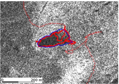
Fig. 7. TerraSAR-X and ENVISAT ASAR images of October 2009
and ALOS PALSAR acquisition of November 2009 of Imja Tsho. Lake outline is derived from the TerraSAR-X data. Areas affected by layover and shadow are masked in black.
towards the glacial terminus while the lateral moraines are almost fixed, except for the changes in water level, which re-sult in corresponding minor changes in the surface area of the lake. The fluctuation of the water level in winter and summer is around 1 to 2 m so that the shoreline of the lakes may vary up to 20 m (1–2 pixels) for shallow water depths. Thus, for monitoring changes in shoreline positions, pixel sizes of less than 10 m will be required.
Fig. 8. Outlines of Imja Tsho derived from ERS-1/2 SAR data of
May 1992 (light green), April 1996 (green), July 2001 (brown), ALOS PALSAR data of November 2007 (violet), May 2008 (pink), and TerraSAR-X data of April 2009 (blue) and October 2009 (red). Background image is the TerraSAR-X data of October 2009.
Fig. 9. Colour composite of the TerraSAR-X acquisitions of
17 Oct 2009 (red and green=yellow) and 14 May 2010 (blue) of Imja Tsho in the original SAR geometry. Ground-resolution (i.e. pixel spacing) is on the order of 2 m.
7 Discussion and conclusions
Fig. 10. Lakes outlines derived from TerraSAR-X data of
April 2009 (blue) and October 2009 (red) and from field surveys (green) in May 2009 for Imja Tsho superimposed to the backscat-tering of the Radarsat-2 acquisition of May 2010.
We reported on the use of very high resolution satellite SAR data for reliable and robust glacial lake mapping. Dur-ing the data interpretation, confusion with wet snow and wet sand areas has to be taken into account because of the very low backscattering intensity similar to that of water. Zones of icebergs and ice debris floating on the lakes, in particular at calving fronts, are confused with land if the interpretation is based on backscatter intensity only. In many cases, though not necessarily in all, multi-temporal analyses might hint to this type of misclassification. In addition, it is important to notice that ascending and descending orbits have different viewing geometries, especially into steep valleys, leading to different hidden areas. DEM quality and availability is cru-cial. We found that for the general use, SRTM4 proved to be the best large scale DEM available, but did not yet incorpo-rate the ASTER GDEM version 2 in our tests. Visualisation of the data in Google Earth showed localisation errors be-tween our SRTM4-based orthorectification with the Google Earth Landsat images of about 10 to 50 m. A drawback in the visual interpretation of satellite images applied in this study, compared to automated methods, is that the area of the lake may vary according to personal subjective interpretations. Another aspect which should be considered in the shoreline mapping with SAR data is shadow or layover of the lake’s shorelines. But up to a 1:10 000 scale the produced outlines fit well with the in-situ validation data. Costs and processing effort of satellite SAR data are similar to that of satellite op-tical data, although interpretation, as explained before, might need more training. Thus, we envisage that the provided ser-vice is mature and complements well the more established optical remote sensing technology (Schneider, 2004; K¨a¨ab et al., 2005a; Quincey et al., 2005; Ukita et al., 2011; Mergili et al., 2012). The users involved in our study are developing more capacity in radar remote sensing analysis as part of on-going and future risk management interventions in Tajikistan and the Himalayas. The huge archive of satellite SAR data
dating back to the nineties allows for reconstruction of large lake historical data over the last 20 yr, and the high observa-tion frequency with several commercial very high resoluobserva-tion sensors (TerraSAR-X, Radarsat-2, Cosmo-SkyMed) permits short reaction time to monitor rapid changes in all affected areas on the globe. With the upcoming Sentinel-1 satellites (Snoeij et al., 2011), additional SAR sensors will become available for monitoring the earth at very high temporal fre-quency.
Acknowledgements. This work was supported by the European Space Agency (ESA) INNOVATOR2-GLOF project. We thank Bojan Bojkov (ESA), Suhaily Mamadraimov (FOCUS) and Malik Ajani (FOCUS) for fruitful discussions. ERS-1/2 SAR, ENVISAT ASAR and ALOS PALSAR courtesy C1F.6504, © ESA respectively JAXA. TerraSAR-X data courtesy HYD0562, © DLR. Radarsat-2 data courtesy SOAR-EU-6634, © CSA. SRTM4 © NASA. ASTER GDEM is a product of METI and NASA. DHM25 Weingarten Lake © 2009 swisstopo.
Edited by: N. Kerle
Reviewed by: M. Mergili and one anonymous referee
References
Ageta, Y., Iwata, S., Yabuki, H., Naito, N., Sakai, A., Narama, C., and Karma: Expansion of glacier lakes in recent decades in the Bhutan Himalayas, in: Debris-Covered Glaciers, edited by: Nakawo, M., Raymond, C., and Fountain, A., IAHS Publication, 165–175, 2000.
ASTER GDEM: ASTER Global Digital Elevation Map Announce-ment, available at: http://asterweb.jpl.nasa.gov/gdem.asp (last access: 9 March 2012), 2012.
Bajracharja, S. R.: Glacial lake outburst floods risk reduction activ-ities in Nepal, Asia-Pacific Symposium on new technologies for prediction and mitigation of sediment disasters, Japan Society of Erosion Control Engineering (JSECE), Tokyo, Japan, 18–19 November 2009.
Bolch, T., Buchroithner, M. F., Peters, J., Baessler, M., and Ba-jracharya, S.: Identification of glacier motion and potentially dangerous glacial lakes in the Mt. Everest region/Nepal using spaceborne imagery, Nat. Hazards Earth Syst. Sci., 8, 1329– 1340, doi:10.5194/nhess-8-1329-2008, 2008.
Bolch, T., Peters, J., Pradhan, B., Yegorov, A. B., Buchroithner, M. F., and Blagoveshchenskiy V. P.: Identification of potentially dan-gerous glacial lakes in the northern Tien Shan, Nat. Hazards, 59, 1691–1714, 2011.
FOCUS: Focus Humanitarian Assistance, available at: http://www. akdn.org/focus (last access: 9 March 2012), 2007.
Frey, H., Paul, F., and Strozzi, T.: Compilation of a glacier inven-tory for the western Himalayas from satellite data: Methods, challenges and results, Remote Sens. Environ., 124, 832–843, doi:10.1016/j.rse.2012.06.020, 2012.
Fujita, K., Sakai, A., Nuimura, T., Yamaguchi, S., and Sharma R.: Recent changes in Imja Glacial Lake and its damming moraine in the Nepal Himalaya revealed by in situ surveys and multi-temporal ASTER imagery, Environ. Res. Lett., 4, 045205, doi:10.1088/1748-9326/4/4/045205, 2009.
GAPHAZ: Glacier and Permafrost Hazards in Mountains, available at: http://www.mn.uio.no/geo/english/research/ groups/remotesensing/projects/gaphaz/index.html (last access: 9 March 2012), 2011.
Haeberli, W., K¨a¨ab, A., Vonder M¨uhll, D., and Teysseire, P.: Preven-tion of debris flows from outbursts of periglacial lakes at Gruben, Valais, Swiss Alps, J. Glaciol., 47, 111–122, 2001.
Huggel, C., K¨a¨ab, A., Haeberli, W., Teysseire, P., and Paul, F.: Re-mote sensing based assessment of hazards from glacier lake out-bursts: a case study in the Swiss Alps, Can. Geotechn. J., 39, 316–330, 2002.
Huggel, C., K¨a¨ab, A., Haeberli, W., and Krummenacher, B.: Regional-scale GIS-models for assessment of hazards from glacier lake outbursts: evaluation and application in the Swiss Alps, Nat. Hazards Earth Syst. Sci., 3, 647–662, doi:10.5194/nhess-3-647-2003, 2003.
ICIMOD: International Centre for Integrated Mountain Devel-opment, available at: http://www.icimod.org (last access: 9 March 2012), 2012.
K¨a¨ab, A.: Remote sensing of permafrost-related problems and haz-ards, Permafrost Periglac., 19, 107–136, 2008.
K¨a¨ab, A., Wessels, R., Haeberli, W., Huggel, C., Kargel, J., and Khalsa, S.: Rapid ASTER imaging facilitates timely assessment of glacier hazards and disasters, EOS T. Am. Geophys. Un., 84, 117–121, 2003.
K¨a¨ab, A., Reynolds, J. M., and Haeberli, W.: Glacier and permafrost hazards in high mountains, in: Global Change and Mountain Re-gions (A State of Knowledge Overview), edited by: Huber, U., Bugmann, H., and Reasoner, M., Springer, Dordrecht, 225–234, 2005a.
K¨a¨ab, A., Huggel, C., Fischer, L., Guex, S., Paul, F., Roer, I., Salz-mann, N., Schlaefli, S., Schmutz, K., Schneider, D., Strozzi, T., and Weidmann, Y.: Remote sensing of glacier- and permafrost-related hazards in high mountains: an overview, Nat. Hazards Earth Syst. Sci., 5, 527–554, doi:10.5194/nhess-5-527-2005, 2005b.
Live images from Swiss Glaciers: available at: http://people.ee.ethz. ch/∼glacier/acam.html (last access: 9 March 2012), 2012. Mergili, M. and Schneider, J. F.: Regional-scale analysis of lake
outburst hazards in the southwestern Pamir, Tajikistan, based on remote sensing and GIS, Nat. Hazards Earth Syst. Sci., 11, 1447– 1462, doi:10.5194/nhess-11-1447-2011, 2011.
Mergili, M., Schneider, D., Worni, R., and Schneider, J. F.: Glacial Lake Outburst Floods (GLOFs): challenges in prediction and modeling, in: Proceedings of the 5th International Conference on Debris-Flow Hazards Mitigation: Mechanics, Prediction and As-sessment, edited by: Genevois, R., Hamilton, D. L., and Prestin-inzi, A., Padua, Italy, 14–17 June, 2011, Italian J. Eng. Geology and Environ., 973–982, 2011.
Mergili, M., Kopf, C., M¨ullebner, B., and Schneider, J. F.: Changes of the cryosphere in the high-mountain areas of Tajik-istan and Austria: a comparison, Geogr. Ann. A, 94, 79–96, doi:10.1111/j.1468-0459.2011.00450.x, 2012.
Mool, P. K., Bajracharya, S. R., and Joshi, S. P.: Inventory of glaciers, glacial lakes and glacial lake outburst floods: monitor-ing and early warnmonitor-ing systems in the Hindu Kush-Himalayan re-gion – Nepal, Kathmandu, ICIMOD, 2001a.
Mool, P. K., Wangda, K. D., and Bajracharya, S. R: Inventory of glaciers, glacial lakes and glacial lake outburst floods: monitor-ing and early warnmonitor-ing systems in the Hindu Kush-Himalayan re-gion – Bhutan, Kathmandu, ICIMOD, 2001b.
Narama, C., Duishonakunov, M., K¨a¨ab, A., Daiyrov, M., and Ab-drakhmatov, K.: The 24 July 2008 outburst flood at the western Zyndan glacier lake and recent regional changes in glacier lakes of the Teskey Ala-Too range, Tien Shan, Kyrgyzstan, Nat. Haz-ards Earth Syst. Sci., 10, 647–659, doi:10.5194/nhess-10-647-2010, 2010.
Nuth, C. and K¨a¨ab, A.: Co-registration and bias corrections of satel-lite elevation data sets for quantifying glacier thickness change, The Cryosphere, 5, 271–290, doi:10.5194/tc-5-271-2011, 2011. Quincey, D., Lucas, R., Richardson, S., Glasser, N., Hambrey,, M.,
and Reynolds, J.: Optical remote sensing techniques in high-mountain environments: application to glacial hazards, Progr. Phys. Geogr., 29, 475–505, 2005.
Raymond, M., Wegmann, M., and Funk, M.: Inventar gef¨ahrlicher Gletscher in der Schweiz, Mitteilung VAW 182, 2003.
Rodriguez, E., Morris, C., Belz, J., Chapin, E., Martin, J., Daffer, W., and Hensley, S.: An assessment of the SRTM topographic products, Technical Report JPL D-31639, Jet Propulsion Labo-ratory, Pasadena, California, 143 pp., 2005.
Schneider, J. F.: Risk assessment of remote geohazards in Western Pamir, GBAO, Tajikistan, Proc. Int. Conference on High Moun-tain Hazard Prevention, Vladikavkaz, 252–255, 23–26 June, 2004.
Schneider, J. F., Gmeindl, M., Traxler, K., et al.: Risk Assessment of Remote Geohazards in Central and Southern Pamir/GBAO, Tajikistan, follow up of the report from October 2002 Assess-ment of Natural Hazards in Shahdara, GBAO, Tajikistan, Report to the Ministry of Emergency, Tajikistan and the Swiss Agency for Development and Cooperation (SDC), 2004.
Snoeij, P., Torres, R., Brown, M., Geudtner, D., and Davidson, M.: Sentinel-1 Mission Implementation, Proc. FRINGE 2011, ESA-ESRIN, Frascati (Rome), Italy, 19–23 September 2011. Strozzi, T., Wiesmann, A., and M¨atzler, C.: Active microwave
sig-natures of snow covers at 5.3 and 35 GHz, Radio Sci., 32, 479– 495, doi:10.1029/96RS03777, 1997.
Strozzi T., Dammert, P., Wegm¨uller, U., Martinez, J. M., Askne, J., Beaudoin, A., and Hallikainen, M.: Landuse Mapping with ERS SAR Interferometry, T. Geosci. Remote, 38, 766–775, doi:10.1109/36.842005, 2000.
Strozzi, T., Luckman, A., Murray, T., Wegm¨uller, U., and Werner, C.: Glacier motion estimation using SAR offset-tracking procedures, IEEE T. Geosci. Remote, 40, 2384–2391, doi:10.1109/TGRS.2002.805079, 2002.
Strozzi, T., Farina, P., Corsini, A., Ambrosi, C., Th¨uring, M., Zil-ger, J., Wiesmann, A., Wegm¨uller, U., and Werner, C.: Sur-vey and monitoring of landslide displacements by means of L-band satellite SAR interferometry, Landslides, 2, 193–201, doi:10.1007/s10346-005-0003-2, 2004.
Strozzi, T., Paul, F., and K¨a¨ab, A.: Glacier mapping with ALOS PALSAR Data within the ESA GlobGlacier Project, Proc. ESA Living Planet Symposium, Bergen, Norway, 28 June to 2 July 2010a.
Strozzi, T., Delaloye, R., K¨a¨ab, A., Ambrosi, C., Perruchoud, E., and Wegm¨uller, U.: Combined observations of rock mass movements using satellite SAR interferometry, differ-ential GPS, airborne digital photogrammetry, and airborne photography interpretation, J. Geophys. Res., 115, F01014, doi:10.1029/2009JF001311, 2010b.
Swiss Glacier Monitoring Network: available at: http://glaciology. ethz.ch/swiss-glaciers (last access: 9 March 2012), 2010. Tadono, T., Shimada, M., Yamanokuchi, T., Ukita, J., Narama, C.,
Tomiyama, N., Kawamoto, S., Fujita K., and Nishimura, K.: Development of glacial lake inventory in Bhutan using “Daichi” (ALOS), Proc. IGARSS, 3202–3205, doi:10.1109/IGARSS.2011.6049900, 2011.
Ukita, J., Narama, C., Tadono, T., Yamanokuchi, T., Tomiyama, N., Kawamoto, S., Abe, C., Uda, T., Yabuki, H., Fujita, K., and Nishimura, K.: Glacial lake inventory of Bhutan using ALOS data: methods and preliminary results, Ann. Glaciol., 52, 65–71, doi:10.3189/172756411797252293, 2011.