Abstract - In wireless sensor networks (WSNs), energy efficiency is considered to be a crucial issue due to the limited battery capacity of the sensor nodes. Due to the converge cast nature of traditional WSNpacket forwarding approaches resulting in the concentration of data traffic towards the sinks, the nodes in the vicinity of the static (immobile) sinks are more likely to deplete their batteries before other nodes, leading to the energy hole problem disruptions in the topologyand reduction in the sensing coverage. Load-balancing is implicitly provided by the sink mobility, shifting the hotspots around the sinks and spreading the increased energy drainage around the sink, which helps achieving uniform energy consumption that extends the network lifetime. Sink mobility also has security benefits where the mobility makes the sinks more difficult to compromise than static sinks. To ease the data collection efforts in such scenarios, thus making mobile sinks more applicable, heterogeneous architectures stemming from the marriage of WSNs with other types of networks are also possible.
Index Term– Virtual Co-ordinate mapping Algorithm, WSN Topology.
I. INTRODUCTION
A. SENSOR NETWORKS
Sensor networks are deployed to sense, monitor, and report events of interest in a wide range of applications including, but are not limited to, military, health care, and animal tracking. In many applications, such monitoring networks consist of energy constrained nodes that are expected to operate over an extended period of time, making energy efficient monitoring an important feature for unattended networks. In such scenarios, nodes are designed to
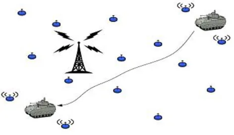
transmit information only when a relevant event is detected (i.e., event-triggered transmission). Consequently, given the location of an event-triggered node, the location of a real event reported by the node can be approximated within the nodes sensing range. The locations of the combat vehicle at different
time intervals can be revealed to an adversary observing nodes transmissions. There are three parameters that can be associated with an event detected and reported by a sensor node: the description of the event, the time of the event, and the location of the event.
Fig 1. Sensor network deployed in a battlefield
B. B.WIRELESS AD HOC SENSOR NETWORK: APPLICATION
Awireless ad hoc sensor network consists of a number of sensors spread across a geographical area. Each sensor has wireless communication capability and some level
Volume-6 Issue-2
International Journal of Intellectual Advancements
and Research in Engineering Computations
Enhanced Ring Routing Protocol Model for
Energy-Efficient Routing Protocol for WSN
with Cluster Head and Mobile Sink Node
1
Mr. R. NavinKumar, M.C.A.,M.Phil Assistant Professor/MCA
2
Mr. S. Sasidharan, III MCA
Department of MCA, Nandha Engineering College, Erode-52
E-Mail Id: [email protected], [email protected]
of intelligence for signal processing and networking of the data. Military sensor networks to detect and gain as much information as possible about enemy movements, explosions, and other phenomena of interest. Sensor networks to detect and characterize Chemical, Biological, Radiological, Nuclear, and Explosive (CBRNE) attacks and material. Sensor networks to detect and monitor environmental changes in plains, forests, oceans, etc. Wireless traffic sensor networks to monitor vehicle traffic on highways or in congested parts of a city.Wireless surveillance sensor networks for providing security in shopping malls, parking garages, and other facilities. Wireless parking lot sensor networks to determine which spots are occupied and which are free.The above list suggests that wireless ad hoc sensor networks offer certain capabilities and enhancements in operational efficiency in civilian applications as well as assist in the national effort to increase alertness to potential terrorist threats. Two ways to classify wireless ad hoc sensor networks are whether or not the nodes are individually addressable, and whether the data in the network is aggregated. The sensor nodes in a parking lot network should be individually addressable, so that one can determine the locations of all the free spaces.
C. WIRELESS AD HOC SENSOR NETWORK: GOAL
The ability of the sensor network to aggregate the data collected can greatly reduce the number of messages that need to be transmitted across the network. This function of data fusion is discussed more below. The basic goals of a wireless ad hoc sensor network generally depend upon the application, but the following tasks are common to many networks. Determine the value of some parameter at a given location: In an environmental network, one might one to know the temperature, atmospheric pressure, amount of sunlight, and the relative humidity at a number of locations. This example shows that a given sensor node may be connected to different types of sensors, each with a different sampling rate and range of allowed values. Detect the occurrence of events of interest and estimate parameters of the detected event or events: In the traffic sensor network, one would like to detect a vehicle moving through an intersection and estimate the speed and direction of the vehicle. Classify a detected object vehicle in a traffic sensor networks a car, a mini-van, a light truck, a bus, etc. Track an object: In a military sensor network, track an enemy tank as it moves through the geographic area covered by the network.
D. ISSUES
Wireless ad hoc sensor network requirements Large number of (mostly stationary) sensors aside from the deployment of sensors on the ocean surface or the use of mobile, unmanned, robotic sensors in military operations, most nodes in a smart sensor network are stationary. Networks of 10,000 or even 100,000 nodes are envisioned, so scalability is a major issue. Low energy use: Since in many applications the sensor nodes will be placed in a remote area,
service of a node may not be possible. In this case, the lifetime of a node may be determined by the battery life, thereby requiring the minimization of energy expenditure.
II. LITERATURE SURVEY
A. DATA COLLECTION IN WIRELESS SENSOR NETWORKS WITH MOBILE ELEMENTS SURVEY
Authors:
Mario di francesco Sajal k. Das crewman
Wireless sensor networks (WSNs) have emerged as an effective solution for a wide range of applications. Most of the traditional WSN architectures consist of static no des which are densely deployed over a sensing area. Recently, several WSN architectures based on mobile elements (MEs) have been proposed. Most of them exploit mobility to address the problem of data collection in WSNs. In this paper we first define WSNs with MEs and provide a comprehensive taxonomy of their architectures, based on the role of the MEs. we present an overview of the data collection process in such scenario and identify the corresponding issues and challenges. On the basis of these issues, we provide an extensive survey of the related literature. Finally, we compare the underlying approaches and future research directions. In recent years Wireless Sensor Networks (WSNs) have become an established technology for a large number of applications, ranging from monitoring (e.g., pollution prevention, precision agriculture, structures and buildings health), to event detection (e.g., intrusions, fire/flood emergencies) and target tracking. WSNs usually consist of a large number of sensor no des, which are battery-powered tiny devices.
B. STRATEGIES FOR DATA DISSEMINATION TO MOBILE SINKS INWIRELESS SENSOR NETWORKS
Authors:
Elyes ben hamida, Guillaume chelius
communication paradigm, where sensors collect environmental data and forward them towards a static base station or sink.
GHT (Geographic Hash Table) has introduced the concept of data-centric storage (DCS). GHT hashes data-type into geographic coordinates and stores the corresponding data at the sensor node (a.k.a. home-node) the closest to these coordinates. Two-Tier Data Dissemination (TTDD) provides a scalable and efficient data delivery to multiple mobile sinks. Each source pro-actively builds a grid structure by dividing the sensor field into cells with dissemination nodes located at the crossing points of the grid. Queries and data are then transmitted along the grid. Railroad [4] builds and exploits a virtual infrastructure, called a rail. This rail is placed in the middle area of the sensor field so that each node can easily access it. When a source detects a new event, the data remains locally stored and the corresponding meta-data is sent to the rail. This infrastructure is then used by the mobile sink to retrieve meta-data, with the queries traveling around the rail. The Column-Row Location Service (XYLS) is a proactive location service which can be used to disseminate data reports. In XYLS, source nodes disseminate and replicate the data reports in the north and south directions from their current location, such that sink queries can intersect it subsequently.
C. MAXIMIZING THE LIFETIME OF WIRELESS SENSOR
NETWORKS WITH MOBILE SINK IN
DELAY-TOLERANT APPLICATIONS
Authors:
Youngsangyun , Ye xia
This paper proposes a framework to maximize the lifetime of the wireless sensor networks (WSN) by using a mobile sink when the underlying applications tolerate delayed information delivery to the sink. Within a prescribed delay tolerance level, each node does not need to send the data immediately as it becomes available. Instead, the node can store the data temporarily and transmit it when the mobile sink is at the most favorable location for achieving the longest WSN lifetime. To find the best solution within the proposed framework, we formulate optimization problems that maximize the lifetime of the WSN subject to the delay bound constraints, node energy constraints, and flow conservation constraints.
D. SENSOR INFORMATION NETWORKING ARCHITECTURE AND APPLICATIONS
Authors:
Chavalit srisathapornphat Chaiporn jaikaeo
Chien-chung shen
This article introduces a sensor information networking architecture, called SINA, that facilitates querying, monitoring, and tasking of sensor networks. SINA plays the role of a middleware that abstracts a network of sensor nodes as a collection of massively distributed objects. The SINA’s execution environment provides a set of configuration and communication primitives that enable scalable and energy-efficient organization of and interactions among sensor objects. On top the execution environment is a programmable substrate that provides mechanisms to create associations and coordinate activities among sensor nodes.Users then access information within a sensor network using declarative queries, or perform tasks using programming scripts.
The advent of technology has facilitated the development of small, low power devices that combine programmable general-purpose computing with multiple sensing and wireless communication capability. Composing these sensor nodes into sophisticated, ad hoc computational and communication infrastructures to form sensor networks will have significant impact on applications ranging from military situation awareness to factory process control and automation.
E. ANALYZING MAC PROTOCOLS FOR LOW
DATA-RATE APPLICATIONS
Authors:
Andreas meier Koen langendoen
The fundamental WSN requirement to be energy-efficient has produced a whole range of specialized Medium Access Control (MAC) protocols. They differ in how performance latency, throughput) is traded off for a reduction in energy consumption. It depends on specific details of the
application requirements and hardware characteristics
without external control by human operators after initial deployment.
III.SYSTEM METHODOLOGY
A. GENERAL BACKGROUND
The sensor node exploits a path depending only on the location information of neighbor nodes in geographic routing, routing protocol based on geographic information is more efficient. Due to its high expansibility and low influence by network size, geographic routing has wide application prospects in large scale WSNs. Routing protocols based on virtual coordinate have various forms, which make them flexible to implement according to practical network conditions without constraint from the physical locations. Though greedy algorithm is simple in principle and low in complexity, it cannot be applied to all sensor nodes when some routings based on virtual coordinate are adopted in the network.
B. DESCRIPTION
ROUTING VOID IN GEOGRAPHIC ROUTING
In geographic routing, when greedy forwarding is adopted, it can be easily interrupted due to the terrain or radio coverage, for example, pools, hills or buildings which locate in the sensor area. The finite distance of communication range can also cause greedy forwarding failing. When a sensor node tries to forward the packet to one neighbor node that is geographically closer to the destination node than itself, but such node doesn’t exist, then a routing void is encountered. Greedy forwarding fails in this situation.
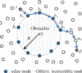
A node n1 tries to forward a packet to the destination node d1 by greedy forwarding in multi hops. First, node n1 sends the packet to n2 by greedy forwarding. Since the neighbor nodes set of n2 is {n1, n3, n4}, none of which is closer to the node destination d1, and then a routing void is encountered and greedy forwarding fails to deliver the packet.
Fig 2.Routing void in greedy forwarding
Similarly, a routing void is encountered at node n5 when it tries to forward a packet to the destination node d2.
Around the obstacle area, greedy forwarding fails at node n5 as described above. But for different destinations, greedy forwarding may not fail at the same node. For example, if n5 tries to forward a packet to the destination node d1, packet can arrive at d1 along with the path n5→n6→n7→d1 without routing problem.
Fig 3. Edge structure without routing void
C. BYPASSING VOID ROUTING PROTOCOL - VIRTUAL COORDINATE MAPPING
Void processing mode is composed of three phases, according to processing in the order, respectively void detecting, virtual coordinate mapping and void region dividing. After the implement of void processing mode, the virtual coordinates of edge nodes are established. Then greedy mode is reactivated, these edge nodes that have the virtual coordinates can be selected as the relay node by greedy algorithm.
Void Detecting Phase
The main function of the void detecting phase is to collect edge node information around the routing void after the void is encountered. When routing void emerges in the transmission process, the node at which the greedy mode fails is defined as the discovery node. After the discovery node discovers a void, it stores data packets temporarily at first, then generates a void detecting packet for starting a void detecting process. During the process, the void detecting packet records the time when the void is encountered, edge node’s label and geographical coordinate.In the process of void detecting, there may be multiple discovery nodes in the same void region, so there may be multiple detecting packets around current void at the same time. In this condition, in order to avoid the repetition that different detecting packets detect and forward around the same void, the edge nodes record the time when void is encountered after receiving a detecting packet.
The virtual coordinate mapping phase is responsible for mapping the edge node coordinates stored in the detecting packed to a virtual circle, i.e., converting a structure composed of edge nodes to the structure without routing void. The detecting packet that returns to the discovery node stores all the information of the current void, including node’s label and geographic coordinates. (x j, y j), (x j+1, y j+1),..(ximax, yimax ) represent the nodes coordinates, thus the center coordinate of the void is
The maximum distance between edge nodes and the void center is
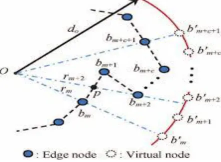
After virtual coordinate mapping, the discovery node generates a distributing packet which contains the virtual coordinates and center of virtual mapping circle. The distributing packet is forwarded along the way (the routing void edge) that the detecting packet establishes. Every edge node broadcasts a message containing both virtual coordinate and center of virtual mapping circle to its neighbor nodes after receiving the distributing packet. In this way, both the edge nodes and the neighbor nodes learn the void information.
Fig 4. Virtual Coordinate Mapping
In the Fig. 4, O is the center of void, and the arc is a part of the virtual mapping circle. The virtual coordinates of edge node b1, b5 are b’1 and b’5 respectively and the virtual coordinates of edge node b2, b3, b4 are b’2, b’3, b’4 respectively, locating between the virtual node b’1 and b’5.
Void Region Dividing Phase
The main function of the void region dividing phase is to divide the surrounding area of the void into three different regions, in which different routing strategies are applied. According to the void position and the location of destination node of the packets, the surrounding area of a void is divided into approaching region, departing region and free region. O is the center of mapping virtual circle, d is the destination node, the circle shown in dotted line is the virtual mapping circle. Two tangents to the mapping virtual circle through the destination node have the intersections at points m and n respectively.
Fig 5.Void Region Dividing
Routing Based on Virtual Coordinate
After implementing the three phases above, the edge nodes of void contain two types of location information which are geographic coordinates and virtual coordinates, and that surrounding area of routing void has been divided into three different regions according to the destination node. Discovery node restarts greedy mode by utilizing the virtual coordinates, the packet stored in the first phase is forwarded to relay nodes. In the greedy mode, the ways to select relay node in three regions are different, but they all use the greedy algorithm.
Virtual Coordinate Mapping Algorithm
Step 1:
Node receives data packet;
Step 2:
Determine if virtual coordinate is used by itself or its neighbors, if any, go to step 3, or go to step 4;
Step 3:
If there is no routing void encountered in greedy algorithm during the process of selecting relay node, go to step 6, or go to step 5;
Step 5:
Void process mode is activated, and virtual coordinates of edge nodes around routing void are established. Then go to step 3;
Step 6:
Node sends packet to the relay node. All the data packets arriving at destination mainly experience three different routing processes in Bypass Void Routing –Virtual Coordinate Mapping.
The first is arriving at destination without void problem:
step 1→step 2→step 4→step 6. In this process, no void is encountered, the selection of relay nodes is depending on greedy forwarding only.If a void is encountered for the first time during the packet delivery, the process in Bypass Void Routing –Virtual Coordinate Mapping is: step 1→step 2→step 4→ step 5→step 3→step 6. In this process, virtual coordinates of edge nodes around current void are established. The third process is: step 1→step 2→step 3→step 6. Pseudo code for Virtual Coordinate Mapping Algorithm
Initialize i=j, m=φ
While i<= imax do
If only one interaction x’, y’ between ri and u then (x’i,y’i) = (x’,y’)
If M=φ then
Xtemp, ytemp = (x’,y’) Else
X’i-c = x’ + xc Y’i-c = y’ +yc
Remove bi-c from M End while
End if Else
Add bi to M End if
i++ End while
IV. CONCLUSION
The project introduces a method to improve routing performance with small routing states. It solves the local minimum problem by embedding a network topology to a low-dimensional Euclidean space where hop distances between pairwise nodes. Based on accurate hop distance comparison between neighboring nodes, the greedy forwarding can find the shortest path between two nodes. The project shows that the routing quality can be improved by embedding a network topology to a Euclidean space. Nearest node location need not be retrieved from base station, since partial path information (achieved through maintaining trusted value of the path) is maintained. Calculation overhead is reduced since it maintains the quality details of previous communications.
REFERENCES
[1] J. Luo and J.-P. Hubaux, “Joint mobility and routing for lifetime elongation in wireless sensor networks,” in Proc. INFOCOM 24thAnnu. Joint Conf. IEEE Comput. Commun. Soc., vol. 3, 2005, pp. 1735–1746.
[2] I. Chatzigiannakis, A. Kinalis, and S. Nikoletseas, “Efficient data propagation strategies in wireless sensor networks using a single mobile sink,” Comput. Commun., vol. 31, no. 5, pp. 896–914, 2008.
[3] M. Di Francesco, S. K. Das, and G. Anastasi, “Data collection in wireless sensor networks with mobile elements: A survey,” ACM Trans. Sens. Netw., vol. 8, no. 1, pp. 1–31, 2011.
[4] Z. Wang, S. Basagni, E. Melachrinoudis, and C. Petrioli, “Exploiting sink mobility for maximizing sensor networks lifetime,” in Proc. 38th Annu. Hawaii Int. Conf. Syst. Sci., 2005, p. 287.
[5] E. Hamida, and G. Chelius, “Strategies for data dissemination to mobile sinks in wireless sensor networks,” IEEE Wireless Commun., vol. 15, no. 6, pp. 31–37, Dec. 2008.