5
X
October 2017
Police Smart Support
Sagar Mali1, Prof. Sujit A. Ahirrao2, Saurabh Kasar3, Prasannakumar Deo4, Jitendra Bachhav5
2
Assistant Professor, Department of Computer Engineering, Sandip Institute of Engineering & Management2 UG Students, Department of Computer Engineering, Sandip Institute of Engineering & Management1,3,4,5
Abstract: Technological advancements in the field of communications and locations have taken a marvellous boost since a decade. But still, we see a lot of police forces use the same age-old Walkie-Talkie systems to communicate very important information. This needs to be replaced with new technologies to improve the overall working and efficiency of all the departments of the forces all-together. This can be done with introducing Location Tracing with the help of A-GPS and Android-Based applications and android devices handed over to each and every personnel of the force. It can also be implemented on every equipment and vehicles that are being used by the Police. This enables a faster communication among the various departments of emergency services and also improves the Response-Time of the forces drastically.
Keywords: Call Log, Message Log, Content of calls and message, browser, log, location (GPS).
I.INTRODUCTION
Android is the most commonly used operating system developed by Google (American Company). It is mostly used in smartphones as well as tablets. There isn’t a time in the day when the newer generation can do a task without the use of a smartphone. Basically, smartphones and android is the most valued need of today’s life. Now, this technology needs to applied in every walk of life. Be it as simple as day-to-day chores, or complex tasks like space monitoring.
As we know Police services are sensitive type of services which help the people to stay safe and protected in their homes and outdoors. It is because of the Police that people can roam around free and safe from the wrong elements of the society. But there have been cases where the police have been ineffective or non-capable of rendering faster implementation of orders due to lack of communication between them. Thus, it is a need to revolutionize the whole of communications system and replace it with the latest technology that is Android.
This system will contain an Android Application and a website. The police officer will sign-in into account and then will click on to the send location button. Mobile will send location and website will show the device location. Police can also send distress calls for backup. Improves working of all the police system.
This system will change the overall working of communications in the police system. The communication will be faster, safe, dependable and very easy to use. The response time to a situation will be very accurate and more effective than the age-old communication systems used by the forces.
II. LITERATURE SURVEY
Hind Abdalsalam, Abdallah Dafallah [1], The paper studies that GPS tracking can be used of many things in today’s world; the system can be used for children, asset, as spy equipment, car and or any equipment tracking. This paper presents an accurate, reliable real-time tracking system using GPS (global positioning system) and GSM (global system for mobile communication) services. The system permits localization of a portable traceable unit and transmits the position to the tracking centre. The GPS tracking system consists of the tracking centre where the portable device’s location should be monitored and portable tracked device attached to a person, vehicle or any asset. The mobile tracked android device receives its coordinates from the GPS and sends these coordinates as SMS via GSM modem to the tracing centre, which is simply a server computer with many interface programs to display the location on Google maps using free versions of Google Maps APIs (application programming interfaces). The testing shows that the system meets its objective of being low-cost, accurate, real time and adaptive for various applications.
efficiently in real-time on a multicore processor. We demonstrate the Speed-O system using the Google Maps API as a very interactive map that refreshes every 60 seconds with the average speed displayed as color-coded road sections.
He Li, Lai Zhijian [3], The study and implementation of mobile GPS navigation system based on Google Map: - The paper explains GPS-enabled mobile devices such as smart phones and tablets are extremely popular today. Billions of such devices are currently in use. The application and research potentials of these devices are limitless, but how accurate are these devices? The research team used Root Mean Square Error (RMSE), Average Euclidean Error (AEE), and Central Error (CE) to specify and calculate the precision and accuracy of six popular GPS-enabled mobile devices running on two different OS (Android and iOS) from the measurements in Clarksville, Tennessee, USA. Spatial data (multiple measurements) consisting of latitude and longitude coordinates of positions reported by the six GPS-enabled mobile devices had been collected at nine different physical locations (control points). The results of the field data were ranked and compared through the use of one scientific and two realistic measuring protocols. This scientific protocol was designed to simulate standard scientific experiments (a controlled experiment). The realistic protocols were designed to recreate daily usage of mobile devices (holding a mobile phone at around waist level).
In this preliminary study, it was discovered that various mobile devices perform variedly in terms of RMSE, AEE, and CE. It also showed that the protocol is not a statistically significant contributing factor to the variation in the measurements in terms of accuracy or precision.
The device and the location are statistically significant contributing factors to the difference in the measurements in terms of accuracy and precision. The interaction between device and protocol is not a statistically significant contributing element. It is also discovered that the devices are statistically lesser accurate than they are precise.
Leong Lee, Matthew Jones, Gregory S. Ridenour, Sam J. Bennett, Arisha C. Majors, Bianca L. Melito, Michael J. Wilson [4], Comparison of Accuracy and Precision of GPS-Enabled Mobile Device: According to the authors, Google Maps API provides a number of utilities for adding individual content to the Google map and various web map applications can be explored based on Google Maps API. Assisted global positioning systems (A-GPS) has been adopted by mobile operation companies as the highest accurate positioning way in mobile location based services. This paper proposes a solution of mobile navigation system that realizes such functions as Google map browse and query, bus lines search, the rapid local positioning on your mobile phone etc. In this paper, we discuss the system technical scheme and the key realization technologies. Finally, the test result is displayed on the device (Nokia N73). The results prove that the solution of mobile navigation system based on Google Maps is very feasible and valid, and it can be installed on PDA’s, mobile phones and other portable devices and or information terminals.
‘Earth NGO’ [5], Police Mitra Maharashtra (Android Application): - Police Mitra is an initiative by the Maharashtra Police to make the police administration friendly and easily-accessible. The police Mitra assists the police in policing duties like crime prevention, crowd management, and traffic management, safety of women, children and senior citizens.
To make the society safer and secure the active individual and assistance of the citizens is very important and this is part of the community policing initiative which is being implemented across the globe. If any person wants to be a Police Mitra and wishes to spare his time to work hand in hand with the Police and in his field of interest is required to register as ‘Police Mitra’ by using this app available on Google Play store.
‘Mother Technologies Project Ventures’ [6], Telangana Traffic Police: - This Hyderabad Traffic Police Application aims at increasing public engagements and providing them with easy access information about all the traffic situations in Hyderabad. This app is constrained to only updates about the traffic and roads related situation prevailing in the city. The Hyderabad police monitors and updates the app with the latest updates of the traffic situations, mishaps and blockages that are present or have occurred in the city. This helps control the over-loaded traffic in specific parts of the city.
III. EXISTING SYSTEM
The existing system mostly includes use of walkie-talkie for communication between the police force personnel. This can be easily tampered with by simply tuning into the same frequency being used. Also, exact and precise location cannot be conveyed with this old system. Lack of fast communication can result into severe consequences.
There is an app to address public grievances by the police system. But there is no form of location-based communication system existing in the police force. It is a community policing initiative designed to provide a platform to the citizens willing to spare time to work with the police force. It provides citizens with updates of the city. There are various applications which provide only information regarding situations in the locality or are a platform for the citizens to post updates or report grievances [5], [6].
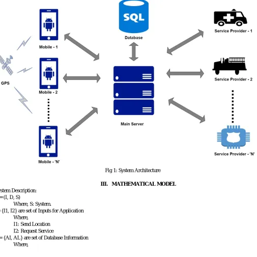
The proposed system will include of an android application which will be installed on an android device which will be carried by the police personnel. With the help of the app, the exact location of the personnel can be tracked on a website on a server/main computer system present at the police headquarters. Different services of different categories can be requested by the personnel with simply a touch on the screen. Sensitive information can be conveyed through the app. And the most important thing is it will all be safe and protected through 128-bit SSL present in Android.
Firstly, the police personnel (user) will have login credentials which will be used to login to the application. Then the web-server will be able to track the exact location of the device and it will be displayed on the web-portal. There will be options on the application which are going to help the user to report situations and also call for backup if need arises. A call for backup can be for a service by a service provider. Service providers can be a variety of services including Fire Brigade, Ambulance, Police Action forcesetc.
[image:4.612.50.555.239.744.2]device will be android with android version 5.0+. The server has to have basic server requirements fulfilled. Application will be non-heavy to the processor as it uses basic android functionalities and resources.
Fig 1: System Architecture
III. MATHEMATICAL MODEL
System Description: S = (I, D, S)
Where, S: System.
I= {I1, I2} are set of Inputs for Application Where,
I1: Send Location I2: Request Service
AI: Agent Information AL: Agent Location Ack: Acknowledgement S = {S1, S2, S3} are set of Services
Where,
S1: Service Provider 1 S2: Service Provider 2 S3: Service Provider 3
Success Condition: To do proper Location Fetching, Request Service, Send Acknowledge, and Provide Service. Failure Condition: No database, internet connection
V. GOALS AND OBJECTIVES
A To get exact location of police officer.
B If any police officer gets into a situation, police headquarter can easily send backup for help by tracing the device location. C Improves crucial response time which is essential in an emergency situation.
D Easy communication among all of police and support staffs can be achieved.
E To replace current walkie-talkie based communication system with the latest technology i.e. Android.
VI. CONCLUSION
Proposed system will change the current scenario of the efficiency of Police communications system. It will improves the response time of Police Forces to a situation drastically. It will also ensure the security of police officials and forces in an event of an emergency. Fast deployment of troops and forces can be achieved through proper location and situation communication. Also, security and safety of sensitive data about police personnel can be taken care of by protecting the application. Secure connection on both the ends can be obtained by communication through the application.
REFERENCES
[1] Hind Abdalsalam, Abdallah Dafallah, “Design and implementation of an accurate real time GPS tracking system”, E-Technologies and Network for Development (ICeND), Conference On 29 April 2014 in Beirut, Lebanon.
[2] Evangelos Denaxas, Savvas Mpollas, Dimitrios Vitsios, Christoforos Zolotas, Dimitris G. Bleris, Georgios M. Spanos, Nikos P. Pitsianis, “Real-time urban traffic information extraction from GPS tracking of a bus fleet”, International Journal of Engineering and Computer Science Computational Intelligence in Vehicles and Transportation system(CIVTS),2013.”
[3] He Li, Lai Zhijian, “The study and implementation of mobile GPS navigation system based on Google Map”, Computer and Information Application (ICCIA), 2010 Inter-national Conference in Tianjin, China
[4] Leong Lee, Matthew Jones, Gregory S. Ridenour, Sam J. Bennett, Arisha C. Majors, Bianca L. Melito, Michael J. Wilson: “Comparison of Accuracy and Precision of GPS-Enabled Mobile Devices, Computer and Information Technology” (CIT), 2016 IEEE International Conference in Nadi, Fiji.
[5] ‘EARTH NGO’, Police Mitra Maharashtra,2017